Articoli simili a Antique Map of Greece and the Cyclades, 1903, with Many Details and Inset Maps


Vuoi altre immagini o video?
Richiedi altre immagini o video al venditore
1 di 10
Antique Map of Greece and the Cyclades, 1903, with Many Details and Inset Maps
Informazioni sull’articolo
Title: Antique Map of Greece and the Cyclades, 1903, with Intricate Detail and Inset Maps
Description: This antique map, titled "Greece with Its Islands, Including the Cyclades," was engraved and published in 1903 by W. & A.K. Johnston in Edinburgh and London. It provides an exquisite depiction of Greece and its surrounding islands, capturing the stunning geography and complex political landscape of this historically rich region at the start of the 20th century.
The map’s delicate pastel coloring in shades of pink, green, and yellow highlights the boundaries of Greek provinces, showing major cities, rivers, and mountain ranges with precision and clarity. Key areas such as the Peloponnese, Thessaly, Epirus, and Central Greece are detailed, offering insight into a landscape shaped by millennia of history and mythology.
Inset maps of Corfu & Paxo and the Cyclades offer additional detail, emphasizing the maritime and cultural importance of these islands in the Aegean and Ionian Seas. The Cyclades inset, in particular, is a visual highlight, capturing the unique charm and interconnectedness of these legendary islands.
For collectors, historians, and lovers of Greek culture, this map is more than a decorative item—it is a portal into the classical and modern heritage of Greece. It reflects a time of national revival and modernization, when Greece was emerging as a unified state with a proud and storied past.
Condition report:
This map is in very good antique condition, with slight foxing and gentle toning around the edges typical for its age. The colors remain vibrant and the paper is well-preserved.
Framing tips:
A classic wooden frame in dark walnut or cherry will add warmth and sophistication to this piece. Use a cream or off-white matting to highlight the pastel coloring and detailed engraving, creating a timeless and elegant focal point for any space.
- Dimensioni:Altezza: 36,8 cm (14,49 in)Larghezza: 47 cm (18,51 in)Profondità: 0,2 mm (0,01 in)
- Materiali e tecniche:
- Periodo:
- Data di produzione:1903
- Condizioni:The map is in very good antique condition, with minor foxing and gentle toning at the edges typical for its age. The colors remain vibrant and the paper well-preserved. Folding line as issued.
- Località del venditore:Langweer, NL
- Numero di riferimento:Venditore: BG-13577-201stDibs: LU3054345242952
Informazioni sul venditore
5,0
Venditore riconosciuto
Questi venditori prestigiosi sono leader del settore e rappresentano il massimo in termini di qualità e design.
Venditore Oro
Venditori Premium con valutazione 4,3+ e tempi di risposta entro 24 ore
Fondazione nel 2009
Venditore 1stDibs dal 2017
2.446 vendite su 1stDibs
Tempo di risposta standard: 1 ora
- SpedizioneRecupero del preventivo…Spedizione da: Langweer, Paesi Bassi
- Politica di reso
Alcune parti di questa pagina sono state tradotte automaticamente. 1stDibs non può garantire che le traduzioni siano corrette. L’inglese è la lingua predefinita del sito.
Garanzia di autenticità
Nell’improbabile caso in cui si verifichi un problema con l’autenticità di un articolo, contattaci entro un anno per ottenere un rimborso completo. DettagliGaranzia di rimborso
Se il tuo articolo non corrisponde alla descrizione, è danneggiato durante il trasporto o non arriva, contattaci entro 7 giorni per un rimborso completo. DettagliAnnullamento entro 24 ore
Hai un periodo di tolleranza di 24 ore per annullare il tuo acquisto, senza necessità di fornire spiegazioni.Venditori professionali selezionati
I nostri venditori di livello internazionale devono aderire a rigorosi standard di servizio e qualità, garantendo l’integrità delle inserzioni.Garanzia miglior prezzo
Se scopri che un venditore ha pubblicato altrove lo stesso articolo a un prezzo più basso, applicheremo lo stesso prezzo.Consegna globale affidabile
La nostra rete di vettori leader del settore offre opzioni di spedizione specializzate in tutto il mondo, inclusa la consegna personalizzata.Altro da questo venditore
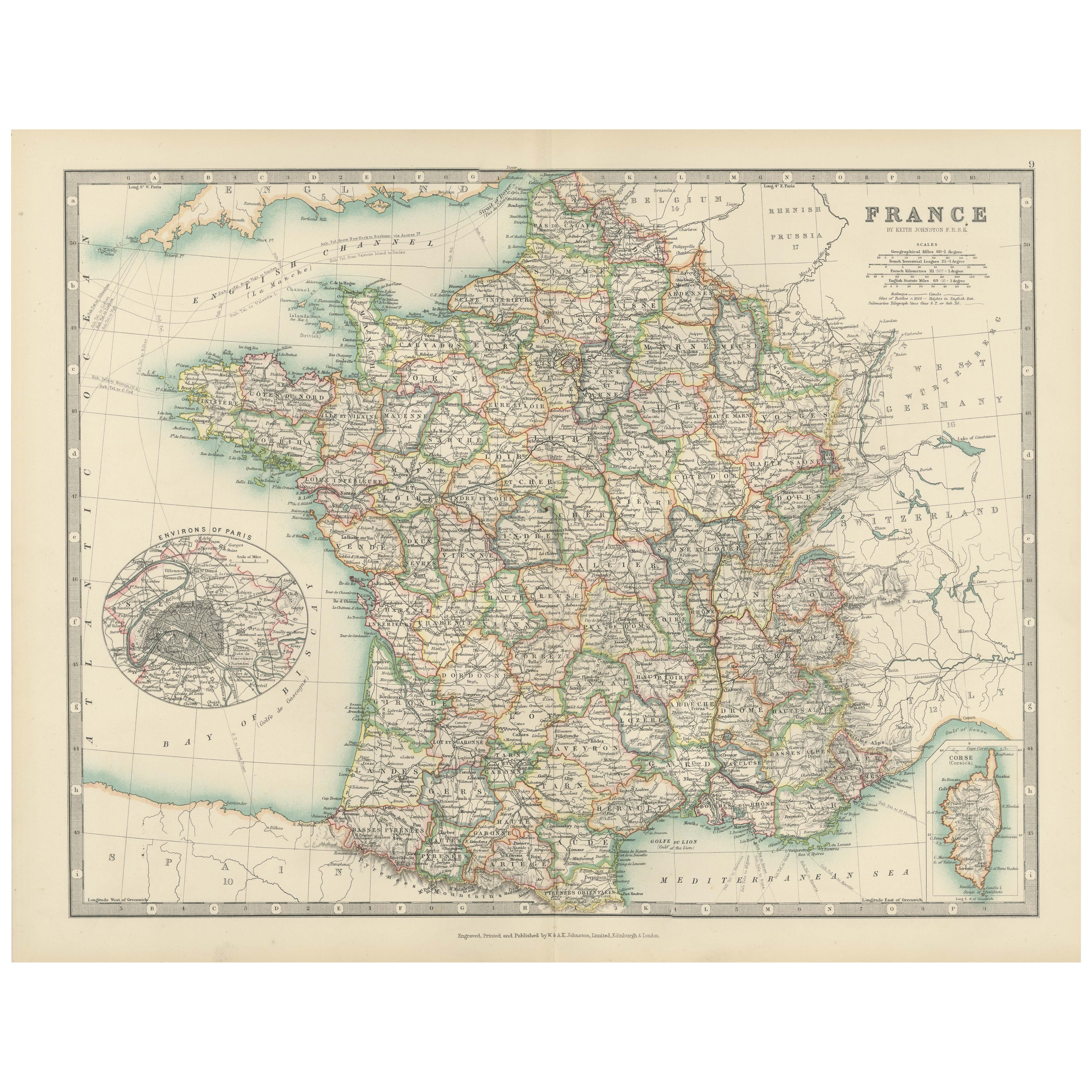
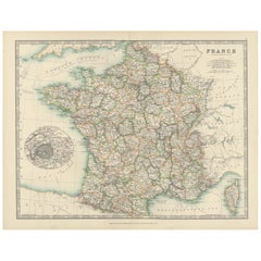
Mostra tuttoAntique Map of France, 1903, with Inset of Paris and Corsica
Title: Antique Map of France, 1903, with Inset of Paris and Corsica
Description:
This antique map, titled "France," was engraved and published in 1903 by the renowned W. & A.K. John...
Categoria
Inizio XX secolo, Mappe
Materiali
Carta
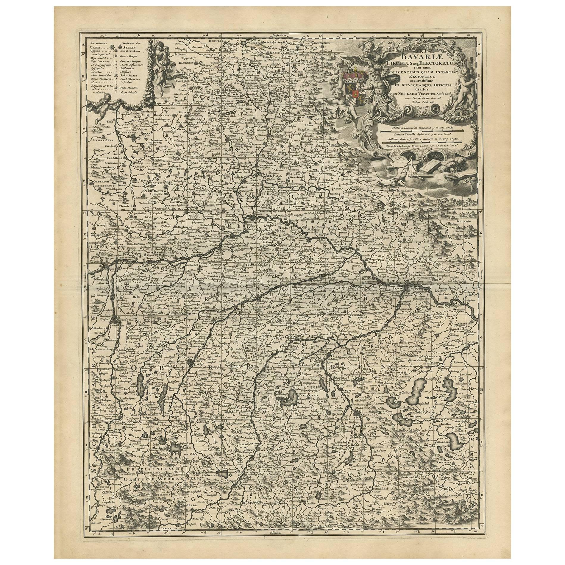
Carta geografica antica della Baviera con molti dettagli, Germania
Carta geografica antica intitolata "Bavariae Circulus atq Electoratus tam cum Adiacentibus quam insertis Regionibus (..)". Mappa olandese della Baviera, che mostra le numerose città,...
Categoria
Di antiquariato/d’epoca, Fine XVII secolo, Mappe
Materiali
Carta
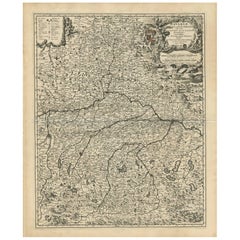
612 USD Prezzo promozionale
20% in meno
Carta geografica antica della Grecia con inserto della regione del Danubio superiore, 1720 ca.
Carta geografica antica intitolata "Fluviorum in Europa principis Danubii cum adiacentibus Regnis".
Mappa dettagliata della Grecia, dei Balcani e delle parti contigue dei mari Adri...
Categoria
Di antiquariato/d’epoca, XVIII secolo, Mappe
Materiali
Carta

695 USD Prezzo promozionale
20% in meno
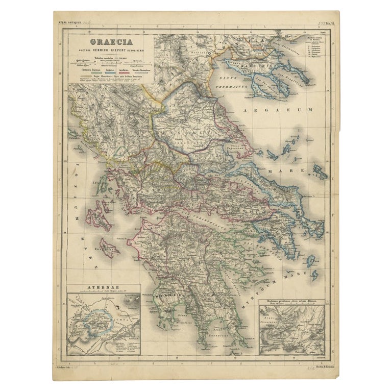
Mappa antica della Grecia con due piccoli inserti di Atene, 1870 ca.
Carta geografica antica intitolata "Graecia". Carta geografica antica della Grecia con due piccoli inserti di Atene. Questa mappa proviene da "Atlas Antiquus, twaalf kaarten behooren...
Categoria
Di antiquariato/d’epoca, XIX secolo, Mappe
Materiali
Carta

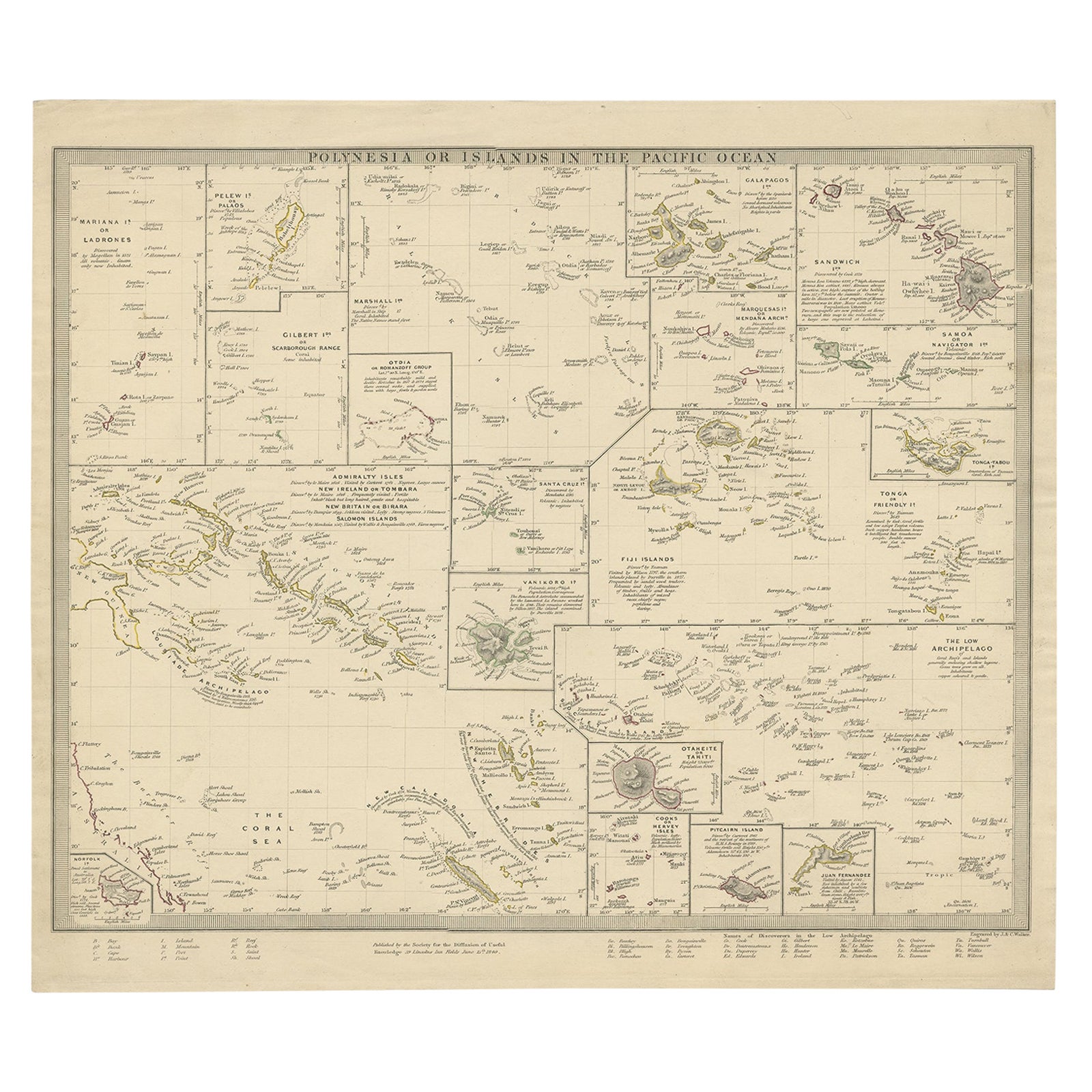
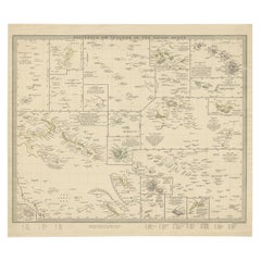
Mappa antica della Polinesia con dettagli di molte isole, 1840
Carta geografica antica intitolata "Polinesia o Isole dell'Oceano Pacifico".
Questa mappa raffigura varie isole tra cui l'Arcipelago delle Lousiadi, Tahiti, l'Isola Pitcairn, Juan ...
Categoria
Di antiquariato/d’epoca, XIX secolo, Mappe
Materiali
Carta
Antique Map of Southern Scotland, 1903, with Coastal and Inland Details
Title: Antique Map of Southern Scotland, 1903, with Coastal and Inland Details
Description:
This exquisite antique map, titled "Scotland (Southern Sheet I)," was engraved and publis...
Categoria
Inizio XX secolo, Mappe
Materiali
Carta

Ti potrebbe interessare anche
Mappa antica originale dello Stato americano del Tennessee, 1903
Antique map of Tennessee
Published By A & C Black. 1903
Original colour
Good condition
Unframed.
Free shipping
Categoria
Di antiquariato/d’epoca, Inizio Novecento, Inglese, Mappe
Materiali
Carta

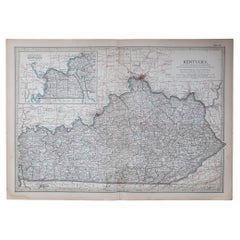
Mappa antica originale dello Stato americano del Kentucky, 1903
Mappa antica del Kentucky
Pubblicato da A.I.C. Black. 1903
Colore originale
Buono stato
Senza cornice.
Spedizione gratuita
Categoria
Di antiquariato/d’epoca, Inizio Novecento, Inglese, Mappe
Materiali
Carta
Mappa antica originale dello Stato americano del Mississippi, 1903
Mappa antica del Mississippi
Pubblicato da A.I.C. Black. 1903
Colore originale
Buono stato
Senza cornice.
Spedizione gratuita
Categoria
Di antiquariato/d’epoca, Inizio Novecento, Inglese, Mappe
Materiali
Carta

Mappa antica originale dello Stato americano del Massachusetts, 1903
Antique map of Vermont and New Hampshire
Published By A & C Black. 1903
Original colour
Good condition
Unframed.
Free shipping
Categoria
Di antiquariato/d’epoca, Inizio Novecento, Inglese, Mappe
Materiali
Carta

Mappa antica originale dello Stato americano dell'Alabama, 1903
Antique map of Alabama
Published By A & C Black. 1903
Original colour
Good condition
Unframed.
Free shipping
Categoria
Di antiquariato/d’epoca, Inizio Novecento, Inglese, Mappe
Materiali
Carta

Mappa antica originale dello Stato americano della Louisiana, 1903
Mappa antica della Louisiana
Pubblicato da A.I.C. Black. 1903
Colore originale
Buono stato
Senza cornice.
Spedizione gratuita
Categoria
Di antiquariato/d’epoca, Inizio Novecento, Inglese, Mappe
Materiali
Carta
