Articoli simili a Antique Map of Ireland, 1903, with Intricate County Boundaries & Coastal Details


Vuoi altre immagini o video?
Richiedi altre immagini o video al venditore
1 di 10
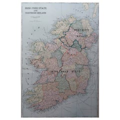
Antique Map of Ireland, 1903, with Intricate County Boundaries & Coastal Details
Informazioni sull’articolo
Title: Antique Map of Ireland, 1903, with Intricate County Boundaries and Coastal Detail
Description:
This antique map of Ireland, engraved and published in 1903 by the esteemed W. & A.K. Johnston firm in Edinburgh and London, is a beautifully detailed portrayal of the Emerald Isle. It offers a fascinating snapshot of Ireland’s political and geographical landscape at the turn of the 20th century.
The map captures the entire island of Ireland with exceptional clarity, extending from the rugged coastlines of Donegal in the north to the sun-warmed shores of Cork and Kerry in the south. Delicately colored in soft pastels of green, pink, and yellow, it highlights the various counties and their administrative boundaries. Rivers, mountain ranges, and major cities such as Dublin, Belfast, and Cork are all meticulously documented, reflecting the cartographic precision of Johnston’s work.
Of particular interest are the intricate networks of railways and roads that connect the towns and villages, illustrating the early 20th-century infrastructure that helped shape the social and economic fabric of Ireland. The inclusion of historical province names—Ulster, Leinster, Munster, and Connaught—adds an extra layer of cultural context, evoking Ireland’s rich and complex history.
For collectors, historians, and lovers of Irish heritage, this map is more than just a beautiful artifact. It is a tangible record of Ireland during a time of significant social and political change, just before the transformative events of the Irish struggle for independence. Its soft coloring and fine engraving make it a stunning decorative piece that also sparks historical curiosity.
Condition report:
The map is in very good antique condition, with minor age-related foxing and slight edge toning typical for its vintage. The colors remain vibrant and the paper is stable and well-preserved.
Framing tips:
A classic wooden frame in walnut or oak will bring warmth and elegance to this map. Pair with a cream or off-white matting to accentuate the pastel coloring and delicate detail, creating a timeless and sophisticated display perfect for any home or office.
- Dimensioni:Altezza: 36,8 cm (14,49 in)Larghezza: 48 cm (18,9 in)Profondità: 0,2 mm (0,01 in)
- Materiali e tecniche:
- Periodo:
- Data di produzione:1903
- Condizioni:The map is in very good antique condition, with minor age-related foxing and slight edge toning typical for its vintage. The colors remain vibrant and the paper is stable and well-preserved. Folding line as issued.
- Località del venditore:Langweer, NL
- Numero di riferimento:Venditore: BG-13577-81stDibs: LU3054345241432
Informazioni sul venditore
5,0
Venditore riconosciuto
Questi venditori prestigiosi sono leader del settore e rappresentano il massimo in termini di qualità e design.
Venditore Oro
Venditori Premium con valutazione 4,3+ e tempi di risposta entro 24 ore
Fondazione nel 2009
Venditore 1stDibs dal 2017
2.452 vendite su 1stDibs
Tempo di risposta standard: <1 ora
- SpedizioneRecupero del preventivo…Spedizione da: Langweer, Paesi Bassi
- Politica di reso
Alcune parti di questa pagina sono state tradotte automaticamente. 1stDibs non può garantire che le traduzioni siano corrette. L’inglese è la lingua predefinita del sito.
Garanzia di autenticità
Nell’improbabile caso in cui si verifichi un problema con l’autenticità di un articolo, contattaci entro un anno per ottenere un rimborso completo. DettagliGaranzia di rimborso
Se il tuo articolo non corrisponde alla descrizione, è danneggiato durante il trasporto o non arriva, contattaci entro 7 giorni per un rimborso completo. DettagliAnnullamento entro 24 ore
Hai un periodo di tolleranza di 24 ore per annullare il tuo acquisto, senza necessità di fornire spiegazioni.Venditori professionali selezionati
I nostri venditori di livello internazionale devono aderire a rigorosi standard di servizio e qualità, garantendo l’integrità delle inserzioni.Garanzia miglior prezzo
Se scopri che un venditore ha pubblicato altrove lo stesso articolo a un prezzo più basso, applicheremo lo stesso prezzo.Consegna globale affidabile
La nostra rete di vettori leader del settore offre opzioni di spedizione specializzate in tutto il mondo, inclusa la consegna personalizzata.Altro da questo venditore
Mostra tuttoAntique Map of Europe, 1903, with Intricate Political Boundaries and Rich Detail
Title: Antique Map of Europe, 1903, with Intricate Political Boundaries and Rich Detail
Description:
This antique map, titled "Europe," is a finely engraved and beautifully colored ...
Categoria
Inizio XX secolo, Mappe
Materiali
Carta

Antique Map of Asia with Intricate Provincial Boundaries, Published in 1903
Title: Antique Map of Asia, 1903, with Intricate Provincial Boundaries and Coastal Features
Description:
This antique map, titled "Asia," was engraved and published in 1903 by the r...
Categoria
Inizio XX secolo, Mappe
Materiali
Carta

Antique Map of the German Empire, 1903, with Intricate Provincial Boundaries
Title: Antique Map of the German Empire, 1903, with Intricate Provincial Boundaries
Description:
This antique map, titled "Empire of Germany (Southern Portion)," was engraved and pu...
Categoria
Inizio XX secolo, Mappe
Materiali
Carta

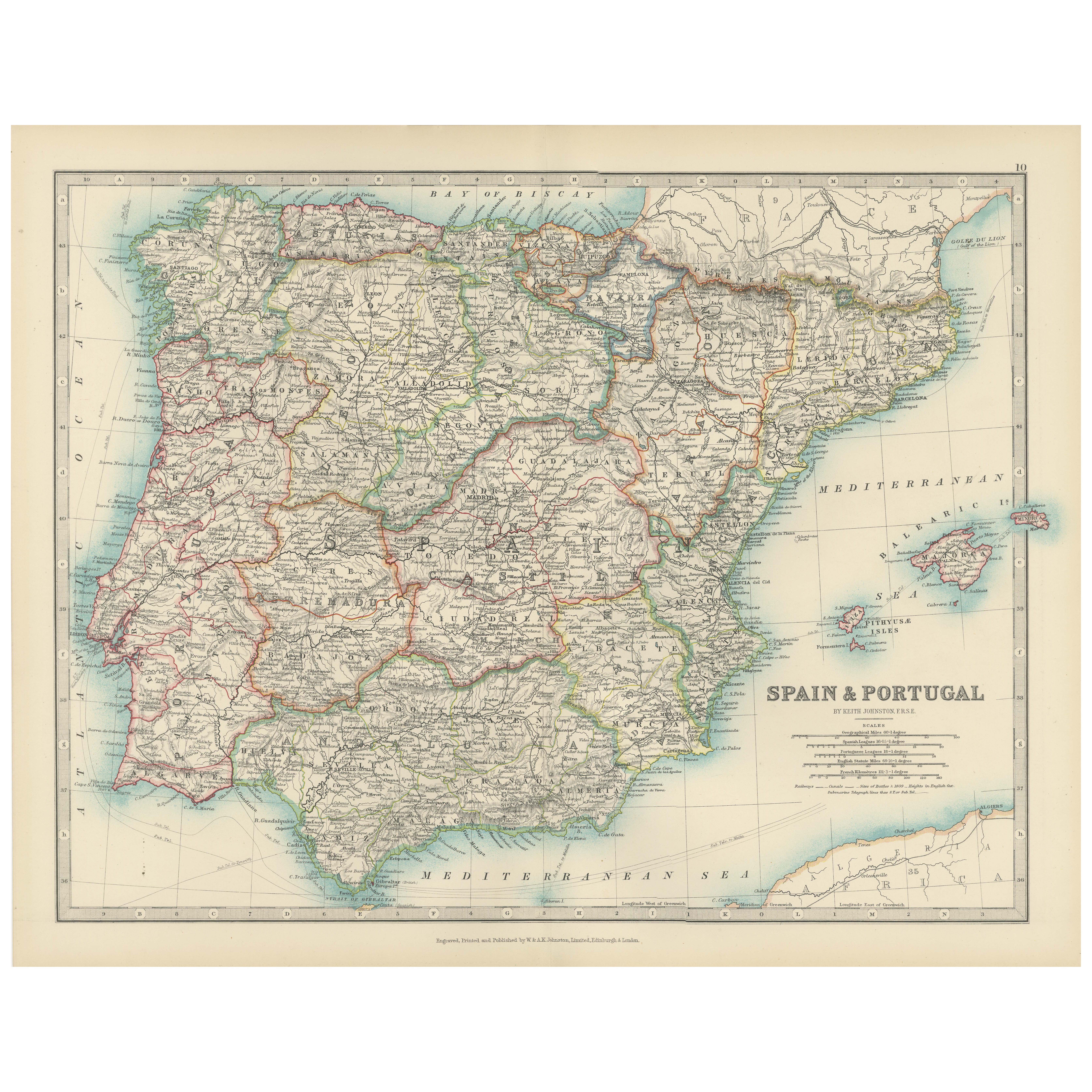
Antique Map of Spain and Portugal, 1903, Regional Boundaries and Coastal Detail
Antique Map of Spain and Portugal, 1903, Featuring Regional Boundaries and Coastal Detail
Description: This antique map, titled "Spain & Portugal," was engraved and published in 190...
Categoria
Inizio XX secolo, Mappe
Materiali
Carta
Antique Map of Northern Scotland, 1903, with Intricate Coastal Features
Title: Antique Map of Northern Scotland and Islands, 1903, with Intricate Coastal Features
Description:
This striking antique map, titled "Scotland (Northern Sheet I)," was engraved...
Categoria
Inizio XX secolo, Mappe
Materiali
Carta

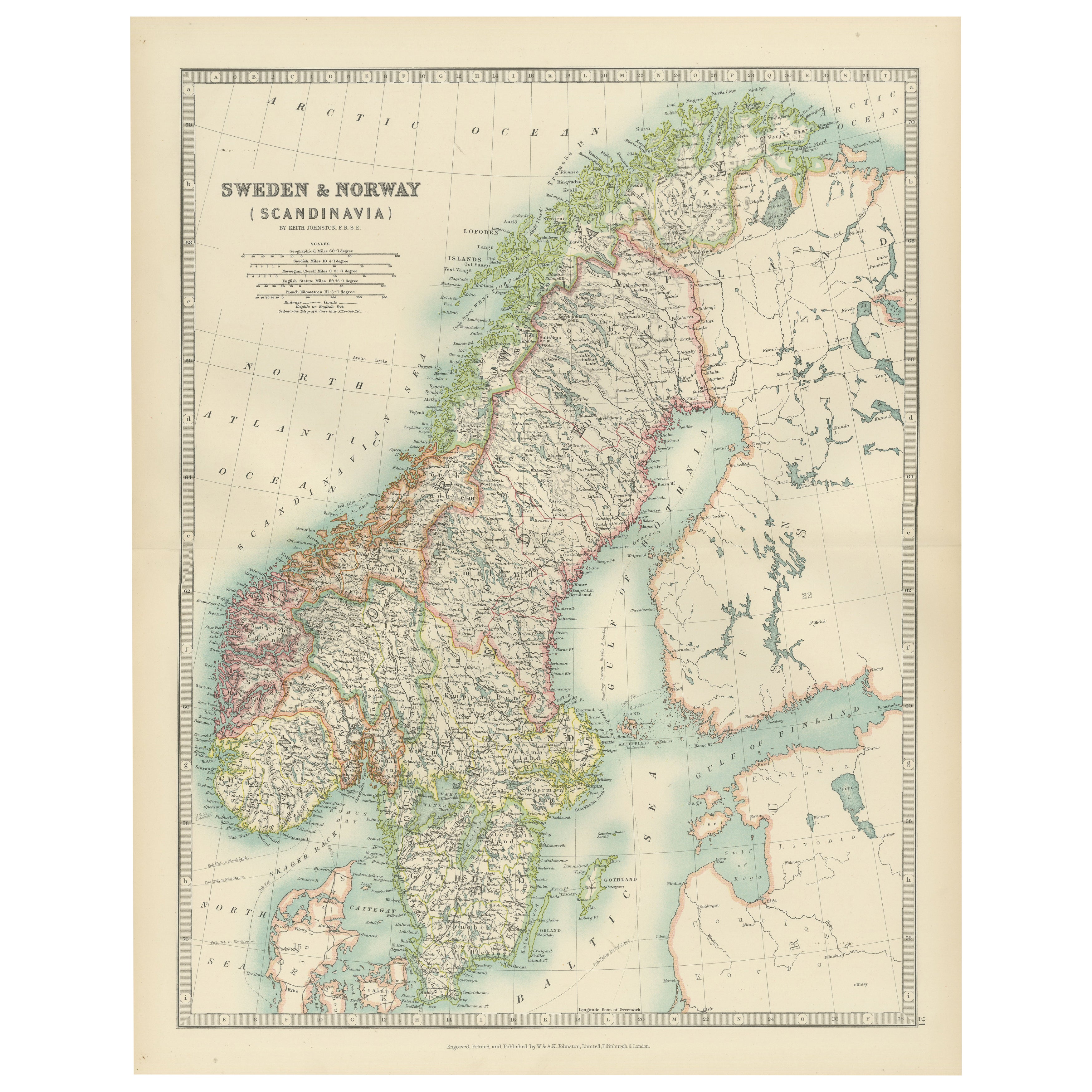
Antique Map of Sweden & Norway, 1903, with Intricate Topographical Detail
Title: Antique Map of Sweden & Norway, 1903, with Intricate Topographical Detail
Description:
This antique map, titled "Sweden & Norway (Scandinavia)," was engraved and published in...
Categoria
Inizio XX secolo, Mappe
Materiali
Carta
Ti potrebbe interessare anche
Mappa antica originale dell'Irlanda - Kerry. C.1840
Ottima mappa del Kerry
Incisione in acciaio
Disegnato sotto la direzione di A.Adlard
Pubblicato da How e Parsons, 1840 ca.
Senza cornice.
Categoria
Di antiquariato/d’epoca, Anni 1840, Inglese, Mappe
Materiali
Carta

Grande mappa antica originale dell'Irlanda. C.1900
Favolosa mappa dell'Irlanda
Colore originale.
Inciso e stampato dalla George F. Cram Company, Indianapolis.
Pubblicato, C.1900.
Senza cornice.
Spedizione gratuita.
Categoria
Di antiquariato/d’epoca, Anni 1890, Americano, Mappe
Materiali
Carta
Mappa antica originale dello Stato americano del Minnesota, 1903
Mappa antica del Minnesota
Pubblicato da A.I.C. Black. 1903
Colore originale
Buono stato
Senza cornice.
Spedizione gratuita
Categoria
Di antiquariato/d’epoca, Inizio Novecento, Inglese, Mappe
Materiali
Carta

Mappa antica originale dello Stato americano dell'Alabama, 1903
Antique map of Alabama
Published By A & C Black. 1903
Original colour
Good condition
Unframed.
Free shipping
Categoria
Di antiquariato/d’epoca, Inizio Novecento, Inglese, Mappe
Materiali
Carta

Mappa antica originale dello Stato americano dell'Alaska, 1903
Mappa antica dell'Alaska
Pubblicato da A.I.C. Black. 1903
Colore originale
Buono stato
Senza cornice.
Spedizione gratuita
Categoria
Di antiquariato/d’epoca, Inizio Novecento, Inglese, Mappe
Materiali
Carta

Mappa antica originale dello Stato americano del Nebraska, 1903
Mappa antica del Nebraska
Pubblicato da A.I.C. Black. 1903
Colore originale
Buono stato
Senza cornice.
Spedizione gratuita
Categoria
Di antiquariato/d’epoca, Inizio Novecento, Inglese, Mappe
Materiali
Carta
