Articoli simili a Antique Map of Oceania, 1903, Featuring the Pacific Islands and Australasia


Vuoi altre immagini o video?
Richiedi altre immagini o video al venditore
1 di 10
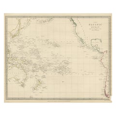
Antique Map of Oceania, 1903, Featuring the Pacific Islands and Australasia
Informazioni sull’articolo
Title: Antique Map of Oceania, 1903, Featuring the Pacific Islands and Australasian Region
Description:
This antique map, titled "Oceania," was engraved and published in 1903 by W. & A.K. Johnston in Edinburgh and London. It provides a comprehensive and visually captivating depiction of the vast and culturally diverse region that includes the islands of the Pacific Ocean, as well as Australia and New Zealand.
Hand-colored in soft pastel shades, the map highlights the political and geographical boundaries of the region at the turn of the 20th century. The major landmasses of Australia, New Zealand, and the Indonesian archipelago are rendered with careful detail, while the islands of Micronesia, Melanesia, and Polynesia—scattered across the Pacific—are marked with precision and clarity.
This map captures not just the geography, but also the maritime networks and colonial ambitions that defined the region at the dawn of the modern era. Trade routes, ocean currents, and key ports are included, emphasizing the interconnectedness of these far-flung lands with the broader world.
For collectors, historians, and those with a passion for the history of exploration and the rich cultures of the Pacific, this map is a window into a time when distant islands and ancient cultures were coming into closer contact with the rest of the globe. The refined engraving and soft colors of the map also make it a striking decorative piece.
Condition report:
This map is in very good antique condition, with minor foxing and gentle edge toning typical for its age. The colors remain vibrant and the paper is stable and well-preserved.
Framing tips:
A classic dark wood frame in walnut or cherry will enhance the pastel colors and maritime elegance of the map. Use a cream or off-white matting to highlight the intricate linework and create a sophisticated, timeless focal point in any home, study, or library.
- Dimensioni:Altezza: 36,8 cm (14,49 in)Larghezza: 47 cm (18,51 in)Profondità: 0,2 mm (0,01 in)
- Materiali e tecniche:
- Periodo:
- Data di produzione:1903
- Condizioni:This map is in very good antique condition, with minor foxing and gentle edge toning typical for its age. The colors remain vibrant and the paper is stable and well-preserved. Folding line as issued.
- Località del venditore:Langweer, NL
- Numero di riferimento:Venditore: BG-13577-311stDibs: LU3054345262762
Informazioni sul venditore
5,0
Venditore riconosciuto
Questi venditori prestigiosi sono leader del settore e rappresentano il massimo in termini di qualità e design.
Venditore Oro
Venditori Premium con valutazione 4,3+ e tempi di risposta entro 24 ore
Fondazione nel 2009
Venditore 1stDibs dal 2017
2.452 vendite su 1stDibs
Tempo di risposta standard: <1 ora
- SpedizioneRecupero del preventivo…Spedizione da: Langweer, Paesi Bassi
- Politica di reso
Alcune parti di questa pagina sono state tradotte automaticamente. 1stDibs non può garantire che le traduzioni siano corrette. L’inglese è la lingua predefinita del sito.
Garanzia di autenticità
Nell’improbabile caso in cui si verifichi un problema con l’autenticità di un articolo, contattaci entro un anno per ottenere un rimborso completo. DettagliGaranzia di rimborso
Se il tuo articolo non corrisponde alla descrizione, è danneggiato durante il trasporto o non arriva, contattaci entro 7 giorni per un rimborso completo. DettagliAnnullamento entro 24 ore
Hai un periodo di tolleranza di 24 ore per annullare il tuo acquisto, senza necessità di fornire spiegazioni.Venditori professionali selezionati
I nostri venditori di livello internazionale devono aderire a rigorosi standard di servizio e qualità, garantendo l’integrità delle inserzioni.Garanzia miglior prezzo
Se scopri che un venditore ha pubblicato altrove lo stesso articolo a un prezzo più basso, applicheremo lo stesso prezzo.Consegna globale affidabile
La nostra rete di vettori leader del settore offre opzioni di spedizione specializzate in tutto il mondo, inclusa la consegna personalizzata.Altro da questo venditore
Mostra tuttoAntique Map of Italy, 1903, Featuring Islands of Sardinia and Sicily
Title: Antique Map of Italy, 1903, Featuring Islands of Sardinia and Sicily
Description:
This finely detailed antique map, titled "Italy," was engraved and published in 1903 by the ...
Categoria
Inizio XX secolo, Mappe
Materiali
Carta
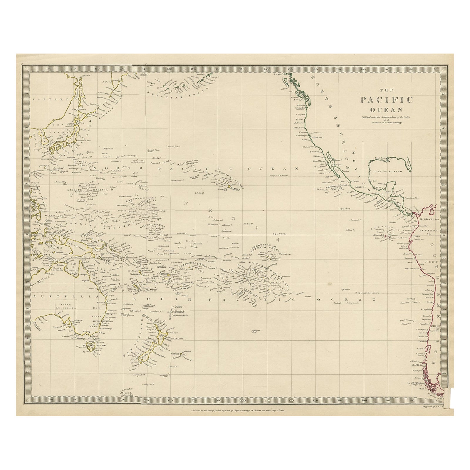
Carta geografica antica dell'Australasia, della Nuova Zelanda, della Polinesia e dell'Oceano Pacifico, 1840
Mappa antica intitolata "L'Oceano Pacifico".
Questa mappa raffigura l'Australasia, la Nuova Zelanda, la Polinesia e le isole dell'Oceano Pacifico, comprese le Isole Sandwich.
...
Categoria
Di antiquariato/d’epoca, Anni 1840, Mappe
Materiali
Abalone, Carta
205 USD Prezzo promozionale
20% in meno
Antique Map of New Zealand, 1903, Featuring the North and South Islands and Alps
Title: Antique Map of New Zealand, 1903, Featuring the North and South Islands and the Southern Alps
Description:
This antique map, titled "New Zealand," was engraved and published ...
Categoria
Inizio XX secolo, Mappe
Materiali
Carta

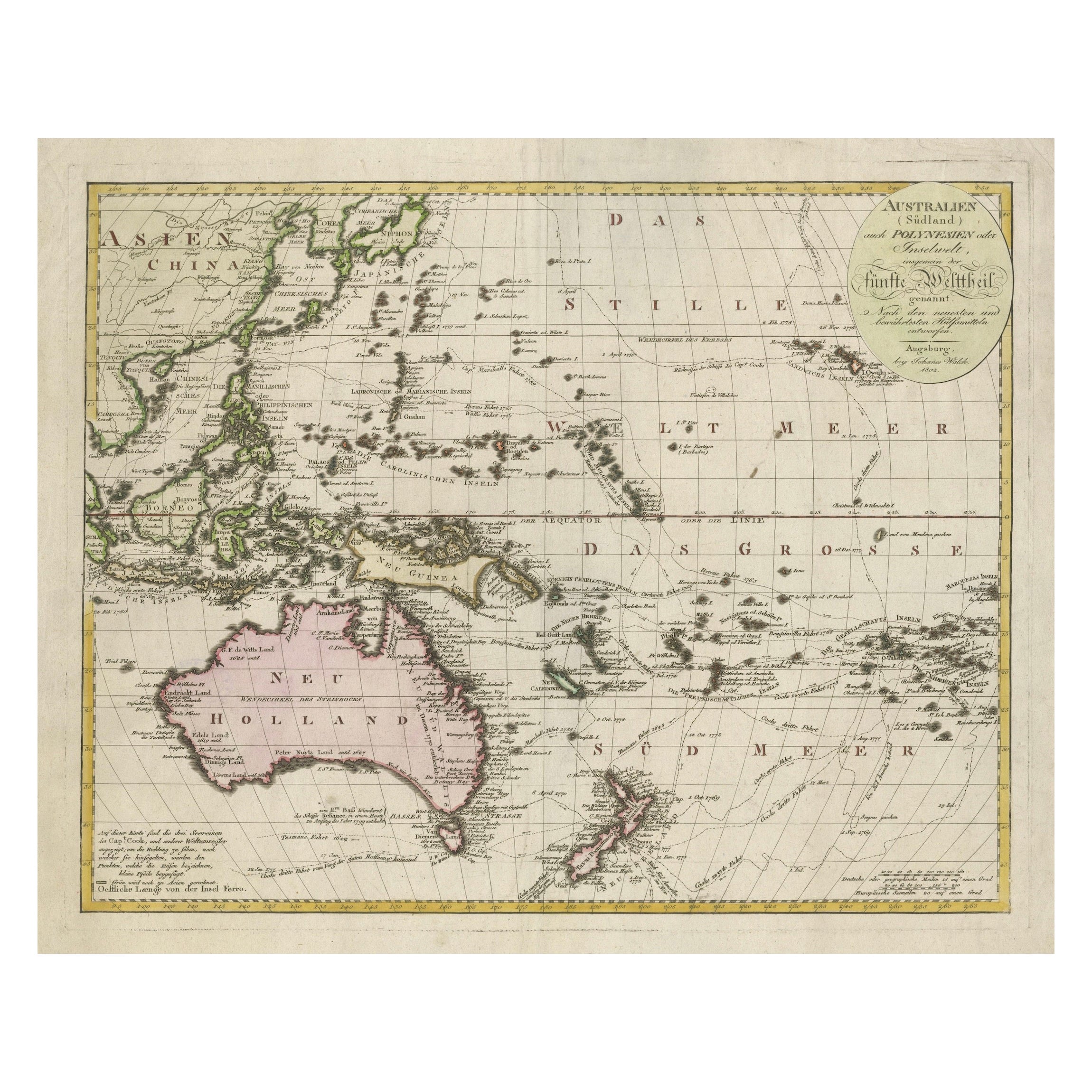
Mappa dell'Australasia e del Pacifico meridionale del 1802 - Rotte di esplorazione europee
1802 Johann Walch Mappa dell'Australasia e del Pacifico meridionale - Rotte di esplorazione europee
Questa mappa del 1802 di Johann Walch offre una visione estremamente dettagliata ...
Categoria
Di antiquariato/d’epoca, Inizio Ottocento, Mappe
Materiali
Carta
1.680 USD Prezzo promozionale
20% in meno
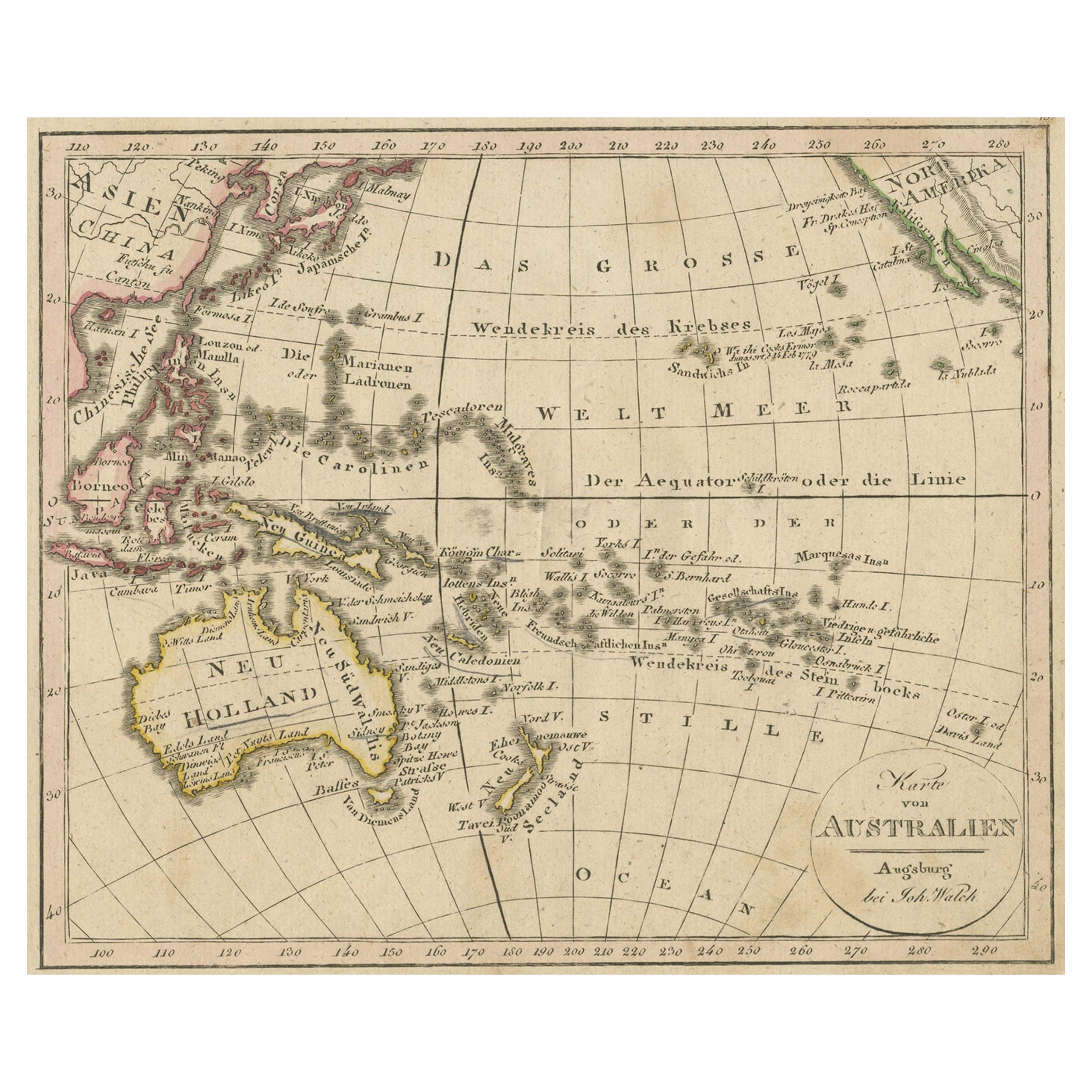
Mappa antica dell'Oceania e dell'Oceano Pacifico, Australia e Nuova Zelanda, 1826
Carta geografica antica dell'Australia intitolata "Karte von Australien". Vecchia mappa dell'Australia e della Nuova Zelanda. Pubblicato nel "Neuester Schul-Atlas" di Walch.
Arti...
Categoria
Di antiquariato/d’epoca, XIX secolo, Mappe
Materiali
Carta
149 USD Prezzo promozionale
20% in meno
Mappa antica delle isole dell'Oceano Pacifico di Wyld, "1845
Mappa antica intitolata "Isole dell'Oceano Pacifico". Mappa antica originale delle isole dell'Oceano Pacifico. Questa mappa proviene da "Un Atlante del Mondo, comprendente mappe sepa...
Categoria
Di antiquariato/d’epoca, Metà XIX secolo, Mappe
Materiali
Carta

186 USD Prezzo promozionale
20% in meno
Ti potrebbe interessare anche
Mappa antica originale dello Stato americano del Connecticut e del Rhode Island, 1903
Antique map of Connecticut and Rhode Island
Published By A & C Black. 1903
Original colour
Good condition
Unframed.
Free shipping
Categoria
Di antiquariato/d’epoca, Inizio Novecento, Inglese, Mappe
Materiali
Carta

49 USD
Spedizione gratuita
Grande mappa originale d'epoca delle isole del Pacifico, comprese le Hawaii
Grande mappa delle isole del Pacifico
Non incorniciato
Colore originale
Da John Bartholomew and Co. Istituto Geografico di Edimburgo
Pubblicato, circa 1920
Spedizione ...
Categoria
Vintage, Anni 1920, Britannico, Mappe
Materiali
Carta

45 USD
Spedizione gratuita
Mappa antica originale dello Stato americano del Minnesota, 1903
Mappa antica del Minnesota
Pubblicato da A.I.C. Black. 1903
Colore originale
Buono stato
Senza cornice.
Spedizione gratuita
Categoria
Di antiquariato/d’epoca, Inizio Novecento, Inglese, Mappe
Materiali
Carta

Mappa antica originale dello Stato americano dell'Alabama, 1903
Antique map of Alabama
Published By A & C Black. 1903
Original colour
Good condition
Unframed.
Free shipping
Categoria
Di antiquariato/d’epoca, Inizio Novecento, Inglese, Mappe
Materiali
Carta

Mappa antica originale dello Stato americano dell'Alaska, 1903
Mappa antica dell'Alaska
Pubblicato da A.I.C. Black. 1903
Colore originale
Buono stato
Senza cornice.
Spedizione gratuita
Categoria
Di antiquariato/d’epoca, Inizio Novecento, Inglese, Mappe
Materiali
Carta

Mappa antica originale dello Stato americano del Nebraska, 1903
Mappa antica del Nebraska
Pubblicato da A.I.C. Black. 1903
Colore originale
Buono stato
Senza cornice.
Spedizione gratuita
Categoria
Di antiquariato/d’epoca, Inizio Novecento, Inglese, Mappe
Materiali
Carta
