Articoli simili a Antique Map of Southern Scotland, 1903, with Coastal and Inland Details


Vuoi altre immagini o video?
Richiedi altre immagini o video al venditore
1 di 10
Antique Map of Southern Scotland, 1903, with Coastal and Inland Details
Informazioni sull’articolo
Title: Antique Map of Southern Scotland, 1903, with Coastal and Inland Details
Description:
This exquisite antique map, titled "Scotland (Southern Sheet I)," was engraved and published in 1903 by the esteemed W. & A.K. Johnston firm in Edinburgh and London. A testament to early 20th-century cartography, it meticulously documents the southern half of Scotland, including its rugged coastlines and bustling cities.
The map’s elegant pastel coloring in soft greens, pinks, and yellows delineates county boundaries and enhances the intricate topographical features, from mountain ranges and lochs to rivers and valleys. Major cities such as Edinburgh and Glasgow are clearly marked, along with smaller towns, railway lines, and maritime routes that showcase the region’s vibrant economy during the industrial era.
One of the highlights is the beautifully depicted Hebrides, nestled off the western coast in the Atlantic Ocean. The map’s clarity and precision extend to the smallest islands, reflecting the meticulous craftsmanship of Johnston’s engravers and their dedication to accuracy.
For collectors, historians, and enthusiasts of Scottish heritage, this map provides a window into the past, illustrating a landscape shaped by centuries of cultural and economic evolution. It also highlights the natural beauty of the Highlands and Lowlands, capturing the distinct character of Scotland’s south with an artistry that resonates even today.
Condition report:
This map is in very good antique condition, showing slight toning and minimal foxing around the edges typical for its age. The color palette remains vibrant and the paper stable and clear.
Framing tips:
A classic dark wood frame in walnut or mahogany will enhance the warm pastel tones and intricate detail of this map. A light cream or ivory matting will further highlight the delicate coloring and provide an elegant presentation, making this piece a refined focal point for any home or office space.
- Dimensioni:Altezza: 36,8 cm (14,49 in)Larghezza: 48 cm (18,9 in)Profondità: 0,2 mm (0,01 in)
- Materiali e tecniche:
- Periodo:
- Data di produzione:1903
- Condizioni:This map is in very good antique condition, showing slight toning and minimal foxing around the edges typical for its age. The color palette remains vibrant and the paper stable and clear. Folding line as issued.
- Località del venditore:Langweer, NL
- Numero di riferimento:Venditore: BG-13577-71stDibs: LU3054345241392
Informazioni sul venditore
5,0
Venditore riconosciuto
Questi venditori prestigiosi sono leader del settore e rappresentano il massimo in termini di qualità e design.
Venditore Oro
Venditori Premium con valutazione 4,3+ e tempi di risposta entro 24 ore
Fondazione nel 2009
Venditore 1stDibs dal 2017
2.446 vendite su 1stDibs
Tempo di risposta standard: 1 ora
- SpedizioneRecupero del preventivo…Spedizione da: Langweer, Paesi Bassi
- Politica di reso
Alcune parti di questa pagina sono state tradotte automaticamente. 1stDibs non può garantire che le traduzioni siano corrette. L’inglese è la lingua predefinita del sito.
Garanzia di autenticità
Nell’improbabile caso in cui si verifichi un problema con l’autenticità di un articolo, contattaci entro un anno per ottenere un rimborso completo. DettagliGaranzia di rimborso
Se il tuo articolo non corrisponde alla descrizione, è danneggiato durante il trasporto o non arriva, contattaci entro 7 giorni per un rimborso completo. DettagliAnnullamento entro 24 ore
Hai un periodo di tolleranza di 24 ore per annullare il tuo acquisto, senza necessità di fornire spiegazioni.Venditori professionali selezionati
I nostri venditori di livello internazionale devono aderire a rigorosi standard di servizio e qualità, garantendo l’integrità delle inserzioni.Garanzia miglior prezzo
Se scopri che un venditore ha pubblicato altrove lo stesso articolo a un prezzo più basso, applicheremo lo stesso prezzo.Consegna globale affidabile
La nostra rete di vettori leader del settore offre opzioni di spedizione specializzate in tutto il mondo, inclusa la consegna personalizzata.Altro da questo venditore
Mostra tuttoAntique Map of Southern England & Wales, 1903, with Coastal Details and Railways
Title: Antique Map of Southern England and Wales, 1903, with Coastal Details and Railways
Description:
This detailed antique map, titled "England and Wales (Southern Sheet I)," was ...
Categoria
Inizio XX secolo, Mappe
Materiali
Carta
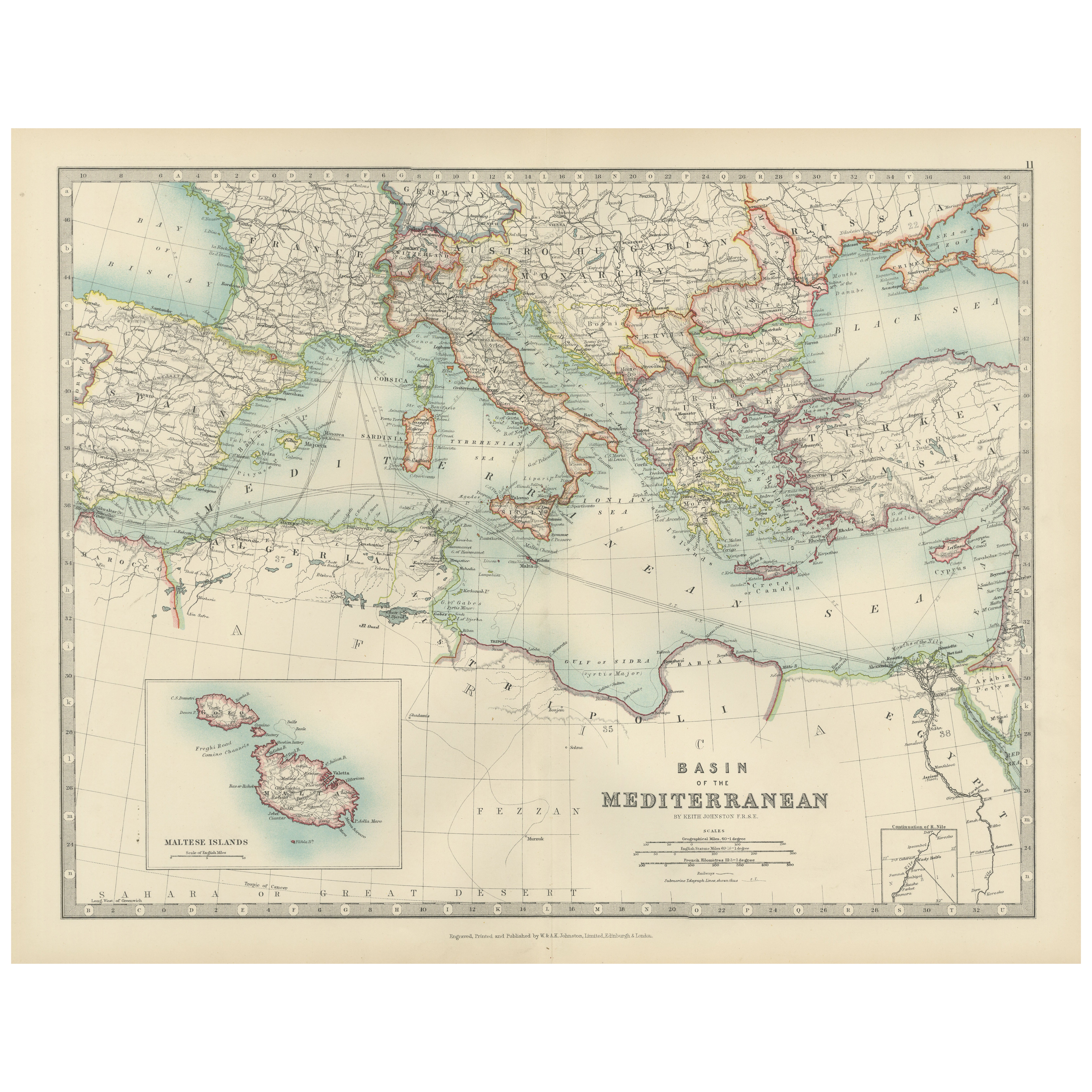
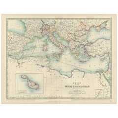
Antique Map of the Mediterranean Basin, 1903, with Detailed Coastal and Inland
Title: Antique Map of the Mediterranean Basin, 1903, with Detailed Coastal and Inland Geography
Description: This antique map, titled "Basin of the Mediterranean," was engraved and ...
Categoria
Inizio XX secolo, Mappe
Materiali
Carta
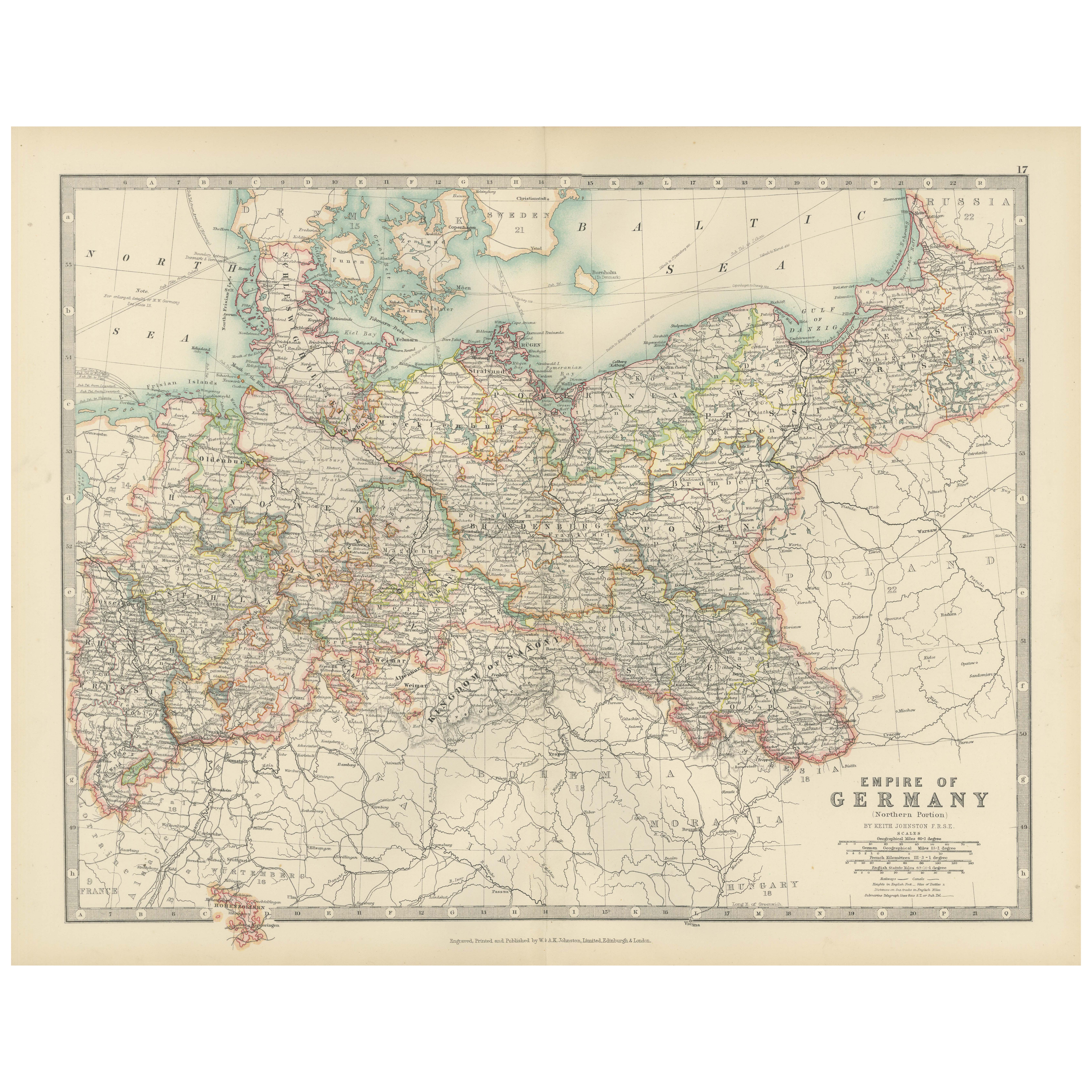
Antique Map of the German Empire, 1903, Northern Portion with Coastal and Inland
Title: Antique Map of the German Empire, 1903, Northern Portion with Coastal and Inland Detail
Description:
This antique map, titled "Empire of Germany (Northern Portion)," was engr...
Categoria
Inizio XX secolo, Mappe
Materiali
Carta

Antique Map of Northern Scotland, 1903, with Intricate Coastal Features
Title: Antique Map of Northern Scotland and Islands, 1903, with Intricate Coastal Features
Description:
This striking antique map, titled "Scotland (Northern Sheet I)," was engraved...
Categoria
Inizio XX secolo, Mappe
Materiali
Carta

Antique Map of Ireland, 1903, with Intricate County Boundaries & Coastal Details
Title: Antique Map of Ireland, 1903, with Intricate County Boundaries and Coastal Detail
Description:
This antique map of Ireland, engraved and published in 1903 by the esteemed W. ...
Categoria
Inizio XX secolo, Mappe
Materiali
Carta

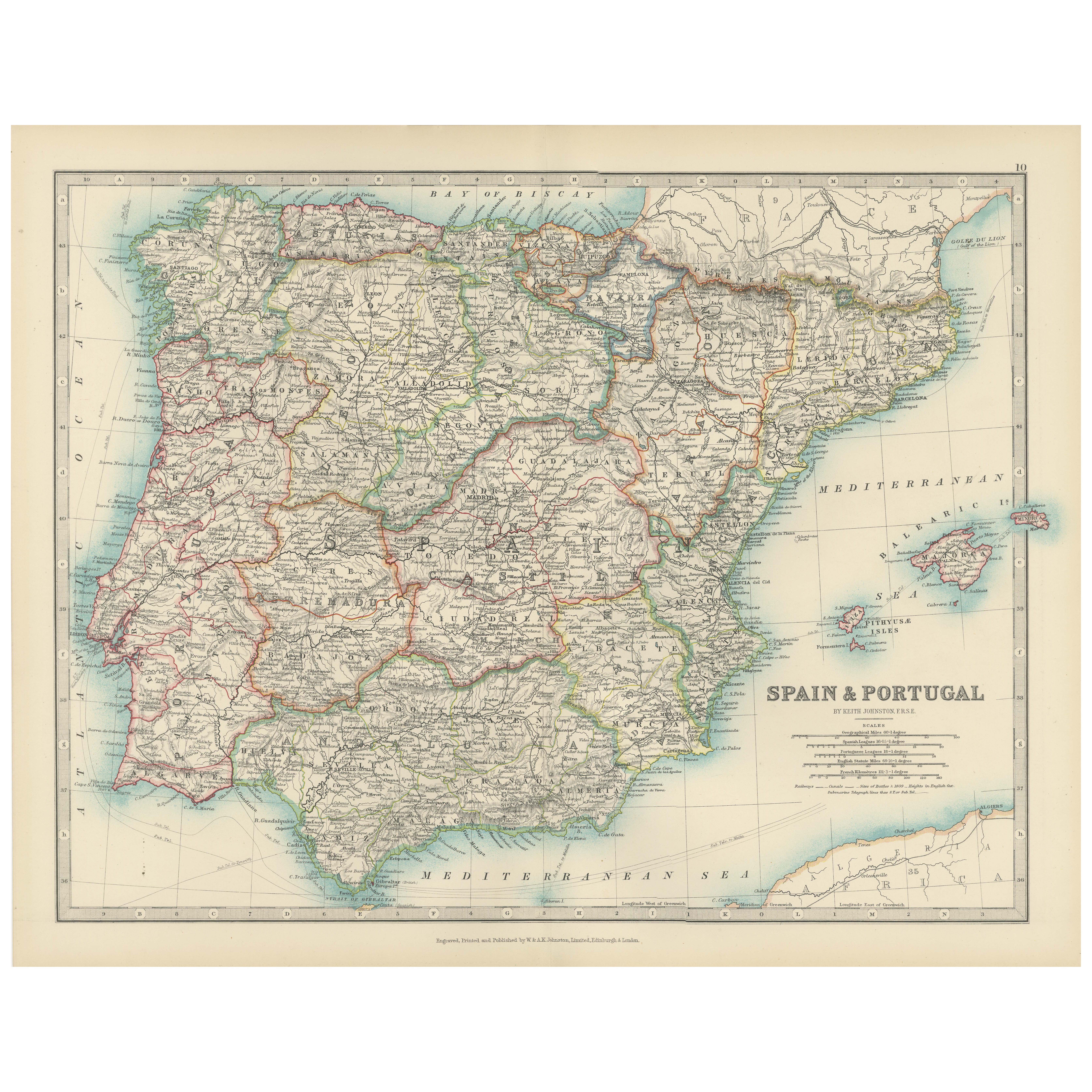
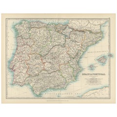
Antique Map of Spain and Portugal, 1903, Regional Boundaries and Coastal Detail
Antique Map of Spain and Portugal, 1903, Featuring Regional Boundaries and Coastal Detail
Description: This antique map, titled "Spain & Portugal," was engraved and published in 190...
Categoria
Inizio XX secolo, Mappe
Materiali
Carta
Ti potrebbe interessare anche
Mappa antica originale dello Stato americano del Missouri (parte meridionale), 1903
Carta geografica antica del Missouri (Parte meridionale)
Pubblicato da A.I.C. Black. 1903
Colore originale
Buono stato
Senza cornice.
Spedizione gratuita
Categoria
Di antiquariato/d’epoca, Inizio Novecento, Inglese, Mappe
Materiali
Carta

49 USD
Spedizione gratuita
Mappa antica originale dello Stato americano dell'Illinois (parte meridionale), 1903
Carta geografica antica dell'Illinois (parte meridionale)
Pubblicato da A.I.C. Black. 1903
Colore originale
Buono stato
Senza cornice.
Spedizione gratuita
Categoria
Di antiquariato/d’epoca, Inizio Novecento, Inglese, Mappe
Materiali
Carta

49 USD
Spedizione gratuita
Mappa antica originale dello Stato americano del Michigan (parte meridionale), 1903
Carta geografica antica del Michigan (parte meridionale)
Pubblicato da A.I.C. Black. 1903
Colore originale
Buono stato
Senza cornice.
Spedizione gratuita
Categoria
Di antiquariato/d’epoca, Inizio Novecento, Inglese, Mappe
Materiali
Carta

49 USD
Spedizione gratuita
Mappa antica originale dello Stato americano dell'Ohio (parte meridionale), 1903
Carta geografica antica dell'Ohio (parte meridionale)
Pubblicato da A.I.C. Black. 1903
Colore originale
Buono stato
Senza cornice.
Spedizione gratuita
Categoria
Di antiquariato/d’epoca, Inizio Novecento, Inglese, Mappe
Materiali
Carta

49 USD
Spedizione gratuita
Mappa antica originale dello Stato americano della California (parte meridionale), 1903
Carta geografica antica della California (parte meridionale)
Pubblicato da A.I.C. Black. 1903
Colore originale
Buono stato
Senza cornice.
Spedizione gratuita
Categoria
Di antiquariato/d’epoca, Inizio Novecento, Inglese, Mappe
Materiali
Carta

49 USD
Spedizione gratuita
Mappa antica originale dello Stato americano di New York (parte meridionale) 1903
Antique map of New York ( Southern Part )
Published By A & C Black. 1903
Original colour
Good condition
Unframed.
Free shipping
Categoria
Di antiquariato/d’epoca, Inizio Novecento, Inglese, Mappe
Materiali
Carta

49 USD
Spedizione gratuita