Articoli simili a Antique Map of Switzerland and the Alps of Savoy & Piedmont, 1903 Edition

Vuoi altre immagini o video?
Richiedi altre immagini o video al venditore
1 di 10
Antique Map of Switzerland and the Alps of Savoy & Piedmont, 1903 Edition
Informazioni sull’articolo
Title: Antique Map of Switzerland and the Alps of Savoy & Piedmont, 1903, with Intricate Topographical Detail
Description:
This beautifully engraved antique map, titled "Switzerland and the Alps of Savoy & Piedmont," was published in 1903 by the distinguished cartographic firm W. & A.K. Johnston in Edinburgh and London. It offers a stunning depiction of Switzerland and the adjacent alpine regions of Savoy and Piedmont, capturing the breathtaking beauty and complex topography of this iconic European landscape.
The map’s rich detailing combines elegant pastel coloring with delicate engraved lines to show political boundaries, mountain ranges, rivers, and lakes. Switzerland’s famous cities, such as Zurich, Geneva, and Bern, are clearly marked, along with major transportation routes and railway lines that were critical to the region’s development in the early 20th century. The map also extends to the picturesque French and Italian Alps, providing a comprehensive view of one of Europe’s most beloved mountain regions.
One of the most captivating features of this map is the intricate depiction of the Alps. The shading and linework convey the dramatic elevation changes, highlighting the grandeur and rugged beauty of the alpine peaks and valleys. This topographical precision not only makes the map a valuable historical document but also a striking work of art that captures the awe-inspiring landscape.
For collectors, historians, and lovers of alpine scenery, this map is a window into a time when Europe’s mountains were both a natural wonder and a symbol of national pride. It speaks to the era’s fascination with exploration, mountaineering, and the expanding infrastructure that brought these once-remote areas into closer connection with the world.
Condition report:
This map is in very good antique condition, showing minor foxing and slight toning along the edges typical for its age. The color remains vivid and the paper is well-preserved.
Framing tips:
A classic wooden frame in walnut or dark oak will complement the rich detail and warm pastel tones of this map. Use a cream or off-white matting to highlight the delicate topography and intricate linework, creating a refined and elegant centerpiece in any room or office.
- Dimensioni:Altezza: 36,8 cm (14,49 in)Larghezza: 48 cm (18,9 in)Profondità: 0,2 mm (0,01 in)
- Materiali e tecniche:
- Periodo:
- Data di produzione:1903
- Condizioni:The map is in very good antique condition, with minor age-related foxing and slight edge toning typical for its vintage. The colors remain vibrant and the paper is stable and well-preserved. Folding line as issued.
- Località del venditore:Langweer, NL
- Numero di riferimento:Venditore: BG-13577-131stDibs: LU3054345241962
Informazioni sul venditore
5,0
Venditore riconosciuto
Questi venditori prestigiosi sono leader del settore e rappresentano il massimo in termini di qualità e design.
Venditore Oro
Venditori Premium con valutazione 4,3+ e tempi di risposta entro 24 ore
Fondazione nel 2009
Venditore 1stDibs dal 2017
2.462 vendite su 1stDibs
Tempo di risposta standard: <1 ora
- SpedizioneRecupero del preventivo…Spedizione da: Langweer, Paesi Bassi
- Politica di reso
Alcune parti di questa pagina sono state tradotte automaticamente. 1stDibs non può garantire che le traduzioni siano corrette. L’inglese è la lingua predefinita del sito.
Garanzia di autenticità
Nell’improbabile caso in cui si verifichi un problema con l’autenticità di un articolo, contattaci entro un anno per ottenere un rimborso completo. DettagliGaranzia di rimborso
Se il tuo articolo non corrisponde alla descrizione, è danneggiato durante il trasporto o non arriva, contattaci entro 7 giorni per un rimborso completo. DettagliAnnullamento entro 24 ore
Hai un periodo di tolleranza di 24 ore per annullare il tuo acquisto, senza necessità di fornire spiegazioni.Venditori professionali selezionati
I nostri venditori di livello internazionale devono aderire a rigorosi standard di servizio e qualità, garantendo l’integrità delle inserzioni.Garanzia miglior prezzo
Se scopri che un venditore ha pubblicato altrove lo stesso articolo a un prezzo più basso, applicheremo lo stesso prezzo.Consegna globale affidabile
La nostra rete di vettori leader del settore offre opzioni di spedizione specializzate in tutto il mondo, inclusa la consegna personalizzata.Altro da questo venditore
Mostra tuttoAntique Map of New Zealand, 1903, Featuring the North and South Islands and Alps
Title: Antique Map of New Zealand, 1903, Featuring the North and South Islands and the Southern Alps
Description:
This antique map, titled "New Zealand," was engraved and published ...
Categoria
Inizio XX secolo, Mappe
Materiali
Carta

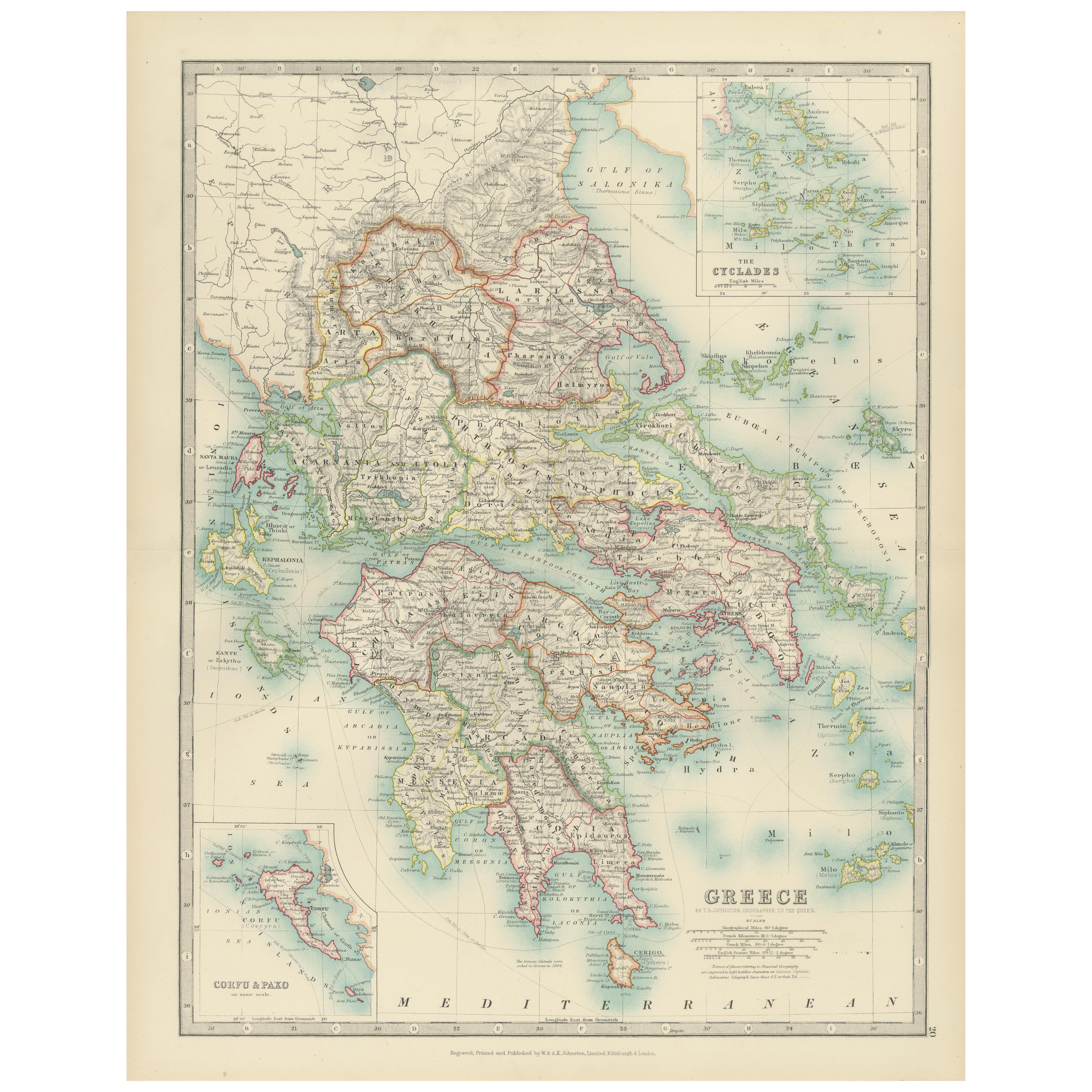
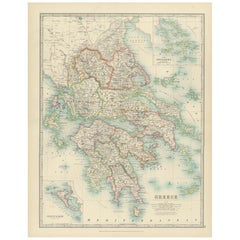
Antique Map of Greece and the Cyclades, 1903, with Many Details and Inset Maps
Title: Antique Map of Greece and the Cyclades, 1903, with Intricate Detail and Inset Maps
Description: This antique map, titled "Greece with Its Islands, Including the Cyclades," wa...
Categoria
Inizio XX secolo, Mappe
Materiali
Carta
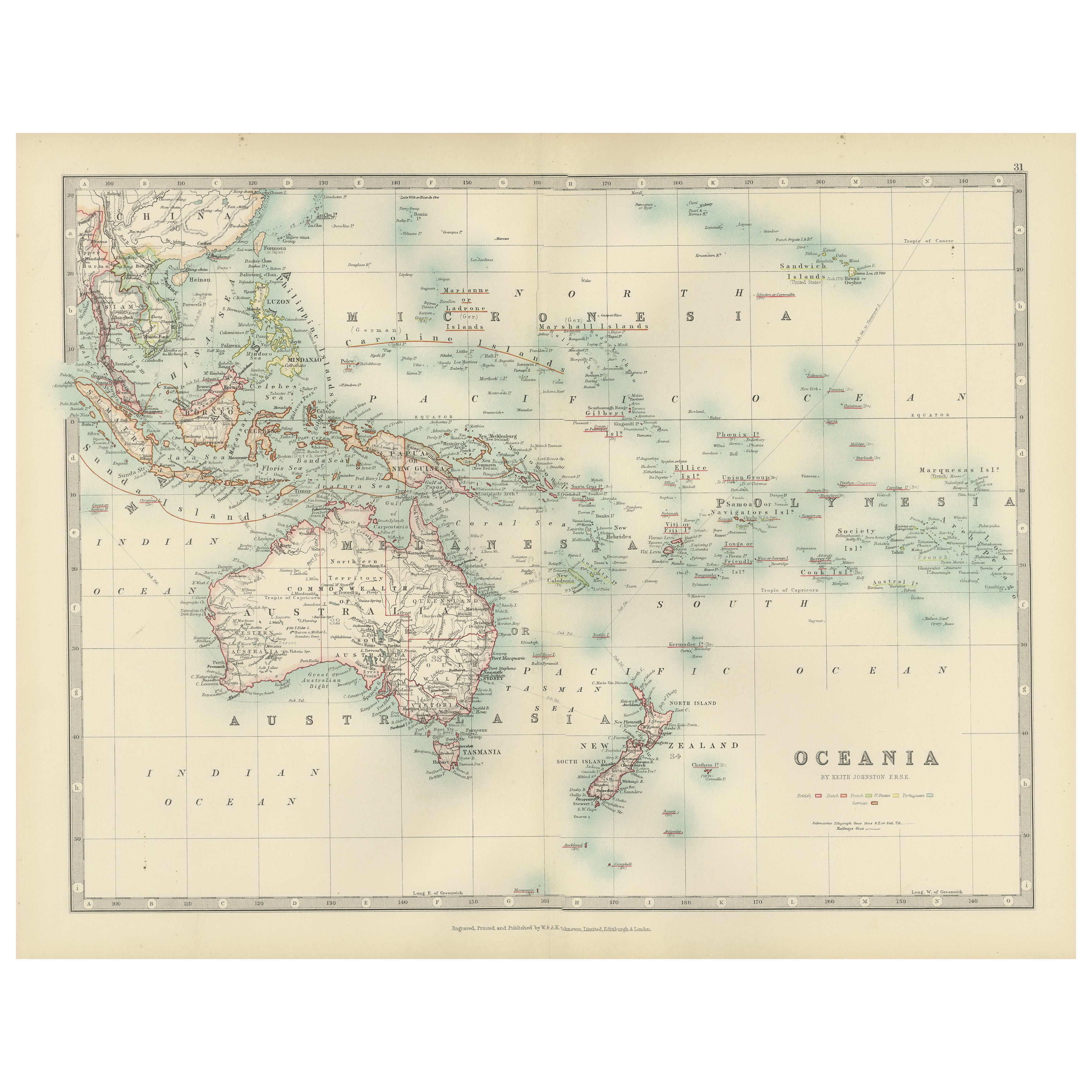
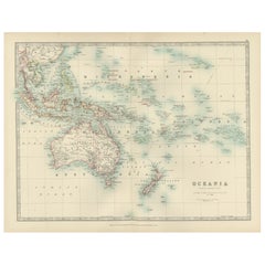
Antique Map of Oceania, 1903, Featuring the Pacific Islands and Australasia
Title: Antique Map of Oceania, 1903, Featuring the Pacific Islands and Australasian Region
Description:
This antique map, titled "Oceania," was engraved and published in 1903 by W. ...
Categoria
Inizio XX secolo, Mappe
Materiali
Carta
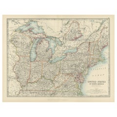
Antique Map of the Northeast USA - Vibrant 1903 Cartographic Detail
Map of the Northeastern United States of North America, 1903
This striking antique map titled “United States of North America (North Eastern Sheet)” was created by the renowned Scot...
Categoria
Inizio XX secolo, Mappe
Materiali
Carta
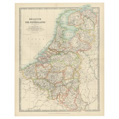
Antique Map of Belgium and The Netherlands with Delicate Pastel Coloration, 1903
Antique Map of Belgium and The Netherlands, 1903, with Delicate Pastel Coloration
This antique map, titled "Belgium and The Netherlands," was engraved and published in 1903 by the d...
Categoria
Inizio XX secolo, Mappe
Materiali
Carta
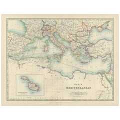
Antique Map of the Mediterranean Basin, 1903, with Detailed Coastal and Inland
Title: Antique Map of the Mediterranean Basin, 1903, with Detailed Coastal and Inland Geography
Description: This antique map, titled "Basin of the Mediterranean," was engraved and ...
Categoria
Inizio XX secolo, Mappe
Materiali
Carta
Ti potrebbe interessare anche
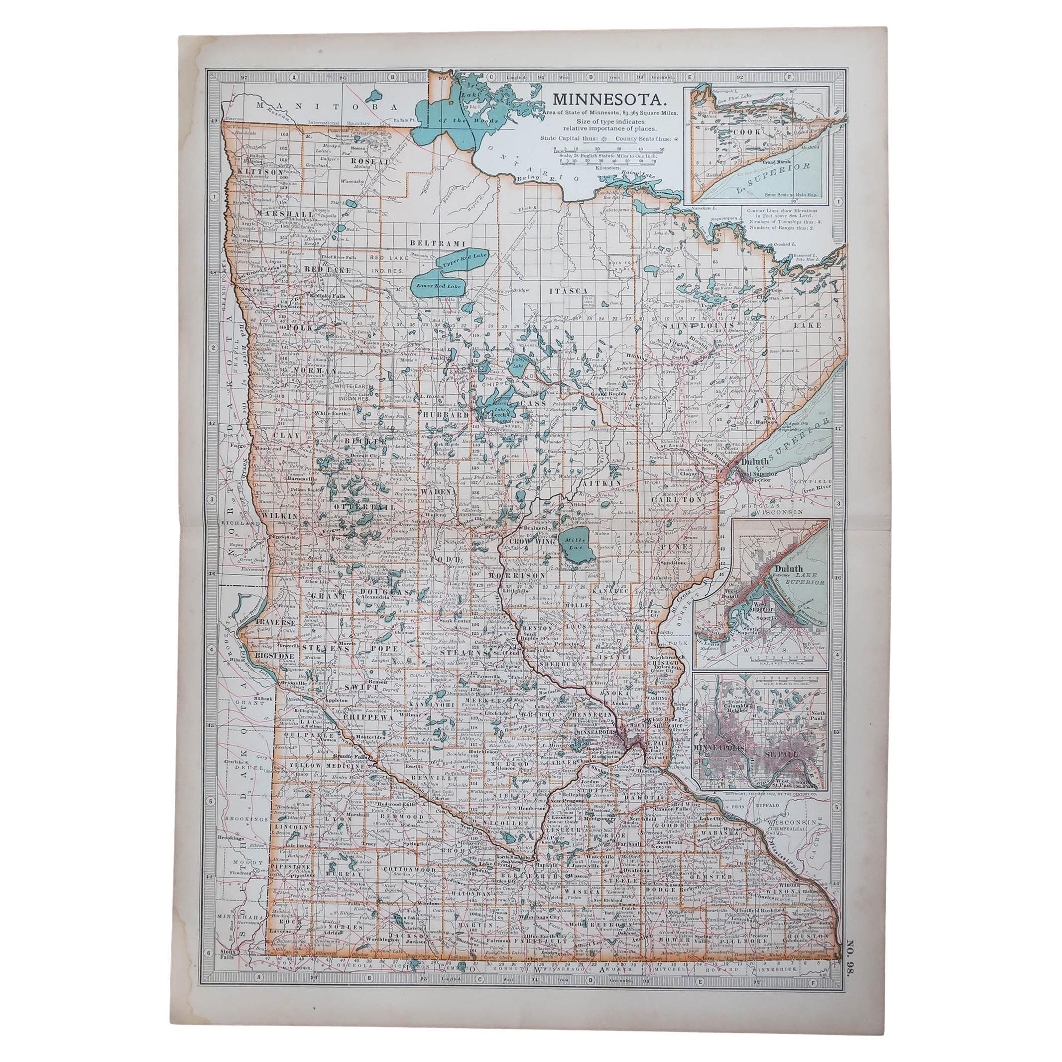
Mappa antica originale dello Stato americano del Minnesota, 1903
Mappa antica del Minnesota
Pubblicato da A.I.C. Black. 1903
Colore originale
Buono stato
Senza cornice.
Spedizione gratuita
Categoria
Di antiquariato/d’epoca, Inizio Novecento, Inglese, Mappe
Materiali
Carta

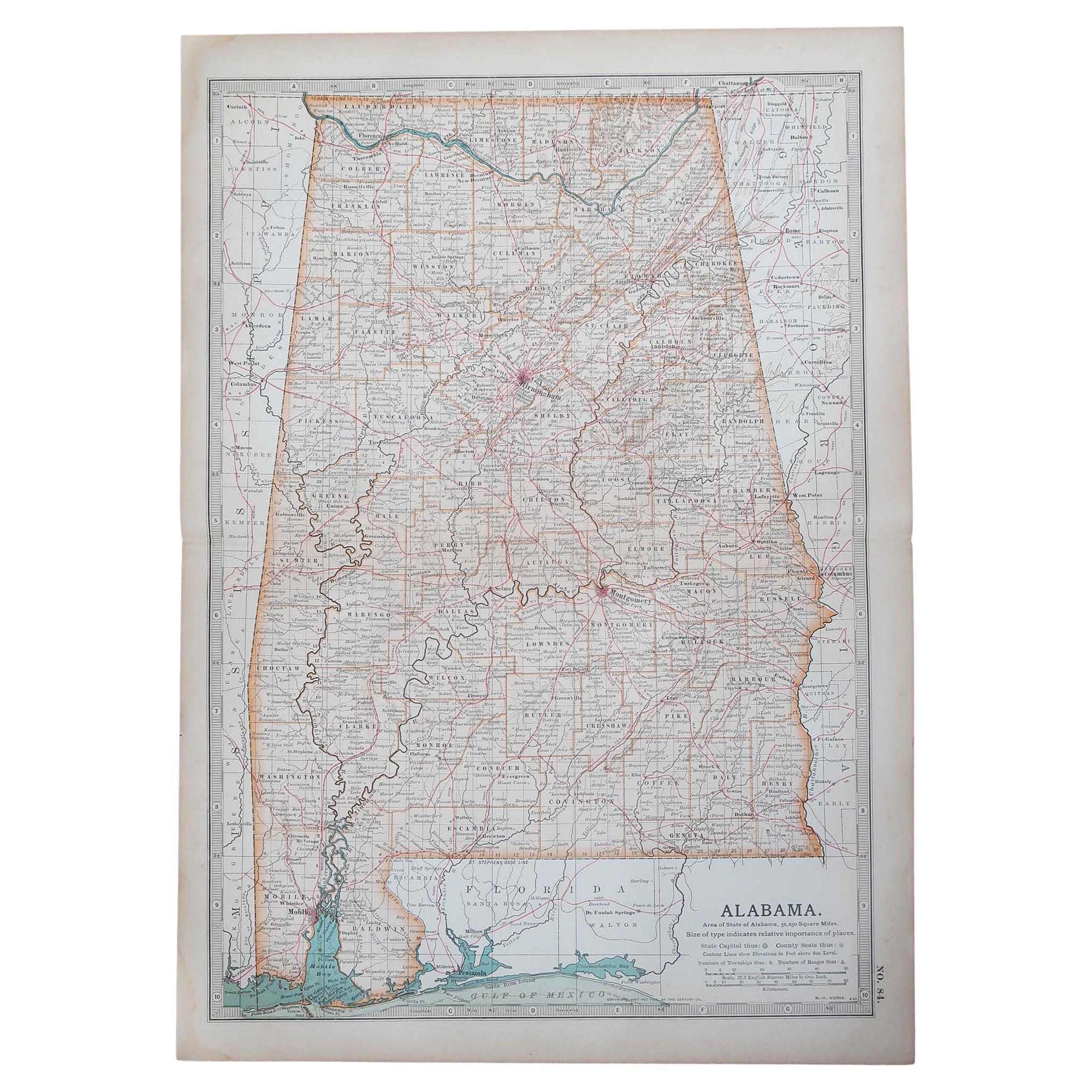
Mappa antica originale dello Stato americano dell'Alabama, 1903
Antique map of Alabama
Published By A & C Black. 1903
Original colour
Good condition
Unframed.
Free shipping
Categoria
Di antiquariato/d’epoca, Inizio Novecento, Inglese, Mappe
Materiali
Carta

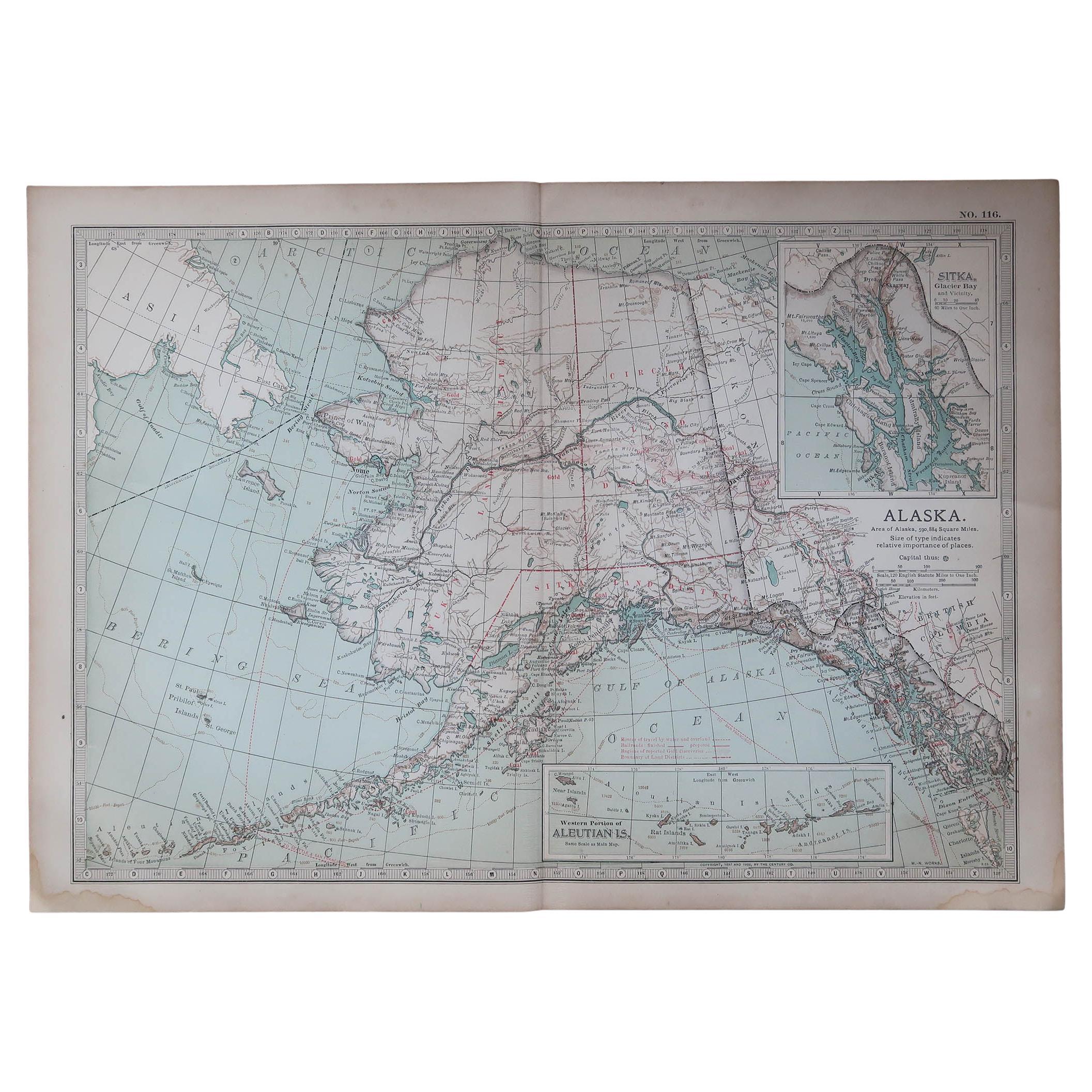
Mappa antica originale dello Stato americano dell'Alaska, 1903
Mappa antica dell'Alaska
Pubblicato da A.I.C. Black. 1903
Colore originale
Buono stato
Senza cornice.
Spedizione gratuita
Categoria
Di antiquariato/d’epoca, Inizio Novecento, Inglese, Mappe
Materiali
Carta

Mappa antica originale dello Stato americano del Nebraska, 1903
Mappa antica del Nebraska
Pubblicato da A.I.C. Black. 1903
Colore originale
Buono stato
Senza cornice.
Spedizione gratuita
Categoria
Di antiquariato/d’epoca, Inizio Novecento, Inglese, Mappe
Materiali
Carta

Mappa antica originale dello Stato americano di Washington, 1903
Mappa antica di Washington
Pubblicato da A.I.C. Black. 1903
Colore originale
Buono stato
Senza cornice.
Spedizione gratuita
Categoria
Di antiquariato/d’epoca, Inizio Novecento, Inglese, Mappe
Materiali
Carta

Mappa antica originale dello Stato americano del Tennessee, 1903
Antique map of Tennessee
Published By A & C Black. 1903
Original colour
Good condition
Unframed.
Free shipping
Categoria
Di antiquariato/d’epoca, Inizio Novecento, Inglese, Mappe
Materiali
Carta
