Articoli simili a Map of Basses-Alpes France with Digne and Lavender Region by Vuillemin, c.1850


Vuoi altre immagini o video?
Richiedi altre immagini o video al venditore
1 di 10
Map of Basses-Alpes France with Digne and Lavender Region by Vuillemin, c.1850
120 €IVA inclusa
Informazioni sull’articolo
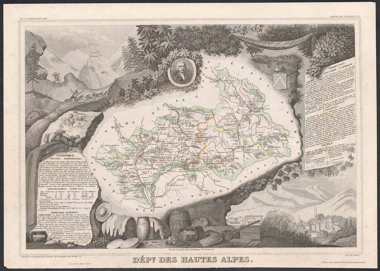
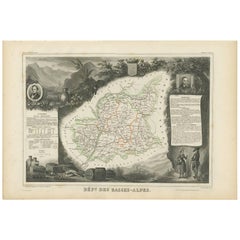
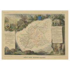
Map of Basses-Alpes France with Digne and Lavender Region by Vuillemin, 19th c
This finely engraved 19th-century map of the Basses-Alpes department of France (known today as Alpes-de-Haute-Provence) is from the renowned Nouvel Atlas Illustré by Alexandre Vuillemin, published by Migeon in Paris. It features delicate hand coloring, regional detail, and elegant vignettes that highlight the cultural and natural identity of the area.
The map outlines the department of Basses-Alpes with clear detail, showcasing towns, rivers, and roads, bordered in soft pastel colors. The mountains, passes, and valleys are rendered with precision, reflecting the department's alpine geography. In the upper left corner, a vignette depicts the town of Digne (now Digne-les-Bains), the administrative center of the department, with the Alps rising in the distance. The bottom left corner features a mountain goat resting on the rocks—an allusion to the region’s wildlife and rugged landscape. To the right, a portrait of Jean-Baptiste Gassendi, philosopher, astronomer, and native of the region, brings historical depth to the composition. Birds flying along the right edge further emphasize the natural richness of the region.
Basses-Alpes is particularly renowned for its stunning lavender fields, which blanket the landscape in purple during summer months. This region, especially the areas around Digne, Forcalquier, and Valensole, is one of the key sources of French lavender, used in perfumes, soaps, and essential oils. In addition to lavender, the region also produces honey, olives, and wines from the Vin de Pays des Alpes-de-Haute-Provence designation.
Alexandre Vuillemin, the cartographer, was a noted 19th-century French mapmaker whose decorative atlases combined geography with culture and art. His publisher, Migeon, specialized in beautifully illustrated educational works. Together, they produced maps that were both informative and visually compelling, popular among scholars and collectors alike.
Condition summary:
Very good condition with slight toning to the margins and a few faint foxing spots, mostly in outer areas. The engraved details are sharp and the original hand-coloring remains clean and attractive.
Framing tips:
This map pairs beautifully with a medium or dark wood frame, or an antique gold moulding to highlight the historic charm. A soft cream or light lavender-toned mat can complement the regional theme. UV-protective glass is recommended to ensure long-term preservation.
- Dimensioni:Altezza: 26,1 cm (10,28 in)Larghezza: 32,5 cm (12,8 in)Profondità: 0,2 mm (0,01 in)
- Materiali e tecniche:Carta,Inciso
- Luogo di origine:
- Periodo:
- Data di produzione:circa 1850
- Condizioni:Very good condition with slight toning to the margins and a few faint foxing spots, mostly in outer areas. The engraved details are sharp and the original hand-coloring remains clean and attractive.
- Località del venditore:Langweer, NL
- Numero di riferimento:Venditore: BG-13331-41stDibs: LU3054345359142
Informazioni sul venditore
5,0
Venditore riconosciuto
Questi venditori prestigiosi sono leader del settore e rappresentano il massimo in termini di qualità e design.
Venditore Platino
Venditori Premium con valutazione 4.7+ e tempi di risposta entro 24 ore
Fondazione nel 2009
Venditore 1stDibs dal 2017
2609 vendite su 1stDibs
Tempo di risposta standard: <1 ora
- SpedizioneRecupero del preventivo…Spedizione da: Langweer, Paesi Bassi
- Politica di reso
Alcune parti di questa pagina sono state tradotte automaticamente. 1stDibs non può garantire che le traduzioni siano corrette. L’inglese è la lingua predefinita del sito.
Garanzia di autenticità
Nell’improbabile caso in cui si verifichi un problema con l’autenticità di un articolo, contattaci entro un anno per ottenere un rimborso completo. DettagliGaranzia di rimborso
Se il tuo articolo non corrisponde alla descrizione, è danneggiato durante il trasporto o non arriva, contattaci entro 7 giorni per un rimborso completo. DettagliAnnullamento entro 24 ore
Hai un periodo di tolleranza di 24 ore per annullare il tuo acquisto, senza necessità di fornire spiegazioni.Venditori professionali selezionati
I nostri venditori di livello internazionale devono aderire a rigorosi standard di servizio e qualità, garantendo l’integrità delle inserzioni.Garanzia miglior prezzo
Se scopri che un venditore ha pubblicato altrove lo stesso articolo a un prezzo più basso, applicheremo lo stesso prezzo.Consegna globale affidabile
La nostra rete di vettori leader del settore offre opzioni di spedizione specializzate in tutto il mondo, inclusa la consegna personalizzata.Altro da questo venditore
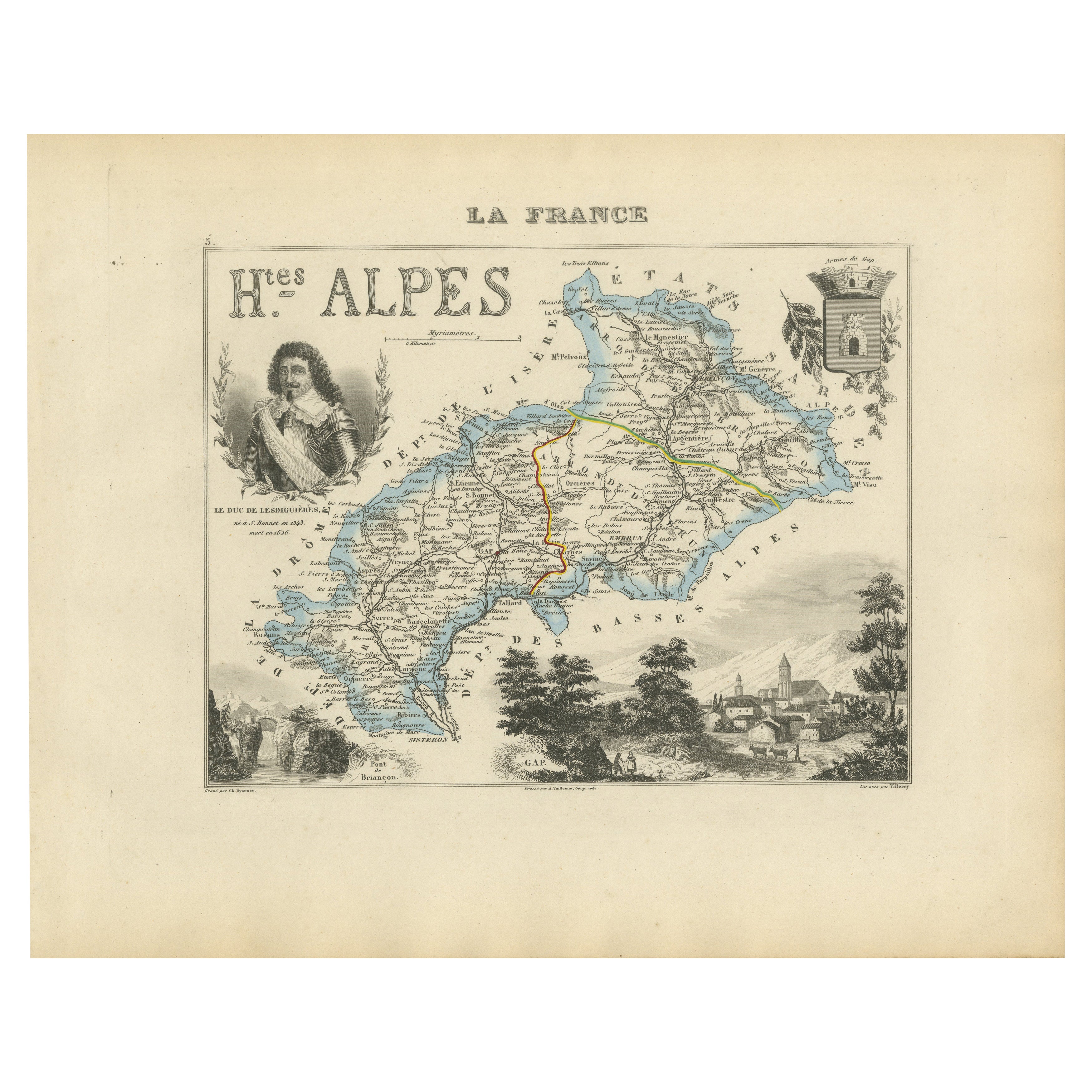
Mostra tuttoMap of Hautes-Alpes France with Gap and Alpine Scenery by Vuillemin, c.1850
Map of Hautes-Alpes France with Gap and Alpine Scenery by Vuillemin
Description:
This elegant 19th-century map of the Hautes-Alpes department in southeastern France was created by A...
Categoria
Di antiquariato/d’epoca, Metà XIX secolo, Francese, Mappe
Materiali
Carta

Map of Ain France with Vineyards of Bugey and Notable Portraits, c.1850
Map of Ain France with Portraits of Bichat and Joubert by Vuillemin, 19th c
This highly decorative 19th-century map of the French department of Ain is taken from the celebrated Nouv...
Categoria
Di antiquariato/d’epoca, Metà XIX secolo, Francese, Mappe
Materiali
Carta

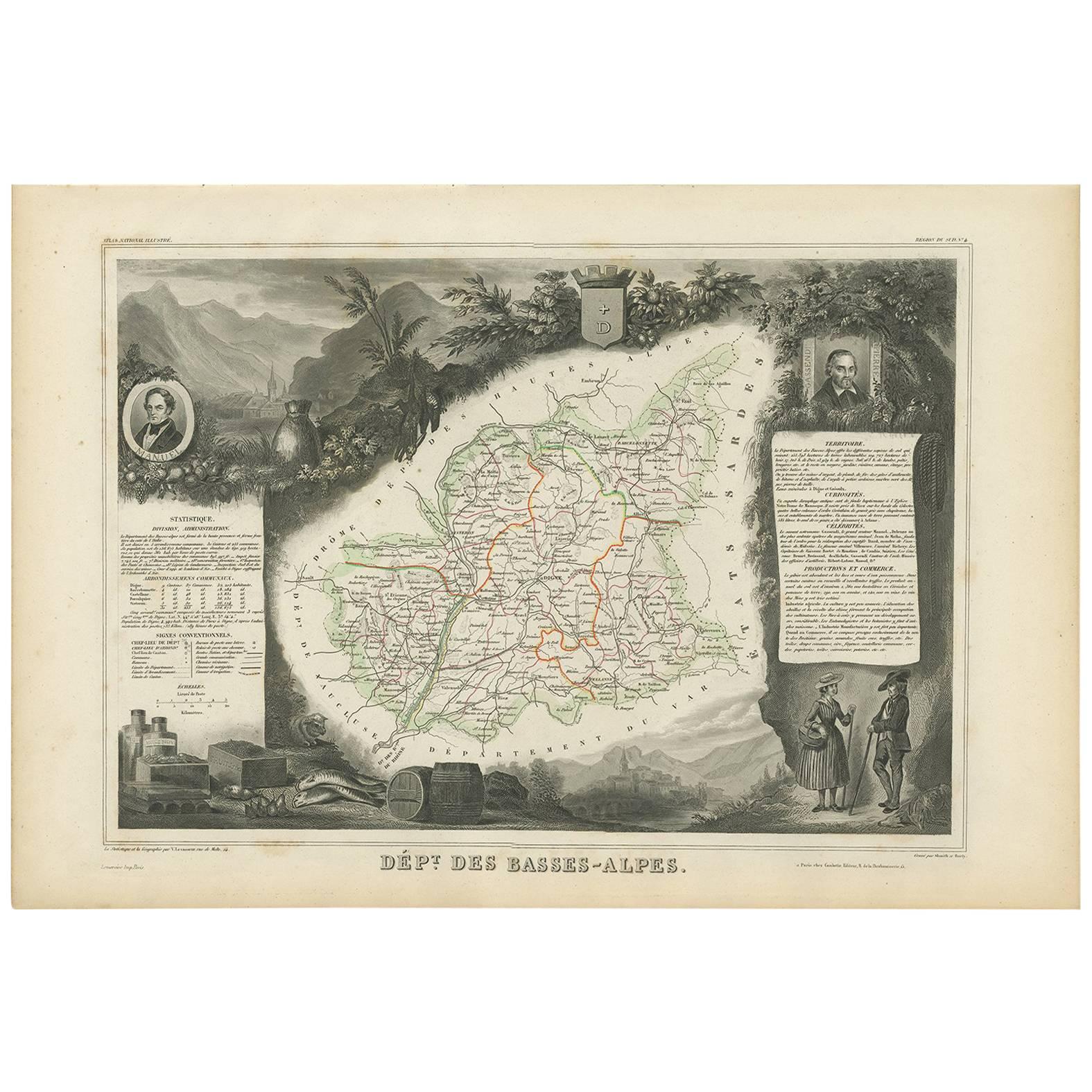
Carta geografica antica di Basses-Alpes 'Francia' di V. Levasseur, 1854
Di Victor Levasseur
Carta geografica antica intitolata "Dépt. des Basses-Alpes". Mappa del dipartimento francese delle Basses-Alpes, Francia. Il tutto è circondato da elaborate incisioni decorative pens...
Categoria
Di antiquariato/d’epoca, Metà XIX secolo, Mappe
Materiali
Carta
160 € Prezzo promozionale
20% in meno
Map of Allier France with Saint-Pourçain Wine Region by Vuillemin, 19th c
Map of Allier France with Saint-Pourçain Wine Region by Vuillemin, 19th c
This decorative 19th-century map of Allier, a central department of France, comes from the celebrated Nouve...
Categoria
Di antiquariato/d’epoca, Metà XIX secolo, Francese, Mappe
Materiali
Carta

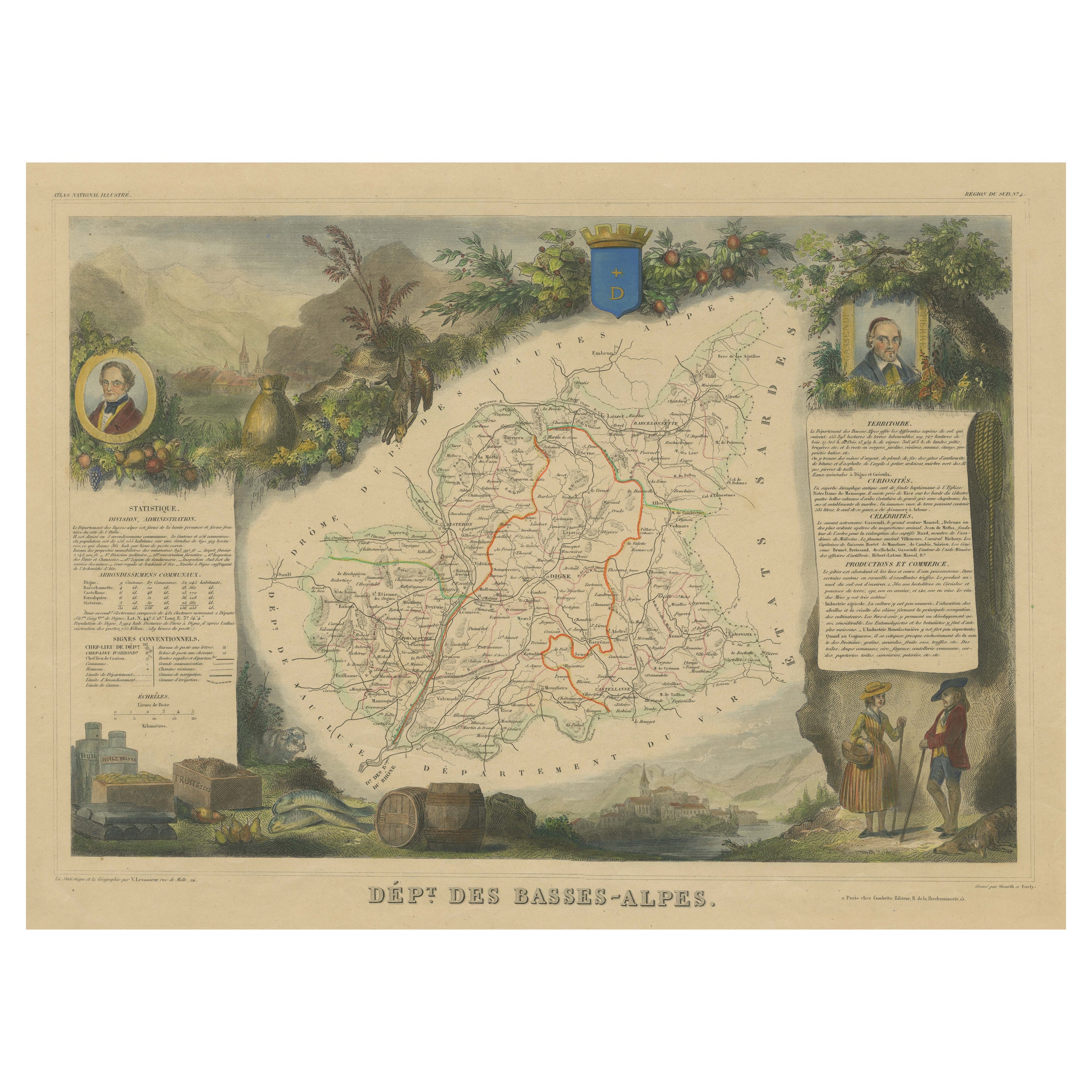
Mappa antica colorata a mano del Dipartimento delle Basses-Alpes, Francia
Di Victor Levasseur
Carta geografica antica intitolata "Dépt. de l'Aube". Mappa del dipartimento francese delle Basses-Alpes, Francia. Il tutto è circondato da elaborate incisioni decorative pensate per...
Categoria
Di antiquariato/d’epoca, Metà XIX secolo, Mappe
Materiali
Carta
272 € Prezzo promozionale
20% in meno
Map of Côtes-du-Nord France with Saint-Brieuc and Brittany Coastline, c.1850
Map of Côtes-du-Nord France with Saint-Brieuc and Brittany Coastline, 19th c
Description:
This elegant 19th-century map of Côtes-du-Nord, the historic name for what is now known as ...
Categoria
Di antiquariato/d’epoca, Metà XIX secolo, Francese, Mappe
Materiali
Carta

Ti potrebbe interessare anche
Hautes Alpes, Francia. Mappa antica di un dipartimento francese, 1856
Di Victor Levasseur
Dept. des Hautes Alpes", incisione in acciaio con colorazione a mano dei contorni originali, 1856, da "Atlas National Illustre" di Levasseur.
Questa zona della Francia è nota per l...
Categoria
XIX secolo, Naturalismo, Stampe (paesaggio)
Materiali
Incisione

Alti Pirenei, Francia. Mappa antica di un dipartimento francese, 1856
Di Victor Levasseur
'Dept. des Hautes Pyrenees', incisione in acciaio con colorazione a mano dei contorni originali, 1856, dall'Atlas National Illustre di Levasseur.
In quest'area si trova la regione ...
Categoria
XIX secolo, Naturalismo, Stampe (paesaggio)
Materiali
Incisione
Pirenei Orientali, Francia. Mappa antica di un dipartimento francese, 1856
Di Victor Levasseur
'Dept. des Pyrenees Orientales', incisione in acciaio con colorazione a mano dei contorni originali, 1856, da 'Atlas National Illustre' di Levasseur.
Quest'area è una nota regione ...
Categoria
XIX secolo, Naturalismo, Stampe (paesaggio)
Materiali
Incisione

Mappa degli Hautes-Pyrénées - Litografia originale - XIX secolo
La Mappa degli Hautes-Pyrénées è una litografia originale realizzata da un incisore anonimo del XIX secolo.
Stampato in serie "France Pittoresque" in alto al centro.
Lo stato di co...
Categoria
XIX secolo, Moderno, Stampe figurative
Materiali
Carta, Litografia

Bella mappa antica del 1856, acquerellata a mano, del Dipartimento delle Hautes Alpes di Levasseur
Siamo lieti di offrire in vendita questa splendida mappa ad acquerello del 1856 delle Alpi austriache, intitolata Dept Des Hautes Alpes, tratta dall'Atlas National Illustre y Victor ...
Categoria
Di antiquariato/d’epoca, Anni 1850, Francese, Primo vittoriano, Mappe
Materiali
Carta

617 € Prezzo promozionale
30% in meno
Lozere, Francia. Mappa antica di un dipartimento francese, 1856
Di Victor Levasseur
'Dept. de La Lozere', incisione in acciaio con colorazione a mano dei contorni originali, 1856, da 'Atlas National Illustre' di Levasseur.
Questa remota zona montuosa della Linguad...
Categoria
XIX secolo, Naturalismo, Stampe (paesaggio)
Materiali
Incisione
