Articoli simili a Map of Brittany and Western France by Gerard Valk, circa 1690


Vuoi altre immagini o video?
Richiedi altre immagini o video al venditore
1 di 10
Map of Brittany and Western France by Gerard Valk, circa 1690
770 €IVA inclusa
Informazioni sull’articolo
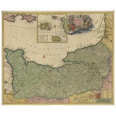
Map of Brittany and Western France by Gerard Valk, circa 1700
This finely detailed antique map, titled *Praefectura Ducatus Britanniae, Quae Superior et Inferior*, was created around 1700 by the Dutch cartographer Gerard Valk. It presents an expansive view of the Duchy of Brittany (Bretagne), historically one of the most culturally distinct and politically significant regions of France. The map reaches eastward to include major cities such as Nantes, Rennes, and Saint-Malo, showing the full extent of both Upper and Lower Brittany.
Gerard Valk (1652–1726) was a prominent mapmaker and globe manufacturer based in Amsterdam. He collaborated with Pieter Schenk and other leading Dutch engravers to publish a number of influential atlases and wall maps. Valk’s maps are known for their clarity, strong engraving technique, and elegant color schemes, and they remain highly desirable among collectors of early cartography.
This particular map displays the western peninsula of France in striking detail, with its rugged coastlines along the Atlantic Ocean, islands such as Belle-Île, and extensive inland geography. Administrative divisions are outlined in yellow and pink hand-coloring, clearly marking the boundaries of ecclesiastical and civil jurisdictions. Towns, rivers, forests, and roadways are all carefully engraved, creating a layered and accurate representation of the region as it stood at the dawn of the 18th century.
The map includes references to bishoprics and archbishoprics, underlining the strong ecclesiastical structure of the region. Its Latin title and classical labeling reflect the scholarly nature of maps in this period, serving both practical and educational purposes.
As a historical object, this map captures a time just before the unification and modernization of the French administrative system. Brittany still retained elements of its medieval autonomy and cultural identity, especially through its language, customs, and religious institutions.
Condition summary:
Good condition with original hand-coloring. Centerfold as issued. Slight toning at edges, but overall crisp and well-preserved. Strong paper.
Framing tips:
Best suited for a gold or dark wood frame with a warm off-white or ivory mat. This will enhance the classical feel and draw out the color contrast. Use museum glass to preserve the detail and reduce glare.
- Dimensioni:Altezza: 51,7 cm (20,36 in)Larghezza: 60,5 cm (23,82 in)Profondità: 0,2 mm (0,01 in)
- Materiali e tecniche:Carta,Inciso
- Luogo di origine:
- Periodo:Fine XVII secolo
- Data di produzione:circa 1690
- Condizioni:Good condition with original hand-coloring. Centerfold as issued. Slight toning at edges, but overall crisp and well-preserved. Strong paper.
- Località del venditore:Langweer, NL
- Numero di riferimento:Venditore: BG-13732-61stDibs: LU3054345364142
Informazioni sul venditore
5,0
Venditore riconosciuto
Questi venditori prestigiosi sono leader del settore e rappresentano il massimo in termini di qualità e design.
Venditore Platino
Venditori Premium con valutazione 4.7+ e tempi di risposta entro 24 ore
Fondazione nel 2009
Venditore 1stDibs dal 2017
2626 vendite su 1stDibs
Tempo di risposta standard: <1 ora
- SpedizioneRecupero del preventivo…Spedizione da: Langweer, Paesi Bassi
- Politica di reso
Alcune parti di questa pagina sono state tradotte automaticamente. 1stDibs non può garantire che le traduzioni siano corrette. L’inglese è la lingua predefinita del sito.
Garanzia di autenticità
Nell’improbabile caso in cui si verifichi un problema con l’autenticità di un articolo, contattaci entro un anno per ottenere un rimborso completo. DettagliGaranzia di rimborso
Se il tuo articolo non corrisponde alla descrizione, è danneggiato durante il trasporto o non arriva, contattaci entro 7 giorni per un rimborso completo. DettagliAnnullamento entro 24 ore
Hai un periodo di tolleranza di 24 ore per annullare il tuo acquisto, senza necessità di fornire spiegazioni.Venditori professionali selezionati
I nostri venditori di livello internazionale devono aderire a rigorosi standard di servizio e qualità, garantendo l’integrità delle inserzioni.Garanzia miglior prezzo
Se scopri che un venditore ha pubblicato altrove lo stesso articolo a un prezzo più basso, applicheremo lo stesso prezzo.Consegna globale affidabile
La nostra rete di vettori leader del settore offre opzioni di spedizione specializzate in tutto il mondo, inclusa la consegna personalizzata.Altro da questo venditore
Mostra tuttoRara mappa colorata a mano della Lorena e del Barrois, Francia di Frederik De Wit del 1688 ca.
Titolo: Rara mappa colorata a mano della Lorrain e del Barrois di Frederik De Wit, 1688 ca.
Descrizione: Questa notevole mappa del XVII secolo, intitolata "Generalis Lotharingiae Du...
Categoria
Di antiquariato/d’epoca, Anni 1680, Mappe
Materiali
Carta

Bellissima mappa del XVII secolo di Parigi e dell'Isola di Francia di Templeux, 1650 ca.
Mappa dell'Isola di Francia di D. A. de Templeux, 1650 circa, colorata a mano e decorativa
Questa mappa antica ricca di dettagli intitolata *Le Gouvernement de L'Isle de France* è s...
Categoria
Di antiquariato/d’epoca, Anni 1650, Mappe
Materiali
Carta

Mappa originale della Normandia di Frederick de Wit, 1705, con inserto delle Isole del Canale
Mappa della Normandia di Frederick de Wit, 1705, con inserto delle Isole del Canale
Descrizione:
Questa splendida mappa incisa e colorata a mano, intitolata Duché et Gouvernement Ge...
Categoria
Di antiquariato/d’epoca, Inizio Settecento, Mappe
Materiali
Carta
Carta geografica antica della Francia di Tirion, 1740 ca.
Carta geografica antica intitolata "Nieuwe Kaart van Frankryk". - Attraente mappa dettagliata che mostra la Francia. Titolo in cartiglio a blocchi con una semplice rosa dei venti. Fo...
Categoria
Di antiquariato/d’epoca, XVIII secolo, Mappe
Materiali
Carta
360 € Prezzo promozionale
20% in meno
Splendida mappa colorata a mano della Linguadoca in Francia di Frederik De Wit del 1688 ca.
Titolo: Splendida mappa colorata a mano della Linguadoca di Frederik De Wit del 1688 circa
Descrizione: Questa elegante mappa del XVII secolo, "Gouvernement General de Languedoc", i...
Categoria
Di antiquariato/d’epoca, Anni 1680, Mappe
Materiali
Carta
Carta geografica antica della Francia di Mortier '1730 ca.
Mappa antica intitolata "Galliae Antiquae Tabula". Mappa antica originale della Francia nell'antichità. Pubblicato da P. Mortier, circa 1730.
Categoria
Di antiquariato/d’epoca, Metà XVIII secolo, Mappe
Materiali
Carta

900 € Prezzo promozionale
25% in meno
Ti potrebbe interessare anche
1640 Carta di Joan Bleau intitolata "Diocecese de rheims et le pais de rethel, " Eic.a011
1640 Mappa di Joan Bleau intitolata
"Diocecese di Reims e il paese di Rethel".
Ric.a011
OAN BLAEU
Diocecese di Reims e il paese di Rethel.
Incisione colorata a mano, 1...
Categoria
Di antiquariato/d’epoca, XVII secolo, Olandese, Mappe
Materiali
Carta

1752 Carta delle Fiandre di Vaugoundy: Belgio, Francia e Paesi Bassi, Ric.a002
Grande mappa delle Fiandre di Vaugoundy:
Belgio, Francia e Paesi Bassi
Colorato -1752
Ric.a002
Descrizione: Questa è una mappa delle Fiandre di Didier Robert de Vaugondy del ...
Categoria
Di antiquariato/d’epoca, XVII secolo, Sconosciuto, Mappe
Materiali
Carta

La regione francese della Normandia: Una mappa colorata a mano del XVII secolo di Sanson e Jaillot
Di Nicholas Sanson d'Abbeville
Questa grande mappa colorata a mano intitolata "Le Duché et Gouvernement de Normandie divisée en Haute et Basse Normandie en divers Pays; et par evêchez, avec le Gouvernement General...
Categoria
Anni 1690, Stampe (paesaggio)
Materiali
Incisione

Carta di Bonne del 1771 del Poitou, della Touraine e dell'Anjou, Francia, Ric.a015
1771 Bonne Map of Poitou,
Touraine e Anjou, Francia
Ric.a015
1771 Carta geografica di Potiou, della Touraine e dell'Anjou intitolata "Carte des Gouvernements D'Anjou et du S...
Categoria
Di antiquariato/d’epoca, XVII secolo, Sconosciuto, Mappe
Materiali
Carta

1635 Willem Blaeu Mappa della Francia settentrionale "Comitatvs Bellovacvm" Ric.a08
Mappa del 1635 di Willem Blaeu della Francia settentrionale, intitolata.
"Comitatvs Bellovacvm Vernacule Beavvais".
Colorato
Ric.a008
"COMITATVS BELLOVACVM..." Amsterdam: Wil...
Categoria
Di antiquariato/d’epoca, XVII secolo, Sconosciuto, Mappe
Materiali
Carta

La Valle della Loira in Francia: Una mappa colorata a mano del XVII secolo di Sanson e Jaillot
Di Nicholas Sanson d'Abbeville
Questa grande mappa incisa a mano su lastra di rame del XVII secolo intitolata "Gouvernement D'Orleans et la Generalite divisee en ses Elections Par le Sanson" è stata originariament...
Categoria
Anni 1690, Stampe (paesaggio)
Materiali
Incisione
