Articoli simili a Map of Calvados France with Caen and Cider-Brandy Region, 19th Century


Vuoi altre immagini o video?
Richiedi altre immagini o video al venditore
1 di 10
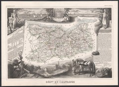
Map of Calvados France with Caen and Cider-Brandy Region, 19th Century
120 €IVA inclusa
Informazioni sull’articolo
Map of Calvados France with Caen and Cider-Brandy Region, 19th Century
Description:
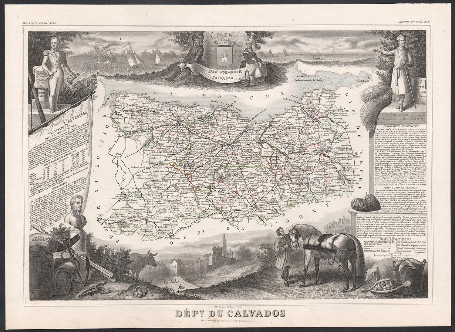
This finely engraved 19th-century map of the Calvados department in Normandy, northwestern France, comes from the *Nouvel Atlas Illustré* published in Paris by Migeon. The map was drawn by Alexandre Vuillemin and features a rich combination of precise geography and elegant embellishments, reflecting the historical and agricultural importance of this coastal region.
The map outlines Calvados in soft pink hand-coloring, highlighting towns, rivers, and roads, with the English Channel (La Manche) bordering the north. Caen, the department's capital and a cultural center since medieval times, is prominently positioned. The cartographic detailing includes the famed Norman countryside and coast, which played a vital role in French history and later in World War II.
In the lower left is a portrait of Dumont d’Urville, the explorer and naval officer born in Condé-sur-Noireau in Calvados. He is shown with nautical instruments, referencing his significant contributions to French exploration and science. In the lower right is a finely rendered view of the city of Caen, with its imposing Gothic architecture, likely representing the Church of Saint-Pierre or the Abbey of Saint-Étienne founded by William the Conqueror.
Calvados is perhaps best known for its namesake apple brandy, produced in the rolling orchards that stretch across the region. The department lies at the heart of the Calvados AOC, where cider apples are grown and distilled into one of France’s most iconic spirits. Alongside Calvados brandy, the region also produces fine cider, pommeau, and a range of cheeses, most notably Pont-l'Évêque and Livarot. These agricultural products have earned Calvados a reputation for rustic elegance and culinary depth.
This map captures the spirit of Normandy's maritime heritage, its agricultural landscape, and its intellectual legacy, making it ideal for collectors of historic French regions or food and wine enthusiasts.
Condition summary:
Very good condition with some light toning and minor foxing to the margins. The engraved detail is crisp, and the original hand coloring is well preserved.
Framing tips:
A rustic oak or walnut frame would match the map’s Norman character. A soft ivory or light grey mat will highlight the pink border color and the engraved vignette of Caen. Use museum-quality glass to protect and enhance the print for display.
- Dimensioni:Altezza: 26,1 cm (10,28 in)Larghezza: 32,5 cm (12,8 in)Profondità: 0,2 mm (0,01 in)
- Materiali e tecniche:Carta,Inciso
- Luogo di origine:
- Periodo:
- Data di produzione:circa 1850
- Condizioni:Very good condition with some light toning and minor foxing to the margins. The engraved detail is crisp, and the original hand coloring is well preserved.
- Località del venditore:Langweer, NL
- Numero di riferimento:Venditore: BG-13331-131stDibs: LU3054345359802
Informazioni sul venditore
5,0
Venditore riconosciuto
Questi venditori prestigiosi sono leader del settore e rappresentano il massimo in termini di qualità e design.
Venditore Platino
Venditori Premium con valutazione 4.7+ e tempi di risposta entro 24 ore
Fondazione nel 2009
Venditore 1stDibs dal 2017
2607 vendite su 1stDibs
Tempo di risposta standard: <1 ora
- SpedizioneRecupero del preventivo…Spedizione da: Langweer, Paesi Bassi
- Politica di reso
Alcune parti di questa pagina sono state tradotte automaticamente. 1stDibs non può garantire che le traduzioni siano corrette. L’inglese è la lingua predefinita del sito.
Garanzia di autenticità
Nell’improbabile caso in cui si verifichi un problema con l’autenticità di un articolo, contattaci entro un anno per ottenere un rimborso completo. DettagliGaranzia di rimborso
Se il tuo articolo non corrisponde alla descrizione, è danneggiato durante il trasporto o non arriva, contattaci entro 7 giorni per un rimborso completo. DettagliAnnullamento entro 24 ore
Hai un periodo di tolleranza di 24 ore per annullare il tuo acquisto, senza necessità di fornire spiegazioni.Venditori professionali selezionati
I nostri venditori di livello internazionale devono aderire a rigorosi standard di servizio e qualità, garantendo l’integrità delle inserzioni.Garanzia miglior prezzo
Se scopri che un venditore ha pubblicato altrove lo stesso articolo a un prezzo più basso, applicheremo lo stesso prezzo.Consegna globale affidabile
La nostra rete di vettori leader del settore offre opzioni di spedizione specializzate in tutto il mondo, inclusa la consegna personalizzata.Altro da questo venditore
Mostra tuttoMap of Allier France with Saint-Pourçain Wine Region by Vuillemin, 19th c
Map of Allier France with Saint-Pourçain Wine Region by Vuillemin, 19th c
This decorative 19th-century map of Allier, a central department of France, comes from the celebrated Nouve...
Categoria
Di antiquariato/d’epoca, Metà XIX secolo, Francese, Mappe
Materiali
Carta

Map of Côtes-du-Nord France with Saint-Brieuc and Brittany Coastline, c.1850
Map of Côtes-du-Nord France with Saint-Brieuc and Brittany Coastline, 19th c
Description:
This elegant 19th-century map of Côtes-du-Nord, the historic name for what is now known as ...
Categoria
Di antiquariato/d’epoca, Metà XIX secolo, Francese, Mappe
Materiali
Carta

Map of Côte-d'Or France with Dijon and Burgundy Wine Region, 19th Century
Map of Côte-d'Or France with Dijon and Burgundy Wine Region, 19th Century
Description:
This beautifully engraved 19th-century map of Côte-d'Or, located in the historic region of Bur...
Categoria
Di antiquariato/d’epoca, Metà XIX secolo, Francese, Mappe
Materiali
Carta

Carta geografica antica di Calvados 'Francia' di V. Levasseur, 1854
Di Victor Levasseur
Carta geografica antica intitolata "Dépt. du Calvados". Mappa del dipartimento francese del Calvados, Francia. Questa zona della Francia è nota per la produzione del Calvados, il bra...
Categoria
Di antiquariato/d’epoca, Metà XIX secolo, Mappe
Materiali
Carta
160 € Prezzo promozionale
20% in meno
Map of Aude France with Carcassonne and Languedoc Vineyards, 19th Century
Map of Aude France with Carcassonne and Languedoc Vineyards, 19th Century
Description:
This elegant 19th-century map of Aude, a department in southern France along the Mediterranean...
Categoria
Di antiquariato/d’epoca, Metà XIX secolo, Francese, Mappe
Materiali
Carta

Carta geografica antica di Calais 'Francia' di V. Levasseur, 1854
Di Victor Levasseur
Carta geografica antica intitolata "Dépt. du Pas de Calais". Mappa del dipartimento francese di Calais, Francia. Questa zona è nota per la produzione del Maroilles, un formaggio a pa...
Categoria
Di antiquariato/d’epoca, Metà XIX secolo, Mappe
Materiali
Carta
144 € Prezzo promozionale
20% in meno
Ti potrebbe interessare anche
Calvados, Francia. Mappa antica di un dipartimento francese, 1856
Di Victor Levasseur
'Dept. du Calvados', incisione in acciaio con colorazione a mano dei contorni originali, 1856, da 'Atlas National Illustre' di Levasseur.
Questa zona della Francia è nota per la pr...
Categoria
XIX secolo, Naturalismo, Stampe (paesaggio)
Materiali
Incisione
Grande mappa della Francia del XIX secolo
Grande mappa della Francia del XIX secolo.
Condizioni notevoli, con una piacevole patina di usura.
Incorniciato di recente.
Francia, circa 1874.
Categoria
Di antiquariato/d’epoca, Fine XIX secolo, Francese, Mappe
Materiali
Lino, Carta

Circa 1950 original map poster of Calvados, designed by André Lesot - Normandy
Questa mappa originale del Calvados del 1950 circa, disegnata da André Lesot, è una rappresentazione splendidamente dettagliata di questa storica regione della Normandia, in Francia....
Categoria
Anni 1950, Stampe e riproduzioni
Materiali
Litografia, Carta, Lino
Aude, Francia. Mappa antica di un dipartimento francese, 1856
Di Victor Levasseur
'Dept. de L' Aude', incisione in acciaio con colorazione a mano dei contorni originali, 1856, da 'Atlas National Illustre' di Levasseur.
Questa zona della Francia è famosa per l'am...
Categoria
XIX secolo, Naturalismo, Stampe (paesaggio)
Materiali
Incisione

Var, Francia. Mappa antica di un dipartimento francese, 1856
Di Victor Levasseur
Dept. du Var", incisione in acciaio con colorazione a mano dei contorni originali, 1856, dall'Atlas National Illustre di Levasseur.
Il Var copre il cuore della Costa Azzurra e comp...
Categoria
XIX secolo, Naturalismo, Stampe (paesaggio)
Materiali
Incisione

Francia, Part One. Mappa antica Century Atlas
L'Atlante del Secolo. Francia, parte settentrionale".
Mappa antica originale, 1903.
Cartine di "Francia in Province" e "Parigi e dintorni".
Piega centrale come da edizione. Nome e ...
Categoria
Inizio XX secolo, Vittoriano, Altre stampe
Materiali
Litografia
