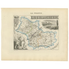
Articoli simili a Map of Cher France with Bourges, Sancerre Vineyards and Engraved Vignettes, 1850


Vuoi altre immagini o video?
Richiedi altre immagini o video al venditore
1 di 10
Map of Cher France with Bourges, Sancerre Vineyards and Engraved Vignettes, 1850
120 €IVA inclusa
Informazioni sull’articolo
Map of Charente-Inférieure France with La Rochelle and Coastal Vineyards, 19th c
Description:
This decorative 19th-century map of the former department of Charente-Inférieure, now known as Charente-Maritime, was published in Paris by Migeon as part of the *Nouvel Atlas Illustré* and drawn by Alexandre Vuillemin. The map combines precise geographic rendering with visual storytelling, capturing the essence of France’s Atlantic coast during the mid-1800s.
Hand-colored in soft pink along the departmental borders, the map includes all major towns and transport routes, with La Rochelle and Rochefort prominently featured. The Atlantic coastline, river systems, and offshore islands such as Île de Ré and Île d’Oléron are clearly indicated. These elements emphasize the maritime identity of the region, historically shaped by naval, commercial, and fishing activity.
In the lower portion of the sheet is an engraved view of the fortified port city of La Rochelle, its harbor marked by towers and stone quays. At the top right, dockworkers are shown with a large anchor and chains, illustrating Rochefort’s role as an important naval base and shipyard during the Ancien Régime and Napoleonic era. On the right side is a portrait of de Ratzau, likely referring to the marquis who played a role in 17th-century military affairs in the region.
Charente-Maritime is also known for its viticulture, particularly its contribution to the Cognac region. Vineyards near Saintes and Jonzac form part of the outer areas of Cognac production. Additionally, the region is famous for its Pineau des Charentes, a sweet fortified wine blending grape must and Cognac. These coastal vineyards thrive in a maritime climate, producing grapes with distinctive character.
Beyond wine, the region is also celebrated for salt marshes, oysters from Marennes-Oléron, and a strong seafaring heritage. This map is an elegant tribute to a historically rich region whose legacy blends land, sea, and cultural depth.
Condition summary:
Very good antique condition. Light age toning and minor scattered foxing, mostly near the margins. Engraved lines are clear and the original hand coloring is well preserved.
Framing tips:
Pair this map with a light wood or brushed silver frame to echo the maritime setting. Use a pale blue or cream mat to complement the coastal theme and pastel borders. UV-protective glass is recommended for display and preservation.
- Dimensioni:Altezza: 32,5 cm (12,8 in)Larghezza: 26,1 cm (10,28 in)Profondità: 0,2 mm (0,01 in)
- Materiali e tecniche:Carta,Inciso
- Luogo di origine:
- Periodo:
- Data di produzione:circa 1850
- Condizioni:Very good antique condition. Light age toning and minor scattered foxing, mostly near the margins. Engraved lines are clear and the original hand coloring is well preserved.
- Località del venditore:Langweer, NL
- Numero di riferimento:Venditore: BG-13331-171stDibs: LU3054345363582
Informazioni sul venditore
5,0
Venditore riconosciuto
Questi venditori prestigiosi sono leader del settore e rappresentano il massimo in termini di qualità e design.
Venditore Platino
Venditori Premium con valutazione 4.7+ e tempi di risposta entro 24 ore
Fondazione nel 2009
Venditore 1stDibs dal 2017
2666 vendite su 1stDibs
Tempo di risposta standard: <1 ora
- SpedizioneRecupero del preventivo…Spedizione da: Langweer, Paesi Bassi
- Politica di reso
Alcune parti di questa pagina sono state tradotte automaticamente. 1stDibs non può garantire che le traduzioni siano corrette. L’inglese è la lingua predefinita del sito.
Garanzia di autenticità
Nell’improbabile caso in cui si verifichi un problema con l’autenticità di un articolo, contattaci entro un anno per ottenere un rimborso completo. DettagliGaranzia di rimborso
Se il tuo articolo non corrisponde alla descrizione, è danneggiato durante il trasporto o non arriva, contattaci entro 7 giorni per un rimborso completo. DettagliAnnullamento entro 24 ore
Hai un periodo di tolleranza di 24 ore per annullare il tuo acquisto, senza necessità di fornire spiegazioni.Venditori professionali selezionati
I nostri venditori di livello internazionale devono aderire a rigorosi standard di servizio e qualità, garantendo l’integrità delle inserzioni.Garanzia miglior prezzo
Se scopri che un venditore ha pubblicato altrove lo stesso articolo a un prezzo più basso, applicheremo lo stesso prezzo.Consegna globale affidabile
La nostra rete di vettori leader del settore offre opzioni di spedizione specializzate in tutto il mondo, inclusa la consegna personalizzata.Altro da questo venditore
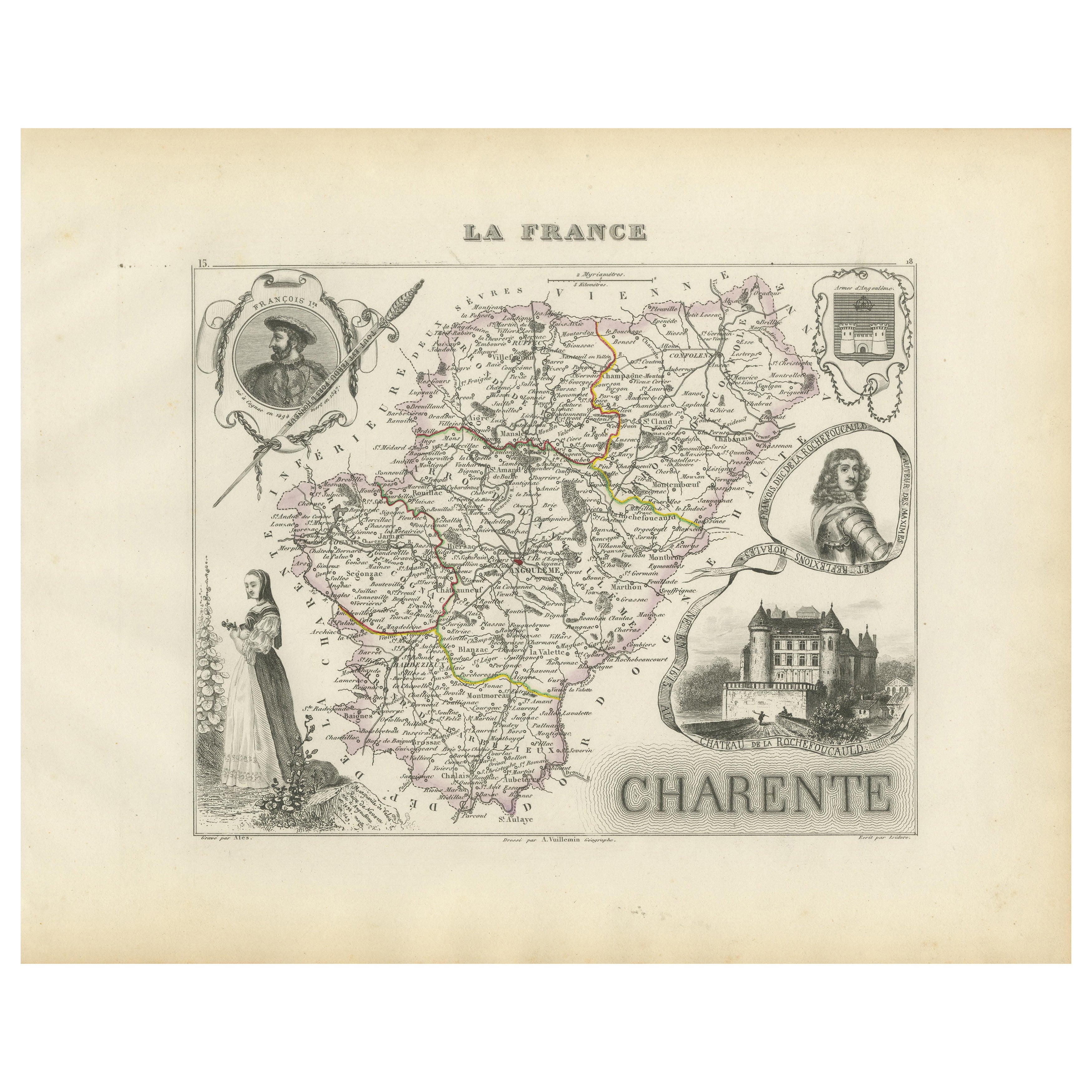
Mostra tuttoMap of Charente France with Cognac Region and Château de La Rochefoucauld, 1850
Map of Charente France with Cognac Region and Château de La Rochefoucauld, 19th c
Description:
This richly illustrated 19th-century map of the Charente department in southwestern Fr...
Categoria
Di antiquariato/d’epoca, Metà XIX secolo, Francese, Mappe
Materiali
Carta

Mappa di Gers Francia con Auch e la regione vinicola dell'Armagnac di Vuillemin, XIX sec.
Mappa di Gers Francia con Auch e la regione vinicola dell'Armagnac di Vuillemin, XIX sec.
Questa mappa incisa e colorata a mano del XIX secolo del dipartimento di Gers, nel sud-oves...
Categoria
Di antiquariato/d’epoca, Metà XIX secolo, Francese, Mappe
Materiali
Carta

Map of Côtes-du-Nord France with Saint-Brieuc and Brittany Coastline, c.1850
Map of Côtes-du-Nord France with Saint-Brieuc and Brittany Coastline, 19th c
Description:
This elegant 19th-century map of Côtes-du-Nord, the historic name for what is now known as ...
Categoria
Di antiquariato/d’epoca, Metà XIX secolo, Francese, Mappe
Materiali
Carta

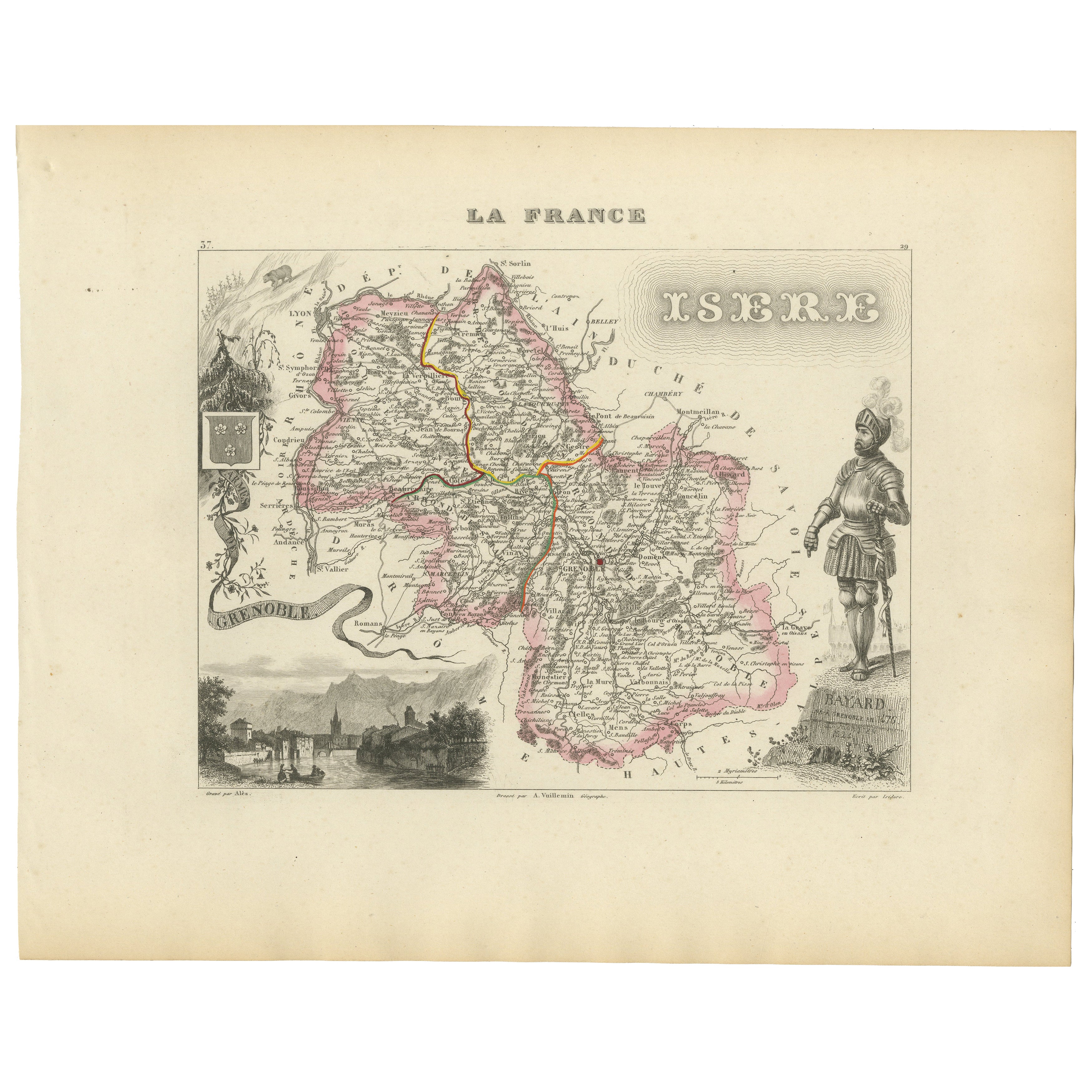
Antique French Map of Isère Region with Grenoble, Vienne, Dauphiné, 1800s
Carta geografica antica dell'Isère, Francia di Vuillemin, XIX secolo
Questa mappa decorativa del XIX secolo presenta il dipartimento dell'Isère nel sud-est della Francia, incisa da ...
Categoria
Di antiquariato/d’epoca, Metà XIX secolo, Francese, Mappe
Materiali
Carta
Map of Allier France with Saint-Pourçain Wine Region by Vuillemin, 19th c
Map of Allier France with Saint-Pourçain Wine Region by Vuillemin, 19th c
This decorative 19th-century map of Allier, a central department of France, comes from the celebrated Nouve...
Categoria
Di antiquariato/d’epoca, Metà XIX secolo, Francese, Mappe
Materiali
Carta

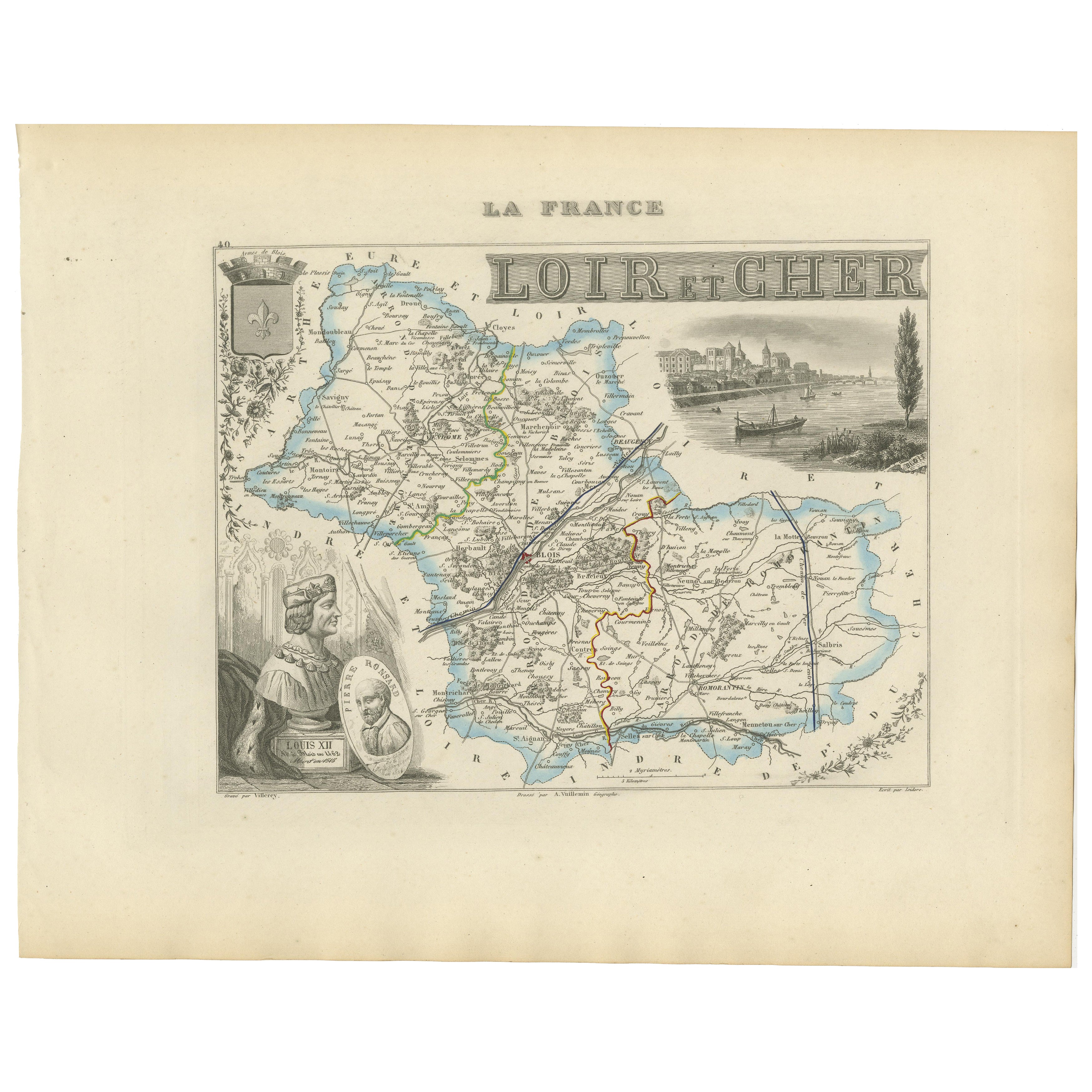
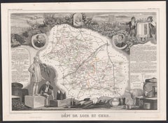
Mappa del XIX secolo di Loir-et-Cher, Francia - Blois, Vendôme, Castelli della Valle della Loira
Carta geografica antica di Loir-et-Cher, Francia di Vuillemin, XIX secolo
Una splendida mappa incisa del XIX secolo del dipartimento di Loir-et-Cher, disegnata e incisa da Alexandre...
Categoria
Di antiquariato/d’epoca, Metà XIX secolo, Francese, Mappe
Materiali
Carta
Ti potrebbe interessare anche
Loir e Cher, Francia. Mappa antica di un dipartimento francese, 1856
Di Victor Levasseur
'Dept. de Loir e Cher', incisione in acciaio con colorazione a mano dei contorni originali, 1856, dall'Atlas National Illustre di Levasseur.
Questa zona è conosciuta soprattutto pe...
Categoria
XIX secolo, Naturalismo, Stampe (paesaggio)
Materiali
Incisione
Aube, Francia. Mappa antica di un dipartimento francese, 1856
Di Victor Levasseur
'Dept. de L'Aube', incisione in acciaio con colorazione a mano dei contorni originali, 1856, da 'Atlas National Illustre' di Levasseur.
Questa zona della Francia è nota per la prod...
Categoria
XIX secolo, Naturalismo, Stampe (paesaggio)
Materiali
Incisione

L'Isere, Francia. Mappa antica del dipartimento francese, 1856
Di Victor Levasseur
'Dept. de L'Isere', incisione in acciaio con colorazione a mano dei contorni originali, 1856, da 'Atlas National Illustre' di Levasseur.
Questa zona è nota per la produzione del Bl...
Categoria
XIX secolo, Naturalismo, Stampe (paesaggio)
Materiali
Incisione

Indre e Loira, Francia. Mappa antica di un dipartimento francese, 1856
Di Victor Levasseur
'Dept. d'Indre et Loire', incisione in acciaio con colorazione a mano dei contorni originali, 1856, da 'Atlas National Illustre' di Levasseur.
Questa zona è nota per la produzione ...
Categoria
XIX secolo, Naturalismo, Stampe (paesaggio)
Materiali
Incisione

Lozere, Francia. Mappa antica di un dipartimento francese, 1856
Di Victor Levasseur
'Dept. de La Lozere', incisione in acciaio con colorazione a mano dei contorni originali, 1856, da 'Atlas National Illustre' di Levasseur.
Questa remota zona montuosa della Linguad...
Categoria
XIX secolo, Naturalismo, Stampe (paesaggio)
Materiali
Incisione

Aude, Francia. Mappa antica di un dipartimento francese, 1856
Di Victor Levasseur
'Dept. de L' Aude', incisione in acciaio con colorazione a mano dei contorni originali, 1856, da 'Atlas National Illustre' di Levasseur.
Questa zona della Francia è famosa per l'am...
Categoria
XIX secolo, Naturalismo, Stampe (paesaggio)
Materiali
Incisione
