Articoli simili a Map of Gard France with Pont du Gard and Wine Regions by Vuillemin, 19th c


Vuoi altre immagini o video?
Richiedi altre immagini o video al venditore
1 di 10
Map of Gard France with Pont du Gard and Wine Regions by Vuillemin, 19th c
140 €IVA inclusa
Informazioni sull’articolo
Title: Map of Gard France with Pont du Gard and Wine Regions by Vuillemin, 19th c
Description:
This finely engraved 19th-century map of the department of Gard in southern France was produced by Alexandre Vuillemin and published by Migeon in Paris as part of the *Nouvel Atlas Illustré*. The map blends detailed topographical information with artistic embellishments, offering a window into the geography, culture, and heritage of the region.
Gard is located in the Occitanie region and borders the Mediterranean Sea, Ardèche, Hérault, Bouches-du-Rhône, and Lozère. The map outlines the department with a fine hand-colored orange border and clearly marks towns, rivers, roadways, and topographic features. Nîmes, Uzès, Alès, and Beaucaire are among the many towns shown in detail.
At the lower left, a beautifully rendered vignette features the iconic **Pont du Gard**, a Roman aqueduct that stands as one of the most impressive and well-preserved Roman engineering feats in France. Built in the first century AD, it carried water to the city of Nîmes and remains a UNESCO World Heritage Site.
To the lower right, the map includes a portrait of **Jacques-Joseph de Gourbillon**, a local historical figure, with an unfurled map scroll and inscription. A coat of arms and botanical ornamentation add further decorative elements to the sheet.
Gard is also well known for its wine production, forming part of the greater **Côtes du Rhône** appellation. Vineyards near the Rhône River, including those around Tavel and Lirac, are especially notable. Tavel produces one of France’s most celebrated rosé wines, known for its full body, dry character, and historical reputation—it was said to be a favorite of Louis XIV and Ernest Hemingway. The department also produces reds and whites under the Costières de Nîmes and Duché d’Uzès AOCs, showcasing a blend of Mediterranean climate and Rhône varietals such as Syrah, Grenache, Mourvèdre, and Viognier.
Alexandre Vuillemin, a highly regarded French cartographer of the 19th century, was known for his clear yet decorative maps. His works with Migeon often included informative and picturesque features that made geography accessible and engaging to a broader audience.
Condition summary:
Very good condition with light age toning at the edges and a few minor foxing marks. The engraved detail remains sharp and the hand coloring is clean and well-preserved.
Framing tips:
Frame this map in a natural walnut or classic gold frame to enhance the historic charm. A warm ivory or pale terracotta mat will complement the orange border and Mediterranean tone of the subject. UV-protective glass is recommended for conservation.
- Dimensioni:Altezza: 26,1 cm (10,28 in)Larghezza: 32,5 cm (12,8 in)Profondità: 0,2 mm (0,01 in)
- Materiali e tecniche:Carta,Inciso
- Luogo di origine:
- Periodo:
- Data di produzione:circa 1850
- Condizioni:Very good condition with light age toning at the edges and a few minor foxing marks. The engraved detail remains sharp and the hand coloring is clean and well-preserved.
- Località del venditore:Langweer, NL
- Numero di riferimento:Venditore: BG-13331-291stDibs: LU3054345363922
Informazioni sul venditore
5,0
Venditore riconosciuto
Questi venditori prestigiosi sono leader del settore e rappresentano il massimo in termini di qualità e design.
Venditore Platino
Venditori Premium con valutazione 4.7+ e tempi di risposta entro 24 ore
Fondazione nel 2009
Venditore 1stDibs dal 2017
2662 vendite su 1stDibs
Tempo di risposta standard: <1 ora
- SpedizioneRecupero del preventivo…Spedizione da: Langweer, Paesi Bassi
- Politica di reso
Alcune parti di questa pagina sono state tradotte automaticamente. 1stDibs non può garantire che le traduzioni siano corrette. L’inglese è la lingua predefinita del sito.
Garanzia di autenticità
Nell’improbabile caso in cui si verifichi un problema con l’autenticità di un articolo, contattaci entro un anno per ottenere un rimborso completo. DettagliGaranzia di rimborso
Se il tuo articolo non corrisponde alla descrizione, è danneggiato durante il trasporto o non arriva, contattaci entro 7 giorni per un rimborso completo. DettagliAnnullamento entro 24 ore
Hai un periodo di tolleranza di 24 ore per annullare il tuo acquisto, senza necessità di fornire spiegazioni.Venditori professionali selezionati
I nostri venditori di livello internazionale devono aderire a rigorosi standard di servizio e qualità, garantendo l’integrità delle inserzioni.Garanzia miglior prezzo
Se scopri che un venditore ha pubblicato altrove lo stesso articolo a un prezzo più basso, applicheremo lo stesso prezzo.Consegna globale affidabile
La nostra rete di vettori leader del settore offre opzioni di spedizione specializzate in tutto il mondo, inclusa la consegna personalizzata.Altro da questo venditore
Mostra tuttoMap of Allier France with Saint-Pourçain Wine Region by Vuillemin, 19th c
Map of Allier France with Saint-Pourçain Wine Region by Vuillemin, 19th c
This decorative 19th-century map of Allier, a central department of France, comes from the celebrated Nouve...
Categoria
Di antiquariato/d’epoca, Metà XIX secolo, Francese, Mappe
Materiali
Carta

Mappa di Gers Francia con Auch e la regione vinicola dell'Armagnac di Vuillemin, XIX sec.
Mappa di Gers Francia con Auch e la regione vinicola dell'Armagnac di Vuillemin, XIX sec.
Questa mappa incisa e colorata a mano del XIX secolo del dipartimento di Gers, nel sud-oves...
Categoria
Di antiquariato/d’epoca, Metà XIX secolo, Francese, Mappe
Materiali
Carta

Map of Côtes-du-Nord France with Saint-Brieuc and Brittany Coastline, c.1850
Map of Côtes-du-Nord France with Saint-Brieuc and Brittany Coastline, 19th c
Description:
This elegant 19th-century map of Côtes-du-Nord, the historic name for what is now known as ...
Categoria
Di antiquariato/d’epoca, Metà XIX secolo, Francese, Mappe
Materiali
Carta

Map of Ain France with Vineyards of Bugey and Notable Portraits, c.1850
Map of Ain France with Portraits of Bichat and Joubert by Vuillemin, 19th c
This highly decorative 19th-century map of the French department of Ain is taken from the celebrated Nouv...
Categoria
Di antiquariato/d’epoca, Metà XIX secolo, Francese, Mappe
Materiali
Carta

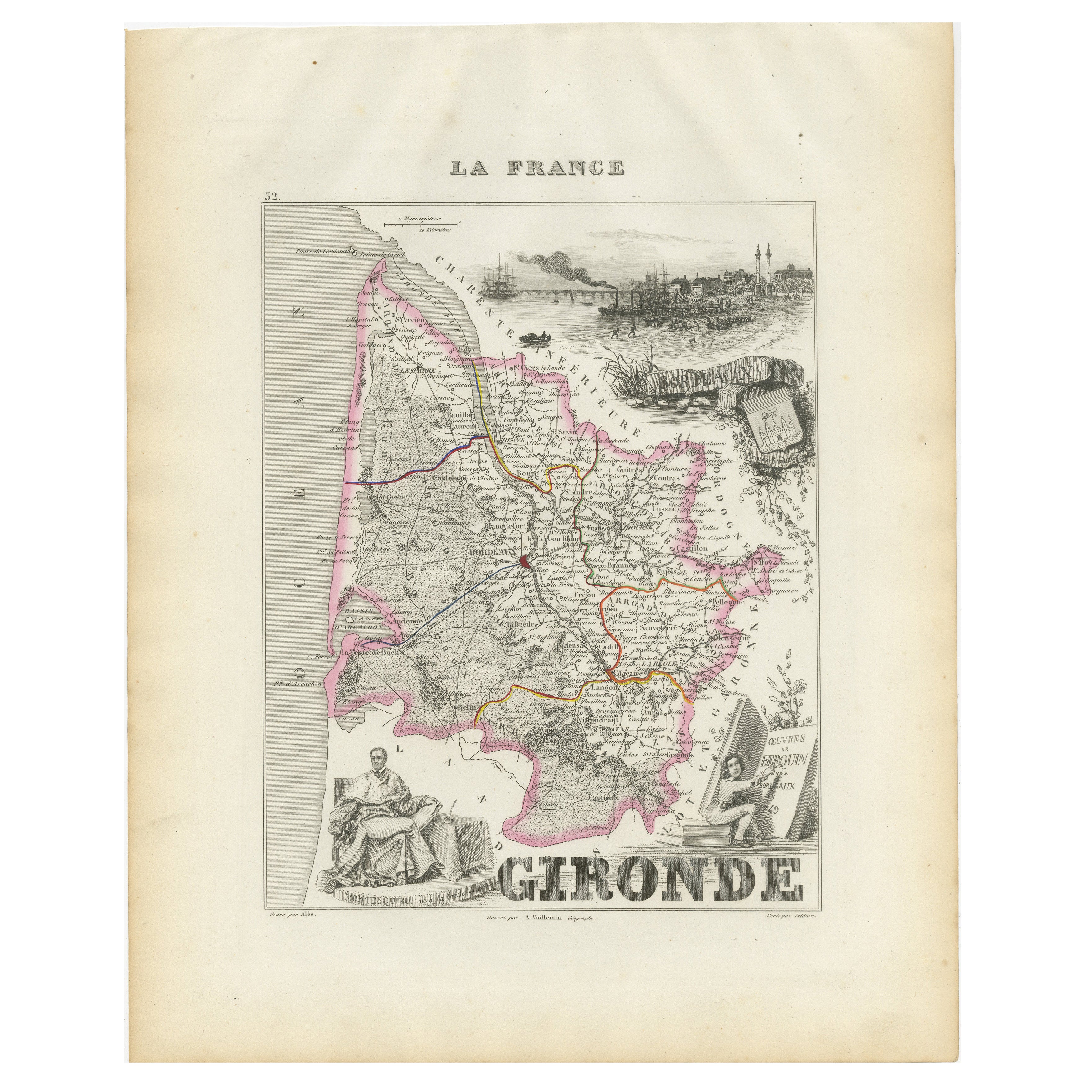
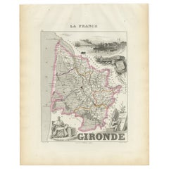
Mappa della Gironda in Francia con la regione vinicola di Bordeaux di Vuillemin, XIX sec.
Mappa della Gironda in Francia con la regione vinicola di Bordeaux di Vuillemin, XIX sec.
Questa splendida mappa del XIX secolo della Gironda, in Francia, fa parte del Nouvel Atlas ...
Categoria
Di antiquariato/d’epoca, Metà XIX secolo, Francese, Mappe
Materiali
Carta
Map of Aisne France with Soissons and Champagne Vineyards by Vuillemin, 19th c
Map of Aisne France with Soissons and Champagne Vineyards by Vuillemin, 19th c
Description:
This richly detailed 19th-century engraved and hand-colored map of the department of Aisn...
Categoria
Di antiquariato/d’epoca, Metà XIX secolo, Francese, Mappe
Materiali
Carta

Ti potrebbe interessare anche
Grande mappa della Francia del XIX secolo
Grande mappa della Francia del XIX secolo.
Condizioni notevoli, con una piacevole patina di usura.
Incorniciato di recente.
Francia, circa 1874.
Categoria
Di antiquariato/d’epoca, Fine XIX secolo, Francese, Mappe
Materiali
Lino, Carta

Var, Francia. Mappa antica di un dipartimento francese, 1856
Di Victor Levasseur
Dept. du Var", incisione in acciaio con colorazione a mano dei contorni originali, 1856, dall'Atlas National Illustre di Levasseur.
Il Var copre il cuore della Costa Azzurra e comp...
Categoria
XIX secolo, Naturalismo, Stampe (paesaggio)
Materiali
Incisione

Saone e Loira, Francia. Mappa antica di un dipartimento francese, 1856
Di Victor Levasseur
'Dept. de Saone et Loire', incisione in acciaio con colorazione a mano dei contorni originali, 1856, dall'Atlas National Illustre di Levasseur.
Il dipartimento francese di Saone et...
Categoria
XIX secolo, Naturalismo, Stampe (paesaggio)
Materiali
Incisione

Aude, Francia. Mappa antica di un dipartimento francese, 1856
Di Victor Levasseur
'Dept. de L' Aude', incisione in acciaio con colorazione a mano dei contorni originali, 1856, da 'Atlas National Illustre' di Levasseur.
Questa zona della Francia è famosa per l'am...
Categoria
XIX secolo, Naturalismo, Stampe (paesaggio)
Materiali
Incisione

Francia, Part One. Mappa antica Century Atlas
L'Atlante del Secolo. Francia, parte settentrionale".
Mappa antica originale, 1903.
Cartine di "Francia in Province" e "Parigi e dintorni".
Piega centrale come da edizione. Nome e ...
Categoria
Inizio XX secolo, Vittoriano, Altre stampe
Materiali
Litografia

Mappa della Francia - Acquaforte - 1820
La mappa della Francia è un'acquaforte originale realizzata da un artista sconosciuto del XIX secolo nel 1820.
Ottimo stato su due fogli di carta bianca uniti al centro.
La mappa è...
Categoria
Anni 1820, Moderno, Stampe figurative
Materiali
Acquaforte
