Articoli simili a Map of Hautes-Alpes France with Gap and Alpine Scenery by Vuillemin, c.1850

Vuoi altre immagini o video?
Richiedi altre immagini o video al venditore
1 di 10
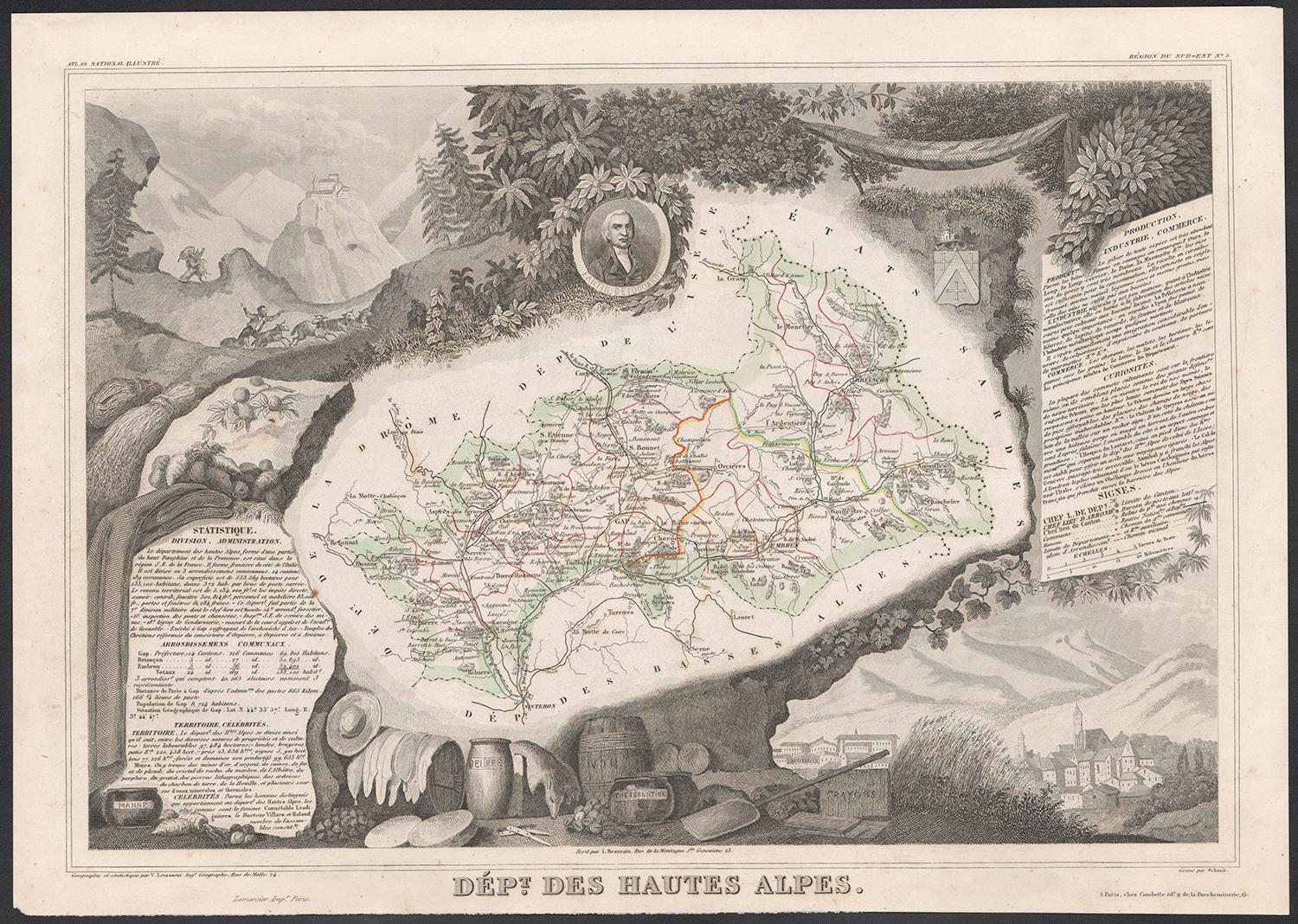
Map of Hautes-Alpes France with Gap and Alpine Scenery by Vuillemin, c.1850
120 €IVA inclusa
Informazioni sull’articolo
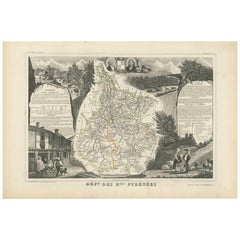
Map of Hautes-Alpes France with Gap and Alpine Scenery by Vuillemin
Description:
This elegant 19th-century map of the Hautes-Alpes department in southeastern France was created by Alexandre Vuillemin and published by Migeon in Paris as part of the richly illustrated Nouvel Atlas Illustré. The map presents a detailed view of this mountainous region, framed by artistic engravings that highlight its historical, topographical, and cultural significance.
Hautes-Alpes is one of the highest and most sparsely populated departments in France, located in the heart of the French Alps. The map is bordered with a soft hand-colored blue to indicate the departmental boundary. Towns, roads, and rivers are carefully engraved, and the mountainous terrain is subtly rendered with engraved shading. The map offers a close view of the towns of Gap, Embrun, Briançon, and the surrounding alpine passes that have long connected France and Italy.
At the upper left, a portrait of the Duc de Lesdiguières is featured. He was a key military leader in the Wars of Religion and the last Constable of France, born in the region and associated with its defense and development. In the upper right, a coat of arms appears with a fortified tower motif. The lower half of the sheet is dominated by an engraved vignette of Gap, the department’s prefecture, nestled in an idyllic alpine valley. Trees, livestock, and cottages contribute to the rural and peaceful atmosphere that characterizes this high-altitude area.
Though Hautes-Alpes is not a major wine-producing region due to its elevation and climate, it is known for small-scale, high-altitude viticulture in valleys such as those around Embrun and Tallard. More than its wine, however, the area is celebrated for winter sports, mountain tourism, and its stunning natural scenery. Hiking, skiing, and nature excursions are key to the region’s identity.
Alexandre Vuillemin was known for his skill in producing maps that were both accurate and decorative. His publisher, Migeon, brought these works to a wide audience through visually engaging atlases, combining educational and artistic appeal.
Condition summary:
Very good antique condition with only minor age-related foxing in the margins. Original hand-coloring is well preserved, and all engraved lines remain crisp and clear.
Framing tips:
This map would suit a natural wood frame or one with a distressed alpine finish. A cream or pale blue mat will complement the hand-colored border and evoke the cool tones of the mountain setting. Museum-quality glass is recommended for protection.
- Dimensioni:Altezza: 26,1 cm (10,28 in)Larghezza: 32,5 cm (12,8 in)Profondità: 0,2 mm (0,01 in)
- Materiali e tecniche:Carta,Inciso
- Luogo di origine:
- Periodo:
- Data di produzione:circa 1850
- Condizioni:Very good antique condition with only minor age-related foxing in the margins. Original hand-coloring is well preserved, and all engraved lines remain crisp and clear.
- Località del venditore:Langweer, NL
- Numero di riferimento:Venditore: BG-13331-51stDibs: LU3054345359152
Informazioni sul venditore
5,0
Venditore riconosciuto
Questi venditori prestigiosi sono leader del settore e rappresentano il massimo in termini di qualità e design.
Venditore Platino
Venditori Premium con valutazione 4.7+ e tempi di risposta entro 24 ore
Fondazione nel 2009
Venditore 1stDibs dal 2017
2609 vendite su 1stDibs
Tempo di risposta standard: <1 ora
- SpedizioneRecupero del preventivo…Spedizione da: Langweer, Paesi Bassi
- Politica di reso
Alcune parti di questa pagina sono state tradotte automaticamente. 1stDibs non può garantire che le traduzioni siano corrette. L’inglese è la lingua predefinita del sito.
Garanzia di autenticità
Nell’improbabile caso in cui si verifichi un problema con l’autenticità di un articolo, contattaci entro un anno per ottenere un rimborso completo. DettagliGaranzia di rimborso
Se il tuo articolo non corrisponde alla descrizione, è danneggiato durante il trasporto o non arriva, contattaci entro 7 giorni per un rimborso completo. DettagliAnnullamento entro 24 ore
Hai un periodo di tolleranza di 24 ore per annullare il tuo acquisto, senza necessità di fornire spiegazioni.Venditori professionali selezionati
I nostri venditori di livello internazionale devono aderire a rigorosi standard di servizio e qualità, garantendo l’integrità delle inserzioni.Garanzia miglior prezzo
Se scopri che un venditore ha pubblicato altrove lo stesso articolo a un prezzo più basso, applicheremo lo stesso prezzo.Consegna globale affidabile
La nostra rete di vettori leader del settore offre opzioni di spedizione specializzate in tutto il mondo, inclusa la consegna personalizzata.Altro da questo venditore
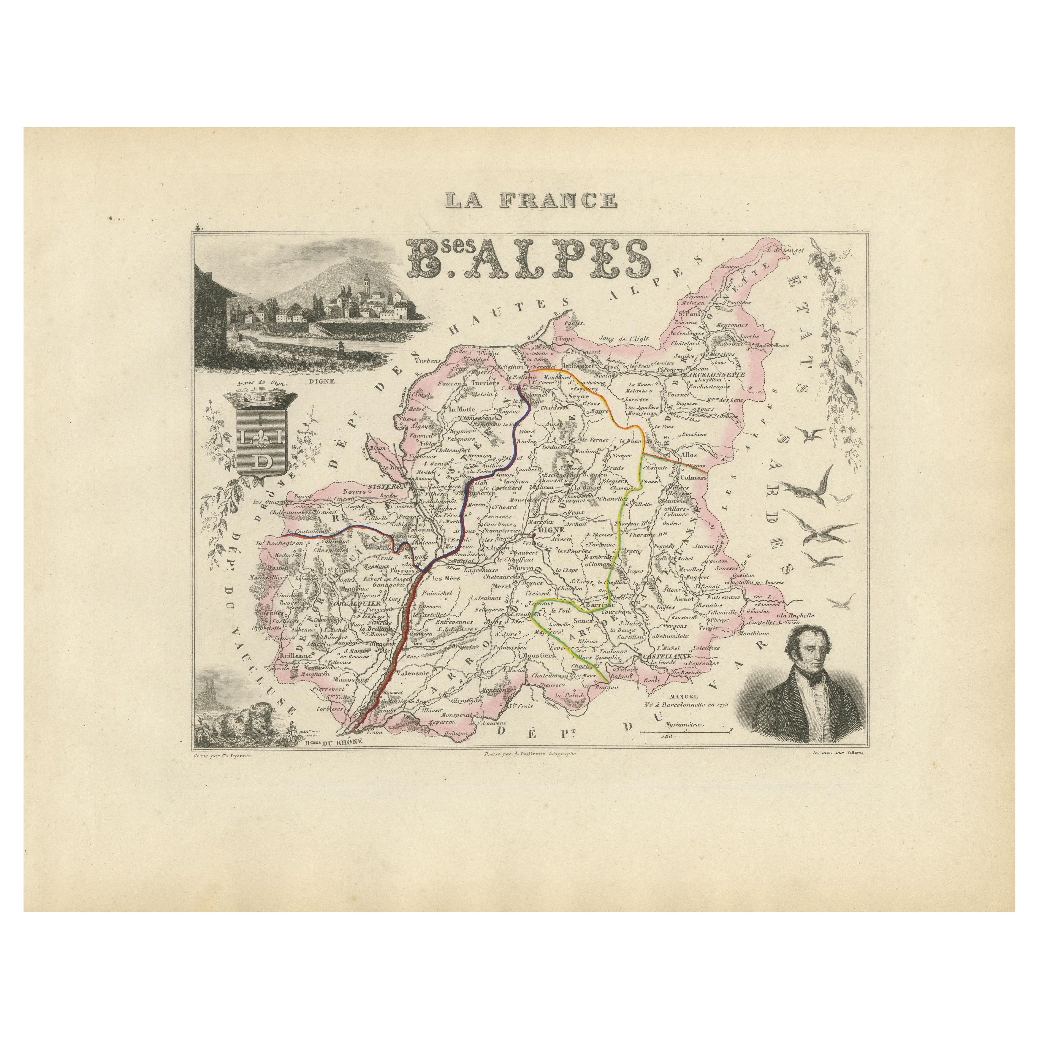
Mostra tuttoMap of Basses-Alpes France with Digne and Lavender Region by Vuillemin, c.1850
Map of Basses-Alpes France with Digne and Lavender Region by Vuillemin, 19th c
This finely engraved 19th-century map of the Basses-Alpes department of France (known today as Alpes-d...
Categoria
Di antiquariato/d’epoca, Metà XIX secolo, Francese, Mappe
Materiali
Carta
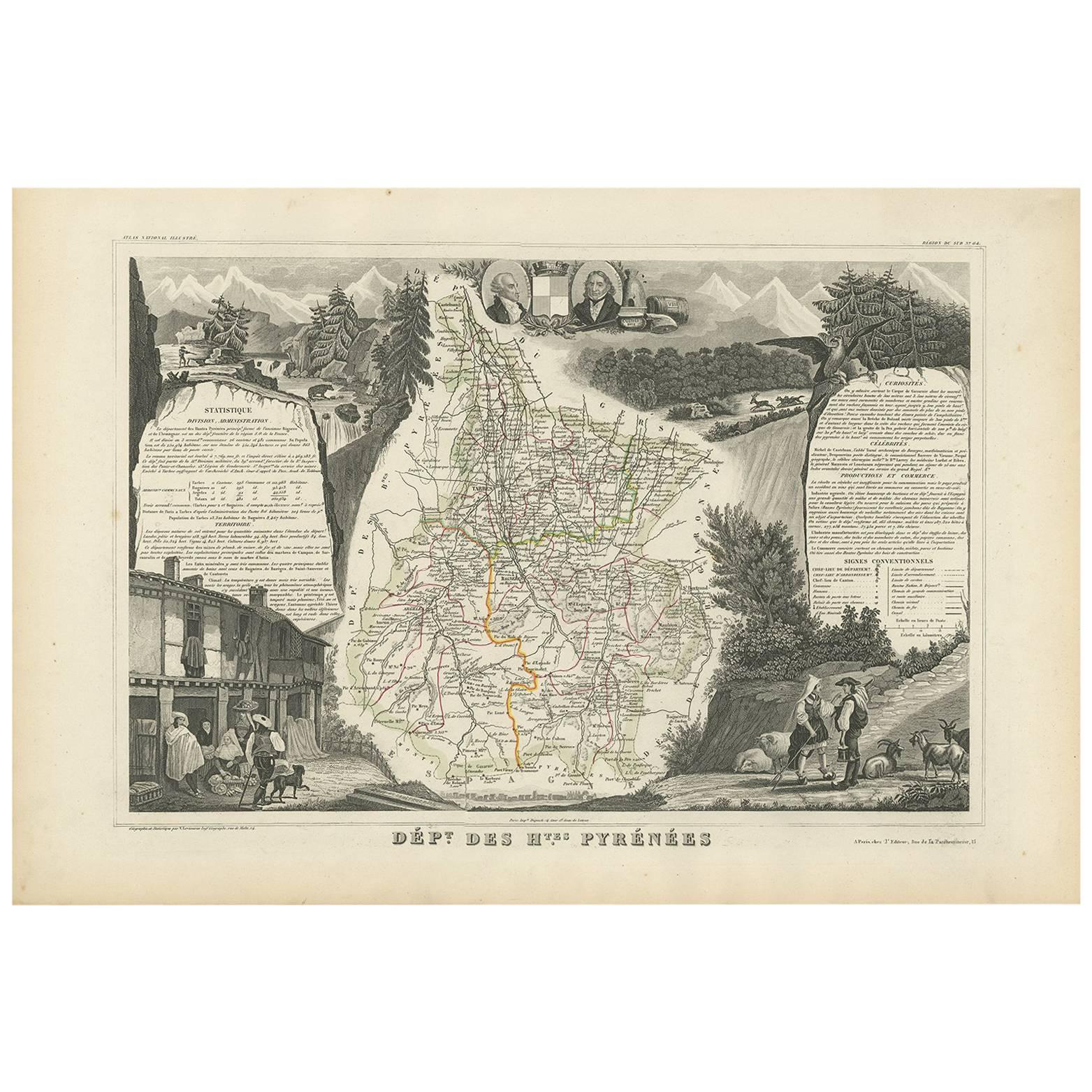
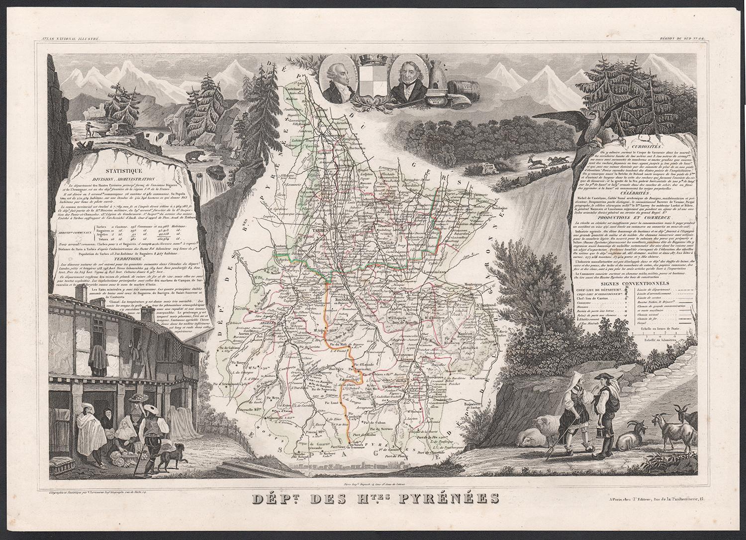
Carta geografica antica degli Hautes Pyrenees 'Francia' di V. Levasseur, 1854
Di Victor Levasseur
Carta geografica antica intitolata "Dépt. des Htes. Pirenei". Mappa del dipartimento francese degli Hautes Pyrenees, Francia. In quest'area si trova la regione produttrice di vino, M...
Categoria
Di antiquariato/d’epoca, Metà XIX secolo, Mappe
Materiali
Carta
160 € Prezzo promozionale
20% in meno
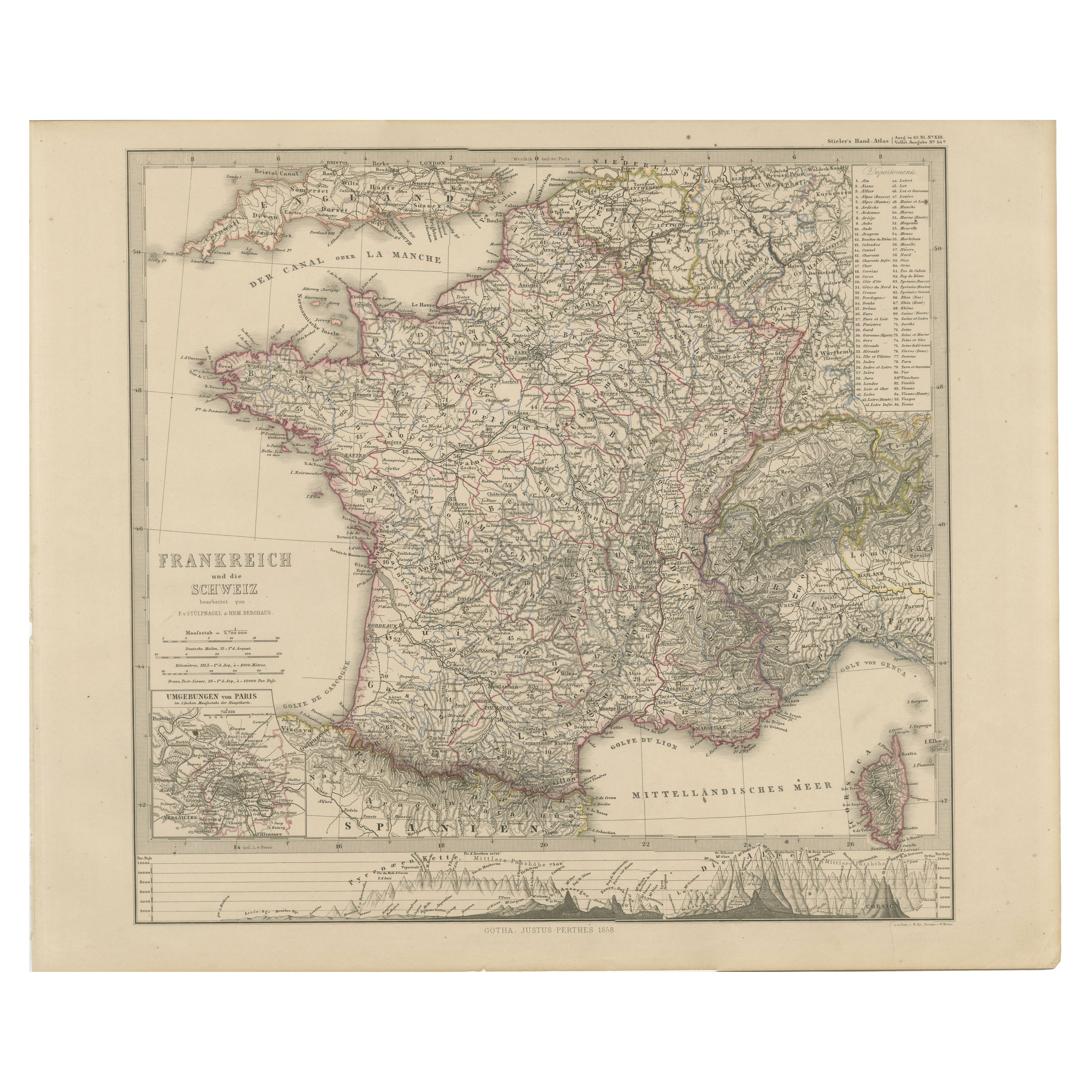
Carta della Francia e della Svizzera del 1856 con profili delle montagne
Carta della Francia e della Svizzera del 1856 con inserto di Parigi di Stülpnagel
Questa mappa antica di Francia e Svizzera, finemente dettagliata, è stata pubblicata nel 1856 dallo...
Categoria
Di antiquariato/d’epoca, Metà XIX secolo, Tedesco, Mappe
Materiali
Carta
Map of Allier France with Saint-Pourçain Wine Region by Vuillemin, 19th c
Map of Allier France with Saint-Pourçain Wine Region by Vuillemin, 19th c
This decorative 19th-century map of Allier, a central department of France, comes from the celebrated Nouve...
Categoria
Di antiquariato/d’epoca, Metà XIX secolo, Francese, Mappe
Materiali
Carta

Map of Côtes-du-Nord France with Saint-Brieuc and Brittany Coastline, c.1850
Map of Côtes-du-Nord France with Saint-Brieuc and Brittany Coastline, 19th c
Description:
This elegant 19th-century map of Côtes-du-Nord, the historic name for what is now known as ...
Categoria
Di antiquariato/d’epoca, Metà XIX secolo, Francese, Mappe
Materiali
Carta

Carta geografica antica della Francia di Lapie, 1842
Carta geografica antica intitolata "Carte de France". Mappa della Francia. Questa mappa proviene da "Atlas universel de géographie ancienne et moderne (...)" di Pierre M. Lapie e Ale...
Categoria
Di antiquariato/d’epoca, Metà XIX secolo, Mappe
Materiali
Carta

440 € Prezzo promozionale
20% in meno
Ti potrebbe interessare anche
Hautes Alpes, Francia. Mappa antica di un dipartimento francese, 1856
Di Victor Levasseur
Dept. des Hautes Alpes", incisione in acciaio con colorazione a mano dei contorni originali, 1856, da "Atlas National Illustre" di Levasseur.
Questa zona della Francia è nota per l...
Categoria
XIX secolo, Naturalismo, Stampe (paesaggio)
Materiali
Incisione

Alti Pirenei, Francia. Mappa antica di un dipartimento francese, 1856
Di Victor Levasseur
'Dept. des Hautes Pyrenees', incisione in acciaio con colorazione a mano dei contorni originali, 1856, dall'Atlas National Illustre di Levasseur.
In quest'area si trova la regione ...
Categoria
XIX secolo, Naturalismo, Stampe (paesaggio)
Materiali
Incisione

Mappa degli Hautes-Pyrénées - Litografia originale - XIX secolo
La Mappa degli Hautes-Pyrénées è una litografia originale realizzata da un incisore anonimo del XIX secolo.
Stampato in serie "France Pittoresque" in alto al centro.
Lo stato di co...
Categoria
XIX secolo, Moderno, Stampe figurative
Materiali
Carta, Litografia

Pirenei Orientali, Francia. Mappa antica di un dipartimento francese, 1856
Di Victor Levasseur
'Dept. des Pyrenees Orientales', incisione in acciaio con colorazione a mano dei contorni originali, 1856, da 'Atlas National Illustre' di Levasseur.
Quest'area è una nota regione ...
Categoria
XIX secolo, Naturalismo, Stampe (paesaggio)
Materiali
Incisione

Bella mappa antica del 1856, acquerellata a mano, del Dipartimento delle Hautes Alpes di Levasseur
Siamo lieti di offrire in vendita questa splendida mappa ad acquerello del 1856 delle Alpi austriache, intitolata Dept Des Hautes Alpes, tratta dall'Atlas National Illustre y Victor ...
Categoria
Di antiquariato/d’epoca, Anni 1850, Francese, Primo vittoriano, Mappe
Materiali
Carta

617 € Prezzo promozionale
30% in meno
Lozere, Francia. Mappa antica di un dipartimento francese, 1856
Di Victor Levasseur
'Dept. de La Lozere', incisione in acciaio con colorazione a mano dei contorni originali, 1856, da 'Atlas National Illustre' di Levasseur.
Questa remota zona montuosa della Linguad...
Categoria
XIX secolo, Naturalismo, Stampe (paesaggio)
Materiali
Incisione
