Articoli simili a Map of Languedoc by Willem Blaeu, Antique French Copper Engraving 1635


Vuoi altre immagini o video?
Richiedi altre immagini o video al venditore
1 di 10
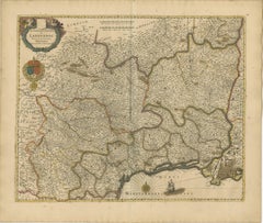
Map of Languedoc by Willem Blaeu, Antique French Copper Engraving 1635
950 €IVA inclusa
Informazioni sull’articolo
Map of Languedoc by Willem Blaeu, Antique French Copper Engraving 1635
This fine antique map titled "Langvedoc" depicts the historical province of Languedoc in southern France and was produced by Willem Blaeu, one of the most celebrated Dutch cartographers of the 17th century. Originally published in 1631, this specific edition dates from 1635 and was issued as part of Blaeu’s renowned atlas series, Theatrum Orbis Terrarum.
Engraved in copper and delicately hand-colored, the map showcases the region's complex network of towns, rivers, mountain ranges, and coastline along the Mediterranean Sea. Notable cities such as Montpellier, Nîmes, Béziers, and Carcassonne are clearly marked. The level of detail reflects both the cartographic skill and aesthetic ambition of the Blaeu publishing house.
The map is enriched with decorative elements typical of the period, including a large ornate title cartouche at upper left, flanked by cherubs and scrollwork. Beneath the cartouche, the royal coat of arms of France is prominently displayed, colored in vivid red, gold, and blue, underscoring the political affiliation of the region during the reign of Louis XIII. A mileage scale in the upper center and a compass rose in the Mediterranean further enhance the navigational and ornamental qualities of the work. A sailing ship adds charm and visual interest to the sea section.
Willem Blaeu, active in Amsterdam, was a master printer, publisher, and globe maker. His maps were not only among the most accurate of his time but also the most beautiful, combining scientific precision with artistic elegance. This map would have been included in an early Blaeu atlas, valued for both its information and its aesthetic appeal.
This is an exceptional example of early French regional cartography, ideal for collectors of antique maps or those with a connection to the Languedoc region.
Condition:
Good condition with age-toned paper, mainly edge wear, touching the image but mostly outside the plate mark. Old folds as issued.
Tips for Framing:
Best displayed in a classic gold or natural wood frame with an ivory or parchment-tone mat to complement the warm patina and hand-coloring of the map.
- Dimensioni:Altezza: 49 cm (19,3 in)Larghezza: 58,6 cm (23,08 in)Profondità: 0,02 mm (0 in)
- Materiali e tecniche:Carta,Inciso
- Periodo:1630-1639
- Data di produzione:circa 1635
- Condizioni:Engraving with original hand coloring. Good condition with age-toned paper, mainly edge wear, touching the image but mostly outside the plate mark. Old folds as issued. Study the images carefully.
- Località del venditore:Langweer, NL
- Numero di riferimento:Venditore: BG-13732-41stDibs: LU3054345364182
Informazioni sul venditore
5,0
Venditore riconosciuto
Questi venditori prestigiosi sono leader del settore e rappresentano il massimo in termini di qualità e design.
Venditore Platino
Venditori Premium con valutazione 4.7+ e tempi di risposta entro 24 ore
Fondazione nel 2009
Venditore 1stDibs dal 2017
2604 vendite su 1stDibs
Tempo di risposta standard: <1 ora
- SpedizioneRecupero del preventivo…Spedizione da: Langweer, Paesi Bassi
- Politica di reso
Alcune parti di questa pagina sono state tradotte automaticamente. 1stDibs non può garantire che le traduzioni siano corrette. L’inglese è la lingua predefinita del sito.
Garanzia di autenticità
Nell’improbabile caso in cui si verifichi un problema con l’autenticità di un articolo, contattaci entro un anno per ottenere un rimborso completo. DettagliGaranzia di rimborso
Se il tuo articolo non corrisponde alla descrizione, è danneggiato durante il trasporto o non arriva, contattaci entro 7 giorni per un rimborso completo. DettagliAnnullamento entro 24 ore
Hai un periodo di tolleranza di 24 ore per annullare il tuo acquisto, senza necessità di fornire spiegazioni.Venditori professionali selezionati
I nostri venditori di livello internazionale devono aderire a rigorosi standard di servizio e qualità, garantendo l’integrità delle inserzioni.Garanzia miglior prezzo
Se scopri che un venditore ha pubblicato altrove lo stesso articolo a un prezzo più basso, applicheremo lo stesso prezzo.Consegna globale affidabile
La nostra rete di vettori leader del settore offre opzioni di spedizione specializzate in tutto il mondo, inclusa la consegna personalizzata.Altro da questo venditore
Mostra tuttoSplendida mappa colorata a mano della Linguadoca in Francia di Frederik De Wit del 1688 ca.
Titolo: Splendida mappa colorata a mano della Linguadoca di Frederik De Wit del 1688 circa
Descrizione: Questa elegante mappa del XVII secolo, "Gouvernement General de Languedoc", i...
Categoria
Di antiquariato/d’epoca, Anni 1680, Mappe
Materiali
Carta
Mappa di Blaisois di Janssonius, 1633, Carta geografica antica decorativa della Valle della Loira
Mappa di Blaisois di Janssonius, 1633, Carta geografica antica decorativa della Valle della Loira
Questa mappa finemente dettagliata e colorata, intitolata "Description du Blaisois"...
Categoria
Di antiquariato/d’epoca, Anni 1630, Mappe
Materiali
Carta
Mappa della Provenza nel Southern France, antica incisione originale di De Wit del 1688 ca.
Titolo: Mappa della Provenza - Incisione colorata a mano del XVII secolo di Frederik De Wit, 1688 ca.
Descrizione: Questa accattivante mappa, "Gouvernement de Provence", raffigura l...
Categoria
Di antiquariato/d’epoca, Anni 1680, Mappe
Materiali
Carta
Bellissima mappa del XVII secolo di Parigi e dell'Isola di Francia di Templeux, 1650 ca.
Mappa dell'Isola di Francia di D. A. de Templeux, 1650 circa, colorata a mano e decorativa
Questa mappa antica ricca di dettagli intitolata *Le Gouvernement de L'Isle de France* è s...
Categoria
Di antiquariato/d’epoca, Anni 1650, Mappe
Materiali
Carta

Carta geografica antica della Catalogna di Blaeu, 1650 circa
Carta geografica antica intitolata "Catalogna". Carta geografica antica della Catalogna, che si estende da C. De Romani sulla costa settentrionale fino ad Alfachs e Panicola a Valenc...
Categoria
Di antiquariato/d’epoca, Metà XVII secolo, Mappe
Materiali
Carta

720 € Prezzo promozionale
20% in meno
Carta geografica antica della regione di Lione di Hondius, 1630 circa
Carta geografica antica intitolata "Lionnois, Forest et Beauiolois". Antica mappa dell'ex regione di Lione, Vienne, Bresse, Rohan e del fiume Rodano. Questa mappa proviene da un atla...
Categoria
Di antiquariato/d’epoca, Metà XVII secolo, Mappe
Materiali
Carta

400 € Prezzo promozionale
20% in meno
Ti potrebbe interessare anche
1635 Willem Blaeu Mappa della Francia settentrionale "Comitatvs Bellovacvm" Ric.a08
Mappa del 1635 di Willem Blaeu della Francia settentrionale, intitolata.
"Comitatvs Bellovacvm Vernacule Beavvais".
Colorato
Ric.a008
"COMITATVS BELLOVACVM..." Amsterdam: Wil...
Categoria
Di antiquariato/d’epoca, XVII secolo, Sconosciuto, Mappe
Materiali
Carta

1640 Carta di Joan Bleau intitolata "Diocecese de rheims et le pais de rethel, " Eic.a011
1640 Mappa di Joan Bleau intitolata
"Diocecese di Reims e il paese di Rethel".
Ric.a011
OAN BLAEU
Diocecese di Reims e il paese di Rethel.
Incisione colorata a mano, 1...
Categoria
Di antiquariato/d’epoca, XVII secolo, Olandese, Mappe
Materiali
Carta

Mappa di Mercatore del 1625 della provenienza del Quercy, "Quercy Cadvrcivm Ric.0013
Mappa di Mercatore del 1625 della provenienza del Quercy, intitolata
"Quercy Cadvrcivm".
Ric.0013
" Autentica" - Mappa della provenienza di Quercy Cadvrcivm
Descrizione: Car...
Categoria
Di antiquariato/d’epoca, XVII secolo, Francese, Mappe
Materiali
Carta

Carta geografica antica - Gallia - Acquaforte di Johannes Janssonius - 1650
Di Johannes Janssonius
Mappa antica - Gallia è una mappa antica realizzata nel 1650 da Johannes Janssonius (1588-1664).
La mappa è un'acquaforte colorata a mano, con acquerello coevo.
Buone condizioni co...
Categoria
Anni 1650, Moderno, Stampe figurative
Materiali
Acquaforte

1656 Jansson Mappa della regione francese di Metz intitolata "Territorium Metense" Ric0014
1656 Jansson mappa la regione di Metz in Francia intitolata "Territorium Metense".
Ric0014
" Autentica" - Mappa della regione storica che circonda Metz, in Lorena, Francia.
Ori...
Categoria
Di antiquariato/d’epoca, XVII secolo, Olandese, Mappe
Materiali
Carta

Carta geografica antica - Macedonia - Acquaforte di Johannes Janssonius - 1650
Di Johannes Janssonius
La Macedonia è un'antica mappa realizzata nel 1650 da Johannes Janssonius (1588-1664).
La mappa è un'acquaforte colorata a mano, con acquerello coevo.
Buone condizioni con leggero ...
Categoria
Anni 1650, Moderno, Stampe figurative
Materiali
Acquaforte
