Articoli simili a Map of the Southeastern USA and Atlantic States – Vintage 1903 Geography
Vuoi altre immagini o video?
Richiedi altre immagini o video al venditore
1 di 10
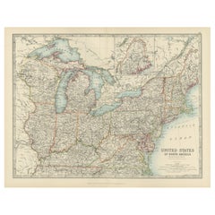
Map of the Southeastern USA and Atlantic States – Vintage 1903 Geography
Informazioni sull’articolo
Map of the Southeastern USA and Atlantic States – Vintage 1903 Geography
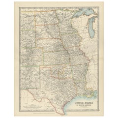
This original engraved map, titled “United States of North America (South Eastern Sheet) with the Atlantic States,” was meticulously prepared by Keith Johnston and published in the early 1900s. It offers an intricately detailed representation of the southeastern region of the United States, including the Gulf of Mexico, the southern Atlantic coast, and the states of Georgia, Alabama, Mississippi, Louisiana, Florida, South Carolina, North Carolina, Tennessee, and beyond. An inset map captures the urban areas of Boston and Philadelphia with fine clarity, providing additional historical perspective on these prominent cities during the early 20th century.
The cartographic detail is impressive, showcasing not only state boundaries but also county divisions, major railroads, rivers, and mountain ranges, all in beautifully engraved lines with color outlining the states. The typography is precise and easy to read, adding a decorative touch to the map’s historical character. With the Atlantic Ocean labeled in classic script and the inclusion of neighboring Bahama Islands, this map gives a comprehensive view of trade routes and maritime significance during that period.
Condition is excellent for its age, with only minor aging or marginal imperfections that do not detract from its presentation. The engraved lines and colored boundaries remain vivid, offering a crisp visual appeal perfect for display or collection.
This map would look splendid framed in a classic or antique-style wooden frame, perhaps with a warm, natural finish to complement the vintage aesthetic. For the mat, consider cream or off-white to highlight the fine engraving. Ideal for anyone with a passion for American history, cartography, or antique décor, this map stands as both a piece of art and a window into the past.
- Dimensioni:Altezza: 36,8 cm (14,49 in)Larghezza: 47 cm (18,51 in)Profondità: 0,2 mm (0,01 in)
- Materiali e tecniche:
- Periodo:
- Data di produzione:1903
- Condizioni:Condition is excellent for its age, with only minor aging or marginal imperfections that do not detract from its presentation. The engraved lines and colored boundaries remain vivid, offering a crisp visual appeal perfect for display or collection.
- Località del venditore:Langweer, NL
- Numero di riferimento:Venditore: BG-13577-461stDibs: LU3054345291802
Informazioni sul venditore
5,0
Venditore riconosciuto
Questi venditori prestigiosi sono leader del settore e rappresentano il massimo in termini di qualità e design.
Venditore Oro
Venditori Premium con valutazione 4,3+ e tempi di risposta entro 24 ore
Fondazione nel 2009
Venditore 1stDibs dal 2017
2.462 vendite su 1stDibs
Tempo di risposta standard: <1 ora
- SpedizioneRecupero del preventivo…Spedizione da: Langweer, Paesi Bassi
- Politica di reso
Alcune parti di questa pagina sono state tradotte automaticamente. 1stDibs non può garantire che le traduzioni siano corrette. L’inglese è la lingua predefinita del sito.
Garanzia di autenticità
Nell’improbabile caso in cui si verifichi un problema con l’autenticità di un articolo, contattaci entro un anno per ottenere un rimborso completo. DettagliGaranzia di rimborso
Se il tuo articolo non corrisponde alla descrizione, è danneggiato durante il trasporto o non arriva, contattaci entro 7 giorni per un rimborso completo. DettagliAnnullamento entro 24 ore
Hai un periodo di tolleranza di 24 ore per annullare il tuo acquisto, senza necessità di fornire spiegazioni.Venditori professionali selezionati
I nostri venditori di livello internazionale devono aderire a rigorosi standard di servizio e qualità, garantendo l’integrità delle inserzioni.Garanzia miglior prezzo
Se scopri che un venditore ha pubblicato altrove lo stesso articolo a un prezzo più basso, applicheremo lo stesso prezzo.Consegna globale affidabile
La nostra rete di vettori leader del settore offre opzioni di spedizione specializzate in tutto il mondo, inclusa la consegna personalizzata.Altro da questo venditore
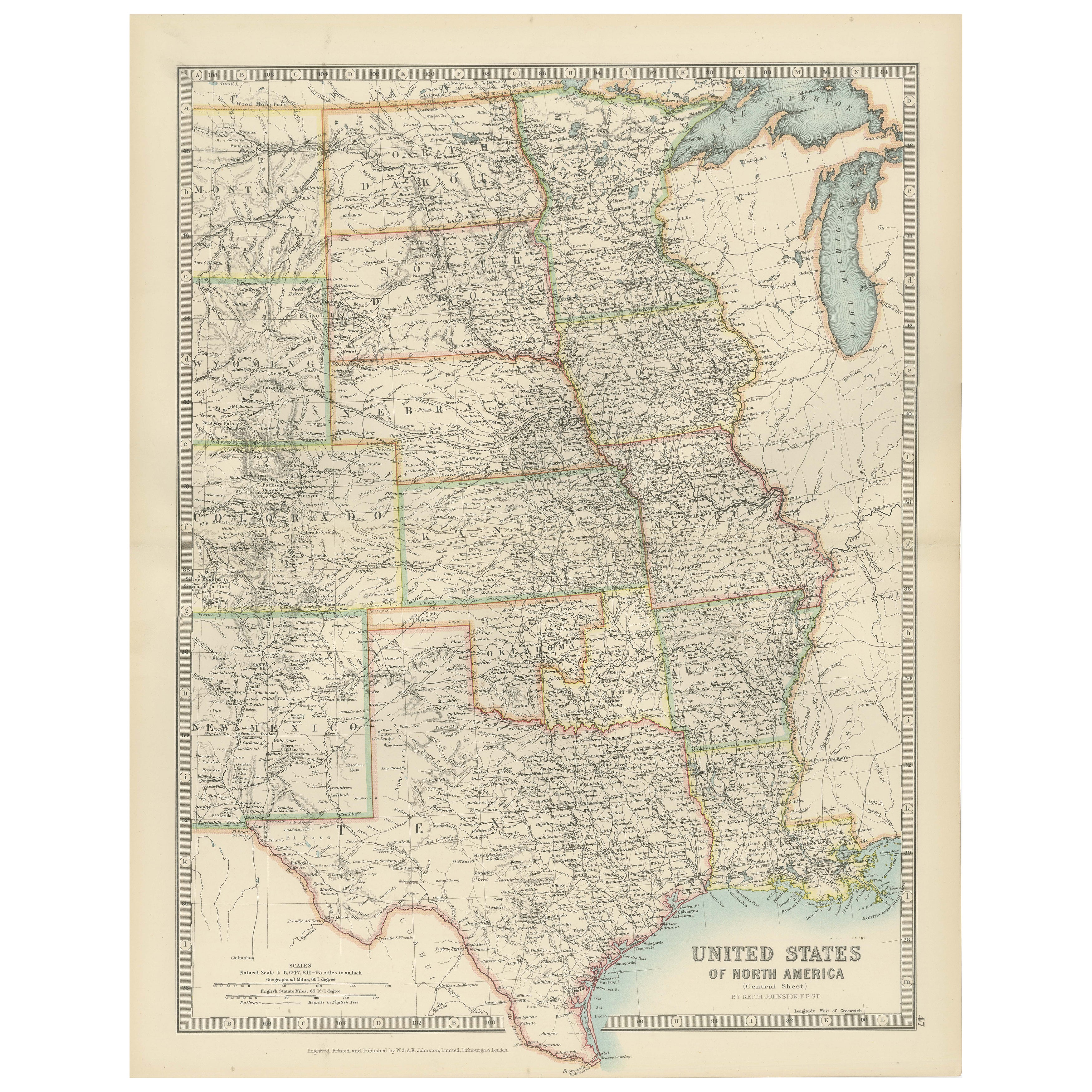
Mostra tuttoMap of United States Central Sheet 1903 – Railroads, States, and Topography
Map of United States Central Sheet 1903 – Railroads, States, and Topography
This is a finely engraved and beautifully colored map titled "United States of North America (Central She...
Categoria
Inizio XX secolo, Mappe
Materiali
Carta
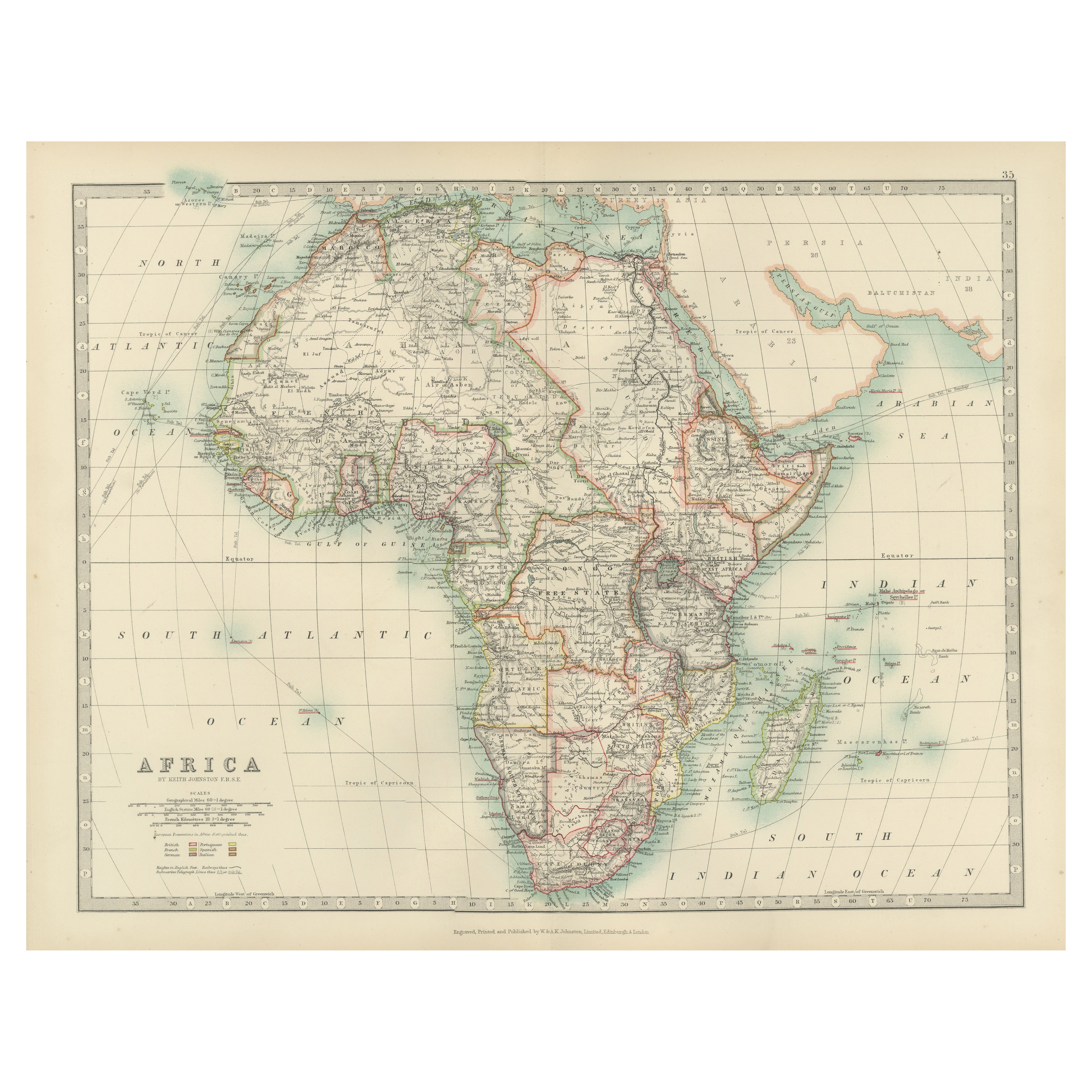
Antique Map of Africa, Highlighting Colonial Divisions, Geographic Features 1903
Title: Antique Map of Africa, 1903, Highlighting Colonial Divisions and Geographic Features
Description: This antique map, titled "Africa," was engraved and published in 1903 by W. ...
Categoria
Inizio XX secolo, Mappe
Materiali
Carta
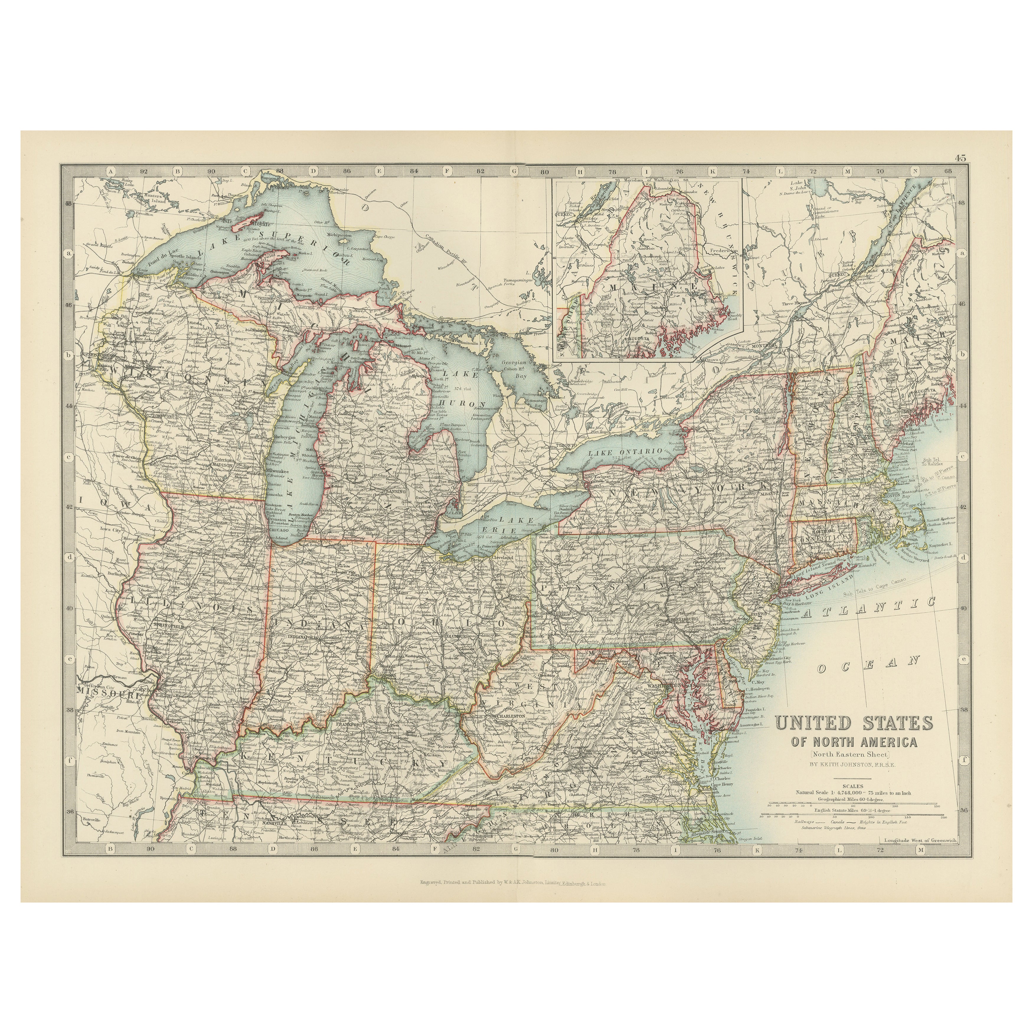
Antique Map of the Northeast USA - Vibrant 1903 Cartographic Detail
Map of the Northeastern United States of North America, 1903
This striking antique map titled “United States of North America (North Eastern Sheet)” was created by the renowned Scot...
Categoria
Inizio XX secolo, Mappe
Materiali
Carta
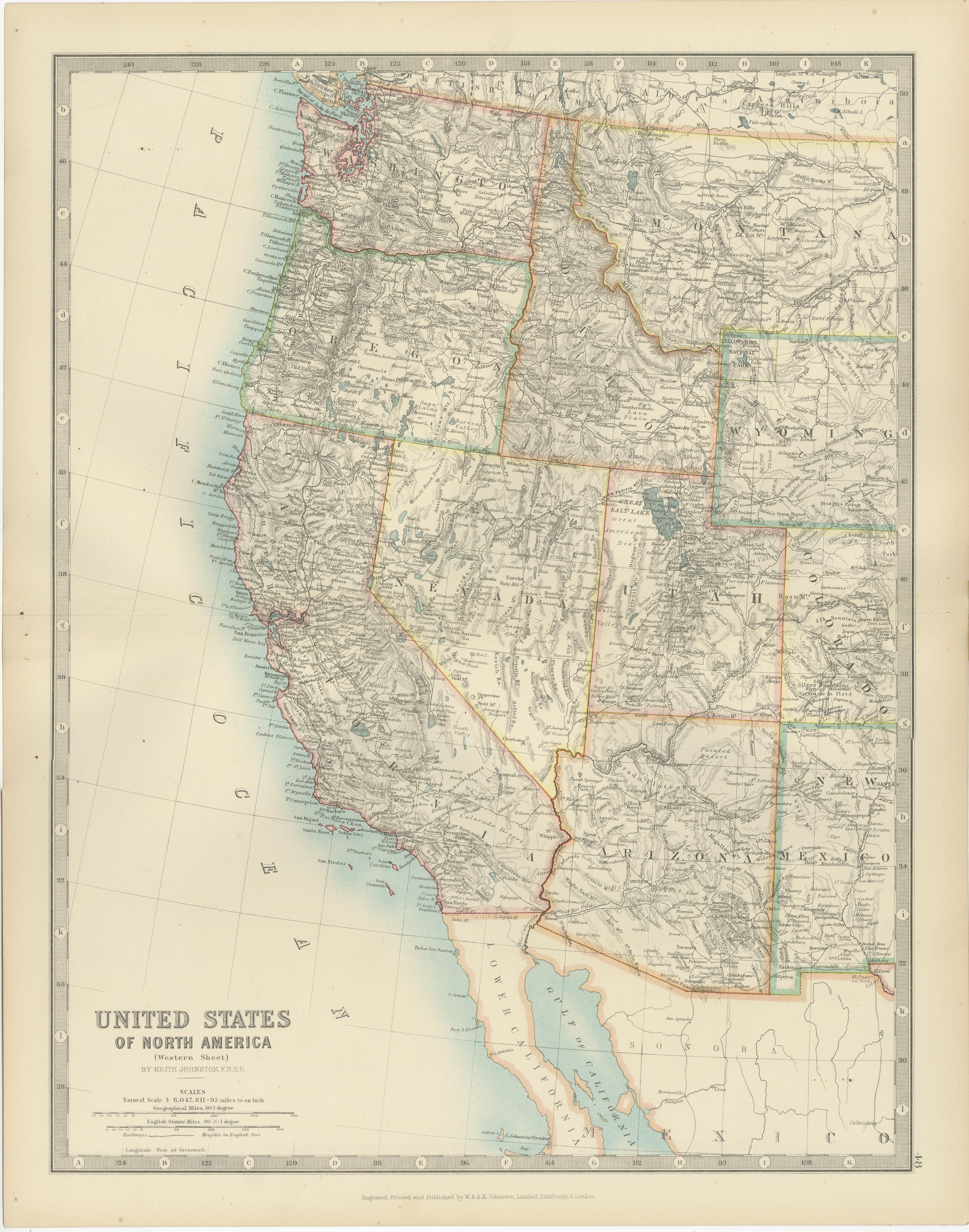
Map of Western United States 1903 – Railroads, State Borders, and Terrain
Map of Western United States 1903 – Railroads, State Borders, and Terrain
This beautifully engraved map titled "United States of North America (Western Sheet)" was created by Keith ...
Categoria
Inizio XX secolo, Mappe
Materiali
Carta

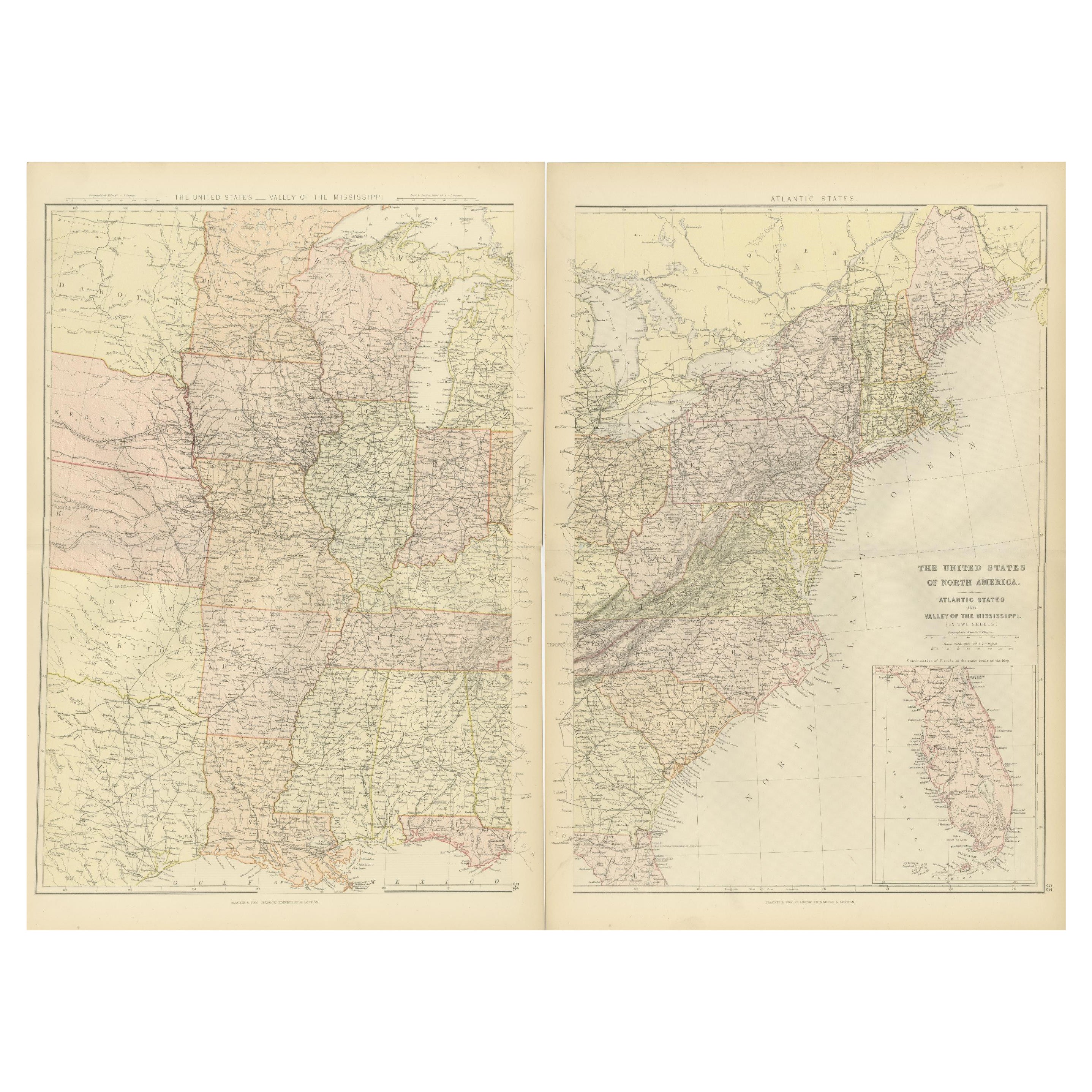
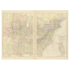
Atlante Blackie del 1882: Compilazione degli Stati dell'Atlantico e della Valle del Mississippi
Queste due mappe tratte dall'Atlante Blackie del 1882 forniscono una visione dettagliata della metà orientale degli Stati Uniti, evidenziando le principali caratteristiche geografich...
Categoria
Di antiquariato/d’epoca, Anni 1880, Mappe
Materiali
Carta
Piccola mappa degli Stati Uniti
Carta geografica antica intitolata 'Amérique septe. Fisico". Piccola mappa degli Stati Uniti. litografata dai fratelli C. Callewaert a Bruxelles nel 1870 circa.
Categoria
Di antiquariato/d’epoca, Metà XIX secolo, Mappe
Materiali
Carta

70 USD Prezzo promozionale
20% in meno
Ti potrebbe interessare anche
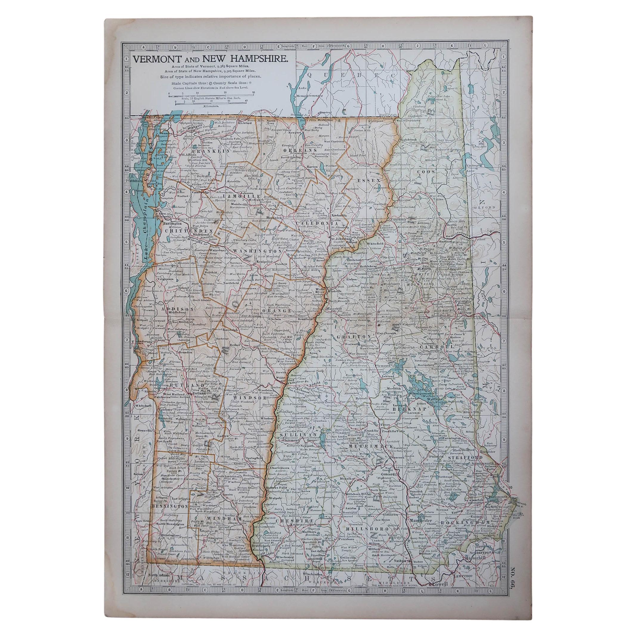
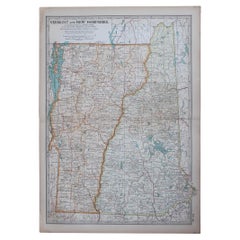
Mappa antica originale degli Stati americani del Vermont &New Hampshire, 1903
Antique map of Vermont and New Hampshire
Published By A & C Black. 1903
Original colour
Good condition
Unframed.
Free shipping
Categoria
Di antiquariato/d’epoca, Inizio Novecento, Inglese, Mappe
Materiali
Carta
49 USD
Spedizione gratuita
Grandi mappe d'epoca degli Stati Uniti, in 3 sezioni, 1920
Grandi mappe degli Stati Uniti in 3 sezioni
Non incorniciato
Colore originale
Da John Bartholomew and Co. Istituto Geografico di Edimburgo
Pubblicato, circa 1920
Le misure indic...
Categoria
Vintage, Anni 1920, Britannico, Mappe
Materiali
Carta

Mappa geografica antica del Principato di Monaco
Di Bruno Santini
ST/609 - Interessante carta geografica d'epoca a colori del Principato di Monaco in lingua francese: "Carte qui contient le Principauté de Piémont, le Monferrat et la comté de Nice a...
Categoria
Di antiquariato/d’epoca, Fine XVIII secolo, Italiano, Altro, Mappe
Materiali
Carta

Mappa degli Stati Uniti con cornice vintage
Mappa degli Stati Uniti in carta invecchiata d'epoca montata su pannello di particelle e incorniciata in una semplice cornice di legno.
Categoria
XX secolo, Americano, Mid-Century moderno, Mappe
Materiali
Legno, Carta

Mappa dell'Europa sud-orientale di Nicolas Visscher del XVII secolo
Una bellissima e dettagliatissima mappa dell'Europa sud-orientale di Nicolas Visscher. Include le regioni dell'Italia settentrionale (con le città di Bologna, Padova e Venezia), Boem...
Categoria
Di antiquariato/d’epoca, XVII secolo, Olandese, Mappe
Materiali
Carta

1.350 USD Prezzo promozionale
38% in meno
Mappa antica originale dello Stato americano del Minnesota, 1903
Mappa antica del Minnesota
Pubblicato da A.I.C. Black. 1903
Colore originale
Buono stato
Senza cornice.
Spedizione gratuita
Categoria
Di antiquariato/d’epoca, Inizio Novecento, Inglese, Mappe
Materiali
Carta
