Articoli simili a Map of the West India Islands and Central America – Colorful 1903 Engraving


Vuoi altre immagini o video?
Richiedi altre immagini o video al venditore
1 di 10
Map of the West India Islands and Central America – Colorful 1903 Engraving
Informazioni sull’articolo
Map of the West India Islands and Central America – Colorful 1903 Engraving
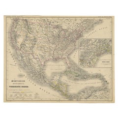
This vibrant engraved map, titled "West India Islands and Central America," was created by Keith Johnston, F.R.G.S., and published by W. & A.K. Johnston, Limited, Edinburgh & London, in 1903. The map offers a detailed depiction of the Caribbean region and Central America at the dawn of the 20th century, skillfully blending geographic accuracy with artistic charm.
The map captures the entire Caribbean basin, stretching from the southern tip of Florida to the shores of South America. It includes the major islands of Cuba, Hispaniola, Jamaica, Puerto Rico, the Bahamas, the Lesser Antilles, and parts of Central America like the Yucatán Peninsula, Honduras, Nicaragua, Costa Rica, and Panama. Intricately engraved lines represent the coastlines, rivers, and mountain ranges, while soft pastel color washes highlight the different political regions, adding clarity and elegance to the visual composition.
An essential feature is the precise labeling of key cities, settlements, and natural landmarks, reflecting the colonial influences and strategic importance of these islands. The map also delineates ocean currents, islands, and smaller cays that were crucial for trade, navigation, and exploration in this era.
This piece stands out not only for its visual appeal but also for its historical significance, marking a time of shifting colonial powers and growing global trade across the Atlantic and Pacific Oceans. T
The condition of this antique map is excellent, with vibrant color retention, clear typography, and minimal wear along the edges.
For framing, a dark wood or sleek black frame with a neutral mat would elegantly complement the delicate engravings and vibrant colors, making this map a striking addition to a study, library, or coastal home. It’s a compelling artifact of exploration and trade routes that shaped the modern Caribbean and Central America, offering a rich narrative for collectors, historians, or anyone fascinated by the region’s dynamic history.
- Dimensioni:Altezza: 47 cm (18,51 in)Larghezza: 36,8 cm (14,49 in)Profondità: 0,2 mm (0,01 in)
- Materiali e tecniche:
- Periodo:
- Data di produzione:1903
- Condizioni:The condition of this antique map is excellent, with vibrant color retention, clear typography, and minimal wear along the edges.
- Località del venditore:Langweer, NL
- Numero di riferimento:Venditore: BG-13577-491stDibs: LU3054345292032
Informazioni sul venditore
5,0
Venditore riconosciuto
Questi venditori prestigiosi sono leader del settore e rappresentano il massimo in termini di qualità e design.
Venditore Oro
Venditori Premium con valutazione 4,3+ e tempi di risposta entro 24 ore
Fondazione nel 2009
Venditore 1stDibs dal 2017
2.462 vendite su 1stDibs
Tempo di risposta standard: <1 ora
- SpedizioneRecupero del preventivo…Spedizione da: Langweer, Paesi Bassi
- Politica di reso
Alcune parti di questa pagina sono state tradotte automaticamente. 1stDibs non può garantire che le traduzioni siano corrette. L’inglese è la lingua predefinita del sito.
Garanzia di autenticità
Nell’improbabile caso in cui si verifichi un problema con l’autenticità di un articolo, contattaci entro un anno per ottenere un rimborso completo. DettagliGaranzia di rimborso
Se il tuo articolo non corrisponde alla descrizione, è danneggiato durante il trasporto o non arriva, contattaci entro 7 giorni per un rimborso completo. DettagliAnnullamento entro 24 ore
Hai un periodo di tolleranza di 24 ore per annullare il tuo acquisto, senza necessità di fornire spiegazioni.Venditori professionali selezionati
I nostri venditori di livello internazionale devono aderire a rigorosi standard di servizio e qualità, garantendo l’integrità delle inserzioni.Garanzia miglior prezzo
Se scopri che un venditore ha pubblicato altrove lo stesso articolo a un prezzo più basso, applicheremo lo stesso prezzo.Consegna globale affidabile
La nostra rete di vettori leader del settore offre opzioni di spedizione specializzate in tutto il mondo, inclusa la consegna personalizzata.Altro da questo venditore
Mostra tuttoCarta geografica antica dell'America Centrale e delle Indie Occidentali, 1882
Carta geografica antica intitolata "Isole delle Indie Occidentali e America Centrale". Antica mappa dell'America Centrale e delle Indie Occidentali. Questa mappa proviene da "The Roy...
Categoria
Di antiquariato/d’epoca, XIX secolo, Mappe
Materiali
Carta

167 USD Prezzo promozionale
20% in meno
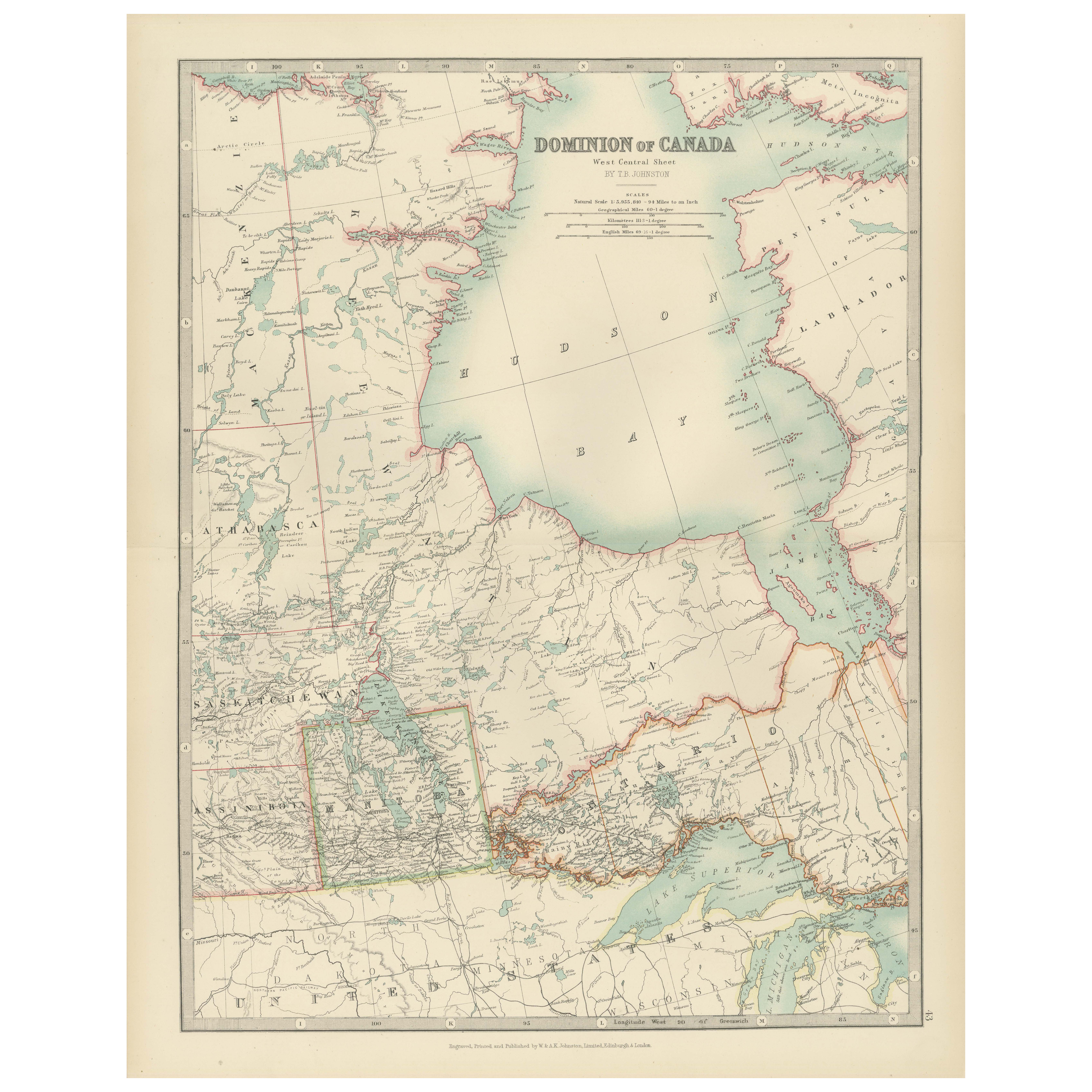
Canada Map 1903 - Dominion of Canada, West Central Sheet
Title: Canada Map 1903 - Dominion of Canada, West Central Sheet
Description:
This fascinating 1903 map of the Dominion of Canada’s West Central regions by T.R. Johnston offers a viv...
Categoria
Inizio XX secolo, Mappe
Materiali
Carta
Carta geografica antica delle Indie Occidentali e dell'America Centrale di Lowry del 1852
Carta geografica antica intitolata "Indie occidentali e America centrale". Mappa originale delle Indie Occidentali e dell'America Centrale. Questa mappa proviene da 'Lowry's Table At...
Categoria
Di antiquariato/d’epoca, Metà XIX secolo, Mappe
Materiali
Carta

93 USD Prezzo promozionale
20% in meno
Carta geografica antica delle Indie Occidentali e dell'America Centrale di W. G. Blackie, 1859
Carta geografica antica intitolata "Le isole dell'India occidentale e l'America centrale". Mappa antica originale delle Indie Occidentali e dell'America Centrale, con inserto della G...
Categoria
Di antiquariato/d’epoca, Metà XIX secolo, Mappe
Materiali
Carta

232 USD Prezzo promozionale
20% in meno
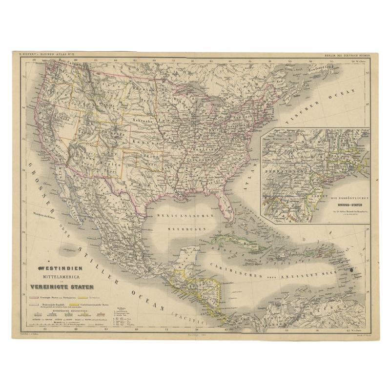
Antica mappa tedesca degli Stati Uniti, dell'America Centrale e delle Indie Occidentali, 1870 ca.
Carta geografica antica intitolata "Westindien, Mittelamerica und Vereinigte Staten". Antica mappa degli Stati Uniti, dell'America Centrale e delle Indie Occidentali. Questa mappa pr...
Categoria
Di antiquariato/d’epoca, XIX secolo, Mappe
Materiali
Carta
Incisione di una mappa della Florida, della costa del Golfo, dei Caraibi e dell'America Centrale, 1728
Questa eccezionale mappa antica, intitolata "Nouvelle Carte Marin de Toute les Cotes de l'Amerique" e conosciuta in alternativa come "Nieuwe groote en seer Curieuse Paskaart van Gehe...
Categoria
Di antiquariato/d’epoca, Metà XVIII secolo, Europeo, Mappe
Materiali
Carta

12.744 USD Prezzo promozionale
26% in meno
Spedizione gratuita
Ti potrebbe interessare anche
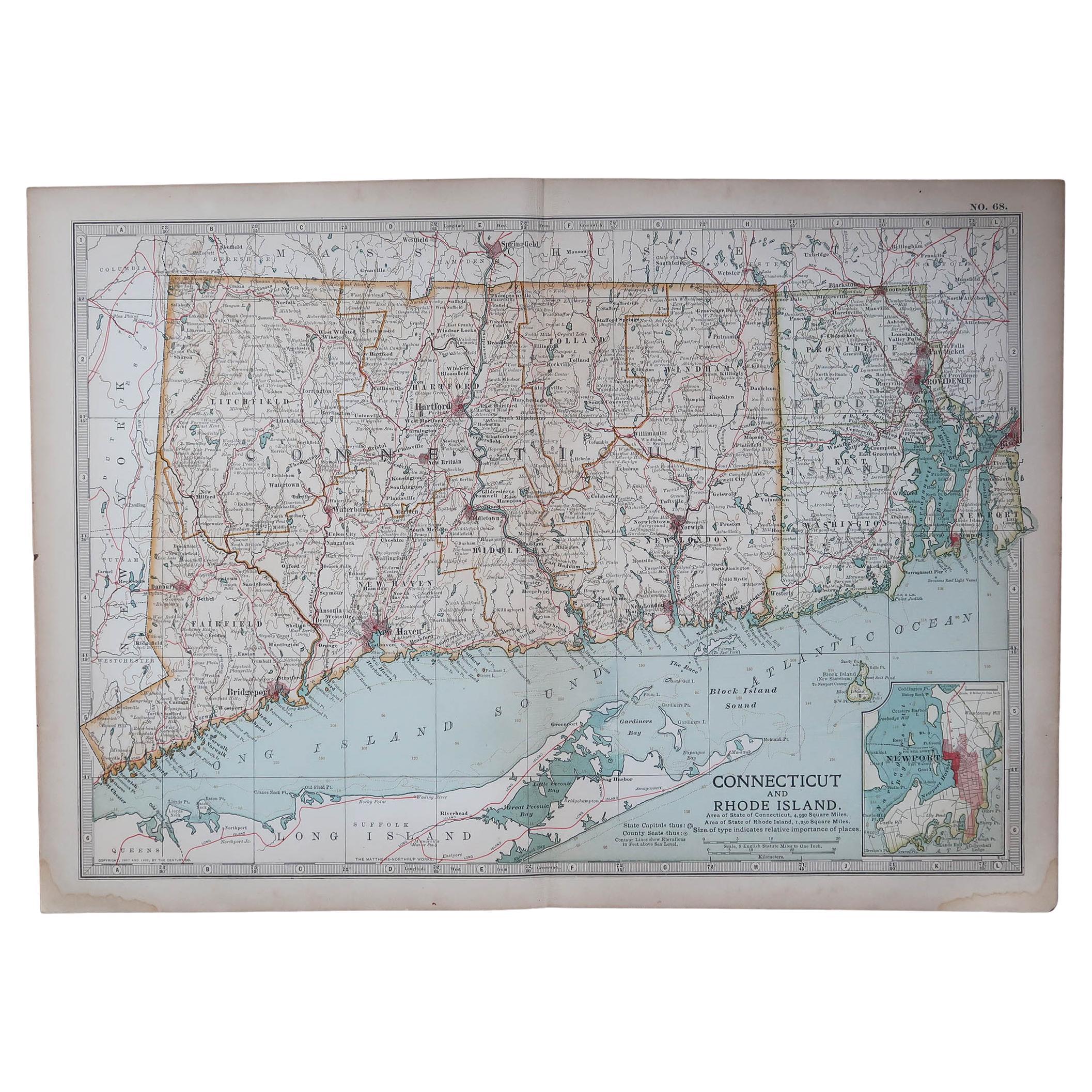
Mappa antica originale dello Stato americano del Connecticut e del Rhode Island, 1903
Antique map of Connecticut and Rhode Island
Published By A & C Black. 1903
Original colour
Good condition
Unframed.
Free shipping
Categoria
Di antiquariato/d’epoca, Inizio Novecento, Inglese, Mappe
Materiali
Carta

49 USD
Spedizione gratuita
Mappa antica originale dello Stato americano del Minnesota, 1903
Mappa antica del Minnesota
Pubblicato da A.I.C. Black. 1903
Colore originale
Buono stato
Senza cornice.
Spedizione gratuita
Categoria
Di antiquariato/d’epoca, Inizio Novecento, Inglese, Mappe
Materiali
Carta

Mappa antica originale dello Stato americano dell'Alabama, 1903
Antique map of Alabama
Published By A & C Black. 1903
Original colour
Good condition
Unframed.
Free shipping
Categoria
Di antiquariato/d’epoca, Inizio Novecento, Inglese, Mappe
Materiali
Carta

Mappa antica originale dello Stato americano dell'Alaska, 1903
Mappa antica dell'Alaska
Pubblicato da A.I.C. Black. 1903
Colore originale
Buono stato
Senza cornice.
Spedizione gratuita
Categoria
Di antiquariato/d’epoca, Inizio Novecento, Inglese, Mappe
Materiali
Carta

Mappa antica originale dello Stato americano del Nebraska, 1903
Mappa antica del Nebraska
Pubblicato da A.I.C. Black. 1903
Colore originale
Buono stato
Senza cornice.
Spedizione gratuita
Categoria
Di antiquariato/d’epoca, Inizio Novecento, Inglese, Mappe
Materiali
Carta

Mappa antica originale dello Stato americano di Washington, 1903
Mappa antica di Washington
Pubblicato da A.I.C. Black. 1903
Colore originale
Buono stato
Senza cornice.
Spedizione gratuita
Categoria
Di antiquariato/d’epoca, Inizio Novecento, Inglese, Mappe
Materiali
Carta
