Articoli simili a Map of United States Central Sheet 1903 – Railroads, States, and Topography


Vuoi altre immagini o video?
Richiedi altre immagini o video al venditore
1 di 10
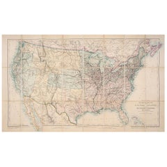
Map of United States Central Sheet 1903 – Railroads, States, and Topography
Informazioni sull’articolo
Map of United States Central Sheet 1903 – Railroads, States, and Topography
This is a finely engraved and beautifully colored map titled "United States of North America (Central Sheet)," created by Keith Johnston and printed by W. & A.K. Johnston, Ltd., in London and Edinburgh. This antique map, dating to the early 20th century, showcases the heartland of the United States in meticulous detail, spanning from the Gulf of Mexico up through the Great Lakes region.
The map covers the states of Texas, Oklahoma, Kansas, Nebraska, the Dakotas, Minnesota, Wisconsin, Iowa, Missouri, and Illinois, with surrounding areas of Colorado, Wyoming, Michigan, Arkansas, and Louisiana. Key features include railroad networks that highlight the rapid industrial expansion of the time, major rivers and mountain ranges, county boundaries, and settlements. The shading and contouring beautifully depict the topography, while delicate hand-coloring demarcates state boundaries with elegant clarity.
Inset with a detailed scale and a small table of mileages, the map is a testament to both the artistry and precision of historical cartography. The typography is crisp and classic, conveying both geographical and cultural importance for historians, map enthusiasts, and collectors.
Condition is very good for its age, with only minimal signs of wear and slight toning around the edges, consistent with gentle handling over the decades. The colors remain vibrant, enhancing the visual appeal of this historical piece.
For framing, consider a traditional dark wood frame to complement the antique style, or a simple black frame to modernize the look while preserving the map’s elegance. A neutral cream or off-white mat would highlight the engraved details and colors. This map would make a wonderful display for a home library, study, or any setting that celebrates American history.
- Dimensioni:Altezza: 47 cm (18,51 in)Larghezza: 36,8 cm (14,49 in)Profondità: 0,2 mm (0,01 in)
- Materiali e tecniche:
- Periodo:
- Data di produzione:1903
- Condizioni:Condition is very good for its age, with only minimal signs of wear and slight toning around the edges, consistent with gentle handling over the decades. The colors remain vibrant, enhancing the visual appeal of this historical piece.
- Località del venditore:Langweer, NL
- Numero di riferimento:Venditore: BG-13577-471stDibs: LU3054345291852
Informazioni sul venditore
5,0
Venditore riconosciuto
Questi venditori prestigiosi sono leader del settore e rappresentano il massimo in termini di qualità e design.
Venditore Oro
Venditori Premium con valutazione 4,3+ e tempi di risposta entro 24 ore
Fondazione nel 2009
Venditore 1stDibs dal 2017
2.462 vendite su 1stDibs
Tempo di risposta standard: <1 ora
- SpedizioneRecupero del preventivo…Spedizione da: Langweer, Paesi Bassi
- Politica di reso
Alcune parti di questa pagina sono state tradotte automaticamente. 1stDibs non può garantire che le traduzioni siano corrette. L’inglese è la lingua predefinita del sito.
Garanzia di autenticità
Nell’improbabile caso in cui si verifichi un problema con l’autenticità di un articolo, contattaci entro un anno per ottenere un rimborso completo. DettagliGaranzia di rimborso
Se il tuo articolo non corrisponde alla descrizione, è danneggiato durante il trasporto o non arriva, contattaci entro 7 giorni per un rimborso completo. DettagliAnnullamento entro 24 ore
Hai un periodo di tolleranza di 24 ore per annullare il tuo acquisto, senza necessità di fornire spiegazioni.Venditori professionali selezionati
I nostri venditori di livello internazionale devono aderire a rigorosi standard di servizio e qualità, garantendo l’integrità delle inserzioni.Garanzia miglior prezzo
Se scopri che un venditore ha pubblicato altrove lo stesso articolo a un prezzo più basso, applicheremo lo stesso prezzo.Consegna globale affidabile
La nostra rete di vettori leader del settore offre opzioni di spedizione specializzate in tutto il mondo, inclusa la consegna personalizzata.Altro da questo venditore
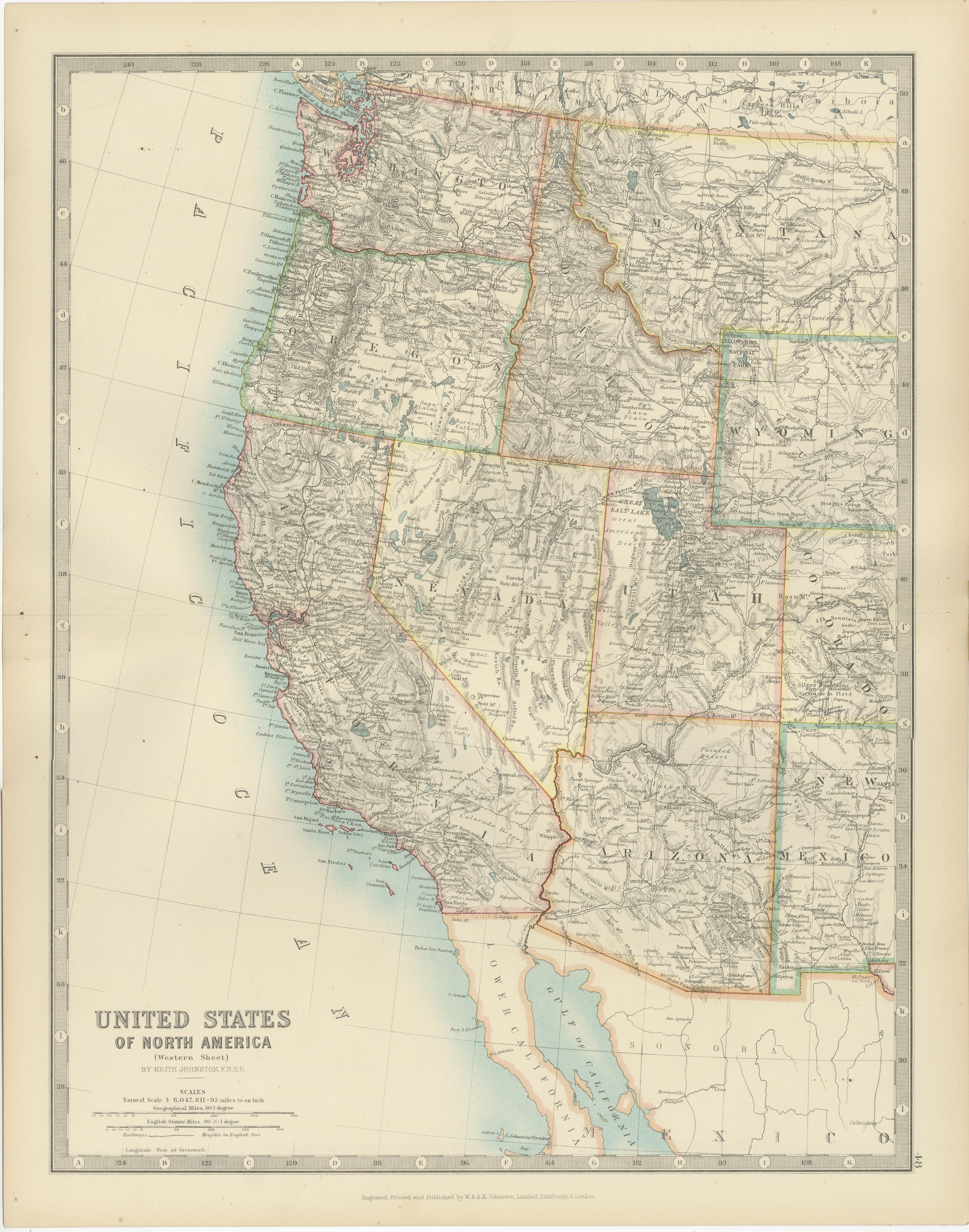
Mostra tuttoMap of Western United States 1903 – Railroads, State Borders, and Terrain
Map of Western United States 1903 – Railroads, State Borders, and Terrain
This beautifully engraved map titled "United States of North America (Western Sheet)" was created by Keith ...
Categoria
Inizio XX secolo, Mappe
Materiali
Carta

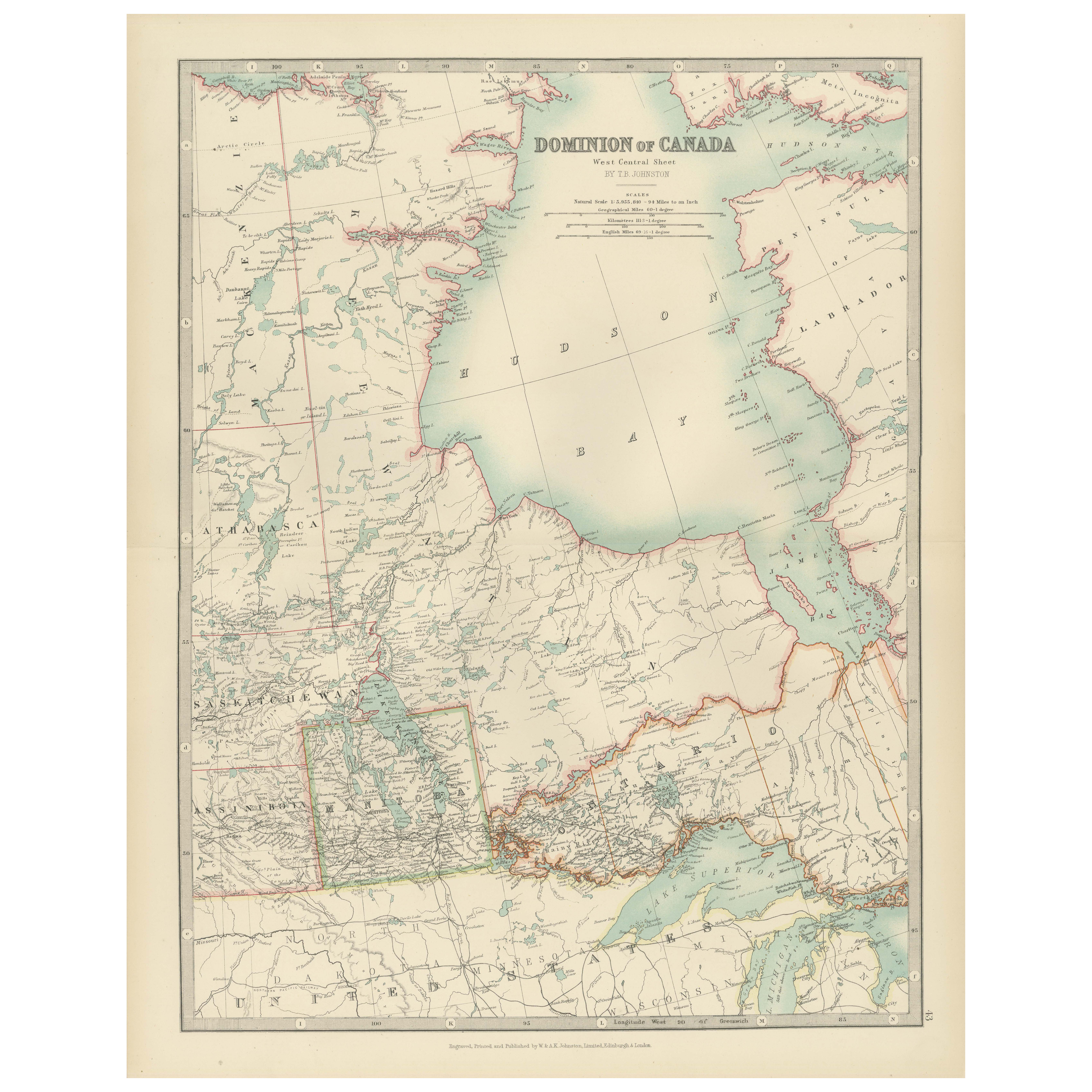
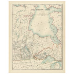
Canada Map 1903 - Dominion of Canada, West Central Sheet
Title: Canada Map 1903 - Dominion of Canada, West Central Sheet
Description:
This fascinating 1903 map of the Dominion of Canada’s West Central regions by T.R. Johnston offers a viv...
Categoria
Inizio XX secolo, Mappe
Materiali
Carta
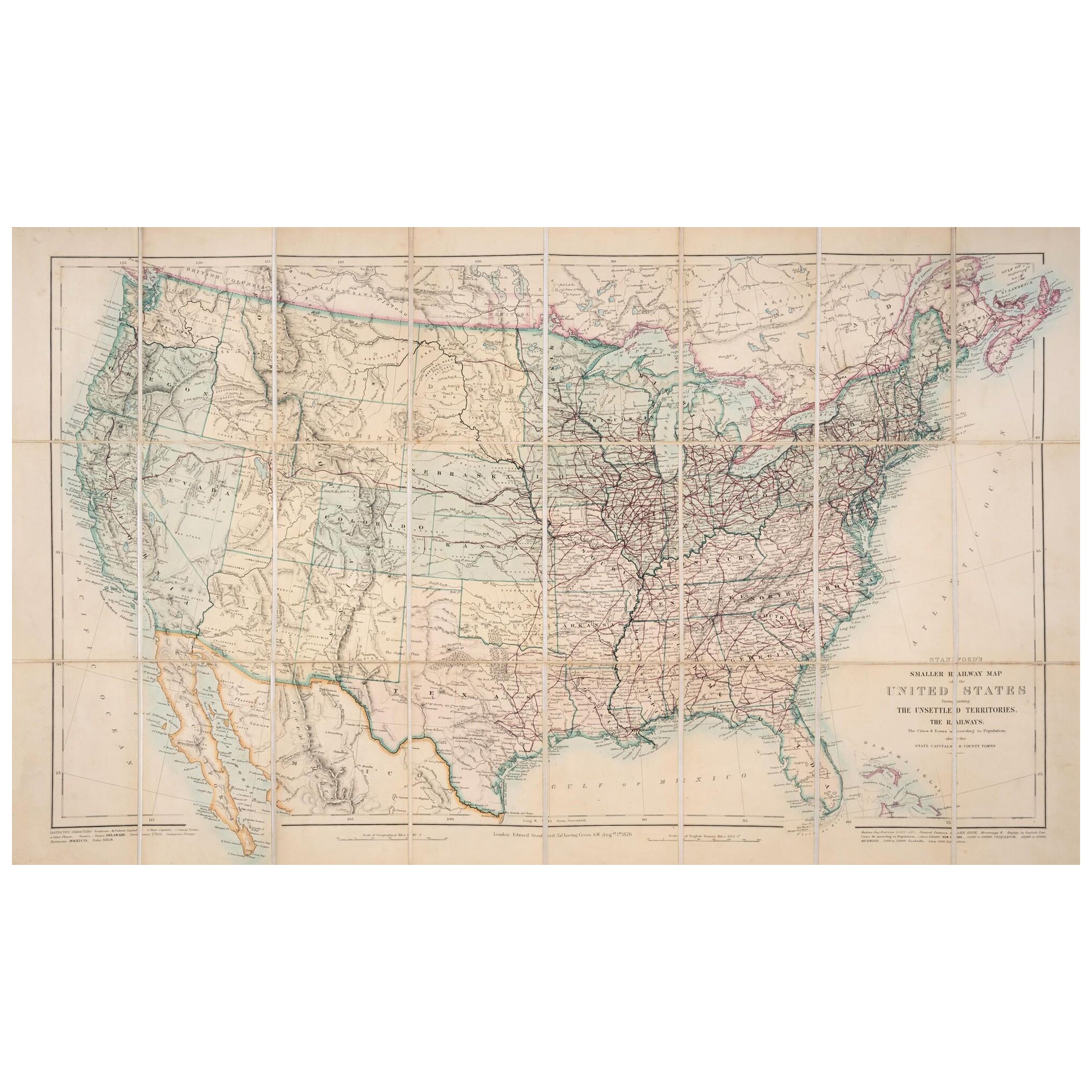
Mappa degli Stati Uniti del 1876: Con i dettagli delle ferrovie e dei territori non colonizzati
Mappa ferroviaria ridotta degli Stati Uniti di Stanford, 1876
Questa mappa originale del 1876, intitolata "Stanford's Smaller Railway Map of the United States Distinguishing the Uns...
Categoria
Di antiquariato/d’epoca, Anni 1870, Mappe
Materiali
Carta
Carta ferroviaria antica degli Stati Uniti di Rand, McNally & Co., 1900
Carta geografica antica intitolata "Rand, McNally & Co. New Official Railroad map of the United States with portions of The Dominion of Canada, The Republic of Mexico and the West In...
Categoria
XX secolo, Mappe
Materiali
Lino, Carta

2.180 USD Prezzo promozionale
25% in meno
Spedizione gratuita
Piccola mappa degli Stati Uniti
Carta geografica antica intitolata 'Amérique septe. Fisico". Piccola mappa degli Stati Uniti. litografata dai fratelli C. Callewaert a Bruxelles nel 1870 circa.
Categoria
Di antiquariato/d’epoca, Metà XIX secolo, Mappe
Materiali
Carta

69 USD Prezzo promozionale
20% in meno
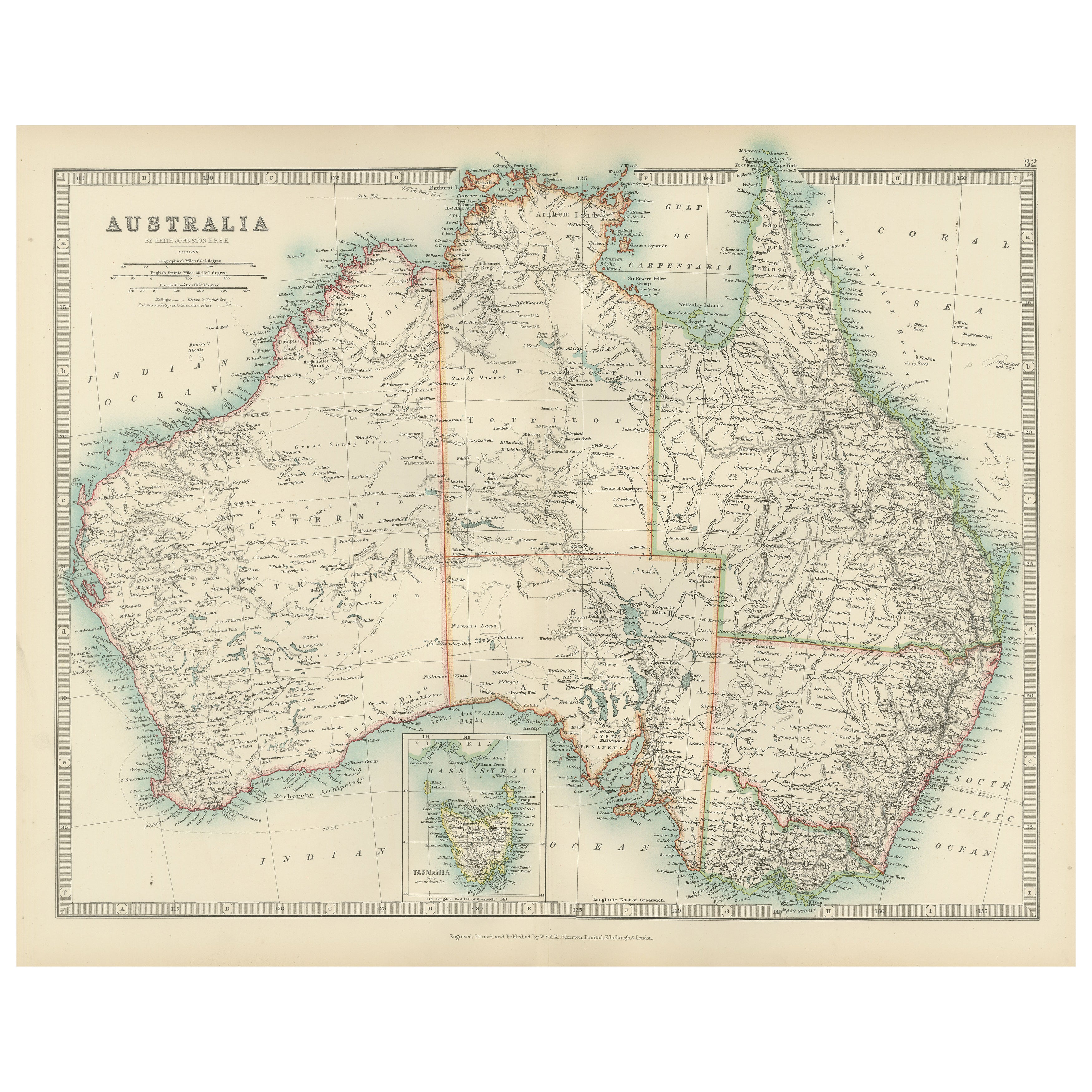
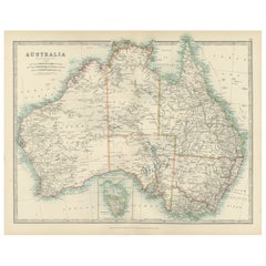
Antique Map of Australia, 1903, with Colonial Divisions and Detailed Topography
Title: Antique Map of Australia, 1903, with Colonial Divisions and Detailed Topography
Description: This antique map, titled "Australia," was engraved and published in 1903 by W. & ...
Categoria
Inizio XX secolo, Mappe
Materiali
Carta
Ti potrebbe interessare anche
Mappa degli Stati Uniti con cornice vintage
Mappa degli Stati Uniti in carta invecchiata d'epoca montata su pannello di particelle e incorniciata in una semplice cornice di legno.
Categoria
XX secolo, Americano, Mid-Century moderno, Mappe
Materiali
Legno, Carta

Mappa del Messico e degli Stati Uniti del 1830 con cornice
Mappa del Nord America pubblicata nel 1830 circa. La mappa mostra gli Stati Uniti e il Canada. Messico che si estende nel territorio dell'alta California. Il Texas compare nel nome m...
Categoria
Di antiquariato/d’epoca, Anni 1830, Americano, Classico americano, Mappe
Materiali
Vetro, Legno, Carta

Mappa antica originale degli Stati Uniti, Grattan and Gilbert, 1843
Grande mappa degli Stati Uniti
Disegnato e inciso da Archer
Pubblicato da Grattan e Gilbert. 1843
Colore originale
Senza cornice.
Categoria
Di antiquariato/d’epoca, Anni 1840, Inglese, Mappe
Materiali
Carta

Mappa degli Stati Uniti incorniciata e colorata a mano del 1820
Foto con cornice di mappe colorate a mano del 1820 del Nord America e del Sud America. Come trovato incorniciato in una cornice di legno dorato.
Categoria
Di antiquariato/d’epoca, Anni 1820, Americano, Coloniale spagnolo, Mappe
Materiali
Legno dorato, Carta, Vetro

Mappa degli Stati Uniti incorniciata e colorata a mano del 1839
Mappa degli Stati Uniti d'America incorniciata e colorata a mano del 1839. Incorniciato di recente in una cornice di legno dorato.
Categoria
Di antiquariato/d’epoca, Anni 1830, Americano, Classico americano, Mappe
Materiali
Legno dorato, Carta, Vetro

1859 "Mappa degli Stati Uniti d'America..." di J.H. Colton
Di J.H. Colton
Viene presentata una "Mappa degli Stati Uniti d'America, delle Province Britanniche, del Messico, delle Indie Occidentali e dell'America Centrale con parte della Nuova Granada e del ...
Categoria
Di antiquariato/d’epoca, Anni 1850, Americano, Mappe
Materiali
Carta
