Articoli simili a Botanical Map by A.K. Johnston – Global Plant Distribution Chart 1852


Vuoi altre immagini o video?
Richiedi altre immagini o video al venditore
1 di 10
Botanical Map by A.K. Johnston – Global Plant Distribution Chart 1852
260 €per articolo|IVA inclusa
Quantità
Informazioni sull’articolo
Botanical Map by A.K. Johnston – Global Plant Distribution Chart 1852
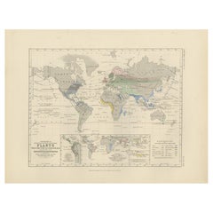
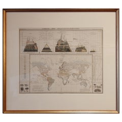
This remarkable antique chart titled "The Distribution of the Most Important Trees, Shrubs, Grains, & Fruits According to Zones of Climate & Moisture" was created by Alexander Keith Johnston and published in 1852 by William Blackwood & Sons, Edinburgh and London. It is Plate 15 from Johnston’s revolutionary *Physical Atlas of Natural Phenomena*, a foundational work in scientific cartography.
This thematic map combines botanical geography and climatology to illustrate how vegetation and agricultural crops are distributed across the globe according to climatic zones and moisture levels. Zones such as the "Climate of the Tropics," "European & Tropical," and "Northern Zone of Perpetual Ice and Snow" are color-coded and labeled with the dominant plants, fruits, or grains associated with each area.
The map meticulously annotates where particular species grow best: bananas and sugarcane in equatorial regions, wheat and apples in temperate zones, palms and spice trees in the tropics, and mosses and berries in the Arctic. The influence of rainfall and elevation is also emphasized, providing a multidimensional understanding of global botanical ecology as understood in the 19th century.
Beneath the main map is a stunning cross-sectional diagram titled "Distribution of Plants in a Vertical Direction," illustrating mountain ecosystems from the Rocky Mountains and Andes to the Himalayas and Alps. As the elevation rises, the vegetation zones change—from tropical palms at the base to alpine mosses and lichens near the peaks—offering a visual summary of how altitude affects plant distribution as dramatically as latitude.
Alexander Keith Johnston (1804–1871), a leading figure in Victorian science and cartography, was Geographer in Ordinary to Queen Victoria in Scotland. His work revolutionized the use of maps to present scientific data, and his *Physical Atlas* is still admired for its clarity, elegance, and educational ambition.
This chart is a must-have for collectors of botanical history, early climatology, or decorative scientific illustrations. Its blend of empirical data and visual storytelling is both informative and visually compelling.
Condition and framing tips:
Very good antique condition with minor age toning and a clean printed surface. A striking plate for display, best framed in walnut or gold with a warm ivory mat to highlight the earthy tones and detailed illustrations. Ideal for a library, conservatory, or academic interior.
- Dimensioni:Altezza: 27,4 cm (10,79 in)Larghezza: 34,5 cm (13,59 in)Profondità: 0,2 mm (0,01 in)
- Materiali e tecniche:
- Luogo di origine:
- Periodo:
- Data di produzione:1852
- Condizioni:Very good condition. Light overall toning near the margins. The paper remains strong and well-preserved. Folding line as issued.
- Località del venditore:Langweer, NL
- Numero di riferimento:Venditore: BG-13207-151stDibs: LU3054345393502
Informazioni sul venditore
5,0
Venditore riconosciuto
Questi venditori prestigiosi sono leader del settore e rappresentano il massimo in termini di qualità e design.
Venditore Platino
Venditori Premium con valutazione 4.7+ e tempi di risposta entro 24 ore
Fondazione nel 2009
Venditore 1stDibs dal 2017
2641 vendite su 1stDibs
Tempo di risposta standard: <1 ora
- SpedizioneRecupero del preventivo…Spedizione da: Langweer, Paesi Bassi
- Politica di reso
Alcune parti di questa pagina sono state tradotte automaticamente. 1stDibs non può garantire che le traduzioni siano corrette. L’inglese è la lingua predefinita del sito.
Garanzia di autenticità
Nell’improbabile caso in cui si verifichi un problema con l’autenticità di un articolo, contattaci entro un anno per ottenere un rimborso completo. DettagliGaranzia di rimborso
Se il tuo articolo non corrisponde alla descrizione, è danneggiato durante il trasporto o non arriva, contattaci entro 7 giorni per un rimborso completo. DettagliAnnullamento entro 24 ore
Hai un periodo di tolleranza di 24 ore per annullare il tuo acquisto, senza necessità di fornire spiegazioni.Venditori professionali selezionati
I nostri venditori di livello internazionale devono aderire a rigorosi standard di servizio e qualità, garantendo l’integrità delle inserzioni.Garanzia miglior prezzo
Se scopri che un venditore ha pubblicato altrove lo stesso articolo a un prezzo più basso, applicheremo lo stesso prezzo.Consegna globale affidabile
La nostra rete di vettori leader del settore offre opzioni di spedizione specializzate in tutto il mondo, inclusa la consegna personalizzata.Altro da questo venditore
Mostra tuttoMappa antica che mostra la distribuzione delle piante di Johnston, 1850
Mappa antica intitolata "Distribuzione geografica delle piante". Mappa antica originale che mostra la distribuzione delle piante. Questa mappa proviene da 'The Physical Atlas of Natu...
Categoria
Di antiquariato/d’epoca, Metà XIX secolo, Mappe
Materiali
Carta

160 € Prezzo promozionale
20% in meno
Mappa antica del mondo che mostra la distribuzione di piante e minerali, 1872
Carta geografica antica intitolata "Il mondo di Johnson che mostra la distribuzione degli alberi forestali caratteristici (...)". Mappa del mondo originale che mostra la distribuzion...
Categoria
Di antiquariato/d’epoca, Fine XIX secolo, Mappe
Materiali
Carta

160 € Prezzo promozionale
20% in meno
Mappa antica della distribuzione delle piante di Johnston del 1850
Mappa antica intitolata "Piante geografiche utilizzate come cibo per l'uomo". Mappa antica originale che mostra la distribuzione delle piante. Questa mappa proviene da 'The Physical ...
Categoria
Di antiquariato/d’epoca, Metà XIX secolo, Mappe
Materiali
Carta
160 € Prezzo promozionale
20% in meno
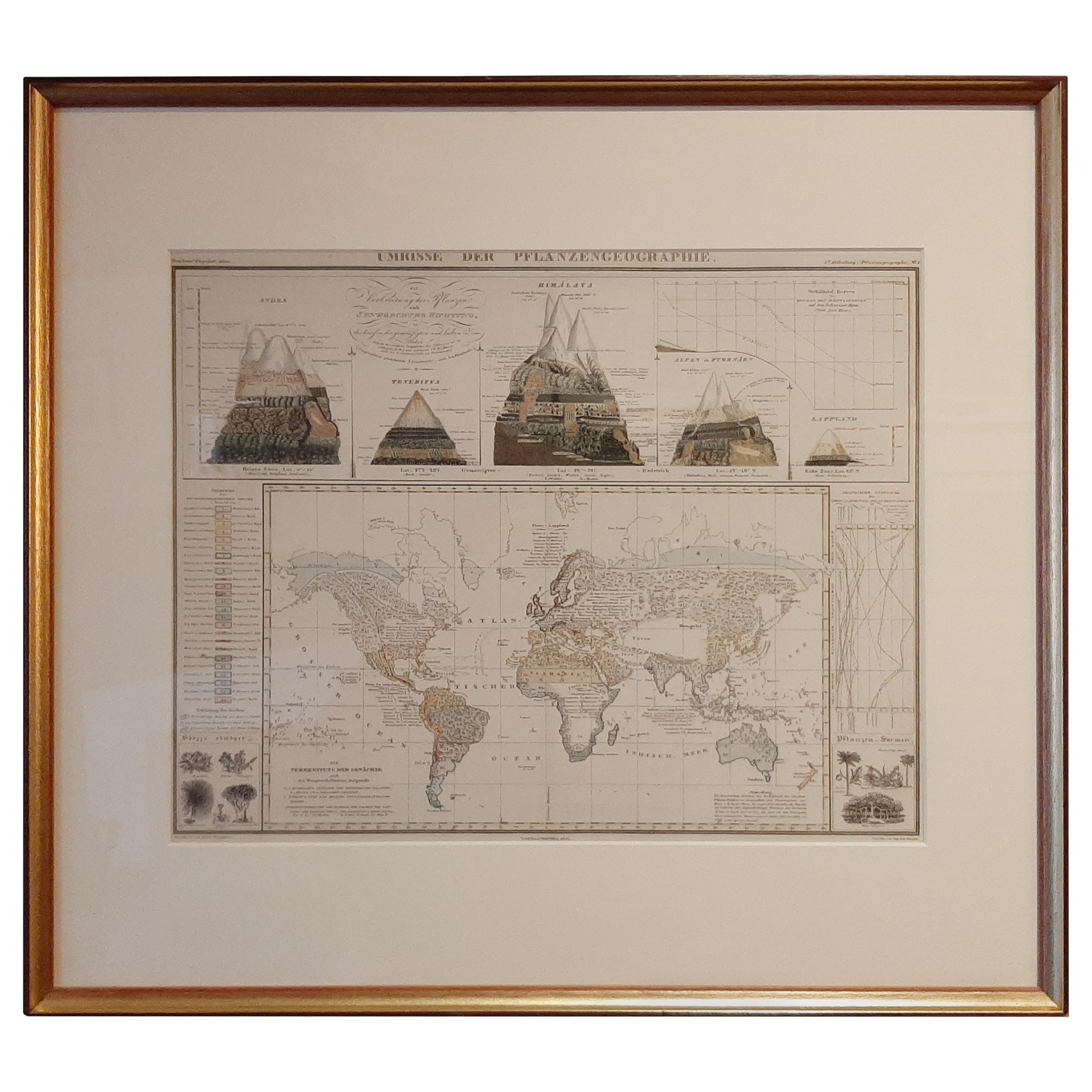
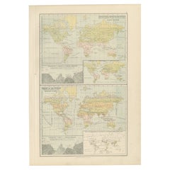
Carta antica della distribuzione della vegetazione nel mondo "1851
Carta geografica antica intitolata "Umrisse der Pflanzengeographie". Mappa antica originale che mostra la distribuzione della vegetazione in tutto il mondo. Cinque disegni sopra la m...
Categoria
Di antiquariato/d’epoca, Metà XIX secolo, Mappe
Materiali
Carta
600 € Prezzo promozionale
20% in meno
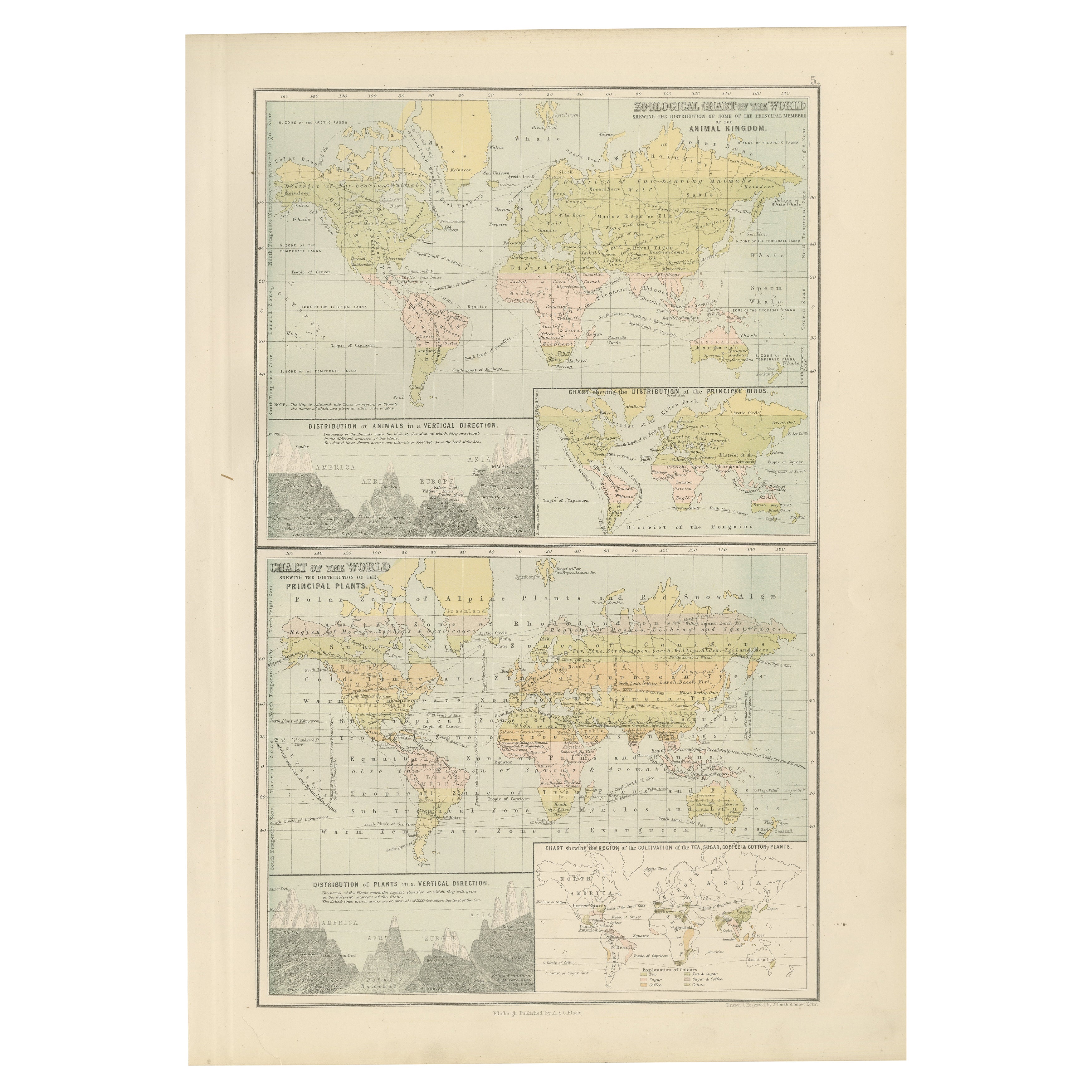
Antica carta zoologica e botanica del mondo - Mappa decorativa, 1884
Antiche carte zoologiche e botaniche del mondo - Atlante di Black, 1884
Questa doppia lastra tratta dalla New and Revised Edition of Black's General Atlas of the World, pubblicata a...
Categoria
Di antiquariato/d’epoca, Anni 1880, Scozzese, Mappe
Materiali
Carta
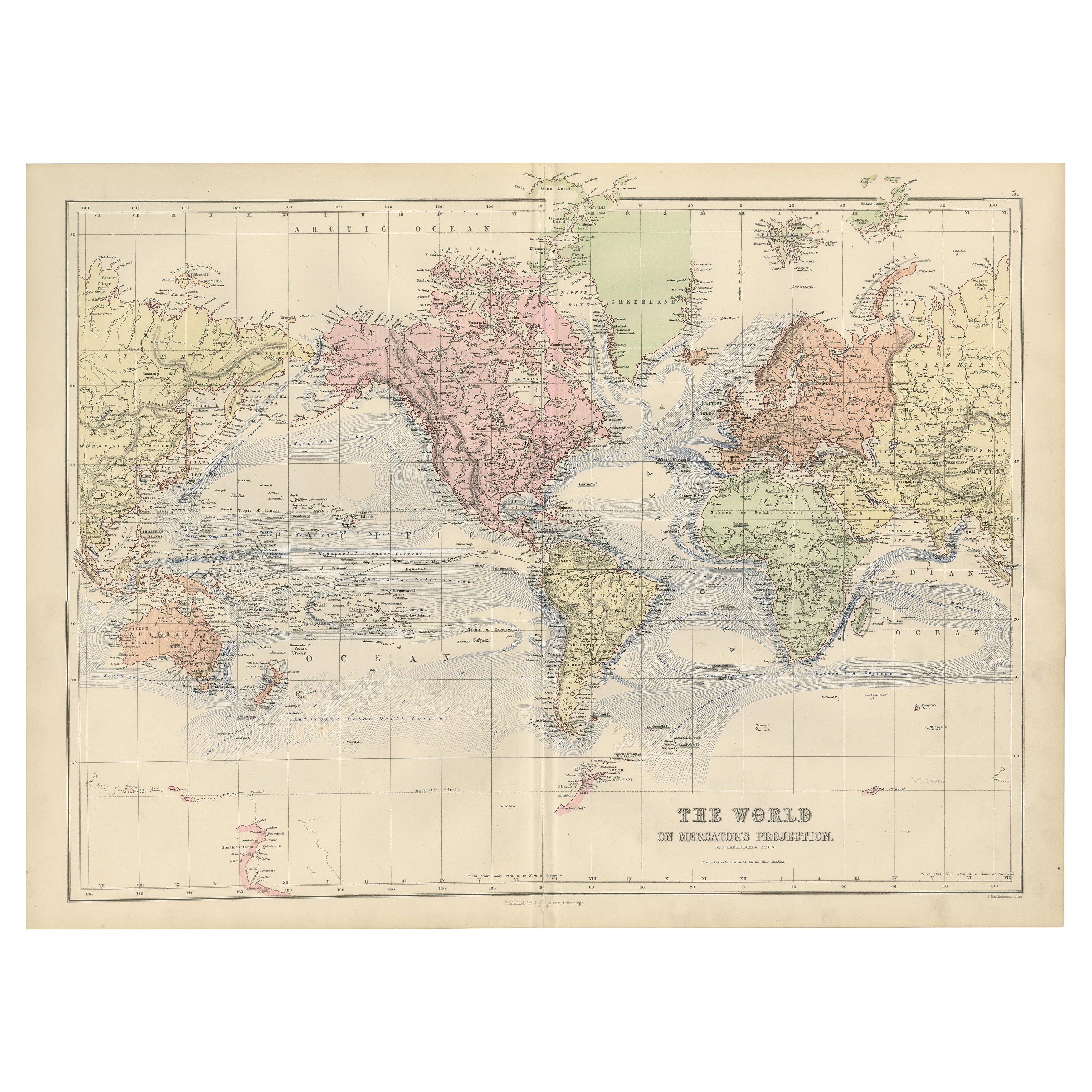
Mappa del mondo decorativa del 1884 - Proiezione di Mercatore, stampa dell'epoca vittoriana
Carta del mondo antica con proiezione di Mercatore - Atlante di Black, 1884
Questa mappa finemente incisa e colorata, intitolata The World on Mercator's Projection, è stata pubblica...
Categoria
Di antiquariato/d’epoca, Anni 1880, Scozzese, Mappe
Materiali
Carta

Ti potrebbe interessare anche
Mappa antica originale del mondo di Dower, 1835 circa
Bella mappa del mondo
Disegnato e inciso da J.Dower
Pubblicato da Orr & Smith. C.1835
Senza cornice.
Spedizione gratuita
Categoria
Di antiquariato/d’epoca, Anni 1830, Inglese, Mappe
Materiali
Carta

1864 Planisfero originale illustrato - Mappa del mondo - Geografia
Immergiti nell'epico viaggio del passato con il Planisfero Storico Illustrato del 1864 di Charpentier! 🗺️ Questo tesoro cartografico ti trasporta attraverso le complessità della sto...
Categoria
Anni 1860, Stampe e riproduzioni
Materiali
Lino, Litografia, Carta

Mappa antica originale del mondo di Thomas Clerk, 1817
Grande mappa dell'emisfero orientale e occidentale
Su 2 fogli
Incisione su rame
Disegnato e inciso da Thomas Clerk, Edimburgo.
Pubblicato da Mackenzie And Dent, 1817
N...
Categoria
Di antiquariato/d’epoca, Anni 1810, Inglese, Mappe
Materiali
Carta

Mappa antica originale dell'emisfero occidentale di Dower, 1835 circa
Bella mappa dell'emisfero occidentale
Disegnato e inciso da J.Dower
Pubblicato da Orr & Smith. C.1835
Senza cornice.
Spedizione gratuita
Categoria
Di antiquariato/d’epoca, Anni 1830, Inglese, Mappe
Materiali
Carta

Grande mappa antica originale del mondo, Fullarton, 1870 ca.
Grande mappa del mondo. Mostra entrambi gli emisferi
Dal celebre Atlante Reale Illustrato
Litografia. Colore originale.
Pubblicato da Fullarton, Edimburgo, 1870 ca.
Senza cornic...
Categoria
Di antiquariato/d’epoca, Anni 1870, Scozzese, Mappe
Materiali
Carta

John Thomson (1777-1840) - Incisione su mappa del 1830, Carta del Mondo
Di John Thomson
Una bella mappa del mondo incisa sulla proiezione di Mercatore, tratta dalla seconda edizione del "New General Atlas" di John Thomson pubblicato nel 1830. Sulla carta.
Categoria
Inizio XIX secolo, Altre stampe
Materiali
Incisione
274 € Prezzo promozionale
20% in meno