Articoli simili a Climatological Map by A.K. Johnston – Global Temperatures Chart 1852


Vuoi altre immagini o video?
Richiedi altre immagini o video al venditore
1 di 10
Climatological Map by A.K. Johnston – Global Temperatures Chart 1852
260 €per articolo|IVA inclusa
Quantità
Informazioni sull’articolo
Climatological Map by A.K. Johnston – Global Temperatures Chart 1852
This exceptional antique map titled "Climatological Chart Showing by Lines & Figures the Mean Annual Temperature of the Principal Places on the Globe" was created by Alexander Keith Johnston and published in 1852 by William Blackwood & Sons of Edinburgh and London. It was issued as Plate 12 in Johnston’s landmark *Physical Atlas of Natural Phenomena*, a pioneering 19th-century atlas that brought scientific visualization into wide public use.
This map is an early attempt to systematically present global climate data. It displays mean annual temperatures across the world using isothermal lines (red and blue) that connect locations of equal average temperature. The isotherms are drawn with precise geographic accuracy and overlaid with data from major cities and meteorological stations. The red lines represent mean annual temperatures at various latitudes, while blue lines denote temperature during winter.
The chart also includes two detailed insets. One shows the British Isles with a focus on summer and winter mean temperatures by city and station, while the second presents similar data for Central Europe. These regional maps offer insight into 19th-century meteorological science and the importance of regional climate comparisons in early climatology.
Johnston’s meticulous work combines data with elegant cartographic design. His maps are not only valuable scientific tools but also highly decorative. Johnston (1804–1871), Geographer in Ordinary to Queen Victoria in Scotland, was instrumental in the development of thematic cartography. His *Physical Atlas* remains one of the most influential scientific atlases ever published, appreciated for its beauty and clarity as much as for its content.
This plate is particularly interesting for its foresight in climate science and as an early visual reference to global temperature distribution—concepts that underpin today’s environmental studies and climate models.
Condition and framing tips:
Good condition with light age toning and minor wear at the margins. Image field clean and sharp. Frame in matte black or dark walnut with a cream or ivory mat to highlight the fine engraved lines and soft red and blue temperature curves. Ideal for scholars, educators, and interiors with a natural history or scientific theme.
- Dimensioni:Altezza: 34,5 cm (13,59 in)Larghezza: 27,4 cm (10,79 in)Profondità: 0,2 mm (0,01 in)
- Materiali e tecniche:
- Luogo di origine:
- Periodo:
- Data di produzione:1852
- Condizioni:Very good condition. Light overall toning near the margins. The paper remains strong and well-preserved. Folding line as issued.
- Località del venditore:Langweer, NL
- Numero di riferimento:Venditore: BG-13207-121stDibs: LU3054345393422
Informazioni sul venditore
5,0
Venditore riconosciuto
Questi venditori prestigiosi sono leader del settore e rappresentano il massimo in termini di qualità e design.
Venditore Platino
Venditori Premium con valutazione 4.7+ e tempi di risposta entro 24 ore
Fondazione nel 2009
Venditore 1stDibs dal 2017
2641 vendite su 1stDibs
Tempo di risposta standard: <1 ora
- SpedizioneRecupero del preventivo…Spedizione da: Langweer, Paesi Bassi
- Politica di reso
Alcune parti di questa pagina sono state tradotte automaticamente. 1stDibs non può garantire che le traduzioni siano corrette. L’inglese è la lingua predefinita del sito.
Garanzia di autenticità
Nell’improbabile caso in cui si verifichi un problema con l’autenticità di un articolo, contattaci entro un anno per ottenere un rimborso completo. DettagliGaranzia di rimborso
Se il tuo articolo non corrisponde alla descrizione, è danneggiato durante il trasporto o non arriva, contattaci entro 7 giorni per un rimborso completo. DettagliAnnullamento entro 24 ore
Hai un periodo di tolleranza di 24 ore per annullare il tuo acquisto, senza necessità di fornire spiegazioni.Venditori professionali selezionati
I nostri venditori di livello internazionale devono aderire a rigorosi standard di servizio e qualità, garantendo l’integrità delle inserzioni.Garanzia miglior prezzo
Se scopri che un venditore ha pubblicato altrove lo stesso articolo a un prezzo più basso, applicheremo lo stesso prezzo.Consegna globale affidabile
La nostra rete di vettori leader del settore offre opzioni di spedizione specializzate in tutto il mondo, inclusa la consegna personalizzata.Altro da questo venditore
Mostra tuttoWind and Hurricane Map by A.K. Johnston – Meteorological Chart 1852
Wind and Hurricane Map by A.K. Johnston – Meteorological Chart 1852
This scientifically significant 1852 map titled "The Distribution of the Constant, Periodical & Variable Winds Ov...
Categoria
Di antiquariato/d’epoca, Metà XIX secolo, Scozzese, Stampe
Materiali
Carta

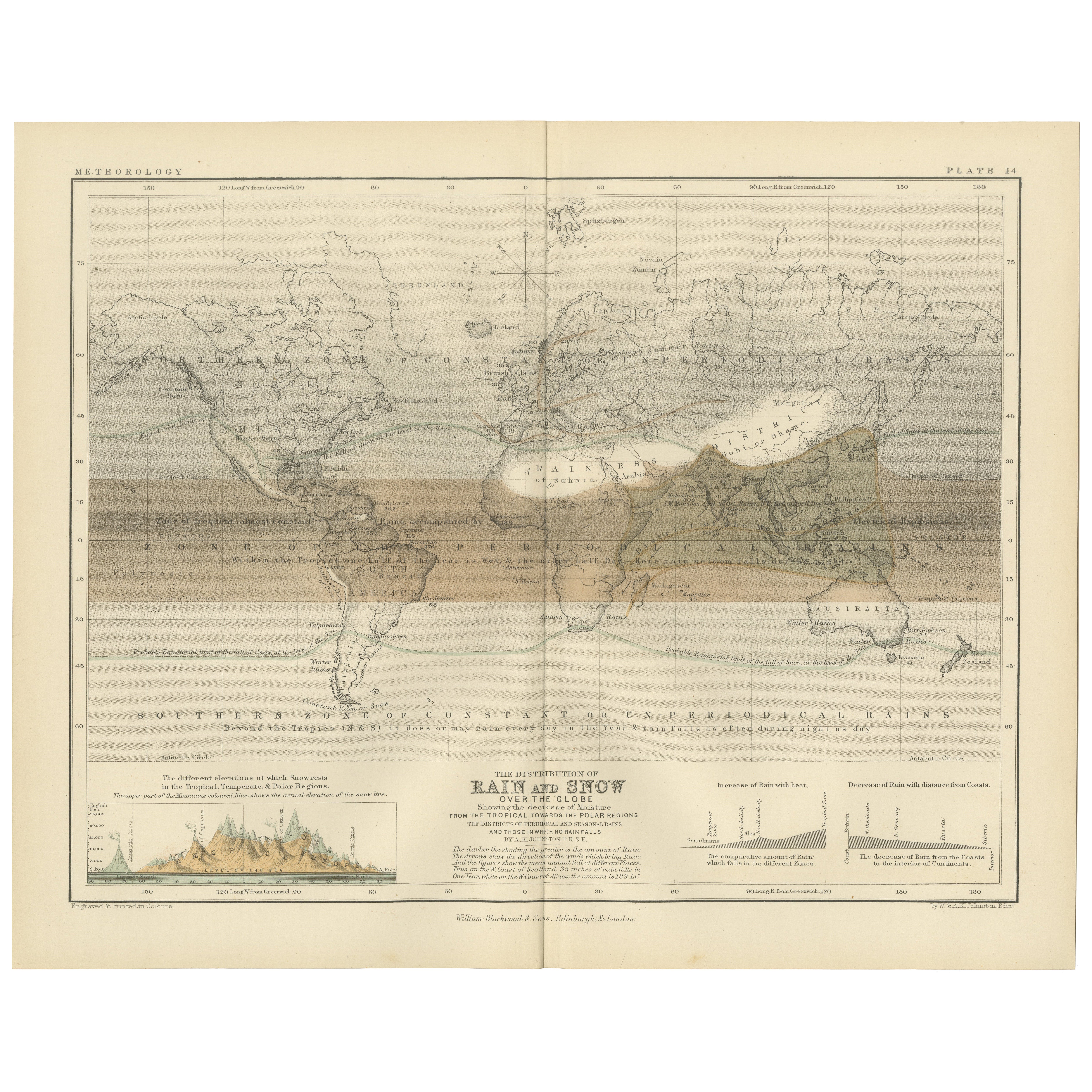
Rain and Snow Map by A.K. Johnston – Global Precipitation Chart 1852
Rain and Snow Map by A.K. Johnston – Global Precipitation Chart 1852
This antique meteorological chart titled "The Distribution of Rain and Snow over the Globe" was created by Alexa...
Categoria
Di antiquariato/d’epoca, Metà XIX secolo, Scozzese, Stampe
Materiali
Carta
Mappa antica che mostra le linee isotermiche in tutto il mondo di Johnston del 1850
Mappa antica intitolata "Sistema di linee isotermiche di Humboldt". Mappa antica originale che mostra le linee isoterme in tutto il mondo. Questa mappa proviene da 'The Physical Atla...
Categoria
Di antiquariato/d’epoca, Metà XIX secolo, Mappe
Materiali
Carta

160 € Prezzo promozionale
20% in meno
Mappa antica del mondo che mostra la distribuzione di piante e minerali, 1872
Carta geografica antica intitolata "Il mondo di Johnson che mostra la distribuzione degli alberi forestali caratteristici (...)". Mappa del mondo originale che mostra la distribuzion...
Categoria
Di antiquariato/d’epoca, Fine XIX secolo, Mappe
Materiali
Carta

160 € Prezzo promozionale
20% in meno
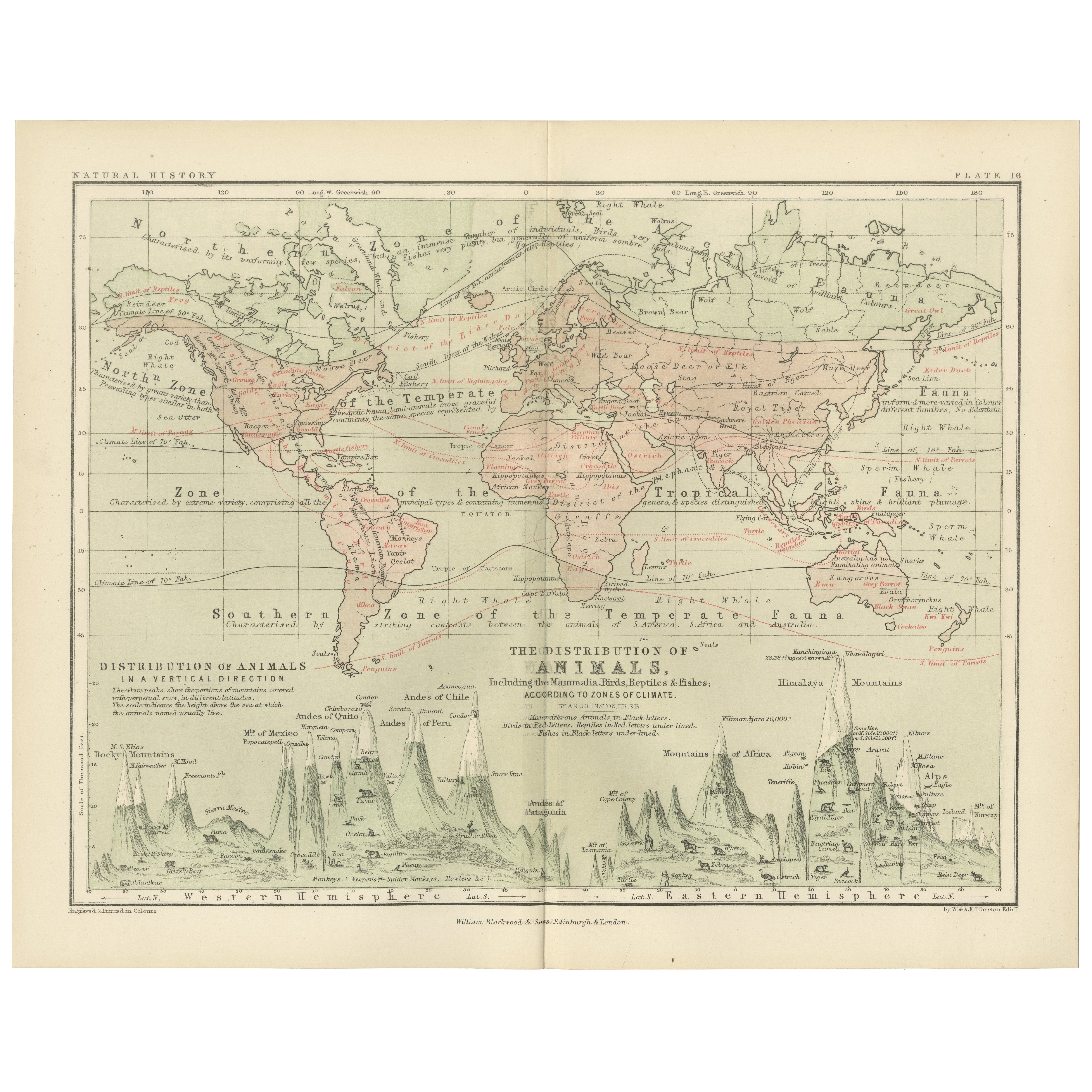
Animal Distribution Map by A.K. Johnston – Fauna by Climate Zones 1852
Animal Distribution Map by A.K. Johnston – Fauna by Climate Zones 1852
This beautifully engraved chart titled "The Distribution of Animals Including the Mammalia, Birds, Reptiles & ...
Categoria
Di antiquariato/d’epoca, Metà XIX secolo, Scozzese, Stampe
Materiali
Carta
Mappa antica che mostra le correnti oceaniche e la temperatura dell'aria, '1872'.
Due mappe su un unico foglio intitolate "Johnson's Oceans Currents (..)" e "Johnson's World showing the Distribution of the Temperature of the Air". Mappa del mondo originale che mos...
Categoria
Di antiquariato/d’epoca, Fine XIX secolo, Mappe
Materiali
Carta

280 € Prezzo promozionale
20% in meno
Ti potrebbe interessare anche
Mappa antica originale del mondo di Thomas Clerk, 1817
Grande mappa dell'emisfero orientale e occidentale
Su 2 fogli
Incisione su rame
Disegnato e inciso da Thomas Clerk, Edimburgo.
Pubblicato da Mackenzie And Dent, 1817
N...
Categoria
Di antiquariato/d’epoca, Anni 1810, Inglese, Mappe
Materiali
Carta

Mappa antica originale dell'emisfero orientale di Dower, 1835 circa
Bella mappa dell'emisfero orientale
Disegnato e inciso da J.Dower
Pubblicato da Orr & Smith. C.1835
Senza cornice.
Spedizione gratuita
Categoria
Di antiquariato/d’epoca, Anni 1830, Inglese, Mappe
Materiali
Carta

Emisfero del Nuovo Continente - Mappa antica di J. J. Heck - 1834.
Di Johann Georg Heck
Emisfero del Nuovo Continente è un'opera d'arte realizzata intorno al 1760 da Johann Georg Heck
Stampa originale a colori.
Buone condizioni, a parte l'ingiallimento della carta e ...
Categoria
Anni 1830, Moderno, Stampe figurative
Materiali
Acquaforte

487 € Prezzo promozionale
25% in meno
Mappa antica originale del mondo di Dower, 1835 circa
Bella mappa del mondo
Disegnato e inciso da J.Dower
Pubblicato da Orr & Smith. C.1835
Senza cornice.
Spedizione gratuita
Categoria
Di antiquariato/d’epoca, Anni 1830, Inglese, Mappe
Materiali
Carta

Mappa antica originale dell'emisfero occidentale di Dower, 1835 circa
Bella mappa dell'emisfero occidentale
Disegnato e inciso da J.Dower
Pubblicato da Orr & Smith. C.1835
Senza cornice.
Spedizione gratuita
Categoria
Di antiquariato/d’epoca, Anni 1830, Inglese, Mappe
Materiali
Carta

Mappa dell'Impero Britannico - Mappa antica di Karl Spruner - 1760 ca.
Di Karl Spruner von Merz
La Mappa dell'Impero Britannico è un'opera d'arte realizzata intorno al 1760 da Karl Spruner.
Stampa originale colorata a mano.
Buone condizioni, a parte l'ingiallimento della cart...
Categoria
Anni 1760, Moderno, Stampe figurative
Materiali
Acquaforte

210 € Prezzo promozionale
25% in meno