Articoli simili a Ethnographic Map of the World by A.K. Johnston – Races of Man Chart 1852


Vuoi altre immagini o video?
Richiedi altre immagini o video al venditore
1 di 10
Ethnographic Map of the World by A.K. Johnston – Races of Man Chart 1852
260 €per articolo|IVA inclusa
Quantità
Informazioni sull’articolo
Ethnographic Map of the World by A.K. Johnston – Races of Man Chart 1852
This antique map titled "Ethnographic Map of the World Showing the Present Distribution of the Leading Races of Man" was created by Alexander Keith Johnston and published in 1852 by William Blackwood & Sons in Edinburgh and London. Issued as Plate 17 in Johnston’s *Physical Atlas of Natural Phenomena*, this map reflects 19th-century efforts to visualize human diversity across the globe through early ethnographic theory.
The map categorizes the world's populations into ten generalized racial and cultural groupings, each represented in distinct pastel shades. These include classifications such as Indo-European, Semitic, Negro, Mongolian, Malay, American, and others based on contemporary (now outdated) 19th-century anthropological thought. The regions of distribution are shaded accordingly, spanning continents from the Arctic Circle to the islands of the Pacific.
A large inset map at the bottom right provides a focused view of Europe, showing greater detail in the distribution of groups such as Slavonic, Germanic, Celtic, Basque, and Finnic peoples. Alongside it is a striking profile diagram illustrating the elevation of Earth's landmasses, tying physical geography to patterns of human settlement.
This map, like many from the mid-19th century, combines the empirical ambitions of early anthropology with the visual clarity of scientific cartography. While its categories and terminology are now considered outdated and oversimplified, the chart is an important artifact from the history of ethnography and reflects the European scientific worldview of the time.
Alexander Keith Johnston (1804–1871), one of the most respected geographers of his age, created the *Physical Atlas* as an educational tool to help readers understand the natural world and its human patterns through maps. His work remains a landmark in the development of thematic cartography.
This plate is a compelling object for collectors of antique maps, anthropology history, or Victorian educational materials, and is often studied for its role in the evolution of ethnographic science.
Condition and framing tips:
Very good condition with minimal age toning and a clean printed surface. Centerfold as issued. Frame in black or dark oak wood with a neutral ivory or parchment mat to complement the subdued palette and historic typography. Suitable for a library, academic office, or collection of early scientific prints.
- Dimensioni:Altezza: 27,4 cm (10,79 in)Larghezza: 34,5 cm (13,59 in)Profondità: 0,2 mm (0,01 in)
- Materiali e tecniche:
- Luogo di origine:
- Periodo:
- Data di produzione:1852
- Condizioni:Very good condition. Light overall toning near the margins and some offset over Europe. The paper remains strong and well-preserved. Folding line as issued.
- Località del venditore:Langweer, NL
- Numero di riferimento:Venditore: BG-13207-171stDibs: LU3054345393552
Informazioni sul venditore
5,0
Venditore riconosciuto
Questi venditori prestigiosi sono leader del settore e rappresentano il massimo in termini di qualità e design.
Venditore Platino
Venditori Premium con valutazione 4.7+ e tempi di risposta entro 24 ore
Fondazione nel 2009
Venditore 1stDibs dal 2017
2641 vendite su 1stDibs
Tempo di risposta standard: <1 ora
- SpedizioneRecupero del preventivo…Spedizione da: Langweer, Paesi Bassi
- Politica di reso
Alcune parti di questa pagina sono state tradotte automaticamente. 1stDibs non può garantire che le traduzioni siano corrette. L’inglese è la lingua predefinita del sito.
Garanzia di autenticità
Nell’improbabile caso in cui si verifichi un problema con l’autenticità di un articolo, contattaci entro un anno per ottenere un rimborso completo. DettagliGaranzia di rimborso
Se il tuo articolo non corrisponde alla descrizione, è danneggiato durante il trasporto o non arriva, contattaci entro 7 giorni per un rimborso completo. DettagliAnnullamento entro 24 ore
Hai un periodo di tolleranza di 24 ore per annullare il tuo acquisto, senza necessità di fornire spiegazioni.Venditori professionali selezionati
I nostri venditori di livello internazionale devono aderire a rigorosi standard di servizio e qualità, garantendo l’integrità delle inserzioni.Garanzia miglior prezzo
Se scopri che un venditore ha pubblicato altrove lo stesso articolo a un prezzo più basso, applicheremo lo stesso prezzo.Consegna globale affidabile
La nostra rete di vettori leader del settore offre opzioni di spedizione specializzate in tutto il mondo, inclusa la consegna personalizzata.Altro da questo venditore
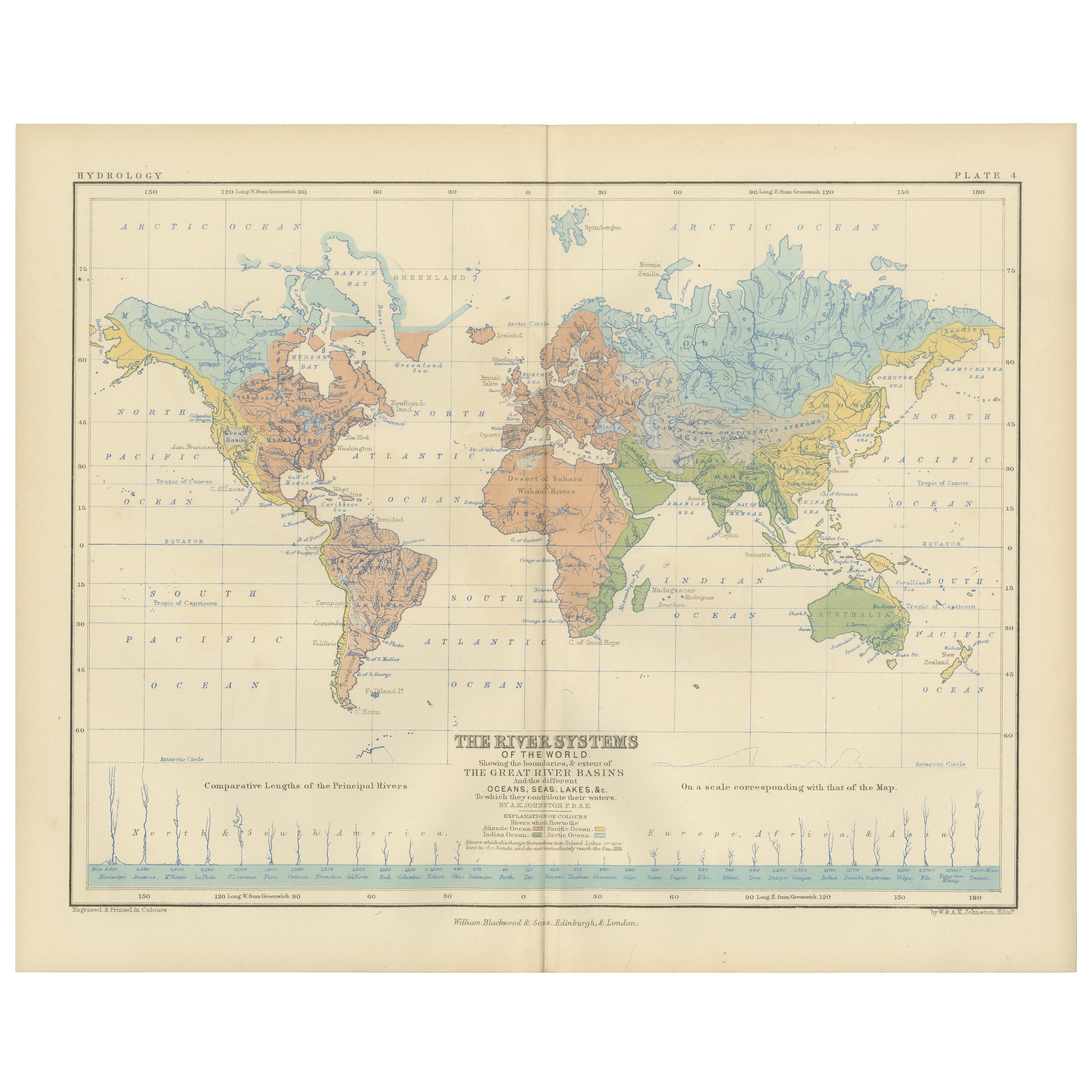
Mostra tuttoRiver Systems Map of the World by A.K. Johnston – Educational Print 1852
River Systems Map of the World by A.K. Johnston – Educational Print 1852
This striking 1852 map titled "The River Systems of the World" was created by the noted Scottish geographer ...
Categoria
Di antiquariato/d’epoca, Metà XIX secolo, Scozzese, Stampe
Materiali
Carta

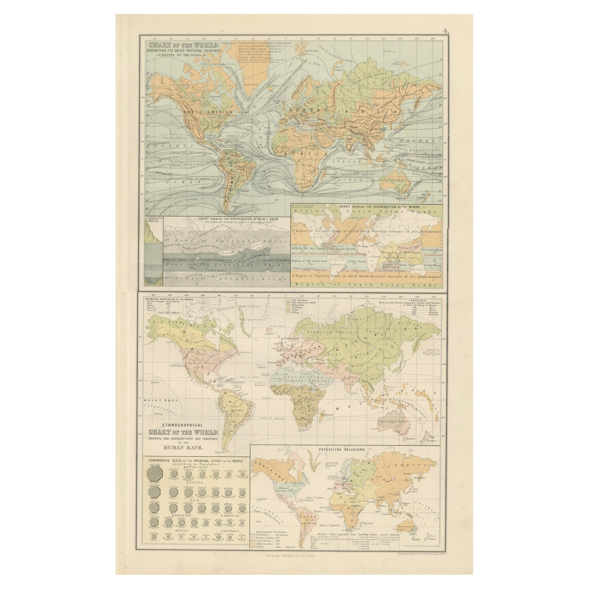
Carta geografica antica del mondo - Caratteristiche fisiche e mappa etnografica, 1884
Carta geografica antica del mondo - Caratteristiche fisiche e mappa etnografica, 1884
Descrizione:
Questa affascinante doppia lastra tratta dalla New and Revised Edition of Black's ...
Categoria
Di antiquariato/d’epoca, Anni 1880, Scozzese, Mappe
Materiali
Carta
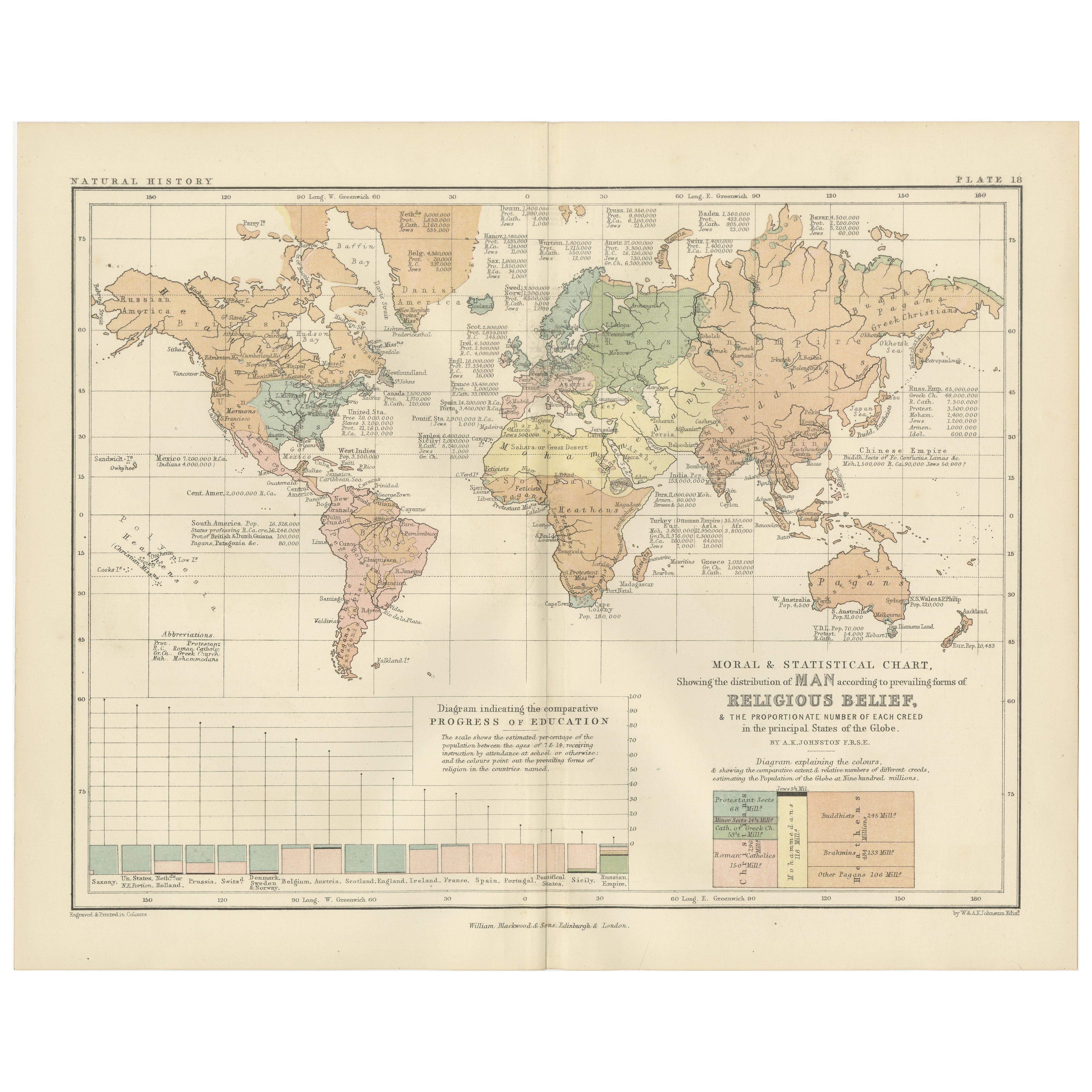
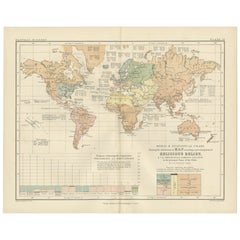
Mappa antica delle religioni nel mondo di Johnston del 1854
Carta geografica antica intitolata "Grafico morale e statistico che mostra la distribuzione geografica dell'uomo secondo le credenze religiose". Rara mappa tematica di grandi dimensi...
Categoria
Di antiquariato/d’epoca, Metà XIX secolo, Mappe
Materiali
Carta

780 € Prezzo promozionale
35% in meno
Religious Belief Map by A.K. Johnston – Moral and Statistical Chart 1852
Religious Belief Map by A.K. Johnston – Moral and Statistical Chart 1852
This antique chart titled "Moral & Statistical Chart Showing the Distribution of Man According to Prevailing...
Categoria
Di antiquariato/d’epoca, Metà XIX secolo, Scozzese, Stampe
Materiali
Carta
Mappa antica del mondo che mostra la distribuzione di piante e minerali, 1872
Carta geografica antica intitolata "Il mondo di Johnson che mostra la distribuzione degli alberi forestali caratteristici (...)". Mappa del mondo originale che mostra la distribuzion...
Categoria
Di antiquariato/d’epoca, Fine XIX secolo, Mappe
Materiali
Carta

160 € Prezzo promozionale
20% in meno
Mappa antica che mostra la divisione e la distribuzione dei mammiferi di Johnston del 1850
Carta geografica antica intitolata "Divisione geografica e distribuzione dei mammiferi degli ordini rodentia e ruminantia nel mondo". Mappa antica originale che mostra la divisione g...
Categoria
Di antiquariato/d’epoca, Metà XIX secolo, Mappe
Materiali
Carta

160 € Prezzo promozionale
20% in meno
Ti potrebbe interessare anche
Mappa antica originale del mondo di Dower, 1835 circa
Bella mappa del mondo
Disegnato e inciso da J.Dower
Pubblicato da Orr & Smith. C.1835
Senza cornice.
Spedizione gratuita
Categoria
Di antiquariato/d’epoca, Anni 1830, Inglese, Mappe
Materiali
Carta

1864 Planisfero originale illustrato - Mappa del mondo - Geografia
Immergiti nell'epico viaggio del passato con il Planisfero Storico Illustrato del 1864 di Charpentier! 🗺️ Questo tesoro cartografico ti trasporta attraverso le complessità della sto...
Categoria
Anni 1860, Stampe e riproduzioni
Materiali
Lino, Litografia, Carta

Mappa dell'Impero Britannico - Mappa antica di Karl Spruner - 1760 ca.
Di Karl Spruner von Merz
La Mappa dell'Impero Britannico è un'opera d'arte realizzata intorno al 1760 da Karl Spruner.
Stampa originale colorata a mano.
Buone condizioni, a parte l'ingiallimento della cart...
Categoria
Anni 1760, Moderno, Stampe figurative
Materiali
Acquaforte

210 € Prezzo promozionale
25% in meno
Mappa del mondo - Acquaforte originale - 1820
La Mappa del Mondo è un'acquaforte originale realizzata da un artista sconosciuto del XIX secolo nel 1820.
Ottimo stato su due fogli di carta bianca uniti al centro.
La mappa è un'...
Categoria
Anni 1820, Moderno, Stampe figurative
Materiali
Acquaforte

Carta geografica antica dell'emisfero orientale dalla collezione di Thierry Despont
Disegnato da Enrico Bonetti (E. Bonatti) e pubblicato da Francesco Vallardi Editore. Basata su una precedente mappa di Evangelista Azzi (Ev. Azzi). Etichettato come tale sul bordo in...
Categoria
Di antiquariato/d’epoca, Fine XIX secolo, Italiano, Mappe
Materiali
Tela, Legno

Mappa antica originale del mondo di Thomas Clerk, 1817
Grande mappa dell'emisfero orientale e occidentale
Su 2 fogli
Incisione su rame
Disegnato e inciso da Thomas Clerk, Edimburgo.
Pubblicato da Mackenzie And Dent, 1817
N...
Categoria
Di antiquariato/d’epoca, Anni 1810, Inglese, Mappe
Materiali
Carta
