Articoli simili a Geological Map of Africa by A.K. Johnston – Mountains and Valleys 1852
Vuoi altre immagini o video?
Richiedi altre immagini o video al venditore
1 di 10
Geological Map of Africa by A.K. Johnston – Mountains and Valleys 1852
Informazioni sull’articolo
Geological Map of Africa by A.K. Johnston – Mountains and Valleys 1852
This antique map titled "The Mountains, Table Lands, Plains & Valleys of Africa" was produced by the distinguished Scottish cartographer Alexander Keith Johnston and published in 1852 by William Blackwood & Sons, Edinburgh and London. Issued as Plate 7 in Johnston’s seminal work *The Physical Atlas of Natural Phenomena*, it represents one of the earliest and most influential attempts to visualize Africa’s topography through scientific cartography.
This map presents a detailed physical overview of the African continent, using subtle coloration and shading to depict mountain ranges, elevated tablelands, deserts, and low-lying river basins. Unlike political maps of the period, it forgoes country borders in favor of a focus on natural geography. Earth-toned shades indicate elevation—yellow and tan for deserts and plains, green for coastal lowlands, and brown for highlands and mountain systems.
Prominent physical features such as the Atlas Mountains, Ethiopian Highlands, the Mountains of the Moon, Table Mountain, the Sahara Desert, and the Great Rift Valley are clearly labeled. River systems including the Nile, Niger, Congo, and Zambezi are also traced with scientific accuracy. This map offers an insightful view of Africa's geologic and climatic structure before many interior regions had been fully charted by European explorers.
A.K. Johnston (1804–1871), who served as Geographer in Ordinary to Queen Victoria in Scotland, was a pioneer in thematic cartography. His *Physical Atlas* was the first of its kind to translate complex natural data into visual form, combining scientific precision with artistic presentation. This map stands out not only for its geographical value but for its restrained beauty and clarity—qualities that made Johnston’s atlases widely respected by scientists, educators, and collectors alike.
This print is a valuable addition to collections focused on African geography, scientific history, or antique educational material, and it remains aesthetically appealing for decorative use.
Condition and framing tips:
Very good condition with light age toning and faint edge wear. The engraved detail is sharp, and the original hand coloring remains clean and vivid. Frame in black or dark oak with a cream or soft sand-colored mat to highlight the warm earth tones and emphasize the elegant cartographic lines. Suitable for a library, office, or academic space.
- Dimensioni:Altezza: 27,4 cm (10,79 in)Larghezza: 34,5 cm (13,59 in)Profondità: 0,2 mm (0,01 in)
- Materiali e tecniche:
- Luogo di origine:
- Periodo:
- Data di produzione:1852
- Condizioni:Very good condition. Light overall toning near the margins. The paper remains strong and well-preserved. Folding line as issued.
- Località del venditore:Langweer, NL
- Numero di riferimento:Venditore: BG-13207-71stDibs: LU3054345386642
Informazioni sul venditore
5,0
Venditore riconosciuto
Questi venditori prestigiosi sono leader del settore e rappresentano il massimo in termini di qualità e design.
Venditore Oro
Venditori Premium con valutazione 4,3+ e tempi di risposta entro 24 ore
Fondazione nel 2009
Venditore 1stDibs dal 2017
2.469 vendite su 1stDibs
Tempo di risposta standard: <1 ora
- SpedizioneRecupero del preventivo…Spedizione da: Langweer, Paesi Bassi
- Politica di reso
Alcune parti di questa pagina sono state tradotte automaticamente. 1stDibs non può garantire che le traduzioni siano corrette. L’inglese è la lingua predefinita del sito.
Garanzia di autenticità
Nell’improbabile caso in cui si verifichi un problema con l’autenticità di un articolo, contattaci entro un anno per ottenere un rimborso completo. DettagliGaranzia di rimborso
Se il tuo articolo non corrisponde alla descrizione, è danneggiato durante il trasporto o non arriva, contattaci entro 7 giorni per un rimborso completo. DettagliAnnullamento entro 24 ore
Hai un periodo di tolleranza di 24 ore per annullare il tuo acquisto, senza necessità di fornire spiegazioni.Venditori professionali selezionati
I nostri venditori di livello internazionale devono aderire a rigorosi standard di servizio e qualità, garantendo l’integrità delle inserzioni.Garanzia miglior prezzo
Se scopri che un venditore ha pubblicato altrove lo stesso articolo a un prezzo più basso, applicheremo lo stesso prezzo.Consegna globale affidabile
La nostra rete di vettori leader del settore offre opzioni di spedizione specializzate in tutto il mondo, inclusa la consegna personalizzata.Altro da questo venditore
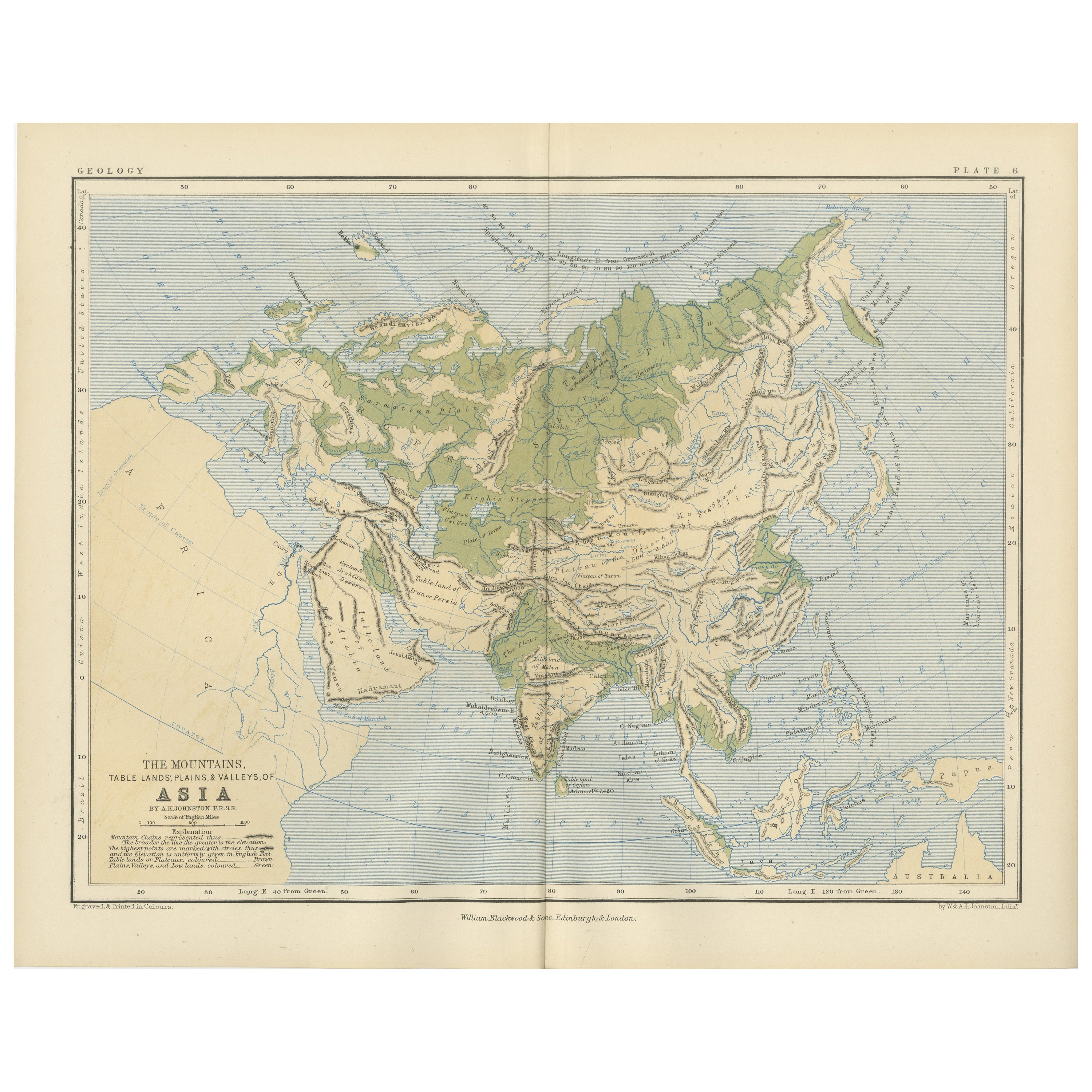
Mostra tuttoGeological Map of Asia by A.K. Johnston – Mountains and Valleys 1852
Geological Map of Asia by A.K. Johnston – Mountains and Valleys 1852
This finely engraved and hand-colored map titled "The Mountains, Table Lands, Plains & Valleys of Asia" was crea...
Categoria
Di antiquariato/d’epoca, Metà XIX secolo, Scozzese, Stampe
Materiali
Carta

306 USD / articolo
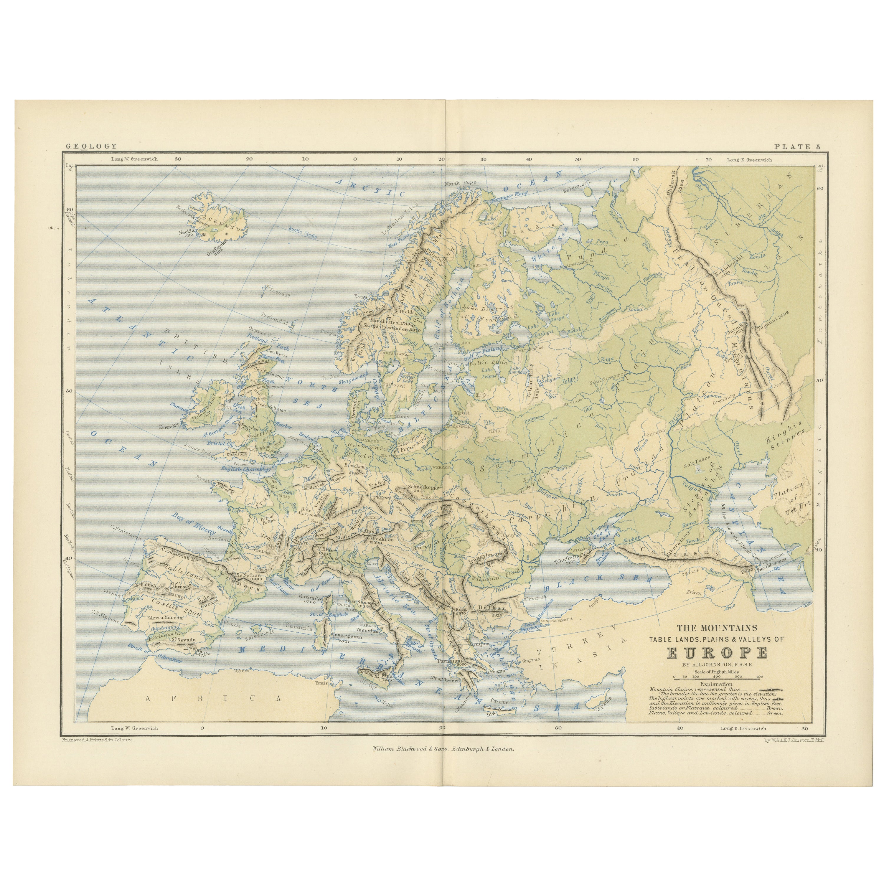
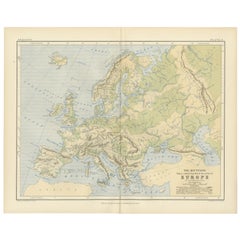
Geological Map of Europe by A.K. Johnston – Mountains and Valleys 1852
Geological Map of Europe by A.K. Johnston – Mountains and Valleys 1852
This elegant 1852 map titled "The Mountains, Table Lands, Plains & Valleys of Europe" was designed by the accl...
Categoria
Di antiquariato/d’epoca, Metà XIX secolo, Scozzese, Stampe
Materiali
Carta
306 USD / articolo
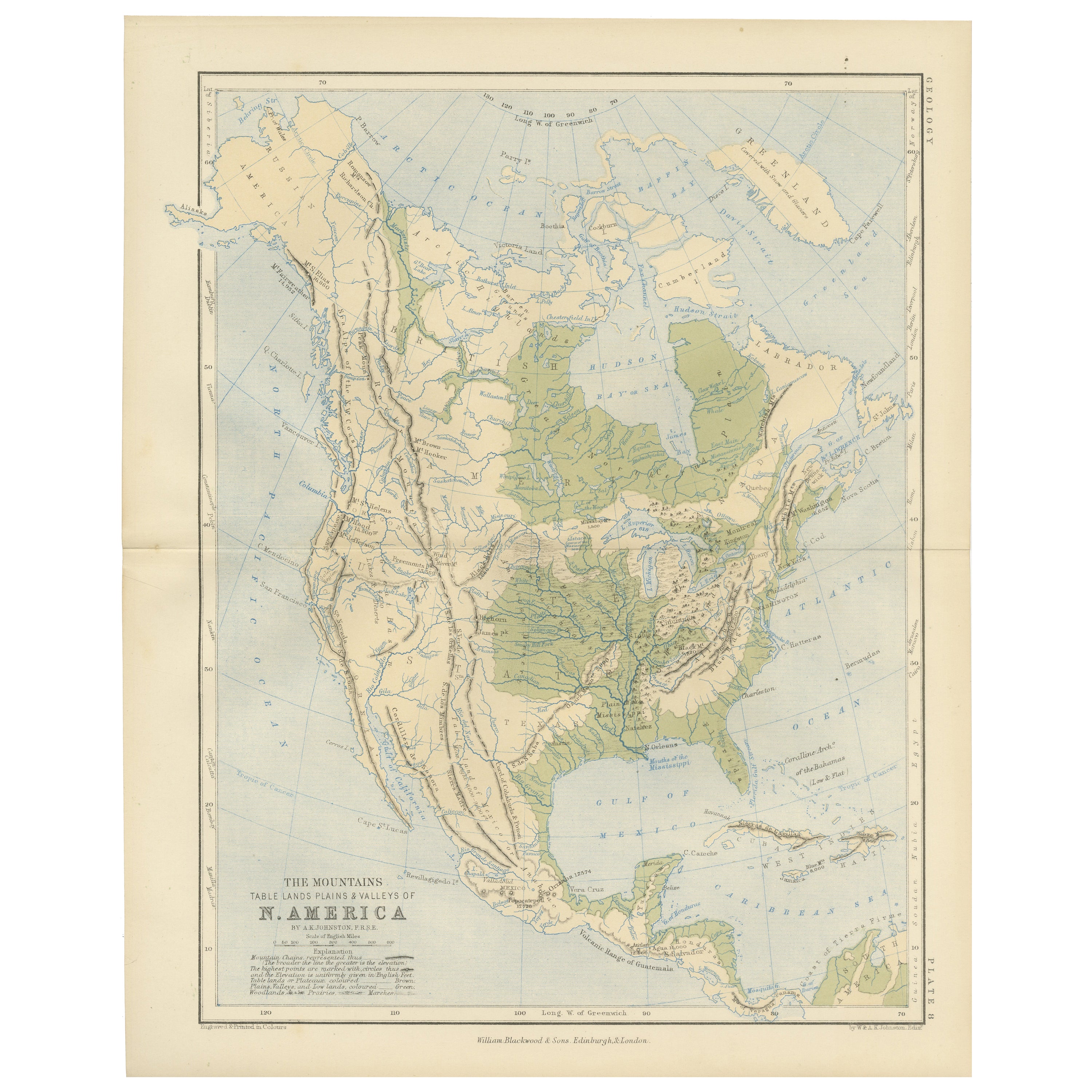
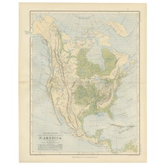
Geological Map of North America by A.K. Johnston – Mountains and Valleys 1852
Geological Map of North America by A.K. Johnston – Mountains and Valleys 1852
This finely detailed and beautifully shaded antique map titled "The Mountains, Table Lands, Plains & Va...
Categoria
Di antiquariato/d’epoca, Metà XIX secolo, Scozzese, Stampe
Materiali
Carta
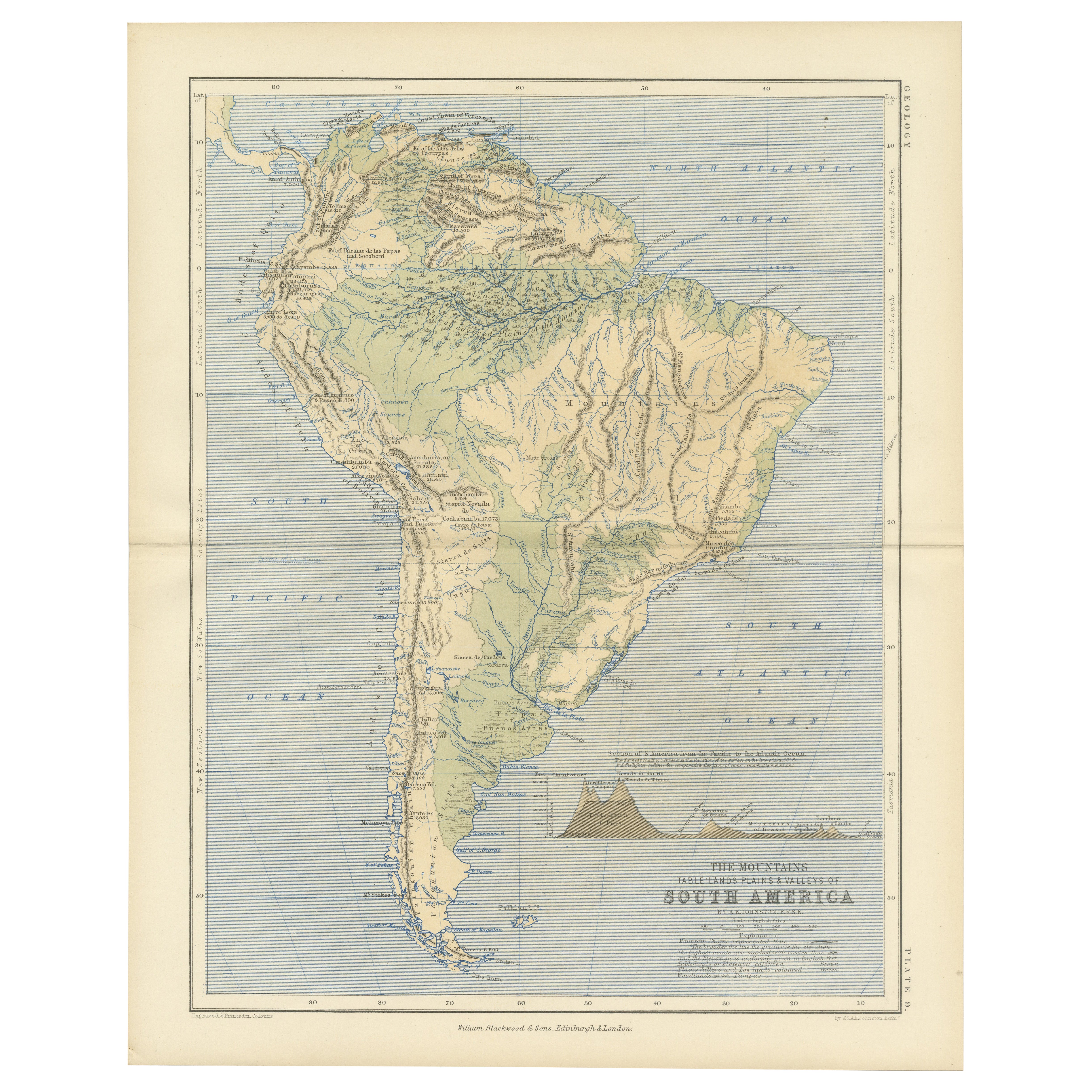
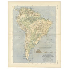
Geological Map of South America by A.K. Johnston – Mountains and Valleys 1852
Geological Map of South America by A.K. Johnston – Mountains and Valleys 1852
This antique map titled "The Mountains, Table Lands, Plains & Valleys of South America" was produced by...
Categoria
Di antiquariato/d’epoca, Metà XIX secolo, Scozzese, Stampe
Materiali
Carta
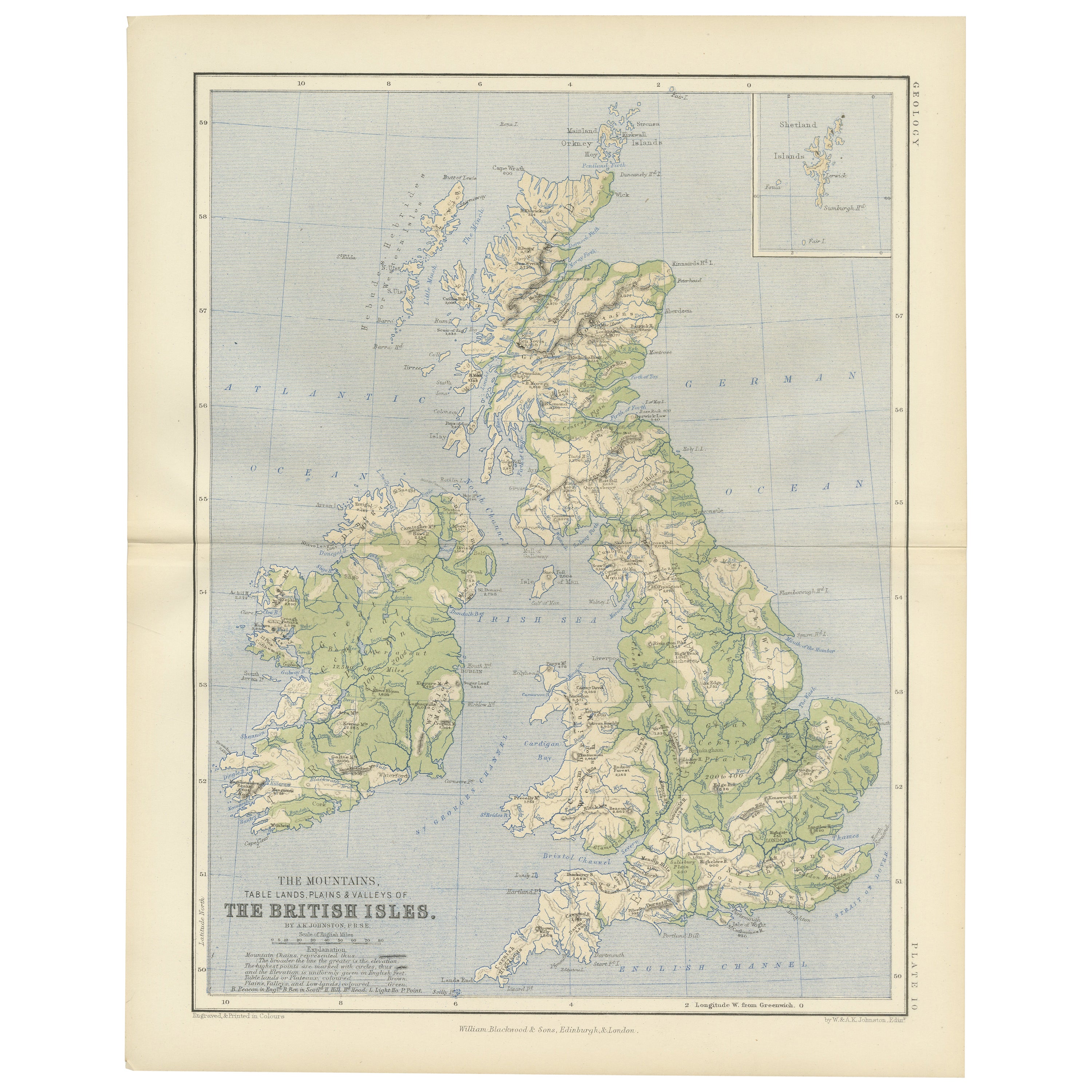
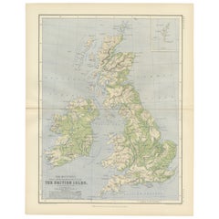
Geological Map of the British Isles by A.K. Johnston – Highlands & Valleys 1852
Geological Map of the British Isles by A.K. Johnston – Highlands & Valleys 1852
This antique topographic map titled "The Mountains, Table Lands, Plains & Valleys of the British Isle...
Categoria
Di antiquariato/d’epoca, Metà XIX secolo, Scozzese, Stampe
Materiali
Carta
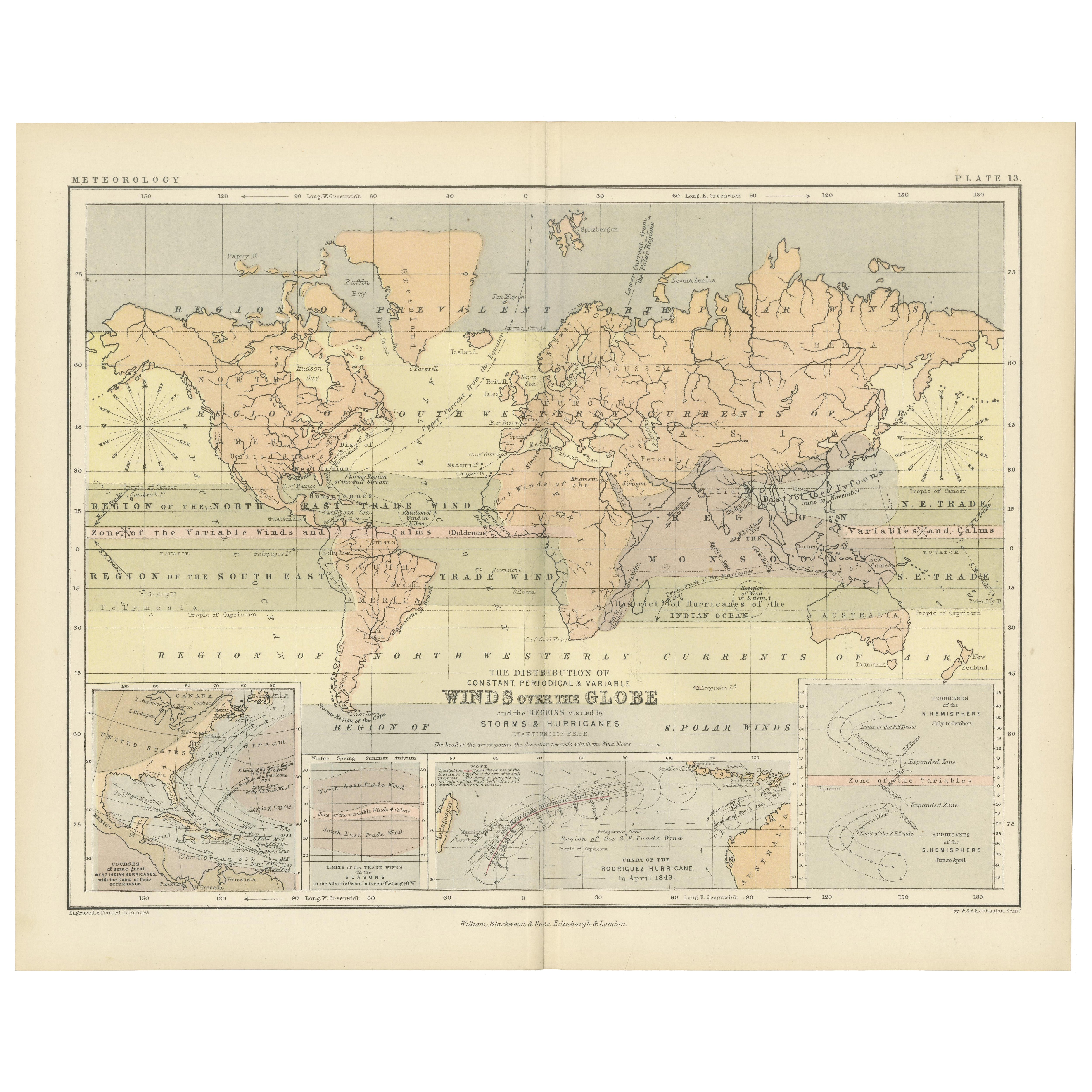
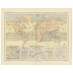
Wind and Hurricane Map by A.K. Johnston – Meteorological Chart 1852
Wind and Hurricane Map by A.K. Johnston – Meteorological Chart 1852
This scientifically significant 1852 map titled "The Distribution of the Constant, Periodical & Variable Winds Ov...
Categoria
Di antiquariato/d’epoca, Metà XIX secolo, Scozzese, Stampe
Materiali
Carta
306 USD / articolo
Ti potrebbe interessare anche
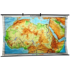
Mappa murale vintage del Nord Africa Countrycore African Wall Chart Decorazione
La mappa a muro mostra il Nord Africa. È stato pubblicato da Westermann-Schulwandkarten. Utilizzato come materiale didattico nelle scuole tedesche. Stampa colorata su carta rinforzat...
Categoria
Fine XX secolo, Tedesco, Country, Stampe
Materiali
Tela, Legno, Carta
Mappa antica originale del Sudafrica, Arrowsmith, 1820
Ottima mappa del Sudafrica.
Disegnato sotto la direzione di Arrowsmith.
Incisione su rame.
Pubblicato da Longman, Hurst, Rees, Orme, & Brown, 1820
Senza cornice.
Categoria
Di antiquariato/d’epoca, Anni 1820, Inglese, Mappe
Materiali
Carta

Africa: Una grande mappa colorata a mano del XVII secolo di Sanson e Jaillot
Di Nicolas Sanson
Questa grande mappa originale dell'Africa incisa su rame e colorata a mano intitolata "L'Afrique divisee suivant l'estendue de ses principales parties ou sont distingues les uns des ...
Categoria
Di antiquariato/d’epoca, Anni 1690, Francese, Mappe
Materiali
Carta

"Africa Vetus": una mappa colorata a mano di Sanson del XVII secolo
Di Nicolas Sanson
Questa mappa originale dell'Africa incisa su rame e colorata a mano, intitolata "Africa Vetus, Nicolai Sanson Christianiss Galliar Regis Geographi", fu originariamente creata da Nich...
Categoria
Di antiquariato/d’epoca, Fine XVII secolo, Francese, Mappe
Materiali
Carta

Costa occidentale dell'Africa, Guinea e Sierra Leone: Una mappa del XVIII secolo di Bellin
Di Jacques-Nicolas Bellin
La mappa in rame di Jacques Bellin intitolata "Partie de la Coste de Guinee Dupuis la Riviere de Sierra Leona Jusquau Cap das Palmas", che raffigura la costa della Guinea e della Sie...
Categoria
Di antiquariato/d’epoca, Metà XVIII secolo, Francese, Mappe
Materiali
Carta

"Nova Barbariae Descriptio", una mappa del Nord Africa colorata a mano del XVII secolo
Di Johannes Janssonius
Questa attraente mappa del Nord Africa originale del XVII secolo, colorata a mano e intitolata "Nova Barbariae Descriptio" di Johannes Janssonius, fu pubblicata a Parigi nel 1635. Co...
Categoria
Di antiquariato/d’epoca, Metà XVII secolo, Olandese, Mappe
Materiali
Carta
