Articoli simili a Geological Map of Asia by A.K. Johnston – Mountains and Valleys 1852
Vuoi altre immagini o video?
Richiedi altre immagini o video al venditore
1 di 11
Geological Map of Asia by A.K. Johnston – Mountains and Valleys 1852
Informazioni sull’articolo
Geological Map of Asia by A.K. Johnston – Mountains and Valleys 1852
This finely engraved and hand-colored map titled "The Mountains, Table Lands, Plains & Valleys of Asia" was created by Alexander Keith Johnston and published in 1852 by William Blackwood & Sons, Edinburgh and London. It is Plate 6 from Johnston’s influential *Physical Atlas of Natural Phenomena*, a landmark in thematic cartography that transformed the way scientific information was visualized and disseminated in the 19th century.
This map provides a physical topography of the Asian continent, distinguishing mountainous regions, elevated plateaus, broad plains, and deep valleys using subtle but effective color gradients and hachuring techniques. It visually separates highland and lowland areas through natural earth tones—green for lower elevations and brown for uplands and ranges—offering a clear sense of the continent’s relief.
Major geographic features such as the Himalayas, the Tibetan Plateau, the Altai and Ural Mountains, the Gobi Desert, and the river basins of the Yangtze, Ganges, and Indus are all meticulously labeled. It also identifies the vast steppes of Central Asia, the fertile valleys of Southeast Asia, and the volcanic chains of the Indonesian archipelago.
Rather than being a political map, this chart focuses on the geological framework of the region, a scientific approach that makes it a valuable tool for understanding the environmental forces shaping the continent. The precise execution reflects Johnston’s background in both geography and engraving, as well as his dedication to making complex data accessible to a broader audience.
Alexander Keith Johnston (1804–1871) was one of the leading figures in 19th-century mapmaking. His *Physical Atlas* was among the first atlases devoted entirely to natural phenomena and was widely used by educators, scientists, and explorers alike. The maps in this series remain some of the finest examples of scientific visualization in antique cartography.
Condition and framing tips:
Excellent condition with light age toning and very clean printed surfaces. Ideal for framing in a black, mahogany, or walnut frame with an ivory, pale green, or warm earth-toned mat to complement the natural hues. A sophisticated addition to any library, study, or collector’s wall.
- Dimensioni:Altezza: 27,4 cm (10,79 in)Larghezza: 34,5 cm (13,59 in)Profondità: 0,2 mm (0,01 in)
- Materiali e tecniche:
- Luogo di origine:
- Periodo:
- Data di produzione:1852
- Condizioni:Very good condition. Light overall toning near the margins. The paper remains strong and well-preserved. Folding line as issued.
- Località del venditore:Langweer, NL
- Numero di riferimento:Venditore: BG-13207-61stDibs: LU3054345386602
Informazioni sul venditore
5,0
Venditore riconosciuto
Questi venditori prestigiosi sono leader del settore e rappresentano il massimo in termini di qualità e design.
Venditore Oro
Venditori Premium con valutazione 4,3+ e tempi di risposta entro 24 ore
Fondazione nel 2009
Venditore 1stDibs dal 2017
2.468 vendite su 1stDibs
Tempo di risposta standard: <1 ora
- SpedizioneRecupero del preventivo…Spedizione da: Langweer, Paesi Bassi
- Politica di reso
Alcune parti di questa pagina sono state tradotte automaticamente. 1stDibs non può garantire che le traduzioni siano corrette. L’inglese è la lingua predefinita del sito.
Garanzia di autenticità
Nell’improbabile caso in cui si verifichi un problema con l’autenticità di un articolo, contattaci entro un anno per ottenere un rimborso completo. DettagliGaranzia di rimborso
Se il tuo articolo non corrisponde alla descrizione, è danneggiato durante il trasporto o non arriva, contattaci entro 7 giorni per un rimborso completo. DettagliAnnullamento entro 24 ore
Hai un periodo di tolleranza di 24 ore per annullare il tuo acquisto, senza necessità di fornire spiegazioni.Venditori professionali selezionati
I nostri venditori di livello internazionale devono aderire a rigorosi standard di servizio e qualità, garantendo l’integrità delle inserzioni.Garanzia miglior prezzo
Se scopri che un venditore ha pubblicato altrove lo stesso articolo a un prezzo più basso, applicheremo lo stesso prezzo.Consegna globale affidabile
La nostra rete di vettori leader del settore offre opzioni di spedizione specializzate in tutto il mondo, inclusa la consegna personalizzata.Altro da questo venditore
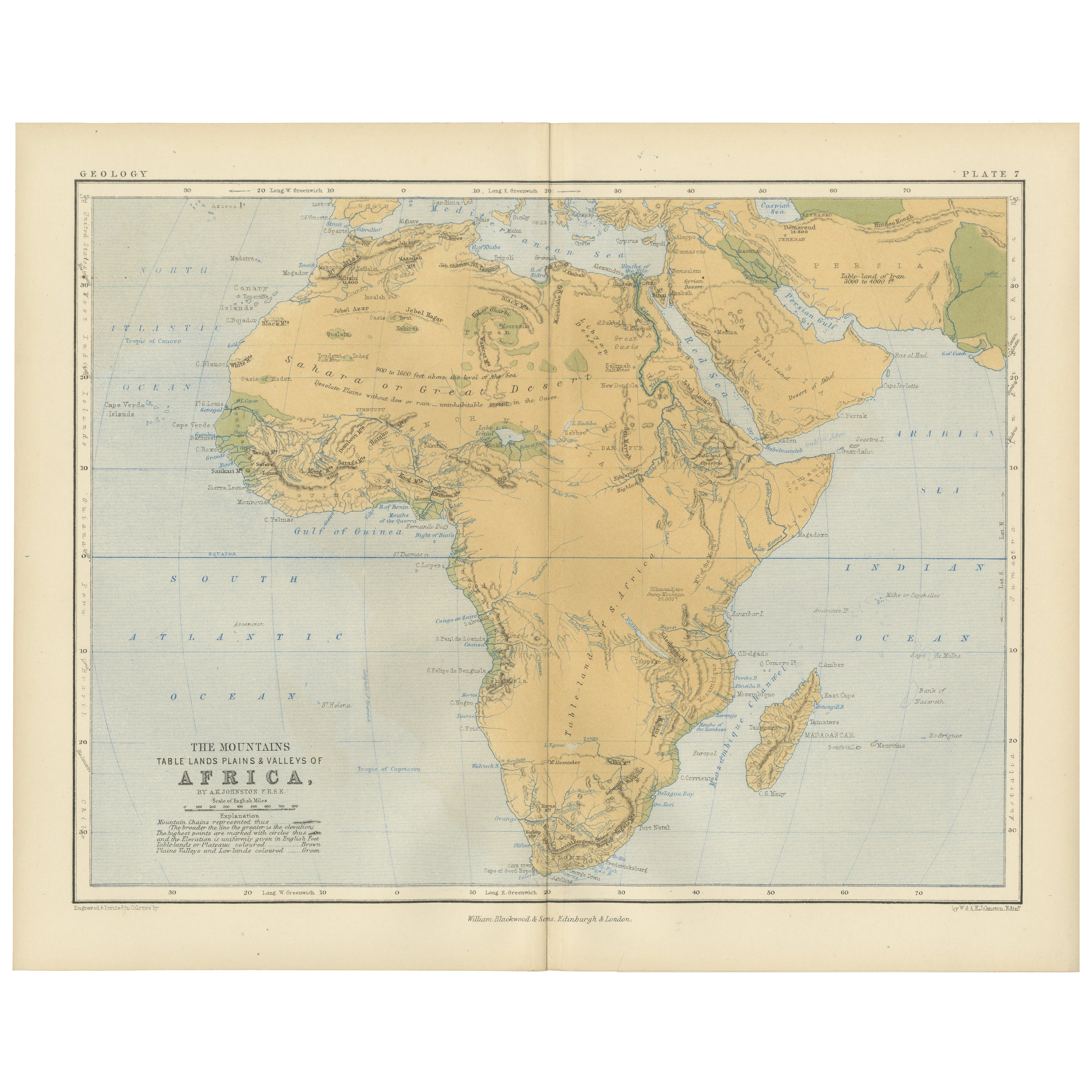
Mostra tuttoGeological Map of Africa by A.K. Johnston – Mountains and Valleys 1852
Geological Map of Africa by A.K. Johnston – Mountains and Valleys 1852
This antique map titled "The Mountains, Table Lands, Plains & Valleys of Africa" was produced by the distingui...
Categoria
Di antiquariato/d’epoca, Metà XIX secolo, Scozzese, Stampe
Materiali
Carta

306 USD / articolo
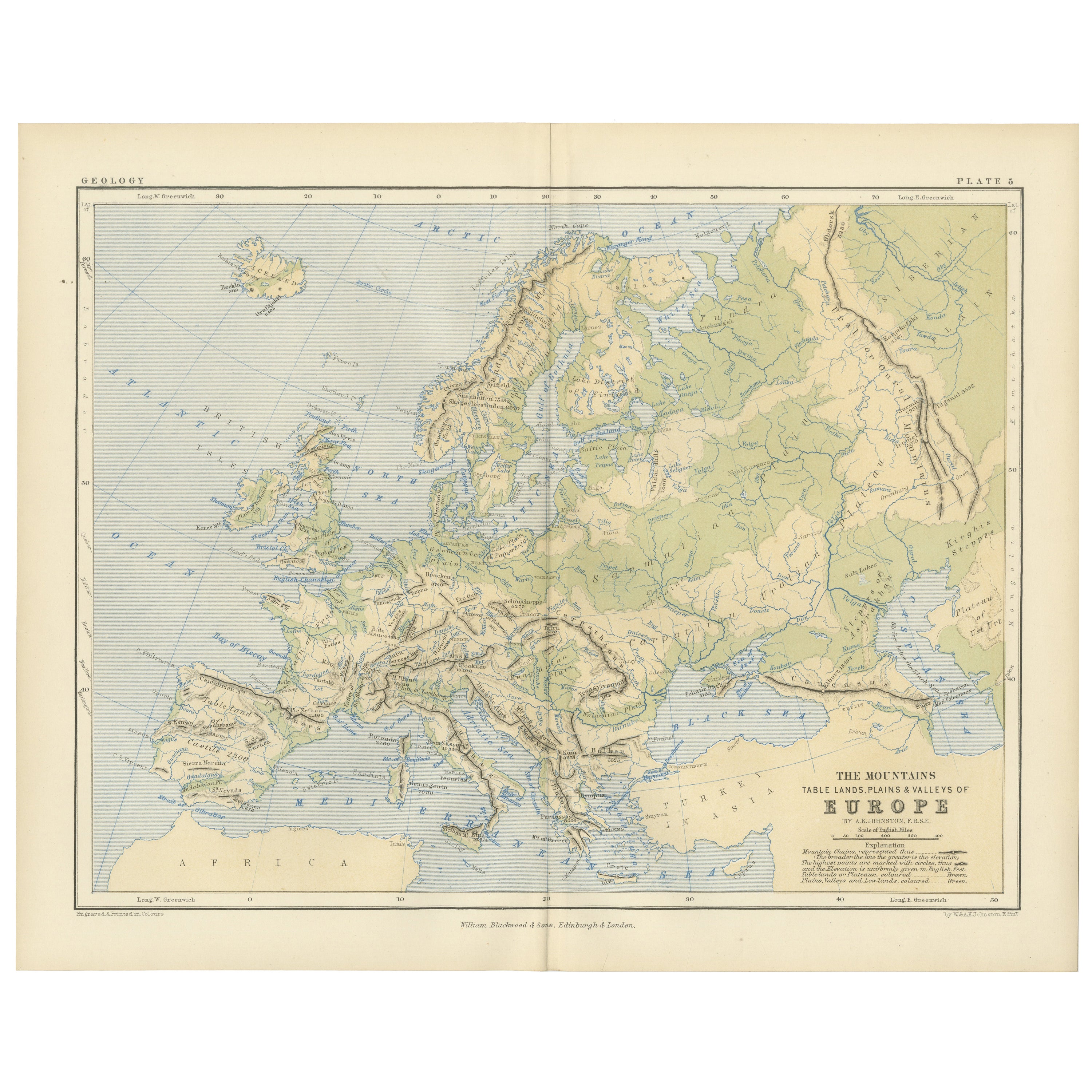
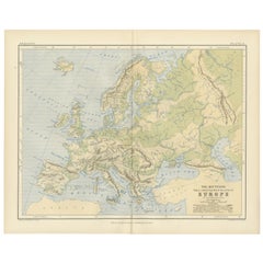
Geological Map of Europe by A.K. Johnston – Mountains and Valleys 1852
Geological Map of Europe by A.K. Johnston – Mountains and Valleys 1852
This elegant 1852 map titled "The Mountains, Table Lands, Plains & Valleys of Europe" was designed by the accl...
Categoria
Di antiquariato/d’epoca, Metà XIX secolo, Scozzese, Stampe
Materiali
Carta
306 USD / articolo
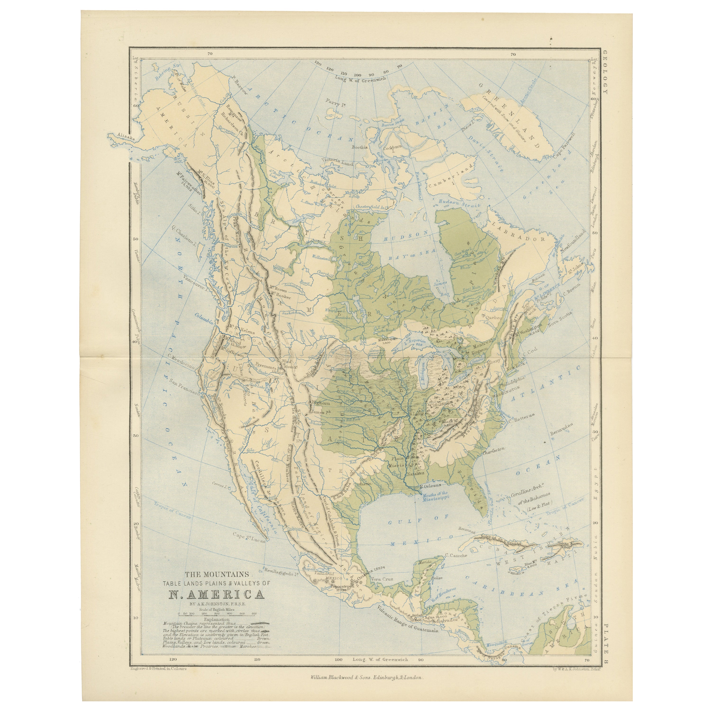
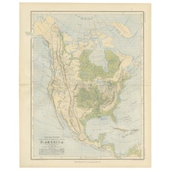
Geological Map of North America by A.K. Johnston – Mountains and Valleys 1852
Geological Map of North America by A.K. Johnston – Mountains and Valleys 1852
This finely detailed and beautifully shaded antique map titled "The Mountains, Table Lands, Plains & Va...
Categoria
Di antiquariato/d’epoca, Metà XIX secolo, Scozzese, Stampe
Materiali
Carta
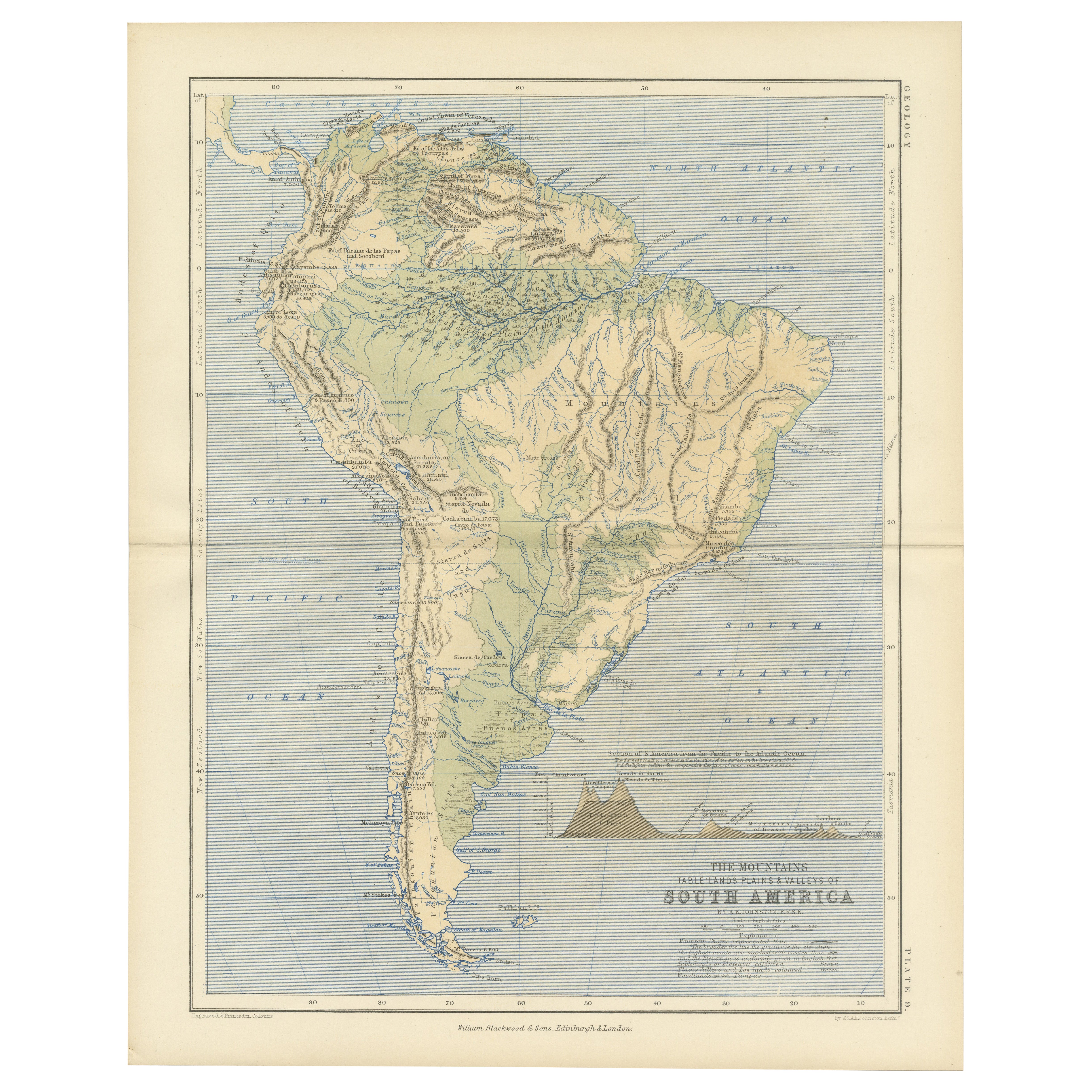
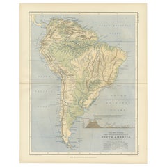
Geological Map of South America by A.K. Johnston – Mountains and Valleys 1852
Geological Map of South America by A.K. Johnston – Mountains and Valleys 1852
This antique map titled "The Mountains, Table Lands, Plains & Valleys of South America" was produced by...
Categoria
Di antiquariato/d’epoca, Metà XIX secolo, Scozzese, Stampe
Materiali
Carta
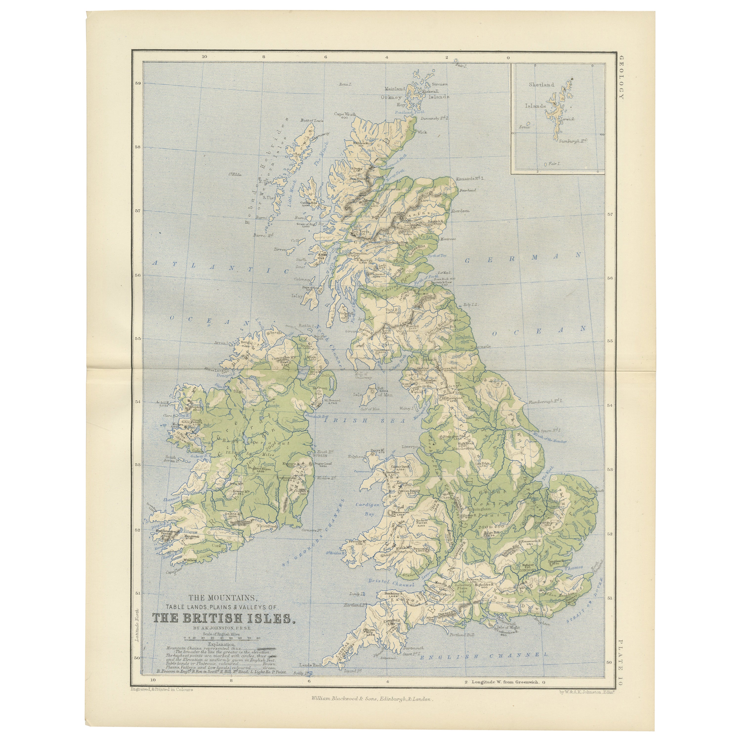
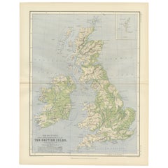
Geological Map of the British Isles by A.K. Johnston – Highlands & Valleys 1852
Geological Map of the British Isles by A.K. Johnston – Highlands & Valleys 1852
This antique topographic map titled "The Mountains, Table Lands, Plains & Valleys of the British Isle...
Categoria
Di antiquariato/d’epoca, Metà XIX secolo, Scozzese, Stampe
Materiali
Carta
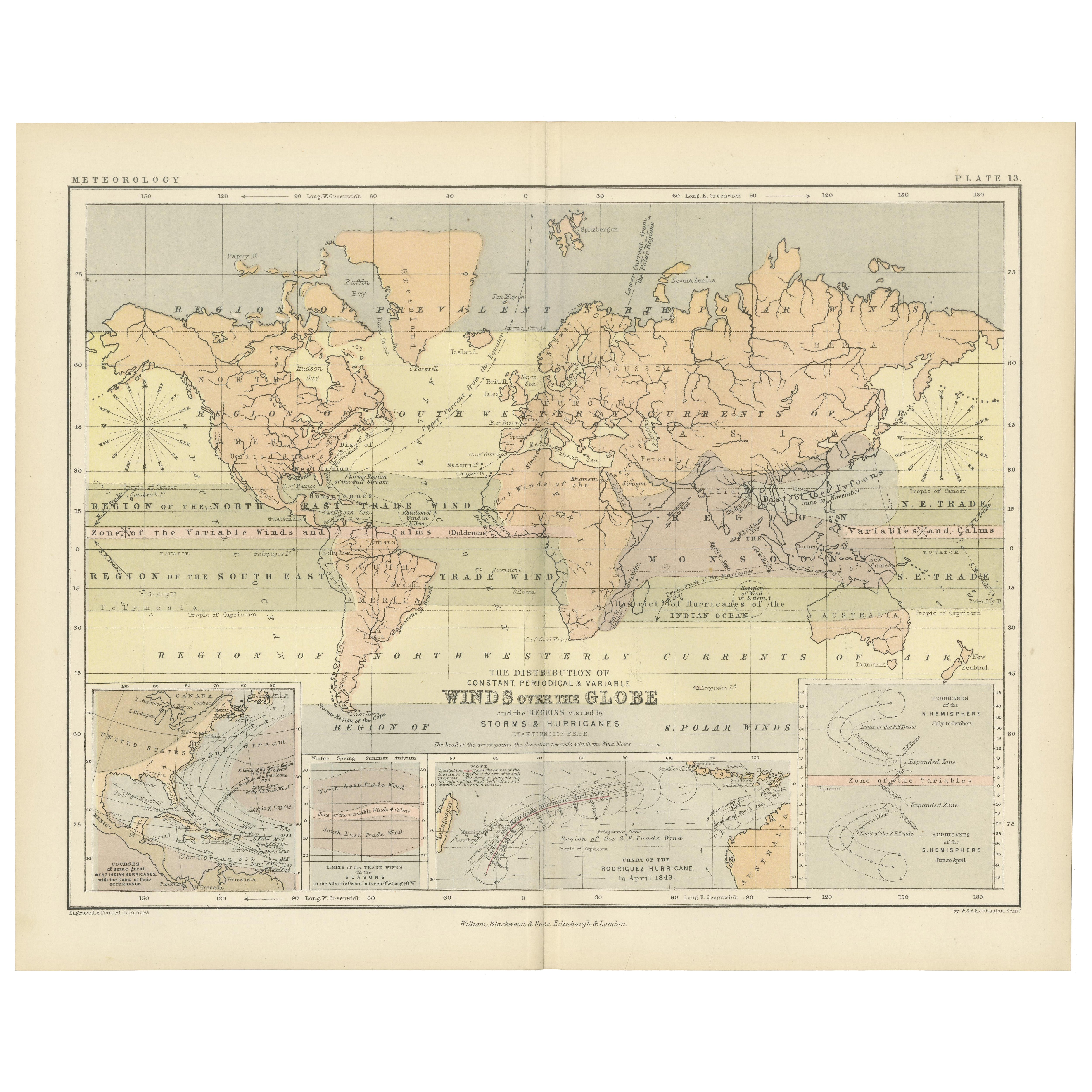
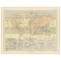
Wind and Hurricane Map by A.K. Johnston – Meteorological Chart 1852
Wind and Hurricane Map by A.K. Johnston – Meteorological Chart 1852
This scientifically significant 1852 map titled "The Distribution of the Constant, Periodical & Variable Winds Ov...
Categoria
Di antiquariato/d’epoca, Metà XIX secolo, Scozzese, Stampe
Materiali
Carta
306 USD / articolo
Ti potrebbe interessare anche
Mappa antica originale dell'Asia sudorientale di Thomas Clerk, 1817
Ottima mappa del Sud Est Asiatico
Incisione su rame
Disegnato e inciso da Thomas Clerk, Edimburgo.
Pubblicato da Mackenzie And Dent, 1817
Senza cornice.
Categoria
Di antiquariato/d’epoca, Anni 1810, Inglese, Mappe
Materiali
Carta

Mappa Homann del Mar Nero, della Turchia e dell'Asia Minore colorata a mano del XVIII secolo
Di Johann Baptist Homann
Un'attraente mappa originale del Mar Nero e della Turchia colorata a mano dell'inizio del XVIII secolo intitolata "Carte de L'Asie Minevre ou de la Natolie et du Pont Evxin Tiree des...
Categoria
Di antiquariato/d’epoca, Inizio XVIII secolo, Tedesco, Mappe
Materiali
Carta

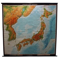
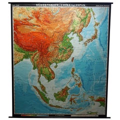
Mappa vintage arrotolabile Southeast Asia Cina Giappone Grafico da parete
Una classica mappa scolastica che mostra la famosa regione del Southeast Asia con Cina e Giappone. Pubblicato da Haack-Painke Justus-Perthes Darmstadt. Stampa colorata su carta rinfo...
Categoria
Fine XX secolo, Tedesco, Country, Stampe
Materiali
Tela, Legno, Carta
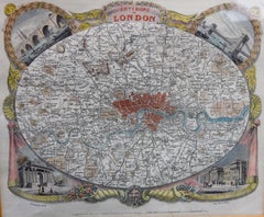
Mappa antica di Londra di Thomas Moule e William Schmollinger
Mappa decorativa di Londra incisa da William Schmollinger per le mappe della contea inglese di Moule. Colorato a mano. Circa 1830.
Categoria
Di antiquariato/d’epoca, Inizio XIX secolo, Inglese, Stampe
Materiali
Carta
Coppia di mappe stradali dell'Inghilterra di John Ogilby
Le prime mappe stradali dell'Inghilterra. Da Londra a Holyhead e da Londra a Carlisle. Ben incorniciato e opacizzato. Si tratta di tavole rimosse da un libro. Si tratta di prime ediz...
Categoria
Di antiquariato/d’epoca, Anni 1690, Inglese, Stampe
Materiali
Carta
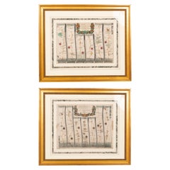
1.850 USD / set
Mappa vintage arrotolabile Asia Giappone Corea Carta da parati Poster Countrycore Decorazione
Una mappa decorativa del nucleo del paese che raffigura il Giappone e la Corea. Pubblicato da Haack-Paincke Justus Perthes. Stampa colorata su carta rinforzata con tela.
Misure:
Larg...
Categoria
Fine XX secolo, Tedesco, Country, Stampe
Materiali
Tela, Legno, Carta