Articoli simili a Geological Map of Europe by A.K. Johnston – Mountains and Valleys 1852
Vuoi altre immagini o video?
Richiedi altre immagini o video al venditore
1 di 10
Geological Map of Europe by A.K. Johnston – Mountains and Valleys 1852
Informazioni sull’articolo
Geological Map of Europe by A.K. Johnston – Mountains and Valleys 1852
This elegant 1852 map titled "The Mountains, Table Lands, Plains & Valleys of Europe" was designed by the acclaimed Scottish geographer Alexander Keith Johnston and published by William Blackwood & Sons, Edinburgh and London. Issued as Plate 5 in Johnston’s pioneering work *The Physical Atlas of Natural Phenomena*, this map presents a physical topographic view of Europe with a focus on land elevation and terrain structure, rather than political borders.
Rendered in soft shades of beige, green, and blue, the map clearly delineates Europe’s major mountain ranges, including the Alps, Pyrenees, Carpathians, Apennines, and the Scandinavian Mountains. Valleys, upland plateaus, and lowlands are carefully shaded and labeled, giving a three-dimensional sense of the landscape. The careful use of hachuring and color gradients creates a tactile impression of Europe’s relief, from the Scottish Highlands to the Ural Mountains.
Rather than showing countries, the map categorizes the land by geological and geomorphological features. The title and key in the lower right explain the distinctions between highlands, tablelands, and low plains, emphasizing natural geography over human boundaries. This approach reflects the 19th-century scientific movement toward thematic cartography—maps made not to navigate or govern, but to understand physical phenomena.
Alexander Keith Johnston (1804–1871), Geographer in Ordinary to the Queen for Scotland, was one of the most respected mapmakers of the Victorian era. His *Physical Atlas* was a groundbreaking work in visual science, and among the first to systematically map climate, geology, hydrology, and landforms across the globe.
This plate is a beautifully executed example of early data visualization and remains highly relevant for collectors of antique scientific prints, students of European geography, or those seeking refined decorative maps for libraries, studies, or offices.
Condition and framing tips:
Very good antique condition with minor toning and slight edge wear. The print retains sharp detail and gentle original coloring. Best displayed in a black or walnut frame with a warm ivory or soft grey mat to highlight the topographic textures and historic typographic style. Ideal for natural history interiors or scholarly settings.
- Dimensioni:Altezza: 27,4 cm (10,79 in)Larghezza: 34,5 cm (13,59 in)Profondità: 0,2 mm (0,01 in)
- Materiali e tecniche:
- Luogo di origine:
- Periodo:
- Data di produzione:1852
- Condizioni:Very good condition. Light overall toning near the margins. The paper remains strong and well-preserved. Folding line as issued.
- Località del venditore:Langweer, NL
- Numero di riferimento:Venditore: BG-13207-51stDibs: LU3054345386522
Informazioni sul venditore
5,0
Venditore riconosciuto
Questi venditori prestigiosi sono leader del settore e rappresentano il massimo in termini di qualità e design.
Venditore Oro
Venditori Premium con valutazione 4,3+ e tempi di risposta entro 24 ore
Fondazione nel 2009
Venditore 1stDibs dal 2017
2.468 vendite su 1stDibs
Tempo di risposta standard: <1 ora
- SpedizioneRecupero del preventivo…Spedizione da: Langweer, Paesi Bassi
- Politica di reso
Alcune parti di questa pagina sono state tradotte automaticamente. 1stDibs non può garantire che le traduzioni siano corrette. L’inglese è la lingua predefinita del sito.
Garanzia di autenticità
Nell’improbabile caso in cui si verifichi un problema con l’autenticità di un articolo, contattaci entro un anno per ottenere un rimborso completo. DettagliGaranzia di rimborso
Se il tuo articolo non corrisponde alla descrizione, è danneggiato durante il trasporto o non arriva, contattaci entro 7 giorni per un rimborso completo. DettagliAnnullamento entro 24 ore
Hai un periodo di tolleranza di 24 ore per annullare il tuo acquisto, senza necessità di fornire spiegazioni.Venditori professionali selezionati
I nostri venditori di livello internazionale devono aderire a rigorosi standard di servizio e qualità, garantendo l’integrità delle inserzioni.Garanzia miglior prezzo
Se scopri che un venditore ha pubblicato altrove lo stesso articolo a un prezzo più basso, applicheremo lo stesso prezzo.Consegna globale affidabile
La nostra rete di vettori leader del settore offre opzioni di spedizione specializzate in tutto il mondo, inclusa la consegna personalizzata.Altro da questo venditore
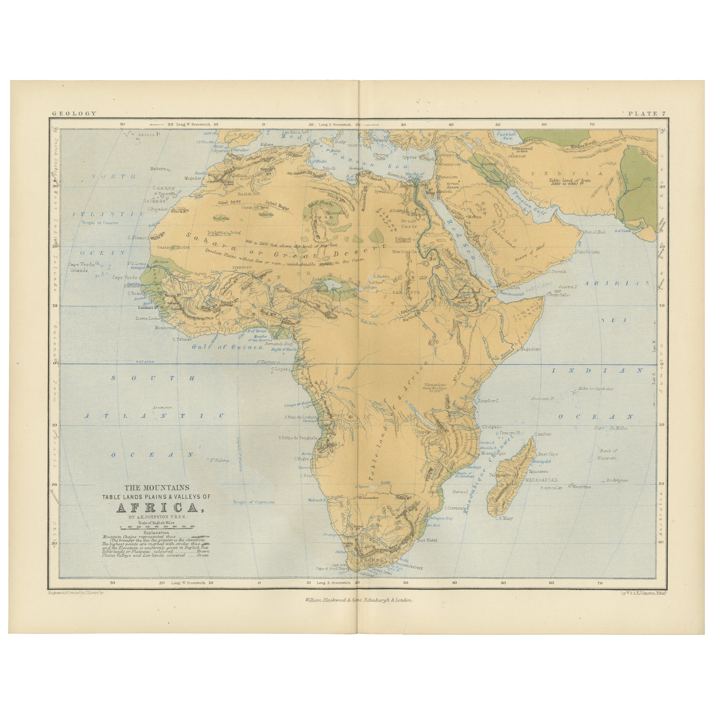
Mostra tuttoGeological Map of Africa by A.K. Johnston – Mountains and Valleys 1852
Geological Map of Africa by A.K. Johnston – Mountains and Valleys 1852
This antique map titled "The Mountains, Table Lands, Plains & Valleys of Africa" was produced by the distingui...
Categoria
Di antiquariato/d’epoca, Metà XIX secolo, Scozzese, Stampe
Materiali
Carta

306 USD / articolo
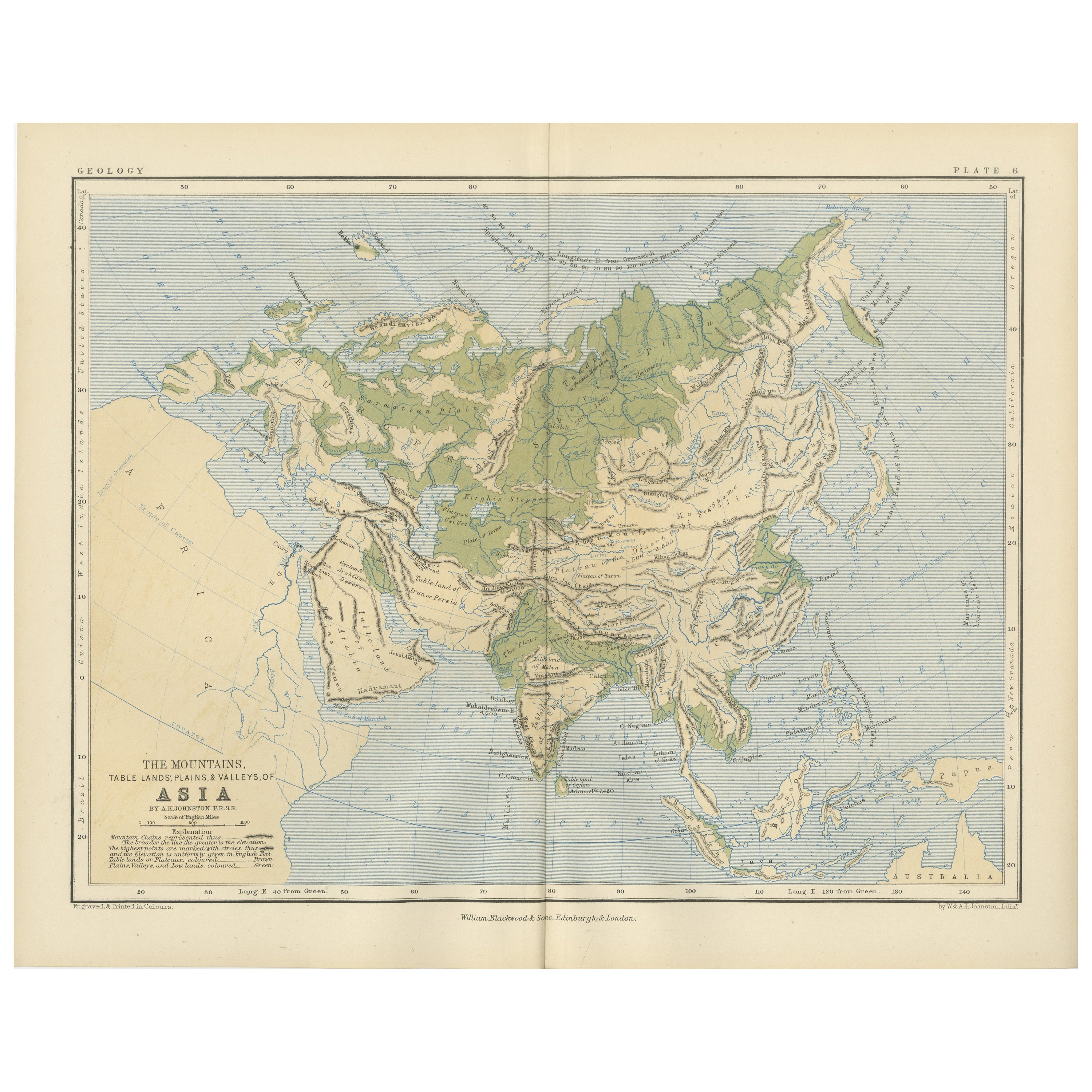
Geological Map of Asia by A.K. Johnston – Mountains and Valleys 1852
Geological Map of Asia by A.K. Johnston – Mountains and Valleys 1852
This finely engraved and hand-colored map titled "The Mountains, Table Lands, Plains & Valleys of Asia" was crea...
Categoria
Di antiquariato/d’epoca, Metà XIX secolo, Scozzese, Stampe
Materiali
Carta

306 USD / articolo
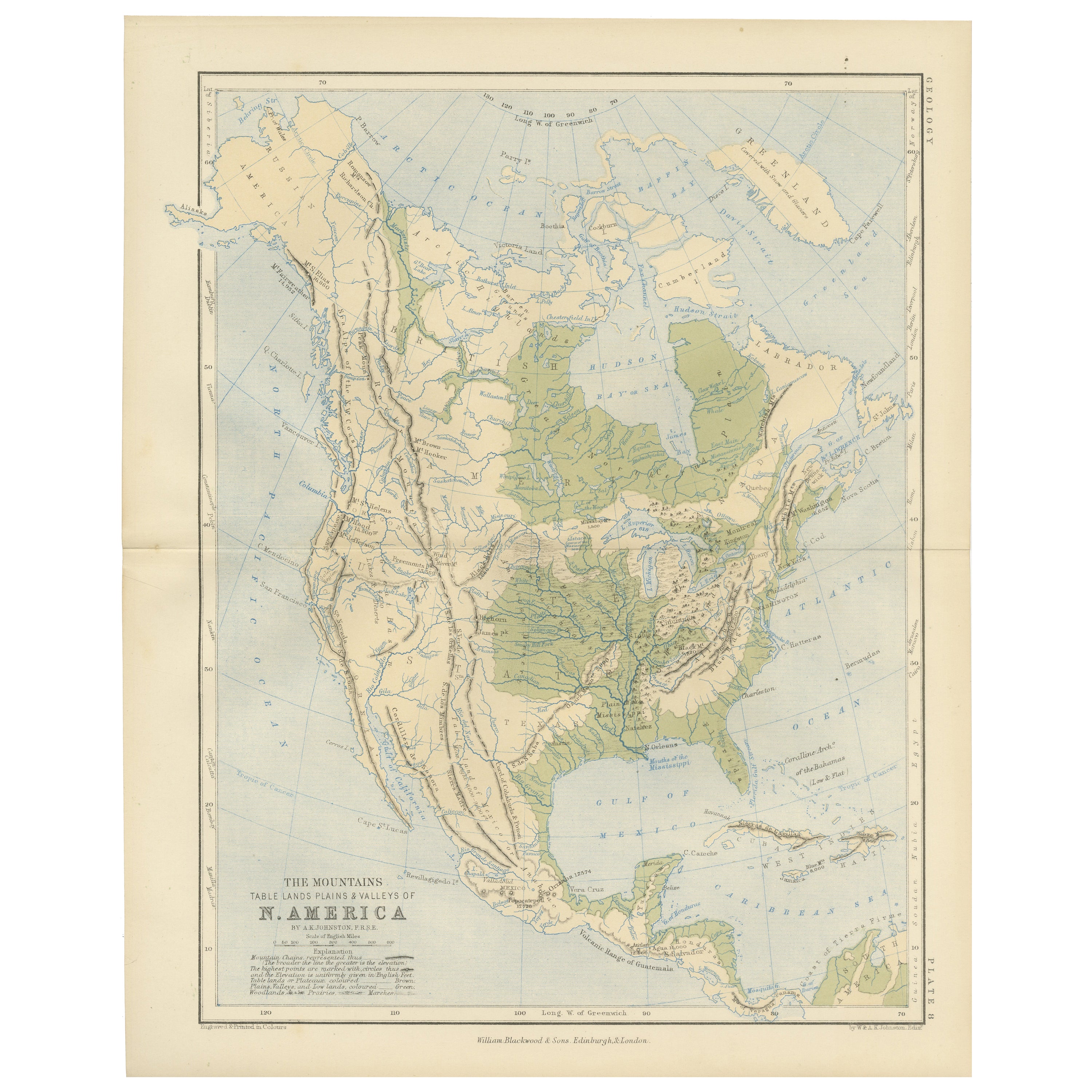
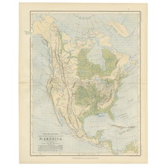
Geological Map of North America by A.K. Johnston – Mountains and Valleys 1852
Geological Map of North America by A.K. Johnston – Mountains and Valleys 1852
This finely detailed and beautifully shaded antique map titled "The Mountains, Table Lands, Plains & Va...
Categoria
Di antiquariato/d’epoca, Metà XIX secolo, Scozzese, Stampe
Materiali
Carta
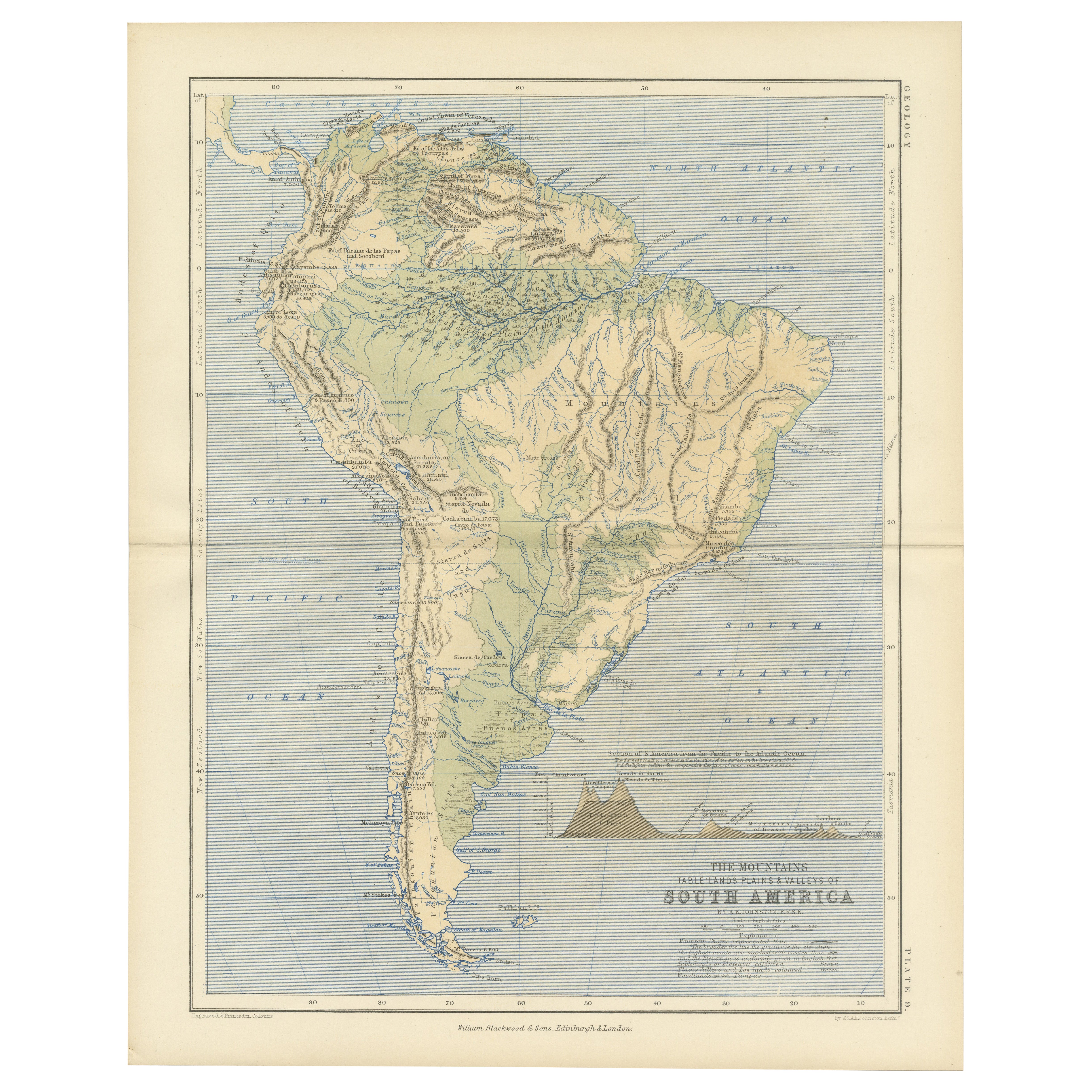
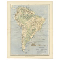
Geological Map of South America by A.K. Johnston – Mountains and Valleys 1852
Geological Map of South America by A.K. Johnston – Mountains and Valleys 1852
This antique map titled "The Mountains, Table Lands, Plains & Valleys of South America" was produced by...
Categoria
Di antiquariato/d’epoca, Metà XIX secolo, Scozzese, Stampe
Materiali
Carta
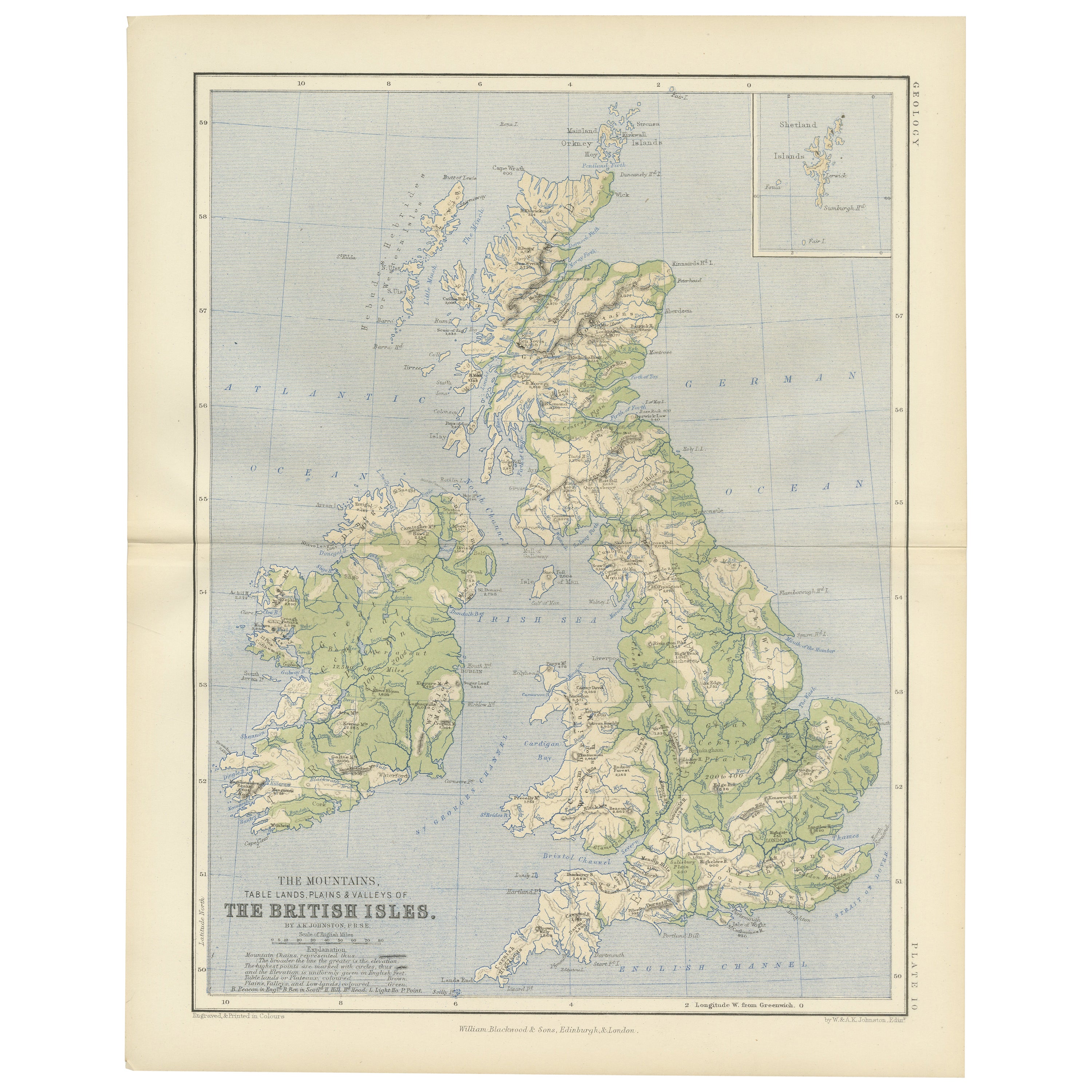
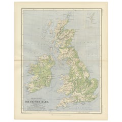
Geological Map of the British Isles by A.K. Johnston – Highlands & Valleys 1852
Geological Map of the British Isles by A.K. Johnston – Highlands & Valleys 1852
This antique topographic map titled "The Mountains, Table Lands, Plains & Valleys of the British Isle...
Categoria
Di antiquariato/d’epoca, Metà XIX secolo, Scozzese, Stampe
Materiali
Carta
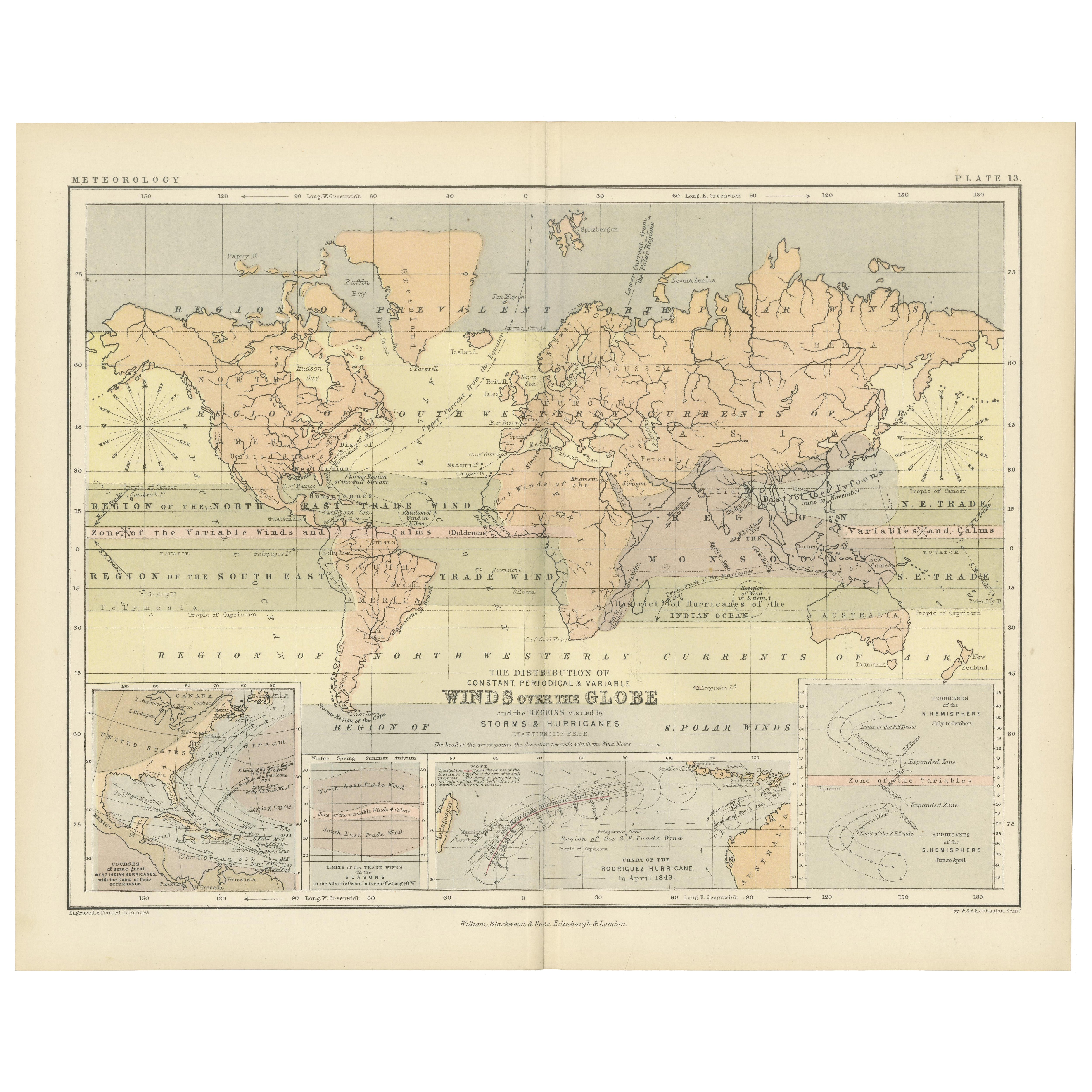
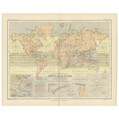
Wind and Hurricane Map by A.K. Johnston – Meteorological Chart 1852
Wind and Hurricane Map by A.K. Johnston – Meteorological Chart 1852
This scientifically significant 1852 map titled "The Distribution of the Constant, Periodical & Variable Winds Ov...
Categoria
Di antiquariato/d’epoca, Metà XIX secolo, Scozzese, Stampe
Materiali
Carta
306 USD / articolo
Ti potrebbe interessare anche
Mappa antica originale dell'Europa, Arrowsmith, 1820
Grande mappa dell'Europa
Disegnato sotto la direzione di Arrowsmith.
Incisione su rame.
Pubblicato da Longman, Hurst, Rees, Orme, & Brown, 1820
Senza cornice.
Categoria
Di antiquariato/d’epoca, Anni 1820, Inglese, Mappe
Materiali
Carta

Europa meridionale e orientale: Una grande mappa colorata a mano del XVII secolo di Sanson & Jaillot
Di Nicolas Sanson
Questa grande mappa colorata a mano intitolata "Estats de L'Empire des Turqs en Europe, ou sont les Beglerbeglicz our Gouvernements" è stata originariamente creata da Nicholas Sanson...
Categoria
Di antiquariato/d’epoca, Anni 1690, Francese, Mappe
Materiali
Carta

Scandinavia e porzioni dell'Europa orientale: carta Homann colorata a mano del XVIII secolo
Di Johann Baptist Homann
Mappa in rame colorata a mano dell'inizio del XVIII secolo intitolata "Regni Sueciae in omnes suas Subjacentes Provincias accurate divisi Tabula Generalis" di Johann Baptist Homann (...
Categoria
Di antiquariato/d’epoca, Inizio XVIII secolo, Tedesco, Mappe
Materiali
Carta

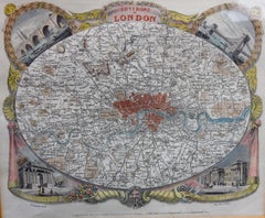
Mappa antica di Londra di Thomas Moule e William Schmollinger
Mappa decorativa di Londra incisa da William Schmollinger per le mappe della contea inglese di Moule. Colorato a mano. Circa 1830.
Categoria
Di antiquariato/d’epoca, Inizio XIX secolo, Inglese, Stampe
Materiali
Carta
Mappa d'Europa d'epoca con cornice in Wood Freijo e rosette in ottone
Mappa d'Europa d'epoca con cornice in Wood Freijo e rosette in ottone
In vendita c'è una mappa d'epoca dell'Europa splendidamente incorniciata sotto vetro in legno freijo brasiliano...
Categoria
Inizio anni 2000, Brasiliano, Stampe
Materiali
Vetro, Legno, Carta

Coppia di mappe stradali dell'Inghilterra di John Ogilby
Le prime mappe stradali dell'Inghilterra. Da Londra a Holyhead e da Londra a Carlisle. Ben incorniciato e opacizzato. Si tratta di tavole rimosse da un libro. Si tratta di prime ediz...
Categoria
Di antiquariato/d’epoca, Anni 1690, Inglese, Stampe
Materiali
Carta
1.850 USD / set