Articoli simili a Rain and Snow Map by A.K. Johnston – Global Precipitation Chart 1852


Vuoi altre immagini o video?
Richiedi altre immagini o video al venditore
1 di 11
Rain and Snow Map by A.K. Johnston – Global Precipitation Chart 1852
260 €per articolo|IVA inclusa
Quantità
Informazioni sull’articolo
Rain and Snow Map by A.K. Johnston – Global Precipitation Chart 1852
This antique meteorological chart titled "The Distribution of Rain and Snow over the Globe" was created by Alexander Keith Johnston and published in 1852 by William Blackwood & Sons in Edinburgh and London. It is Plate 14 from Johnston’s groundbreaking *Physical Atlas of Natural Phenomena*, a landmark 19th-century atlas that visually documented natural science using elegant cartographic design.
This thematic map represents one of the earliest global attempts to chart patterns of precipitation, displaying how rainfall and snowfall vary according to geography, latitude, topography, and proximity to oceans. The map divides the world into meteorological zones based on the frequency and regularity of rainfall. Shaded bands mark areas of constant equatorial rainfall, seasonal monsoon regions, zones of periodic tropical downpours, and drier arid zones such as the Sahara, Arabian Peninsula, central Australia, and western South America.
The map is annotated with explanatory observations, including statements such as “rains fall only at night and early morning” and “rains accompany heat and decrease with altitude,” reflecting the 19th-century state of meteorological knowledge. Areas with snowfall or extremely low precipitation are also marked, highlighting the climatological variety across continents.
In addition to the main map, the plate includes three detailed diagrams:
* A vertical section comparing snow-line elevations across different mountain ranges worldwide.
* A graph illustrating the relationship between precipitation and temperature.
* A chart showing how rainfall decreases with increasing distance from coastal regions.
Johnston (1804–1871), Geographer in Ordinary to Queen Victoria in Scotland, was among the first to bring natural science into the visual domain through cartography. His *Physical Atlas* is considered one of the most influential works of 19th-century thematic mapping, and this plate is a remarkable example of its ambition and execution.
This print offers collectors and scholars a glimpse into early meteorological theory and global climatology. Its elegant engraving and carefully hand-colored zones also make it an attractive decorative item for libraries, offices, and scientific interiors.
Condition and framing tips:
Good condition with light toning and mild signs of age near the edges. Printed surface clean and crisp. Best framed in dark wood or matte black with a neutral or parchment mat to bring out the warm tonal shading of the climatic zones. A refined and thought-provoking piece for any natural science or vintage cartography collection.
- Dimensioni:Altezza: 27,4 cm (10,79 in)Larghezza: 34,5 cm (13,59 in)Profondità: 0,2 mm (0,01 in)
- Materiali e tecniche:
- Luogo di origine:
- Periodo:
- Data di produzione:1852
- Condizioni:Very good condition. Light overall toning near the margins. The paper remains strong and well-preserved. Folding line as issued.
- Località del venditore:Langweer, NL
- Numero di riferimento:Venditore: BG-13207-141stDibs: LU3054345393472
Informazioni sul venditore
5,0
Venditore riconosciuto
Questi venditori prestigiosi sono leader del settore e rappresentano il massimo in termini di qualità e design.
Venditore Platino
Venditori Premium con valutazione 4.7+ e tempi di risposta entro 24 ore
Fondazione nel 2009
Venditore 1stDibs dal 2017
2641 vendite su 1stDibs
Tempo di risposta standard: <1 ora
- SpedizioneRecupero del preventivo…Spedizione da: Langweer, Paesi Bassi
- Politica di reso
Alcune parti di questa pagina sono state tradotte automaticamente. 1stDibs non può garantire che le traduzioni siano corrette. L’inglese è la lingua predefinita del sito.
Garanzia di autenticità
Nell’improbabile caso in cui si verifichi un problema con l’autenticità di un articolo, contattaci entro un anno per ottenere un rimborso completo. DettagliGaranzia di rimborso
Se il tuo articolo non corrisponde alla descrizione, è danneggiato durante il trasporto o non arriva, contattaci entro 7 giorni per un rimborso completo. DettagliAnnullamento entro 24 ore
Hai un periodo di tolleranza di 24 ore per annullare il tuo acquisto, senza necessità di fornire spiegazioni.Venditori professionali selezionati
I nostri venditori di livello internazionale devono aderire a rigorosi standard di servizio e qualità, garantendo l’integrità delle inserzioni.Garanzia miglior prezzo
Se scopri che un venditore ha pubblicato altrove lo stesso articolo a un prezzo più basso, applicheremo lo stesso prezzo.Consegna globale affidabile
La nostra rete di vettori leader del settore offre opzioni di spedizione specializzate in tutto il mondo, inclusa la consegna personalizzata.Altro da questo venditore
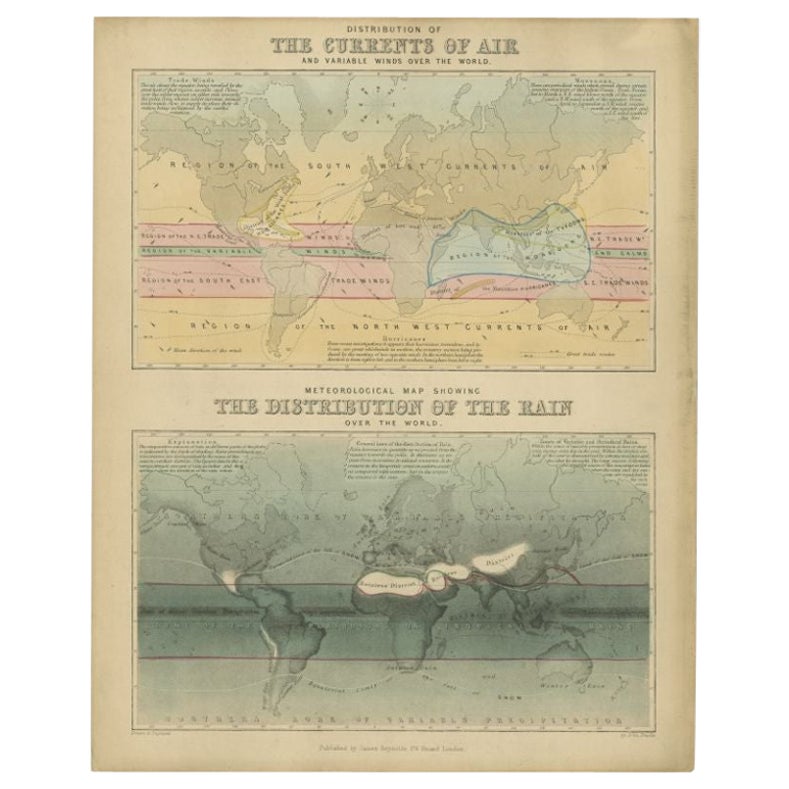
Mostra tuttoCarta antica della distribuzione dell'aria e della pioggia di Reynolds, 1843
Due antiche mappe del mondo su un unico foglio. La mappa superiore mostra la distribuzione delle correnti d'aria e dei venti variabili nel mondo. La mappa meteorologica inferiore mos...
Categoria
Di antiquariato/d’epoca, XIX secolo, Mappe
Materiali
Carta
143 € Prezzo promozionale
20% in meno
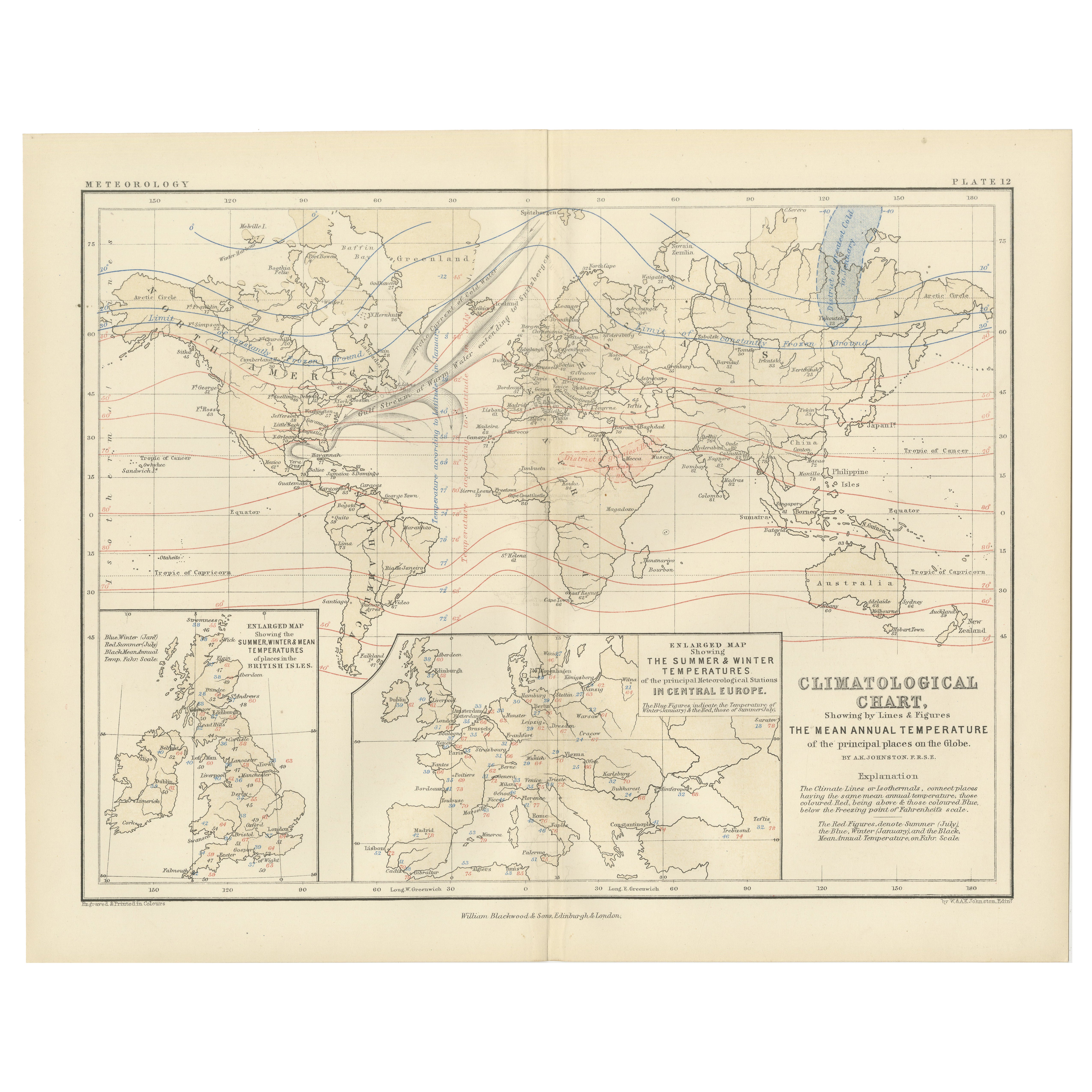
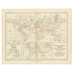
Climatological Map by A.K. Johnston – Global Temperatures Chart 1852
Climatological Map by A.K. Johnston – Global Temperatures Chart 1852
This exceptional antique map titled "Climatological Chart Showing by Lines & Figures the Mean Annual Temperature...
Categoria
Di antiquariato/d’epoca, Metà XIX secolo, Scozzese, Stampe
Materiali
Carta
Carta della pioggia antica del mondo di Johnston del 1850
Carta geografica antica intitolata "Carta ietografica o della pioggia del mondo". Mappa della pioggia originale e antica del mondo. Questa mappa proviene da 'The Physical Atlas of Na...
Categoria
Di antiquariato/d’epoca, Metà XIX secolo, Mappe
Materiali
Carta

160 € Prezzo promozionale
20% in meno
Wind and Hurricane Map by A.K. Johnston – Meteorological Chart 1852
Wind and Hurricane Map by A.K. Johnston – Meteorological Chart 1852
This scientifically significant 1852 map titled "The Distribution of the Constant, Periodical & Variable Winds Ov...
Categoria
Di antiquariato/d’epoca, Metà XIX secolo, Scozzese, Stampe
Materiali
Carta

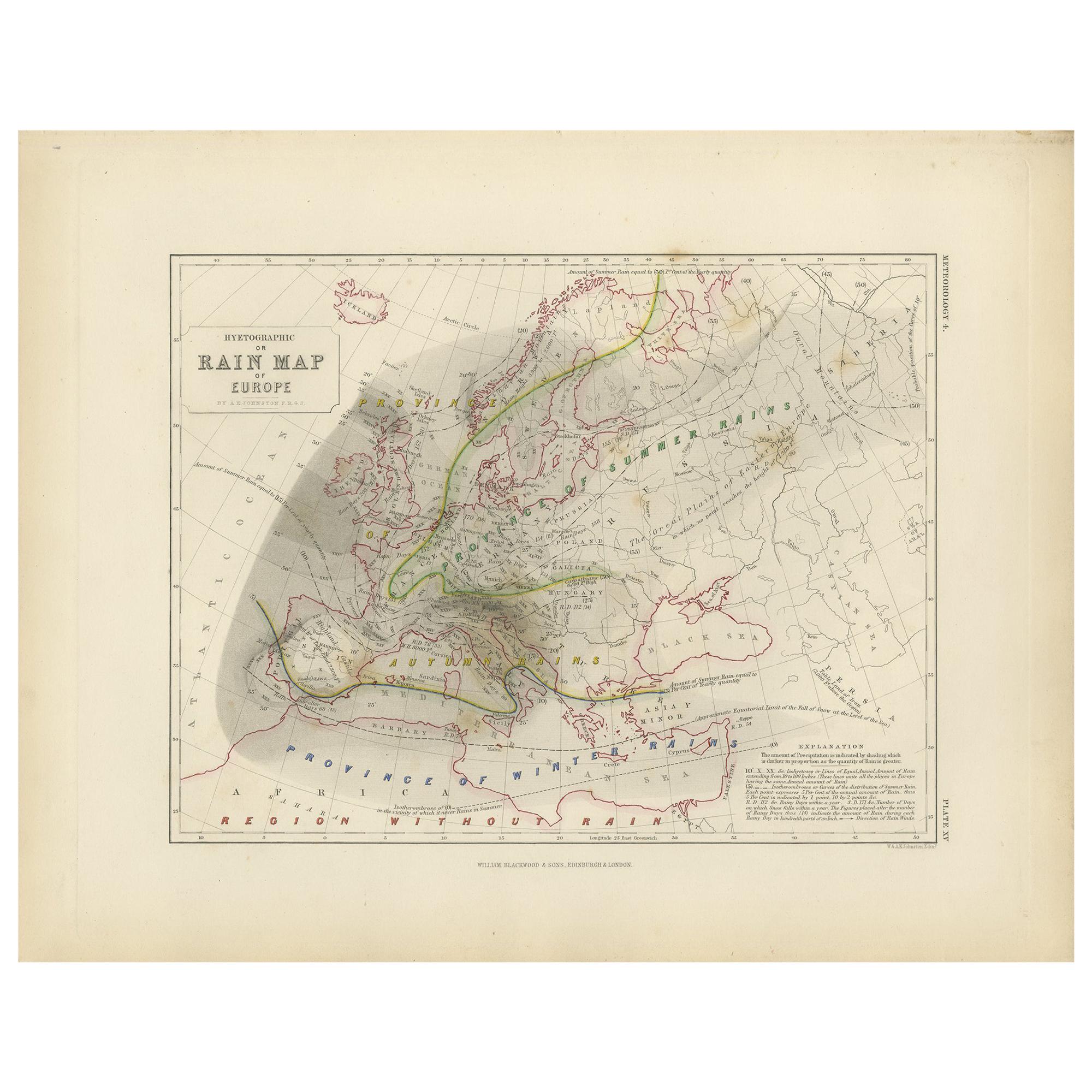
Carta geografica antica dell'Europa di Johnston del 1850
Carta geografica antica intitolata "Carta ietografica o della pioggia dell'Europa". Carta pluviale originale d'epoca dell'Europa. Questa mappa proviene da 'The Physical Atlas of Natu...
Categoria
Di antiquariato/d’epoca, Metà XIX secolo, Mappe
Materiali
Carta

160 € Prezzo promozionale
20% in meno
Mappa antica del mondo che mostra la distribuzione di piante e minerali, 1872
Carta geografica antica intitolata "Il mondo di Johnson che mostra la distribuzione degli alberi forestali caratteristici (...)". Mappa del mondo originale che mostra la distribuzion...
Categoria
Di antiquariato/d’epoca, Fine XIX secolo, Mappe
Materiali
Carta

160 € Prezzo promozionale
20% in meno
Ti potrebbe interessare anche
Mappa del mondo - Acquaforte originale - 1820
La Mappa del Mondo è un'acquaforte originale realizzata da un artista sconosciuto del XIX secolo nel 1820.
Ottimo stato su due fogli di carta bianca uniti al centro.
La mappa è un'...
Categoria
Anni 1820, Moderno, Stampe figurative
Materiali
Acquaforte

Emisfero del Nuovo Continente - Mappa antica di J. J. Heck - 1834.
Di Johann Georg Heck
Emisfero del Nuovo Continente è un'opera d'arte realizzata intorno al 1760 da Johann Georg Heck
Stampa originale a colori.
Buone condizioni, a parte l'ingiallimento della carta e ...
Categoria
Anni 1830, Moderno, Stampe figurative
Materiali
Acquaforte

487 € Prezzo promozionale
25% in meno
1864 Planisfero originale illustrato - Mappa del mondo - Geografia
Immergiti nell'epico viaggio del passato con il Planisfero Storico Illustrato del 1864 di Charpentier! 🗺️ Questo tesoro cartografico ti trasporta attraverso le complessità della sto...
Categoria
Anni 1860, Stampe e riproduzioni
Materiali
Lino, Litografia, Carta

Mappa antica originale del mondo di Thomas Clerk, 1817
Grande mappa dell'emisfero orientale e occidentale
Su 2 fogli
Incisione su rame
Disegnato e inciso da Thomas Clerk, Edimburgo.
Pubblicato da Mackenzie And Dent, 1817
N...
Categoria
Di antiquariato/d’epoca, Anni 1810, Inglese, Mappe
Materiali
Carta

Mappa dell'Impero Britannico - Mappa antica di Karl Spruner - 1760 ca.
Di Karl Spruner von Merz
La Mappa dell'Impero Britannico è un'opera d'arte realizzata intorno al 1760 da Karl Spruner.
Stampa originale colorata a mano.
Buone condizioni, a parte l'ingiallimento della cart...
Categoria
Anni 1760, Moderno, Stampe figurative
Materiali
Acquaforte

210 € Prezzo promozionale
25% in meno
Mappa antica originale del mondo di Dower, 1835 circa
Bella mappa del mondo
Disegnato e inciso da J.Dower
Pubblicato da Orr & Smith. C.1835
Senza cornice.
Spedizione gratuita
Categoria
Di antiquariato/d’epoca, Anni 1830, Inglese, Mappe
Materiali
Carta
