Articoli simili a Religious Belief Map by A.K. Johnston – Moral and Statistical Chart 1852


Vuoi altre immagini o video?
Richiedi altre immagini o video al venditore
1 di 11
Religious Belief Map by A.K. Johnston – Moral and Statistical Chart 1852
260 €per articolo|IVA inclusa
Quantità
Informazioni sull’articolo
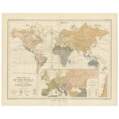
Religious Belief Map by A.K. Johnston – Moral and Statistical Chart 1852
This antique chart titled "Moral & Statistical Chart Showing the Distribution of Man According to Prevailing Forms of Religious Belief & the Proportionate Number of Each Creed in the Principal States of the Globe" was created by Alexander Keith Johnston and published in 1852 by William Blackwood & Sons in Edinburgh and London. Issued as Plate 18 in Johnston’s *Physical Atlas of Natural Phenomena*, this map is a rare and historically significant early attempt to visualize global religious demographics.
The world is color-coded to reflect the dominant religions in various regions, including Christianity (with Roman Catholic, Greek Orthodox, and Protestant branches distinguished), Islam (Sunni and Shiite), Buddhism, Brahmanism (Hinduism), Judaism, and areas broadly labeled as "Heathen" or "Other Faiths," in accordance with 19th-century terminology. The color-coded legend to the lower right includes estimated numbers of adherents for each group, offering a numerical context to the geographic distribution.
Each country or empire is labeled with estimates of its religious composition and population size, from the British Isles and Ottoman Empire to China, Russia, India, and the Americas. The chart reflects not only religious spread, but also the political-religious affiliations of empires and colonial powers during the mid-19th century.
At the bottom of the chart is a diagram titled “Progress of Education,” using bar graphs to compare levels of literacy and schooling across nations—an early example of combining moral and statistical inquiry through cartography. Countries such as Prussia, Scotland, and Saxony rank highest in this education index, while others show much lower rates of public instruction, as interpreted from available data at the time.
Alexander Keith Johnston (1804–1871), Geographer in Ordinary to Queen Victoria in Scotland, was a pioneer in thematic and scientific cartography. His *Physical Atlas* was one of the first atlases to integrate human, environmental, and physical data into visually compelling and educational maps.
This plate is of particular interest to collectors of religious history, antique data visualization, and 19th-century worldviews. It reflects the empirical spirit of the age, while also serving as a historical document of cultural perspectives from a European scientific lens.
Condition and framing tips:
Very good antique condition with some mild age toning and a clean printed surface. Original centerfold as issued. Frame in a dark or neutral wood with a cream or parchment mat to complement the subtle pastel palette and enhance legibility. Ideal for display in a study, library, or historical institution.
- Dimensioni:Altezza: 27,4 cm (10,79 in)Larghezza: 34,5 cm (13,59 in)Profondità: 0,2 mm (0,01 in)
- Materiali e tecniche:
- Luogo di origine:
- Periodo:
- Data di produzione:1852
- Condizioni:Very good condition. Light overall toning near the margins. The paper remains strong and well-preserved. Folding line as issued.
- Località del venditore:Langweer, NL
- Numero di riferimento:Venditore: BG-13207-181stDibs: LU3054345393582
Informazioni sul venditore
5,0
Venditore riconosciuto
Questi venditori prestigiosi sono leader del settore e rappresentano il massimo in termini di qualità e design.
Venditore Platino
Venditori Premium con valutazione 4.7+ e tempi di risposta entro 24 ore
Fondazione nel 2009
Venditore 1stDibs dal 2017
2641 vendite su 1stDibs
Tempo di risposta standard: <1 ora
- SpedizioneRecupero del preventivo…Spedizione da: Langweer, Paesi Bassi
- Politica di reso
Alcune parti di questa pagina sono state tradotte automaticamente. 1stDibs non può garantire che le traduzioni siano corrette. L’inglese è la lingua predefinita del sito.
Garanzia di autenticità
Nell’improbabile caso in cui si verifichi un problema con l’autenticità di un articolo, contattaci entro un anno per ottenere un rimborso completo. DettagliGaranzia di rimborso
Se il tuo articolo non corrisponde alla descrizione, è danneggiato durante il trasporto o non arriva, contattaci entro 7 giorni per un rimborso completo. DettagliAnnullamento entro 24 ore
Hai un periodo di tolleranza di 24 ore per annullare il tuo acquisto, senza necessità di fornire spiegazioni.Venditori professionali selezionati
I nostri venditori di livello internazionale devono aderire a rigorosi standard di servizio e qualità, garantendo l’integrità delle inserzioni.Garanzia miglior prezzo
Se scopri che un venditore ha pubblicato altrove lo stesso articolo a un prezzo più basso, applicheremo lo stesso prezzo.Consegna globale affidabile
La nostra rete di vettori leader del settore offre opzioni di spedizione specializzate in tutto il mondo, inclusa la consegna personalizzata.Altro da questo venditore
Mostra tuttoMappa antica delle religioni nel mondo di Johnston del 1854
Carta geografica antica intitolata "Grafico morale e statistico che mostra la distribuzione geografica dell'uomo secondo le credenze religiose". Rara mappa tematica di grandi dimensi...
Categoria
Di antiquariato/d’epoca, Metà XIX secolo, Mappe
Materiali
Carta

780 € Prezzo promozionale
35% in meno
Ethnographic Map of the World by A.K. Johnston – Races of Man Chart 1852
Ethnographic Map of the World by A.K. Johnston – Races of Man Chart 1852
This antique map titled "Ethnographic Map of the World Showing the Present Distribution of the Leading Races...
Categoria
Di antiquariato/d’epoca, Metà XIX secolo, Scozzese, Stampe
Materiali
Carta
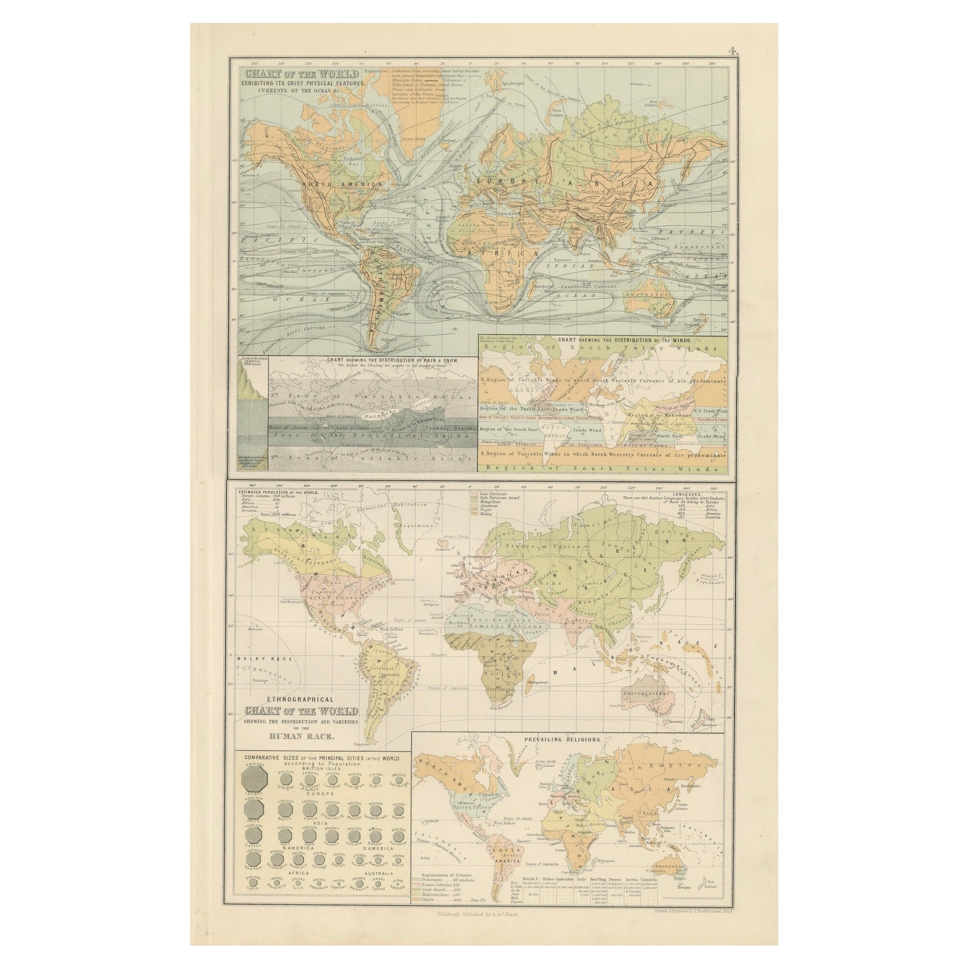
Carta geografica antica del mondo - Caratteristiche fisiche e mappa etnografica, 1884
Carta geografica antica del mondo - Caratteristiche fisiche e mappa etnografica, 1884
Descrizione:
Questa affascinante doppia lastra tratta dalla New and Revised Edition of Black's ...
Categoria
Di antiquariato/d’epoca, Anni 1880, Scozzese, Mappe
Materiali
Carta
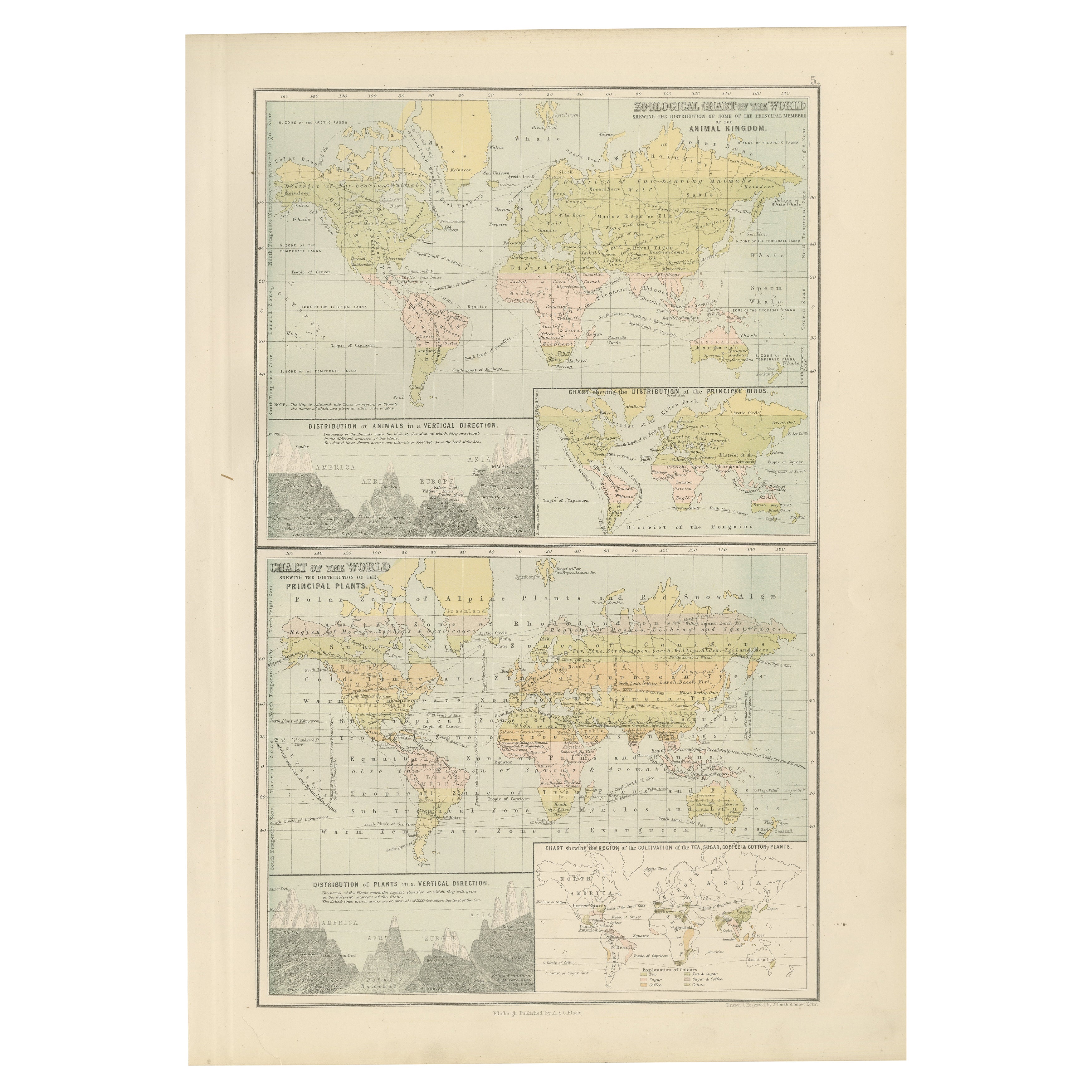
Antica carta zoologica e botanica del mondo - Mappa decorativa, 1884
Antiche carte zoologiche e botaniche del mondo - Atlante di Black, 1884
Questa doppia lastra tratta dalla New and Revised Edition of Black's General Atlas of the World, pubblicata a...
Categoria
Di antiquariato/d’epoca, Anni 1880, Scozzese, Mappe
Materiali
Carta
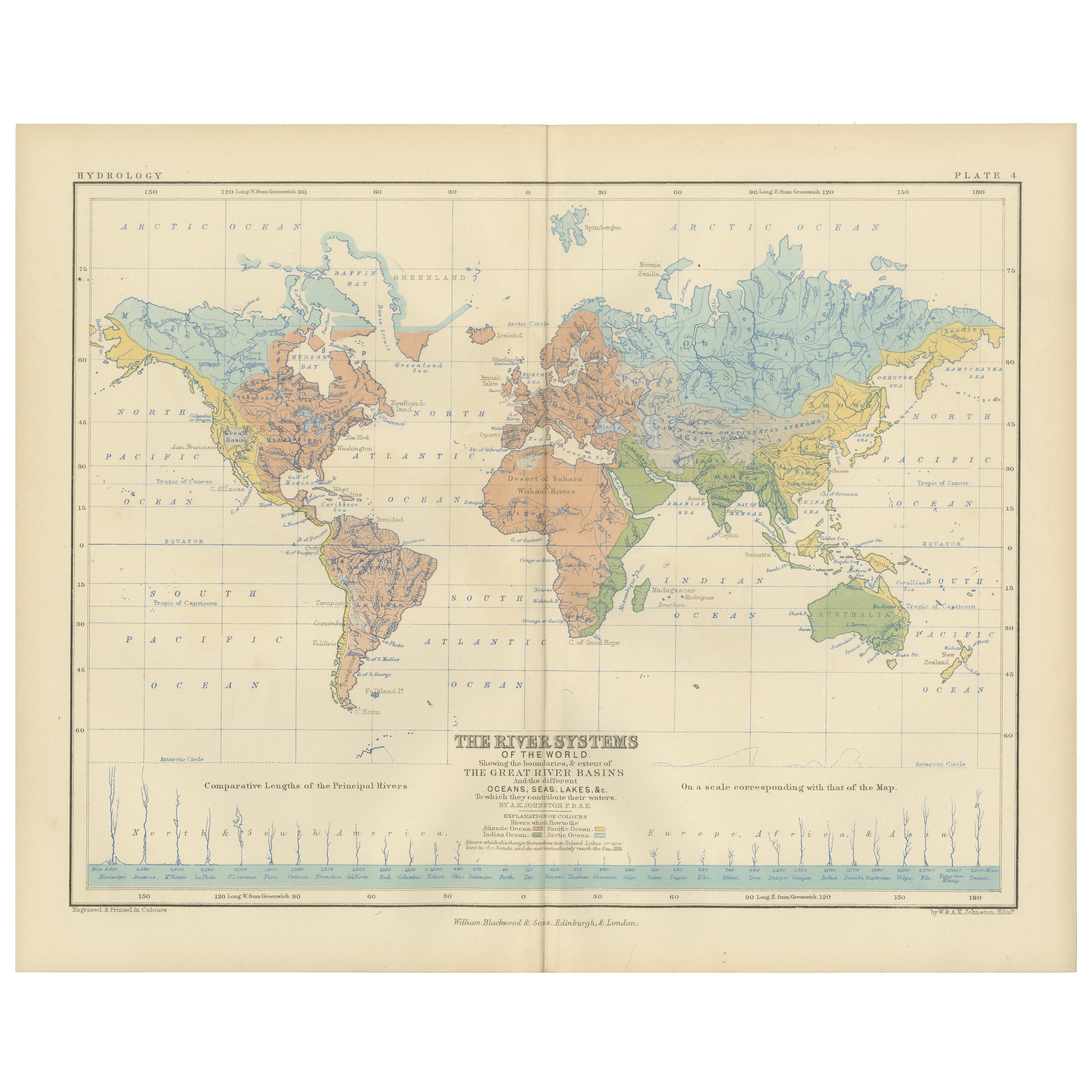
River Systems Map of the World by A.K. Johnston – Educational Print 1852
River Systems Map of the World by A.K. Johnston – Educational Print 1852
This striking 1852 map titled "The River Systems of the World" was created by the noted Scottish geographer ...
Categoria
Di antiquariato/d’epoca, Metà XIX secolo, Scozzese, Stampe
Materiali
Carta

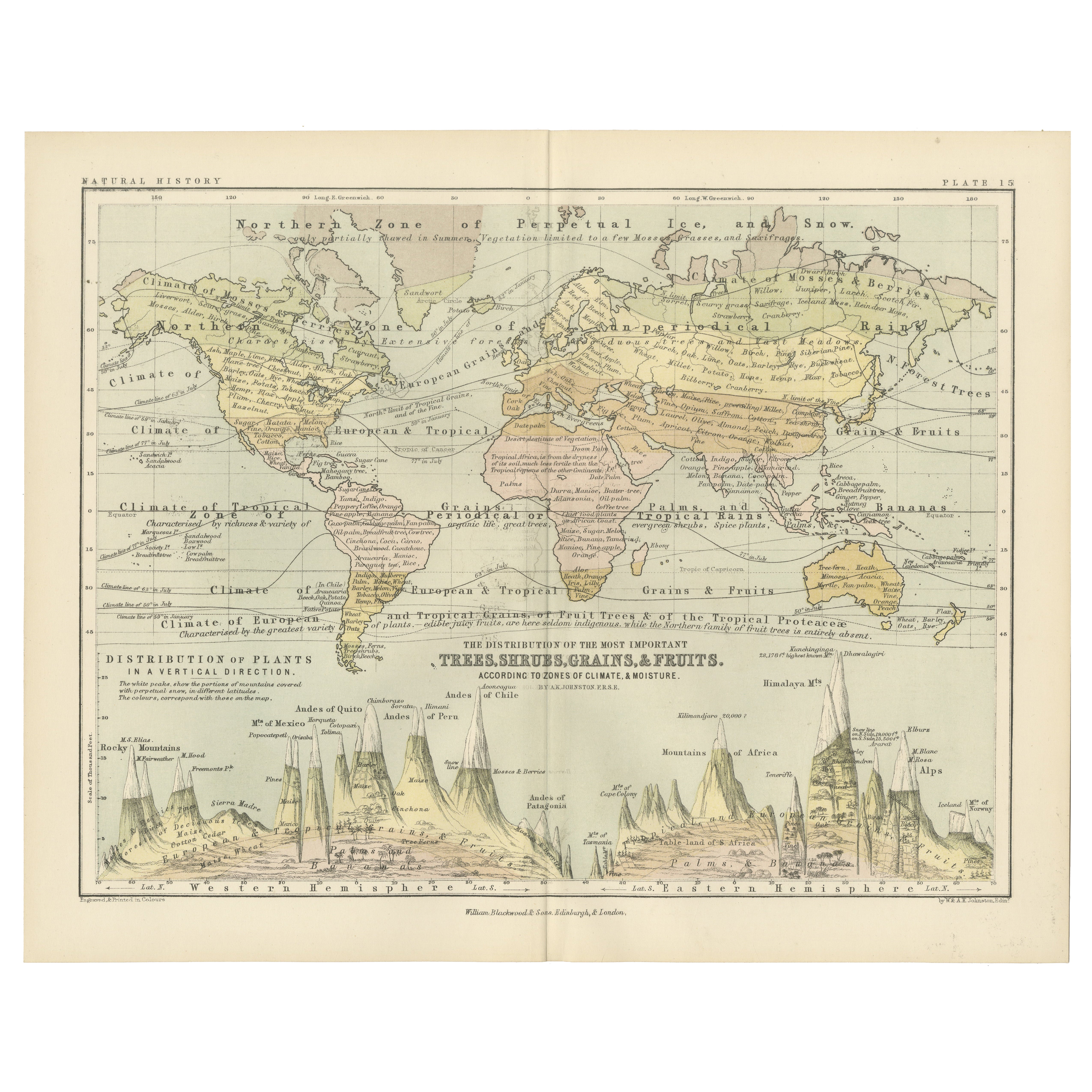
Botanical Map by A.K. Johnston – Global Plant Distribution Chart 1852
Botanical Map by A.K. Johnston – Global Plant Distribution Chart 1852
This remarkable antique chart titled "The Distribution of the Most Important Trees, Shrubs, Grains, & Fruits Ac...
Categoria
Di antiquariato/d’epoca, Metà XIX secolo, Scozzese, Stampe
Materiali
Carta
Ti potrebbe interessare anche
Mappa antica originale del mondo di Dower, 1835 circa
Bella mappa del mondo
Disegnato e inciso da J.Dower
Pubblicato da Orr & Smith. C.1835
Senza cornice.
Spedizione gratuita
Categoria
Di antiquariato/d’epoca, Anni 1830, Inglese, Mappe
Materiali
Carta

Mappa dell'Impero Britannico - Mappa antica di Karl Spruner - 1760 ca.
Di Karl Spruner von Merz
La Mappa dell'Impero Britannico è un'opera d'arte realizzata intorno al 1760 da Karl Spruner.
Stampa originale colorata a mano.
Buone condizioni, a parte l'ingiallimento della cart...
Categoria
Anni 1760, Moderno, Stampe figurative
Materiali
Acquaforte

210 € Prezzo promozionale
25% in meno
Grande mappa antica originale del mondo, Fullarton, 1870 ca.
Grande mappa del mondo. Mostra entrambi gli emisferi
Dal celebre Atlante Reale Illustrato
Litografia. Colore originale.
Pubblicato da Fullarton, Edimburgo, 1870 ca.
Senza cornic...
Categoria
Di antiquariato/d’epoca, Anni 1870, Scozzese, Mappe
Materiali
Carta

1864 Planisfero originale illustrato - Mappa del mondo - Geografia
Immergiti nell'epico viaggio del passato con il Planisfero Storico Illustrato del 1864 di Charpentier! 🗺️ Questo tesoro cartografico ti trasporta attraverso le complessità della sto...
Categoria
Anni 1860, Stampe e riproduzioni
Materiali
Lino, Litografia, Carta

1864 Mappa del mondo di Johnson sulla proiezione di Mercatore, Ric.B009
Una mappa di Johnson del 1864 di
il mondo sulla proiezione di Mercatore
Ric.b009
A proposito di questo articolo
"Questa mappa antica proviene dal Johnson's New Illustrated...
Categoria
Di antiquariato/d’epoca, XIX secolo, Olandese, Mappe
Materiali
Carta

Mappa antica originale dell'emisfero orientale di Dower, 1835 circa
Bella mappa dell'emisfero orientale
Disegnato e inciso da J.Dower
Pubblicato da Orr & Smith. C.1835
Senza cornice.
Spedizione gratuita
Categoria
Di antiquariato/d’epoca, Anni 1830, Inglese, Mappe
Materiali
Carta
