Items Similar to Ireland
Want more images or videos?
Request additional images or videos from the seller
1 of 2
John SenexIreland1712
1712
About the Item
Ireland
SENEX, John.
Ireland Corrected from the Latest Observations Divided into its Provinces, Counties and Baronies. Shewing the Principal Roads, and the Distances of Places, in Common reputed Miles. by Inspection Where Barracks are Erected &c. By John Senex F.R.S.
John Senex F.R.S., the Globe against St Dunstans Church, Fleetstreet, London 1712 [-1728].
John Senex (1678-1740) was one of the foremost mapmakers in England in the early eighteenth century. He was also a surveyor, globemaker, and geographer. As a young man, he was apprenticed to Robert Clavell, a bookseller. He worked with several mapmakers over the course of his career, including Jeremiah Seller and Charles Price. In 1728, Senex was elected as a Fellow of the Royal Society, a rarity for mapmakers. The Fellowship reflects his career-long association as engraver to the Society and publisher of maps by Edmund Halley, among other luminaries. He is best known for his English Atlas (1714), which remained in print until the 1760s. After his death in 1740 his widow, Mary, carried on the business until 1755. Thereafter, his stock was acquired by William Herbert and Robert Sayer (maps) and James Ferguson (globes).
Double-page engraved map on 2 sheets joined, with full contemporary hand-colouring. Inset map of the British Isles, decorative title cartouche surmounted by a harp with a crown above, key table and scale bars. Left margin trimmed to neat line, some light creasing at edges with a couple of tiny marginal tears, otherwise good. Size: 665 mm by 960 mm, sheet size: 680 by 990 mm.
Framed and glazed, overall size: 107cm by 77.3cm by 2cm.
- Creator:
- Creation Year:1712
- Dimensions:Height: 42.13 in (107 cm)Width: 30.32 in (77 cm)Depth: 0.79 in (2 cm)
- Medium:
- Period:1710-1719
- Condition:
- Gallery Location:London, GB
- Reference Number:
About the Seller
5.0
Vetted Seller
These experienced sellers undergo a comprehensive evaluation by our team of in-house experts.
Established in 1979
1stDibs seller since 2020
11 sales on 1stDibs
Typical response time: 3 hours
- ShippingRetrieving quote...Ships From: London, United Kingdom
- Return PolicyA return for this item may be initiated within 14 days of delivery.
More From This SellerView All
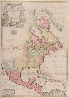
- one of the earliest large-scale English maps of North AmericaBy John SenexLocated in London, GBone of the earliest large-scale English maps of North America SENEX, John. North America Corrected from the Observations Communicated to the Royal Society at London, and the Royal Academy at Paris. By John Senex F.R.S. 1710. To the Honorable Anthony Hammond Esq. One of the Comissioners of Her Maj[es]ties Navy. This Map his humbly Dedicated and Presented by his Obliged Servants. John Senex F.R.S., 1710 [-1728]. A fine map of North and Central America, with the West Indies. One of the earliest large-scale English maps of North America. It represents a British attempt to consolidate new information about the region and borrows data from such recently published sources as Delisle’s landmark Carte du Mexique et de la Floride and Carte de la Canada. Senex improves upon De L'Isle's work with a fine depiction of the Great Lakes region and the most accurate definition of the lower Mississippi River and its delta by an English cartographer of the period. Several of the most important and controversial cartographic discoveries of the period are discussed at length, including Lahontan’s mythical Long River and the Salt Lake east of the Country of the Mozeemleck’s, both of which are also depicted in remarkable (albeit fanciful) detail. Sir William Phipps discovery of Spanish wrecks off the coast of the Caicos and Southern Bahamas is also noted. Senex also extended the map’s coverage to the Canadian Arctic and the Terra Incognita above Baffin’s Bay. Present-day Oklahoma and Texas are part of La Floride, considered at the time to be a possession of the French. The Red River and the Indian villages of East Texas are portrayed accurately, but Senex, following Delisle, incorrectly placed many Texas rivers...Category
1710s Naturalistic More Art
MaterialsWatercolor, Engraving
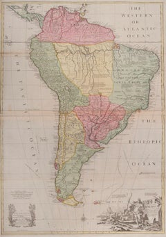
- South AmericaBy John SenexLocated in London, GBSouth America SENEX, John. South America Corrected from the Observations Communicated to the Royal Society’s of London & Paris. By John Senex. To Edmund Halley. LLD. Savilian Professor of Geometry in Oxford and Fellow of the Royal Society. This Map corrected from His own Discoveries In gratefull Acknowledgement of his Ready assistance to Encourage this Designe is Humbly Dedicated. John Senex, at the Globe against St Dunstans Church, Fleetstreet, London 1710 [-1728]. John Senex (1678-1740) was one of the foremost mapmakers in England in the early eighteenth century. He was also a surveyor, globemaker, and geographer. As a young man, he was apprenticed to Robert Clavell, a bookseller. He worked with several mapmakers over the course of his career, including Jeremiah Seller and Charles...Category
1710s Naturalistic More Art
MaterialsWatercolor, Engraving
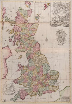
- Great BritainBy John SenexLocated in London, GBGreat Britain SENEX, John. A New Map of Great Britain Corrected from the Observations communicated to the Royal Society at London. By John Senex F.R.S. To the Right Hono[ra]ble William Connelly ESQ. One of the Commissioners of His Maj[es]ties Revenue, Speakerof the Hono[a]ble House of Commons, and one of His Maj[es]ties most Hono[ra]ble Privy Council for Ye Kingdom of Ireland. This Map is dedicated by John Senex. John Senex F.R.S. 1710 [-1728]. John Senex (1678-1740) was one of the foremost mapmakers in England in the early eighteenth century. He was also a surveyor, globemaker, and geographer. As a young man, he was apprenticed to Robert Clavell, a bookseller. He worked with several mapmakers over the course of his career, including Jeremiah Seller and Charles Price...Category
1710s Naturalistic More Art
MaterialsWatercolor, Engraving
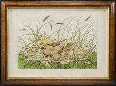
- A Group of Four engraved and hand-coloured Birds Nests.By Cornelis Nozeman and Jan Christiaan SeppLocated in London, GBNOZEMAN, Cornelius and Jan Christian SEPP. A Group of Four Birds Nests: NIDUS ARDEAE, Nycticoracis; NIDUS PLATALEA, Leucorodia; NIDUS ARDEAE STELLARIS and NIDUS PELECANI, Carbonis f...Category
1770s Naturalistic Animal Prints
MaterialsEngraving, Watercolor
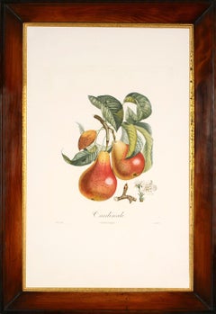
- A Group of Six Pears.By Pierre Jean François TurpinLocated in London, GBPOITEAU, A. and P. TURPIN. Traité des arbres fruitiers: A Group of six Pears. H. Perronneau for T. Delachausée, Paris, 1807-1835. A group of six stipple-engraved plates printed in c...Category
Early 1800s Naturalistic Still-life Prints
MaterialsEngraving
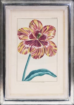
- BUCHOZ. A Group of Four TulipsLocated in London, GBA Group of 4 hand-coloured engraved plates of tulips, in matching silver leaf frames. Dimensions: 34.6cm by 48.5cm. A fine group of these rare flower plates, the complete volume of 40 being part of Le Jardin d'Eden, which was intended as the supplement to the Collection des Fleurs de la Chine & de l'Europe, first published in 1776. [Paris 1781] The second half of the eighteenth century saw a boom in natural history publications in France fuelled by such works as Buffon’s Histoire Naturelle. The accession of Louis XVI in 1774 was followed by a relaxation in the regulation of the book trade making it easier for authors to publish their own works. No other writer was to take such copious advantage of these two developments as Pierre-Joseph Buchoz (1731-1807), a French physician, lawyer and naturalist. His works are characterised by the beauty of the illustrations, and their rarity owing to the small size of the print runs. The final tulip plate...Category
1780s Naturalistic Still-life Prints
MaterialsPaper, Engraving
You May Also Like
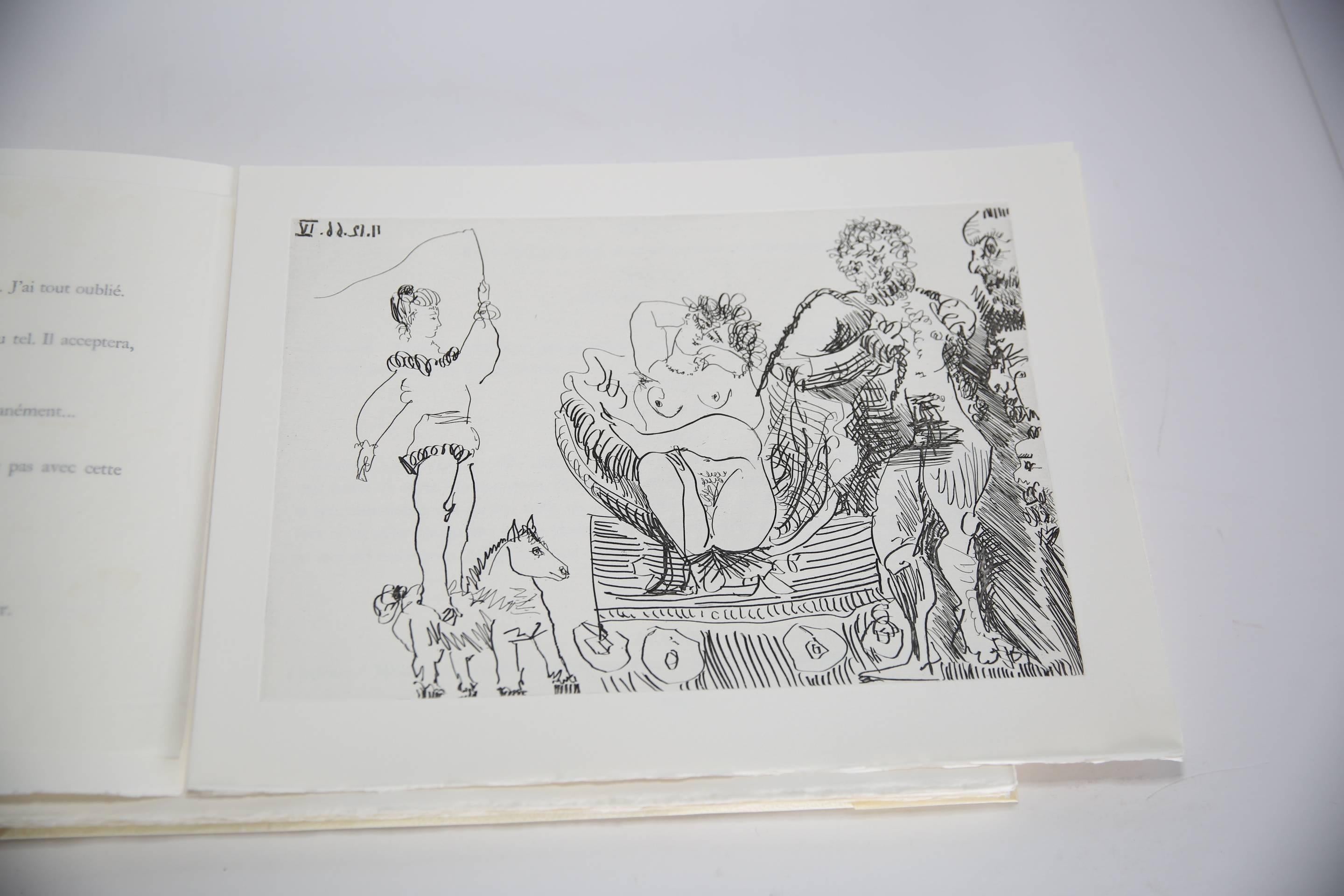
- Le Cocu Magnifique -- complete illustrated book with 12 original etchingsBy Pablo PicassoLocated in New York, NYAbout In-folio Oblong Dimensions : 29x39 cm. Paris Atelier Crommelynck 1968 Edition #41 of 200 copies including 12 original out-of-text etchings (7 etchings, 4 etchings and aquatint...Category
Mid-20th Century Modern Figurative Prints
MaterialsDrypoint, Etching, Aquatint
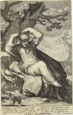
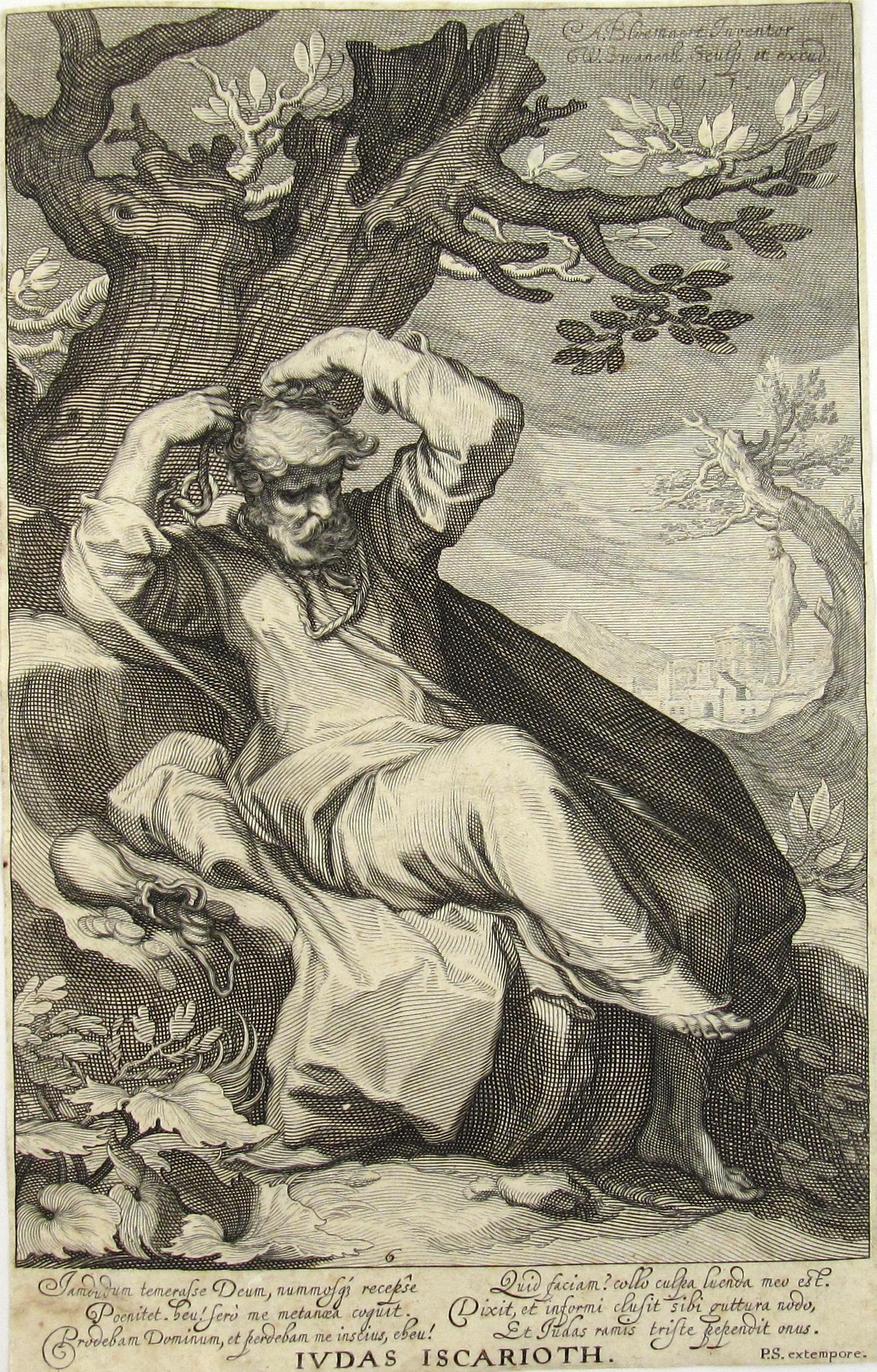
- Judas Iscarioth after Abraham Bloemaert (1564/66-1651), orig. published in 1611Located in Meinisberg, CHJudas Iscarioth - Judas hangs himself Engraved and published by Willem van Swanenburg (Dutch, 1580 - 1612) after designs by Abraham Bloemaert (1564...Category
1610s Realist Figurative Prints
MaterialsInk, Laid Paper, Engraving
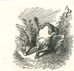
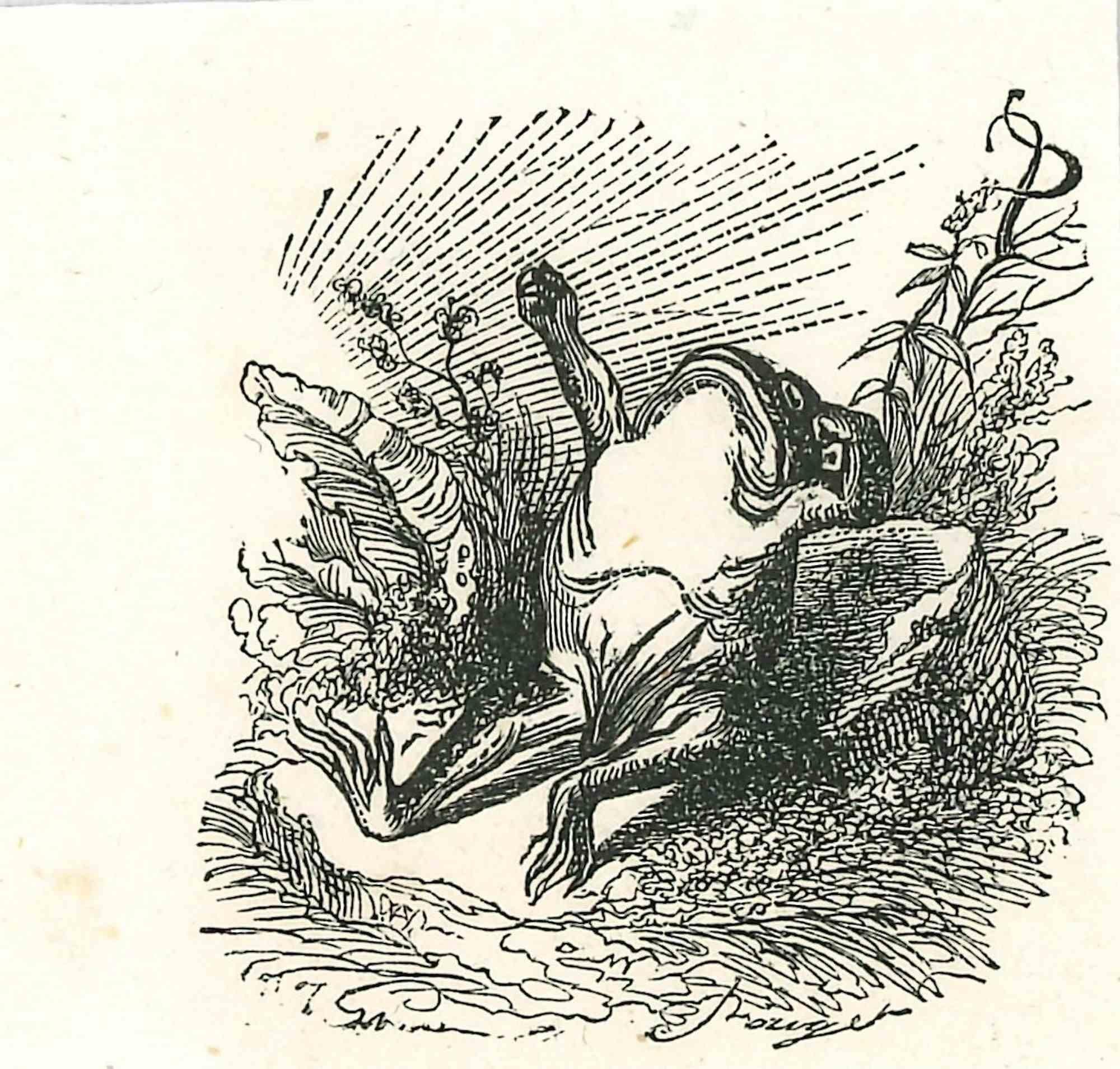
- The Lazy Frog - Original Lithograph by J.J Grandville - 1852By Jean Jeacques GrandvilleLocated in Roma, ITThe Lazy Frog is an original lithograph by J.J. Grandville from "Scènes de la vie privée et publique des animaux, 1852. Published by Manesq & Harvard, Paris. Good Conditions but ag...Category
1850s Modern More Art
MaterialsPaper, Engraving
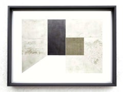
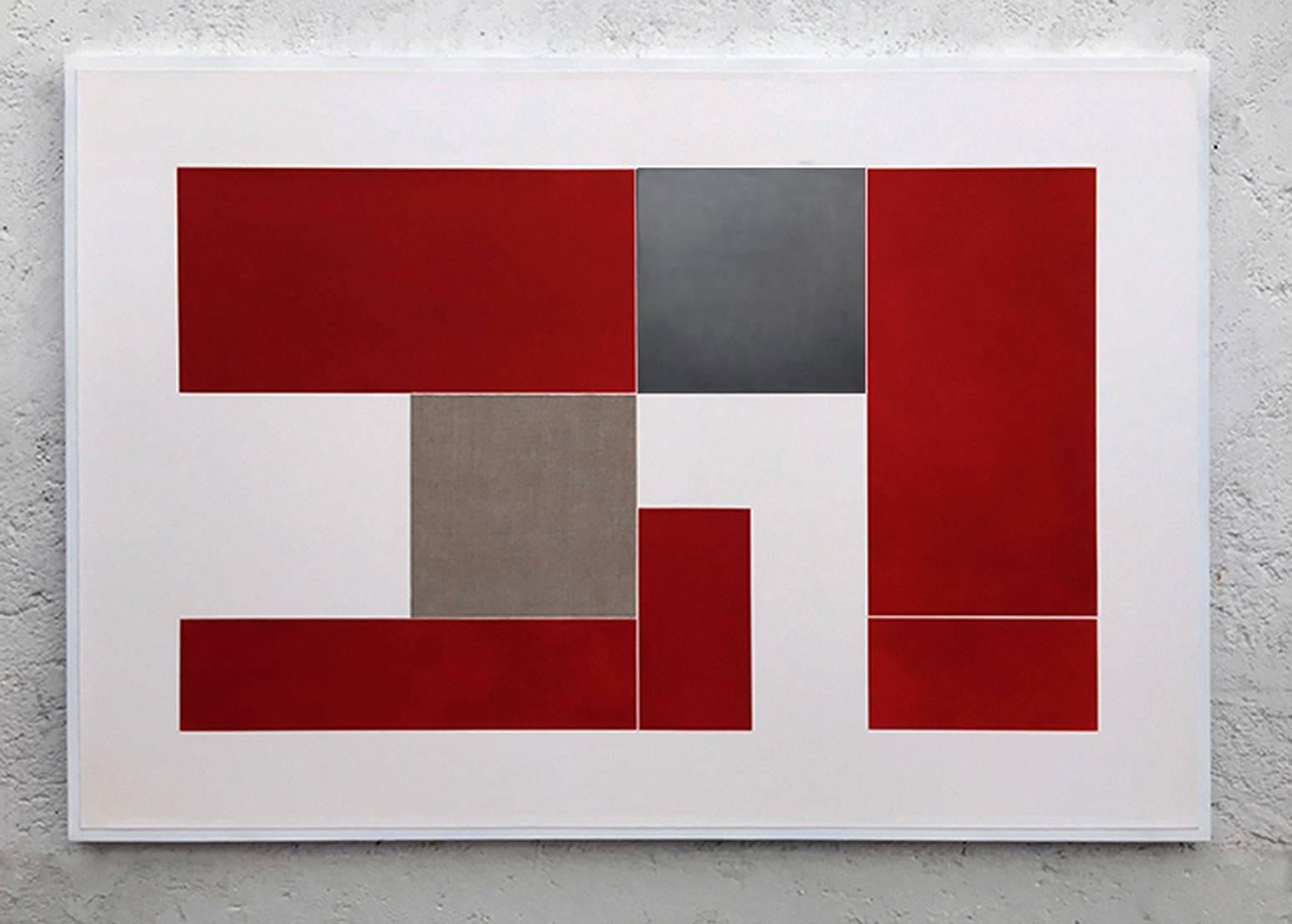
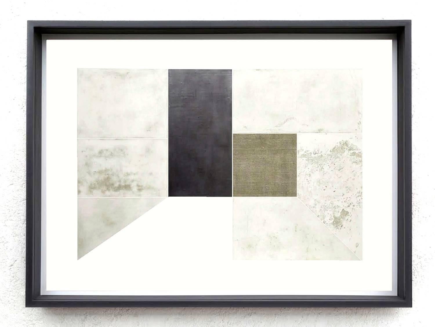
- Red RoomBy Alberto Montaño MasonLocated in Cuernavaca, MorelosEtching with lead and lined collage on cotton paperCategory
2010s Abstract Geometric Abstract Prints
MaterialsEngraving
- White RoomBy Alberto Montaño MasonLocated in Cuernavaca, MorelosEtching with lead and lined collage on cotton paperCategory
2010s Abstract Geometric Abstract Prints
MaterialsEngraving
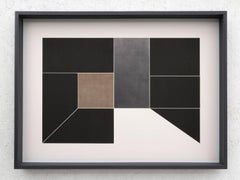
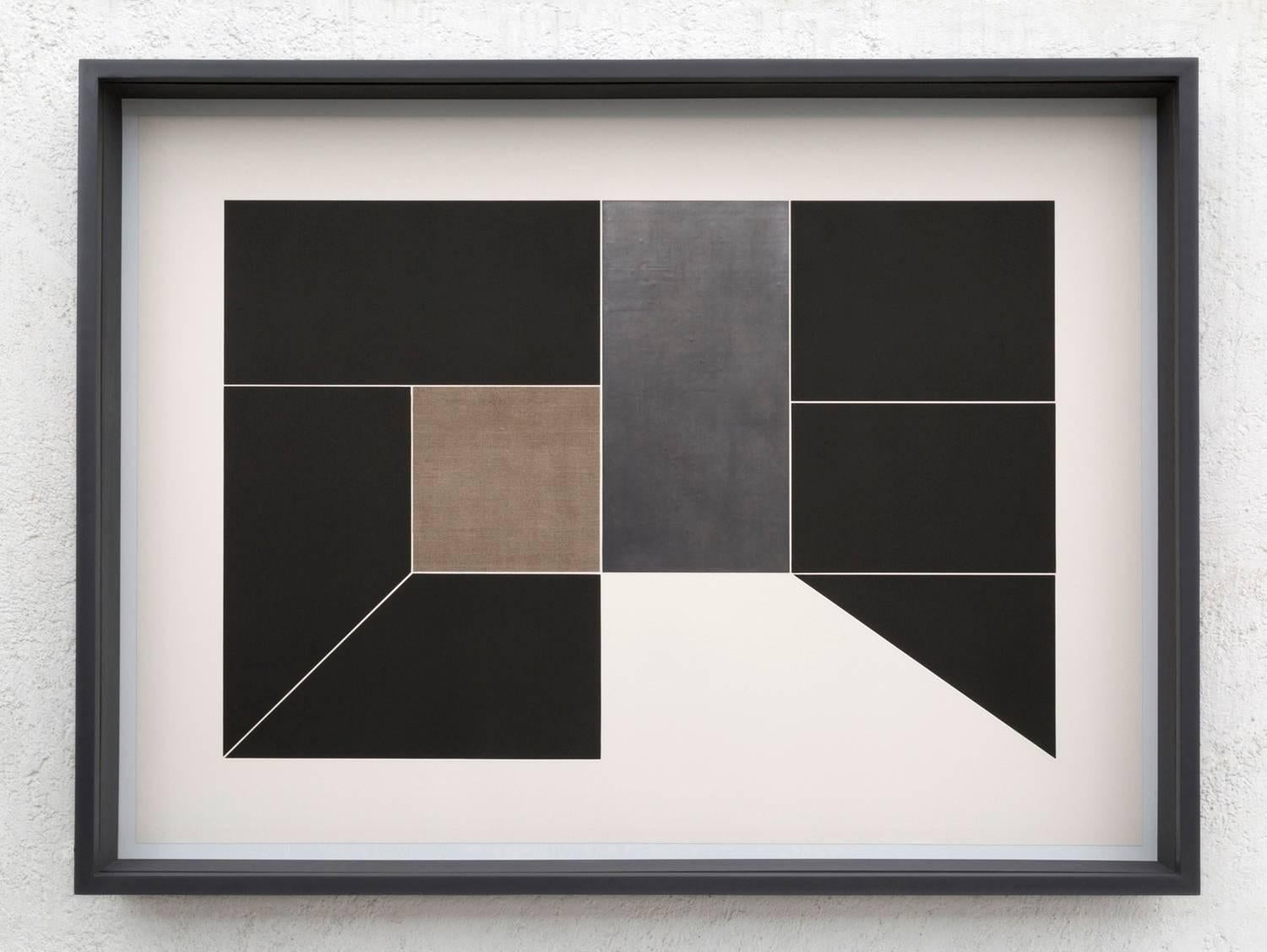
- Black RoomBy Alberto Montaño MasonLocated in Cuernavaca, MorelosEtching with lead and lined collage on cotton paperCategory
2010s Abstract Geometric Abstract Prints
MaterialsEngraving