Items Similar to North America: A Framed Hand-colored 19th Century German Map by Adolph Stieler

Want more images or videos?
Request additional images or videos from the seller
1 of 13
Adolf StielerNorth America: A Framed Hand-colored 19th Century German Map by Adolph Stieler1832
1832
About the Item
This framed early 19th century map of North America entitled "Nord-Amerika" is plate No. LIV (No. 46) from Adolph Stieler's Hand-Atlas, published in Gotha, Germany by Justus Perthes in 1832. The original title of the publication was 'Hand-Atlas über alle Theile der Erde und über das Weltgebäude' (Handy Atlas of all Parts of the World and of the Universe).
The map depicts eastern portions of Russia and the adjacent Aleutian Islands and Alaska which are identified as Russian territories. California, Arizona, New Mexico and much of Texas are still part of Mexico. The "Oregon District" includes the modern day state of Washington. Much of the central portions of the United States are identified as Native American regions such as The Sioux District, The Mandan District, The Ozark District, The Huron District and The Osage District. The map does include Canada, Mexico, Central America, Cuba, Jamaica, Haiti, Santa Domingo (the Dominican Republic) , the West Indies and portions of Greenland and South America. Along the California coast, Mendocino, Monterrey, Santa Barbara, San Diego, Santa Catalina Island are identified, San Francisco and Los Angeles were not included.
The map is hand-colored in outline. It is presented in a light brown distressed bleached wood frame with a cream-colored mat. The frame measures 19.5" high x 22" wide x 0.88" deep. There is a central vertical fold, as issued. The map is in very good condition. The mat is somewhat toned.
There are two other 19th century maps of North America (the United States and one including Mexico) listed on 1stdibs that are presented in identical style frames and mats. They can be seen by entering their reference #'s (LU5206222080792 or LULU5206221574182) in the search field. These would make an interesting and attractive grouping. A discount is available for purchase of a grouping of two or three of these maps.
Adolf Stieler (1775-1836) was a German cartographer and lawyer. He was the main cartographer in Justus Perthes' Geographical Institute in Gotha, Germany. He served in the German government for his entire career, but maintained an interest in cartography and published many prominent works, including his Hand-Atlas, which was the leading German world atlas until the middle of the 20th century.
- Creator:Adolf Stieler (1775 - 1836, German)
- Creation Year:1832
- Dimensions:Height: 19.5 in (49.53 cm)Width: 22 in (55.88 cm)Depth: 0.88 in (2.24 cm)
- Medium:
- Period:
- Condition:
- Gallery Location:Alamo, CA
- Reference Number:
About the Seller
5.0
Vetted Seller
These experienced sellers undergo a comprehensive evaluation by our team of in-house experts.
Established in 2011
1stDibs seller since 2019
233 sales on 1stDibs
Typical response time: 1 hour
- ShippingRetrieving quote...Ships From: Alamo, CA
- Return PolicyA return for this item may be initiated within 7 days of delivery.
More From This SellerView All
- Cartusia Bruxellensis Monastery in Brussels: A 17th C. Hand-colored EngravingBy Lucas Vorsterman the YoungerLocated in Alamo, CAThis is a 17th century hand-colored copperplate engraving entitled "Cartusia Bruxellensis" by Lucas Vorsterman, the Younger, after a drawing by Jacob van Werden or Jacques van Weerden, published in 1659 in Antonius Sanderus' book 'Chorographia sacra Brabantiae sive celebrium aliquot in ea provincia ecclesiarum et coenobiorum descriptio . . . Brussel' (A sacred chorography of Brabant, or a description of several famous churches and convents in that province). It also appeared in other publications by Sanderus. In the 17th century, Brussels was within the Duchy of Brabant. This engraving depicts a bird's-eye view of the Scheut Carthusian Monastery in Brussels. Scheut is a district of Anderlecht, a municipality of Brussels, Belgium. The monastery housed monks, who took a vow of silence, in 20 rooms. There is a central courtyard with trees and shrubs. Monks are depicted strolling along its pathways. The cells for the friars are in the middle the cloister. There are people along the streets in the foreground and to the right of the large, imposing monastery. Some are on horseback, others are walking. In the lower right, what appears to be a dog pulls a small cart containing barrels, possibly of beer or wine. Districts and neighborhoods are labelled in the background, including Scheut, Anderlecht and Ransfort. A very ornate cartouche in the lower left contains Latin and the artist's attribution. Another decorative cartouche in the upper central area contains the title. This beautifully hand-colored and detailed engraving is printed on laid, chain-linked paper with wide, full margins. The sheet measures 17.25" high and 21.25" wide. It has Latin text on the verso. It has a central vertical fold, as issued, which is reinforced on the verso. Two small spots in the lower margin may actually represent drops of watercolor paint used to color the engraving. It is otherwise in very good condition. Antonius Sanderus (1586-1664) was a Flemish Catholic cleric and historian. He was born "Antoon Sanders", but Latinized his name like many writers and scholars of his time. He was the author of several books, including 'Chorographia Sacra Brabantiae', which was illustrated with this engraving. Lucas Vorsterman the Younger (1624-between 1666 & 1676) was a Flemish Baroque engraver and draughtsman. He produced engravings after the work of contemporary painters and for books by Antwerp publishers. Jacob van Werden or Jacques van Weerden (active 1643-1669), was a Flemish draughtsman, cartographer, military engineer and archer who was active in the Habsburg Netherlands. His drawings were used as designs for prints executed by various printmakers. He worked on maps, topographical views, historical scenes, portraits and book illustrations. He had a career as a military engineer and a member of the guard of the Spanish King. He advised on various military engineering projects and was an engineer of the Spanish army...Category
Mid-17th Century Old Masters Landscape Prints
MaterialsEngraving
- Bermuda: An Early 17th Century Hand-colored Map by Henricus HondiusBy Henricus HondiusLocated in Alamo, CAThis attractive and interesting map of Bermuda by Henricus Hondius in 1633 is entitled "Mappa Aestivarum Insularum, Alias Barmudas". It is based on a ...Category
Early 17th Century Old Masters Landscape Prints
MaterialsEngraving
- L'Isle de France: A Hand-colored 17th Century Map by De WitBy Frederick de WitLocated in Alamo, CAThis colorful and detailed 17th century hand-colored copperplate map by Frederick De Wit was published in Amsterdam between 1666 and 1760. The map depicts the Île-de-France, which is one of the ancient provinces of France. Paris is located in the center of the map, with Versailles to the southwest The map extends from Rouen in the west to Reims in the east. The area around Paris, the Véxin Français, was the original domain of the king of France. Other areas were ruled by French feudal lords. For example, the Véxin Normand area was the domain of the Duke of Normandy...Category
Early 18th Century Old Masters More Prints
MaterialsEngraving
- Ulysses Deriding Polyphemus: A Framed 19th C. Engraving After J. M. W. TurnerBy J.M.W. TurnerLocated in Alamo, CAThis beautiful 19th century framed hand-colored engraving/etching entitled "Ullyses Deriding Polyphemus" by Edward Goodall is based on an original 1829 painting by the renowned Briti...Category
Mid-19th Century Romantic Landscape Prints
MaterialsEngraving, Etching
- View of Emden, Germany: A 16th Century Hand-colored Map by Braun & HogenbergBy Franz HogenbergLocated in Alamo, CAThis is a 16th century original hand-colored copperplate engraved map of a bird's-eye View of Embden, Germany entitled " Emuda, vulgo Embden vrbs Frisia orientalis primaria" by Georg Braun & Franz Hogenberg, in volume II of their famous city atlas "Civitates Orbis Terrarum", published in Cologne, Germany in 1575. This is a beautifully colored and detailed map of Emden, a seaport in northwestern Germany, along the Ems River and perhaps portions of over Dollart Bay, near the border with the Netherland. The map depicts a bird's-eye view of the city from the southwest, as well as a view of the harbor and an extensive system of canals. Numerous ships of various sizes, as well as two rowboats containing numerous occupants are seen in the main waterway in the foreground and additional boats line two canals in the center of the city. Two men and two women are shown on a hill in the foreground on the right, dressed in the 16th century style of nobility. Two ornate crests are included in each corner. A title strap-work cartouche is in the upper center with the title in Latin. The crest on the right including Engelke up de Muer (The Little Angel on the Wall) was granted by Emperor Maximilian I in 1495. This is an English translation of an excerpt of Braun's description of Embden: "In Emden, the capital of East Frisia, rich merchants live in very fine houses. The city has a broad and well-situated harbour, which in my opinion is unique in Holland. Frisia and the whole of the Netherlands, for the ships can anchor here right under the city walls. They have also extended the harbour as far as the New Town, so that up to 400 ships can now find shelter here when the sea is rough." The emphasis on the harbor and waterways within the city highlights the importance of Emden's place as a seaport at this time. Embden developed from a Dutch/Flemish trading settlement in the 7th-8th centuries into a city as late as late 14th century. In 1494 it was granted staple rights, and in 1536 the harbour was extended. In the mid-16th century Emden's port was thought to have the most ships in Europe. Its population then was about 5,000, rising to 15,000 by the end of the 16th century. The Ems River flowed directly under the city walls, but its course was changed in the 17th century by the construction of a canal. Emden has canals within its city limits, a typical feature of Dutch towns, which also enabled the extension of the harbor. In 1744 Emden was annexed by Prussia and is now part of Germany. It was captured by French forces in 1757 during the Seven Years' War, but recaptured by Anglo-German forces in 1758. During the Napoleonic French era, Emden and the surrounding lands of East Frisia were part of the short-lived Kingdom of Holland. References:Van der Krogt 4, 1230, State 2; Taschen, Braun and Hogenberg...Category
16th Century Old Masters Landscape Prints
MaterialsEngraving
- Ireland: A Framed 17th Century Hand-colored Map by Jan JannsonBy Johannes JanssoniusLocated in Alamo, CAThis is a 17th century hand-colored map entitled "Hibernia Regnum Vulgo Ireland" by Johannes Janssonius's (Jan Jansson), published in Amsterdam in 1640. This highly detailed map depicts the Emerald Isle with an extensive display of towns, roads, mountains, rivers, lakes and county borders, etc. It includes two decorative cartouches on the left. The title cartouche includes the Irish harp and the second, in the upper left, includes a lion wearing a crown on the left, a unicorn on the right and a coat-of-arms in the middle, which includes another Irish harp. A distance scale is seen in the lower right, augmented with two putti. The map is embellished with three sailing ships and a sea monster. Western portions of Scotland and England...Category
Mid-17th Century Old Masters Landscape Prints
MaterialsEngraving


You May Also Like
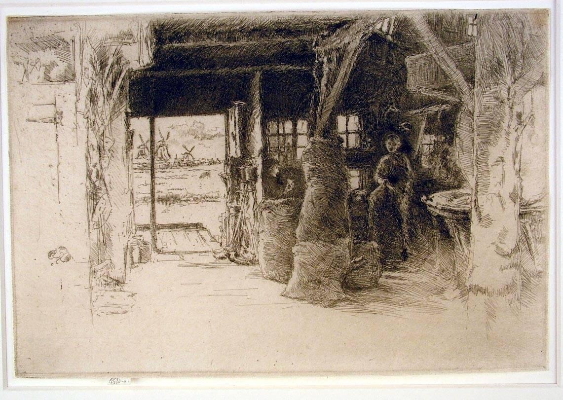
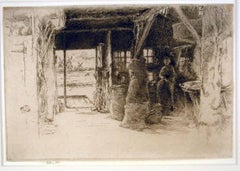
- The Mill, Amsterdam, 1889By James Abbott McNeill WhistlerLocated in New York, NYJames Whistler (1834-1903), The Mill, 1889, etching and drypoint, signed in pencil with the butterfly on the tab and inscribed “imp”, and inscribed “first state” (twice) and annotated “Wunderlich” and signed again with the butterfly verso. Reference: Kennedy 413, first state (of 5). Glasgow 457, second state (of 6; see discussion below) (cf. Margaret F. MacDonald, Grischka Petri, Meg Hausberg, and Joanna Meacock, James McNeill Whistler: The Etchings, a catalogue raisonné, University of Glasgow, 2011) On laid paper, in very good condition, trimmed just outside of the platemark all around except for the tab by the artist, 6 1/4 x 9 3/8 inches. A very fine impression of this great rarity, printed in black/brown ink with a slight veil of plate tone. provenance: H. Wunderlich & Co., New York Louis B. Dailey, New York (Lugt 4500) sale, Sotheby’s, New York, October 31, 2003, lot 69 literature; Neue Lagerliste 122: James McNeill Whistler – Etchings...Category
1880s Impressionist Landscape Prints
MaterialsDrypoint, Etching
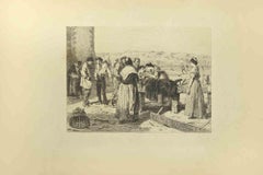
- The Nursing - Etching by Eugène Burnand - Late 19th centuryLocated in Roma, ITNursing is an etching realized by Eugène Burnand (1850-1921) in the Late 19th century. Good conditions with foxing. The artwork is realized through s...Category
Late 19th Century Modern Figurative Prints
MaterialsEtching, Engraving
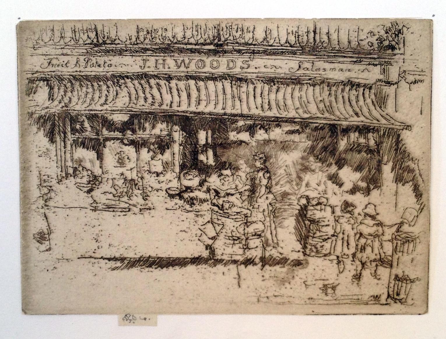
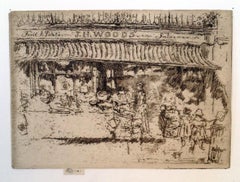
- J.H. Woods’ Fruit Shop, ChelseaBy James Abbott McNeill WhistlerLocated in New York, NYJames Whistler (1834-1903), J.H. Woods’ Fruit Shop, Chelsea, etching and drypoint, 1887-88. Signed with the butterfly on the tab and annotated “imp,” also signed with the butterfly in pencil verso and numbered “1”. References: Kennedy 265 second state (of 2), Glasgow 327 second state (of 4). Trimmed by the artist around the plate mark except for the tab, in excellent condition. Printed in black ink on ivory laid paper, 3 3/4 x 5 1/8 inches. A fine impression of this great rarity; the print was never published. Glasgow accounts for four impressions. watermark: partial arms of Amsterdam(cf. Spink/Stratis/Tedeschi, watermark nos. 12ff.) This is before the third state in which heavy shading was added around the woman at the center, and the heads of figures at right and left of the figure are defined. In Glasgow’s fourth state the shading and the figure were removed; no impression is known of this state, but the state is inferred from the cancelled plate. According to Glasgow “Joseph Henry Wood had a greengrocer’s shop at 1 Park Walk...Category
1880s Impressionist Landscape Prints
MaterialsEtching, Drypoint
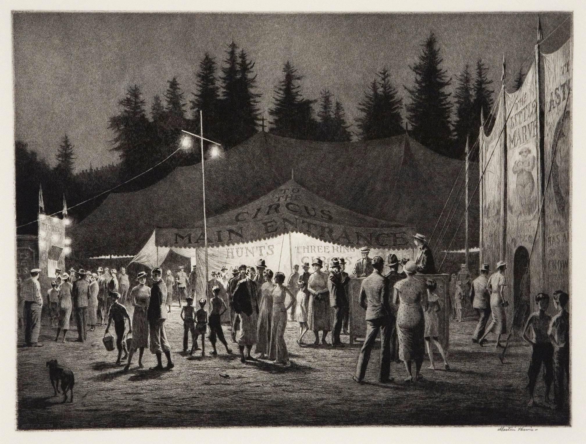
- Circus Night.By Martin LewisLocated in New York, NYSigned in pencil by the artist. Drypoint and sandground, 1933. Edition 100, recorded impressions 43. Of the forty-three recorded impressions printed, a group of those were unsigne...Category
1930s Realist Landscape Prints
MaterialsDrypoint
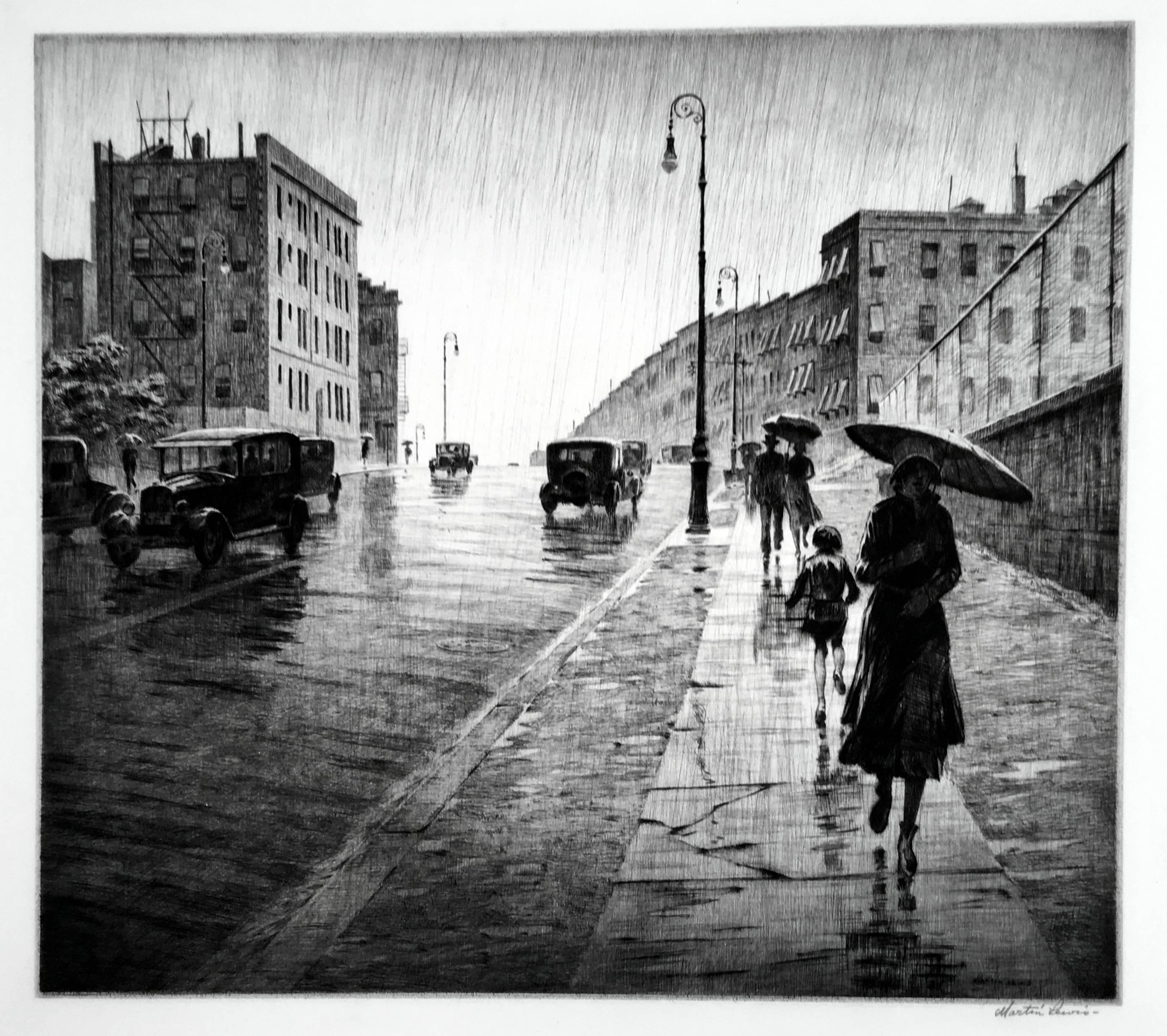
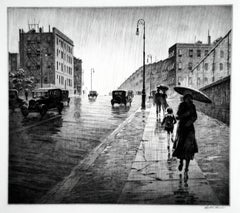
- Rainy Day, QueensBy Martin LewisLocated in New York, NYMartin Lewis (1881-1962), Rainy Day, Queens, drypoint, 1931, signed in pencil lower right [also signed in the plate lower right]. Reference: McCarron 94, only state, from the edition...Category
1930s American Realist Landscape Prints
MaterialsDrypoint
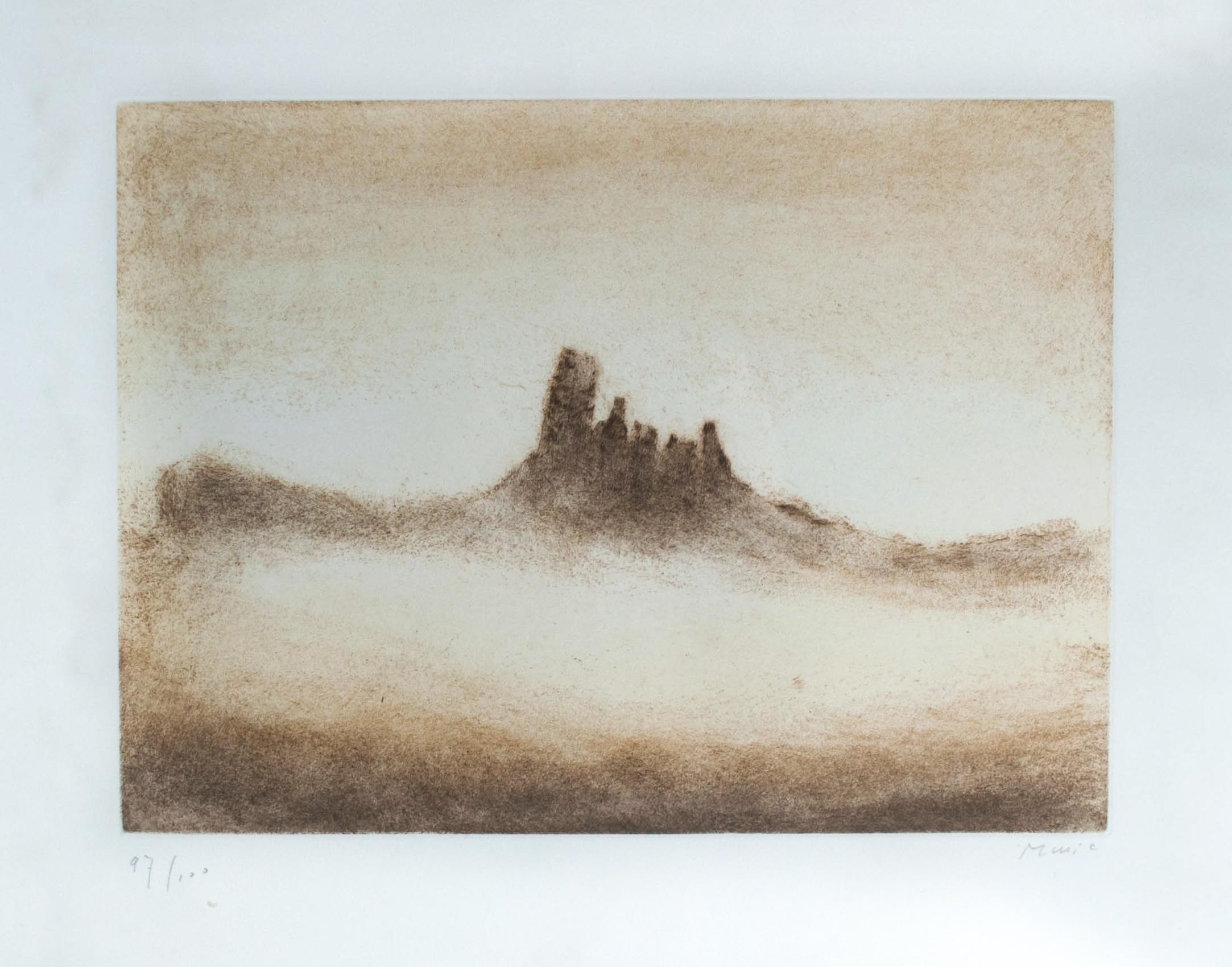
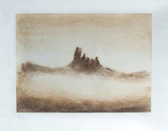
- Cinque TorriBy Zoran Antonio MusicLocated in Ljubljana, SICinque Torri. Original color drypoint and etching, 1975. Edition of 100 signed and numbered impressions on Arches paper. Zoran Mušič is one of the most celebrated Slovenian artists,...Category
1970s Post-Modern Landscape Prints
MaterialsDrypoint, Etching

Recently Viewed
View AllMore Ways To Browse
A Frame
19th Century German Art
Used World Atlas
19th Century American Light
Germany Map
19th Century Plates America
19th Century Engraving Framed
1830 America
Antique World Atlas
19th Hand Colored Engraving
Antique German Map
Antique German Maps
New Mexico Antique
19th Century Texas
Map Of North America
Canada Native American Art
Framed Map United States
Mexico Map