Items Similar to View of Seravalle, Italy: A 16th Century Hand-colored Map by Braun & Hogenberg


Want more images or videos?
Request additional images or videos from the seller
1 of 11
Franz HogenbergView of Seravalle, Italy: A 16th Century Hand-colored Map by Braun & Hogenberg1575
1575
About the Item
This is an original 16th century copperplate originally hand-colored engraved map of View of Seravalle, Italy entitled "Seravallum Celeberrimum Marchiae Tarvisiniae in Agro Foro Juliensi Opp. - Seravalli, quam vides, Spectator, iconem, operi huic nostro suis sumptib. . . ." by Georg Braun & Franz Hogenberg, from their famous city atlas "Civitates Orbis Terrarum", published in Augsberg, Germany in 1575.
The map depicts a view of Seravalle, now Vittorio Veneto, in San Marino, Italy, north of Venice, in a topographically accurate bird's-eye view from the south. A water-filled moat is seen to the south of the city walls and farmland to the east. Two men are depicted standing on a hill in the lower right in conversation next to grain sacks and a grazing horse, while a younger man behind them to the right herds a mule carrying presumably pigs. A very colorful and ornate title cartouche is in the upper center and coat-of-arms are in the right and left upper corners. Serravalle lies in an idyllic setting in the foothills and surrounded by orchards. St Mary's Cathedral with its tall bell tower is prominent in the center of the town. The marketplace and town hall with a bell tower in the square are depicted. Houses and shops are around the main square. Serravalle's importance as an agricultural centre is emphasized by the figures in the foreground. In 1337 Serravalle was conquered by the Republic of Venice. In 1866 the town was united with neighbouring Ceneda to form the town of Vittorio Veneto.
The following is an English translation of an excerpt from the French description of the city on the back of the map: "Serravalle, a market town renowned for cloth, wine and grain, is in such a beautiful situation that the number of its inhabitants, attracted by the loveliness of the place, has grown so much at times that the wall encircling it has had to be enlarged for the third time. The city with the surrounding town once belonged to the Church in Ceneda as an imperial fief. It subsequently became the seat of the Da Camino family (a princely house that at that time was one of the five most noble in all Italy). Now the city is under the sway of the Venetians but is prudently governed by them. For they send only one city councillor with instructions to ensure that justice prevails and to collect duties. In all else, power lies in the hands of the noble families."
This is a translation of the Latin in the title cartouche on the front: "The picture of the town of Serravalle, which you see, viewer, has been contributed to our work entirely at his own expense by Minutius, son of Hieronymus Minutius, a noble gentleman and one renowned for the far-reaching competence of his jurisdiction. We saw him sojourning in Cologne, where he was on business for Gregory XIII; while our good wishes accompany him, we should also like to accompany him on his way with this remembrance, even though it might be against his will, so that even those who have not seen him may learn of his excellence. However, those who do not yet know him will also see his excellence if God the Almighthy does not summon erring souls too soon back to the eternal seat of the Blessed."
References: Van der Krogt 4, 4728, State 1; Taschen, Braun and Hogenberg, p.331; Fauser, #14960
This striking hand-colored city view is printed on laid, chain-linked paper with wide margins. The sheet measures 16" high by 21" wide. There is a central vertical fold as issued and French text on the verso, with Latin on the front. There is some discoloration in the upper and right margins which may represent some watercolor paint from the time of the original hand-coloring of the map. There is a small hole to the right of the upper portion of the vertical fold, which is only visible when held up to light and an area of reinforcement on the verso of the lower vertical fold. The map is otherwise in very good to excellent condition.
Braun and Hogenberg's 'The Civitates Orbis Terrarum' was the second atlas of maps ever published and the first atlas of cities and towns of the world. It is one of the most important books published in the 16th century. Most of the maps in the atlas were engraved by Franz Hogenberg and the text, with its descriptions of the history and additional factual information of the cities, was written by a team of writers and edited by Georg Braun. The work contained 546 bird-eye views and map views of cities and towns from all over the world. It gave graphic representation of the main features of the illustrated cities and towns, including the buildings and streets. Although the ordinary buildings are stylized, the principal buildings are reproduced from actual drawings created on location. The principal landmarks and streets can still be recognized today. In addition, the maps often include the heraldic arms of the city, the nature of the surrounding countryside, the important rivers, streams and harbors, even depicting stone bridges, wooden pontoons, flat-bottomed ferries, ships and working boats, wharves and jetties, as well as land-based activities, including horsemen, pedestrians, wagons, coaches, and palanquins. Small vignettes are often included which illustrate the trade, occupations and habits of the local inhabitants, such as agriculture, paper-making and textiles, as well as local forms of punishment, such as gibbets, wheels, floggings etc. Large figures dressed in their local costume are often presented out of proportion in the foreground. The aim of the authors was to give as much information as possible in a pleasing visual form. They succeeded in creating maps that were both informative and decorative works of art. The atlas is a wonderful glimpse of life in medieval Europe.
Georg Braun (1541-1622) was German Catholic cleric who was born and who died in Cologne, Germany. He was the principal editor of 'The Civitates Orbis Terrarum', acquiring the tables, hiring the artists, and composing the texts. Abraham Ortelius, whose Theatrum Orbis Terrarum of 1570 was the first atlas of maps ever published, assisted Braun in his compilation of the details and maps for the atlas. The Civitates was intended as a companion for the Ortellius' Theatrum, as suggested by the similarity in the titles. Braun was the only survivor of the original team to live to see the publication of last volume (VI) in 1617.
Franz Hogenberg (1535-1590) was a Flemish and German painter, engraver, and mapmaker. He was born in Mechelen (also known as Malines) in Flanders, the son of an engraver. After being expelled from Antwerp by the Duke of Alva, he moved to London and then eventually to Cologne, Germany, where he met Georg Braun and Abraham Ortellius. He engraved most of the plates for Ortelius's Theatrum and the majority of those in the Civitates. Many believe that he was responsible for originating the Civitates project.
Over a hundred of different artists and cartographers, the most significant of whom was Antwerp artist Georg (Joris) Hoefnagel (1542-1600), engraved the copper-plates of the Civitates from drawings. He not only contributed most of the original material for the Spanish and Italian towns but also reworked and modified those of other contributors. After Hoefnagel's death his son Jakob continued the work for the Civitates.
- Creator:Franz Hogenberg (1540 - 1590, Flemish)
- Creation Year:1575
- Dimensions:Height: 16 in (40.64 cm)Width: 21 in (53.34 cm)
- Medium:
- Movement & Style:
- Period:
- Framing:Framing Options Available
- Condition:
- Gallery Location:Alamo, CA
- Reference Number:

Franz Hogenberg
Braun and Hogenberg's 'The Civitates Orbis Terrarum' was the second atlas of maps ever published and the first atlas of cities and towns of the world. It is one of the most important books published in the 16th century. Most of the maps in the atlas were engraved by Franz Hogenberg and the text, with its descriptions of the history and additional factual information of the cities, was written by a team of writers and edited by Georg Braun. The work contained 546 bird-eye views and map views of cities and towns from all over the world. It gave graphic representation of the main features of the illustrated cities and towns, including the buildings and streets. Although the ordinary buildings are stylized, the principal buildings are reproduced from actual drawings created on location. The principal landmarks and streets can still be recognized today. In addition, the maps often include the heraldic arms of the city, the nature of the surrounding countryside, the important rivers, streams and harbors, even depicting stone bridges, wooden pontoons, flat-bottomed ferries, ships and working boats, wharves and jetties, as well as land-based activities, including horsemen, pedestrians, wagons, coaches, and palanquins. Small vignettes are often included which illustrate the trade, occupations and habits of the local inhabitants, such as agriculture, paper-making and textiles, as well as local forms of punishment, such as gibbets, wheels, floggings etc. Large figures dressed in their local costume are often presented out of proportion in the foreground. The aim of the authors was to give as much information as possible in a pleasing visual form. They succeeded in creating maps that were both informative and decorative works of art. The atlas is a wonderful glimpse of life in medieval Europe. Georg Braun (1541-1622) was German Catholic cleric who was born and who died in Cologne, Germany. He was the principal editor of 'The Civitates Orbis Terrarum', acquiring the tables, hiring the artists, and composing the texts. Abraham Ortelius, whose Theatrum Orbis Terrarum of 1570 was the first atlas of maps ever published, assisted Braun in his compilation of the details and maps for the atlas. The Civitates was intended as a companion for the Ortellius' Theatrum, as suggested by the similarity in the titles. Braun was the only survivor of the original team to live to see the publication of last volume (VI) in 1617. Franz Hogenberg (1535-1590) was a Flemish and German painter, engraver, and mapmaker. He was born in Mechelen (also known as Malines) in Flanders, the son of an engraver. After being expelled from Antwerp by the Duke of Alva, he moved to London and then eventually to Cologne, Germany, where he met Georg Braun and Abraham Ortellius. He engraved most of the plates for Ortelius's Theatrum and the majority of those in the Civitates. Many believe that he was responsible for originating the Civitates project.
About the Seller
5.0
Vetted Seller
These experienced sellers undergo a comprehensive evaluation by our team of in-house experts.
Established in 2011
1stDibs seller since 2019
233 sales on 1stDibs
Typical response time: 1 hour
- ShippingRetrieving quote...Ships From: Alamo, CA
- Return PolicyA return for this item may be initiated within 7 days of delivery.
More From This SellerView All
- Danube River, Italy, Greece and Croatia: A Hand-colored 18th C. Homann MapBy Johann Baptist HomannLocated in Alamo, CA"Fluviorum in Europa principis Danubii" is a hand-colored map of the region about the Danube river created by Johann Baptist Homann (1663-1724) in his 'Atlas Novus Terrarum', publish...Category
Early 18th Century Old Masters Landscape Prints
MaterialsEngraving
- Meissen, Germany : A Large Framed 18th Century Map by Petrus SchenkLocated in Alamo, CAThis is a hand-colored 18th century map of the Meissen region of Germany, entitled "Geographischer Entwurff Derer Aemmter Meissen als Creys-Procuratur-Schul-und Stiffts-Ammt benebst ...Category
Mid-18th Century Old Masters Landscape Prints
MaterialsEngraving
- Northern Italy: A 16th Century Hand-colored Map by Abraham OrteliusBy Abraham OrteliusLocated in Alamo, CAThis is a framed 16th century hand-colored copperplate map of northern Italy entitled "Veronae Urbis Territorium a Bernardo Bragnolo Descriptium" by Abraham Ortelius from his atlas "Theatrum Orbis Terrarum", which was the first modern atlas of the world, with the first volume published in 1570. This map was part of a subsequent volume, published in Antwerp in 1584. It was based on an earlier map by Bernardo Brognoli. This beautiful map of northern Italy is focussed on Verona and its environs, including Mantua. Lake Garda and the South Tyrol mountains are prominently depicted. There is a very large striking cartouche in the upper left and a decorative distance scale in the lower right. This striking hand-colored map of northern Italy is presented in a gold-colored wood frame and an olive green-colored mat. It is glazed with UV conservation glass. All mounting materials used are archival. The frame measures 21.5" high by 28" wide by 0.75" deep. There is a central vertical fold, as issued, with slight separation of the lower portion of the fold. There are faint spots in the upper and right margins, but the map is otherwise in very good condition. Abraham Ortelius (also known as Ortels, Orthellius, and Wortels) (1527-1598) was a Dutch cartographer, geographer, and cosmographer. He began his career as a map colorist. In 1547 he entered the Antwerp guild of St Luke as an "illuminator of maps". He had an affinity for business from an early age and most of his journeys before 1560, were for business. He was a dealer in antiques, coins, maps, and books. His business income allowed him to acquire an extensive collection of medals, coins, and antiques, as well as a large library of books...Category
16th Century Old Masters Landscape Prints
MaterialsEngraving
- Persia, Armenia & Adjacent Regions: A Hand-colored 17th Century Map by De WitBy Frederick de WitLocated in Alamo, CAThis colorful and detailed 17th century copperplate map by Frederick De Wit was published in Amsterdam between 1666 and 1690. It depicts the Caspian Se...Category
Late 17th Century Old Masters More Prints
MaterialsEngraving
- Cartusia Bruxellensis Monastery in Brussels: A 17th C. Hand-colored EngravingBy Lucas Vorsterman the YoungerLocated in Alamo, CAThis is a 17th century hand-colored copperplate engraving entitled "Cartusia Bruxellensis" by Lucas Vorsterman, the Younger, after a drawing by Jacob van Werden or Jacques van Weerden, published in 1659 in Antonius Sanderus' book 'Chorographia sacra Brabantiae sive celebrium aliquot in ea provincia ecclesiarum et coenobiorum descriptio . . . Brussel' (A sacred chorography of Brabant, or a description of several famous churches and convents in that province). It also appeared in other publications by Sanderus. In the 17th century, Brussels was within the Duchy of Brabant. This engraving depicts a bird's-eye view of the Scheut Carthusian Monastery in Brussels. Scheut is a district of Anderlecht, a municipality of Brussels, Belgium. The monastery housed monks, who took a vow of silence, in 20 rooms. There is a central courtyard with trees and shrubs. Monks are depicted strolling along its pathways. The cells for the friars are in the middle the cloister. There are people along the streets in the foreground and to the right of the large, imposing monastery. Some are on horseback, others are walking. In the lower right, what appears to be a dog pulls a small cart containing barrels, possibly of beer or wine. Districts and neighborhoods are labelled in the background, including Scheut, Anderlecht and Ransfort. A very ornate cartouche in the lower left contains Latin and the artist's attribution. Another decorative cartouche in the upper central area contains the title. This beautifully hand-colored and detailed engraving is printed on laid, chain-linked paper with wide, full margins. The sheet measures 17.25" high and 21.25" wide. It has Latin text on the verso. It has a central vertical fold, as issued, which is reinforced on the verso. Two small spots in the lower margin may actually represent drops of watercolor paint used to color the engraving. It is otherwise in very good condition. Antonius Sanderus (1586-1664) was a Flemish Catholic cleric and historian. He was born "Antoon Sanders", but Latinized his name like many writers and scholars of his time. He was the author of several books, including 'Chorographia Sacra Brabantiae', which was illustrated with this engraving. Lucas Vorsterman the Younger (1624-between 1666 & 1676) was a Flemish Baroque engraver and draughtsman. He produced engravings after the work of contemporary painters and for books by Antwerp publishers. Jacob van Werden or Jacques van Weerden (active 1643-1669), was a Flemish draughtsman, cartographer, military engineer and archer who was active in the Habsburg Netherlands. His drawings were used as designs for prints executed by various printmakers. He worked on maps, topographical views, historical scenes, portraits and book illustrations. He had a career as a military engineer and a member of the guard of the Spanish King. He advised on various military engineering projects and was an engineer of the Spanish army...Category
Mid-17th Century Old Masters Landscape Prints
MaterialsEngraving
- L'Isle de France: A Hand-colored 17th Century Map by De WitBy Frederick de WitLocated in Alamo, CAThis colorful and detailed 17th century hand-colored copperplate map by Frederick De Wit was published in Amsterdam between 1666 and 1760. The map depicts the Île-de-France, which is one of the ancient provinces of France. Paris is located in the center of the map, with Versailles to the southwest The map extends from Rouen in the west to Reims in the east. The area around Paris, the Véxin Français, was the original domain of the king of France. Other areas were ruled by French feudal lords. For example, the Véxin Normand area was the domain of the Duke of Normandy...Category
Early 18th Century Old Masters More Prints
MaterialsEngraving


You May Also Like
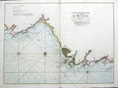
- Carte Particular Des Costes De Bretagne Depuis le Cap de Frehel, Jusques a PerrosBy Pierre MortierLocated in Paonia, COCarte Particulaire Des Costes De Bretagne Depuis Le Cap de Frehel, Jusques a Perros, & L’Isle Tome. This large sea scale chart shows part of the northwestern co...Category
1690s Landscape Prints
MaterialsEngraving
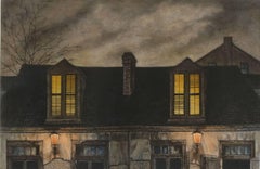
- Lafitte's Blacksmith House (a bar named for a pirate on Bourbon St, New Orleans)By Frederick MershimerLocated in New Orleans, LALafitte's Blacksmith Shop is a New Orleans landmark at 941 Bourbon St. Like most New Orleans legends, history of Lafitte's Blacksmith Shop is a gumbo of tru...Category
Early 2000s Contemporary Landscape Prints
MaterialsMezzotint, Aquatint
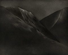
- Mont et Mervale (Mountains and Wonder)By Christine RavauxLocated in New Orleans, LABorn in Charleroi, Belgium, Christine Ravaux is an artist who mirrors her surroundings in the mezzotints she creates. She has portrayed the black hills that dot the landscape of the ...Category
1990s Contemporary Landscape Prints
MaterialsMezzotint, Aquatint
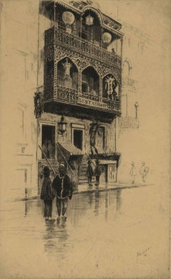
- Restaurant in Mott StreetBy Charles Frederick William MielatzLocated in New Orleans, LAThe image depicts a restaurant on New York's Mott Street with ornamental iron work on the balconies. There are six figures in the scene in various stages of contrast. Mott Street is considered the unofficial Main Street of New York's Chinatown. Ella Fitzgerald sang it best: “And tell me what street compares with Mott Street in July? Sweet pushcarts gently gliding by.” CFW Mielatz was an early influence on the drypoints and etchings of Martin Lewis. This piece was created in 1906 and it is signed in pencil. It is part of the collection of New York's Metropolitan Museum of Art C.F.W. Mielatz American, 1860-1919 Born in Bredding, Germany in 1864, Mielatz emigrated to the United States as a young boy and studied at the Chicago School of Design. Mostly self-taught, his first prints were large New England landscapes reminiscent of the painter-etcher school of American Art. Around 1890 he started to produce prints of New York City and by the time of his death, the number totaled over ninety images. He was a master technician in the field of etching, reworking many of his plates to get the exact feeling he was seeking. Mielatz was a member of the New York Etching...Category
Early 20th Century American Modern Landscape Prints
MaterialsDrypoint, Etching
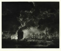
- Clairton (night view of US Steel Clairton coke plant, largest in America)By Craig McPhersonLocated in New Orleans, LAMcPherson's night view of the Clairton steelworks is printed on light green laid paper referenced as Hartley M1. It is signed, titled and dated in pencil. Marked ed 75 and "imp" in...Category
1990s American Modern Landscape Prints
MaterialsMezzotint
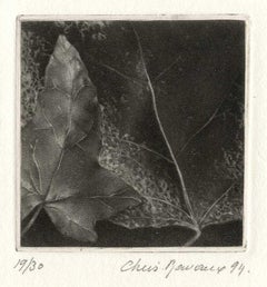
- LeavesBy Christine RavauxLocated in New Orleans, LAThis impression is #19 out of an edition 30 Born in 1961 in Charleroi, Belgium, Ravaux is an artist who mirrors her surroundings in the mezzotints she creates. She has portrayed see...Category
1990s American Modern Landscape Prints
MaterialsMezzotint
Recently Viewed
View AllMore Ways To Browse
German Old Masters
Republic Of Italy
Large Colored Stones
16th Century Hand Art
Hand Colored Italian Prints
Printed In Italy Hand Colored
Italian Old Books
Original 16th Art
16th Century Stone
16th Century English
Old Master Picture
16th Century German
Hand Painted Bells
Antique Hand Saws
Flemish 16th Century
16th Century Plate
Old Prints Of Birds
Old Master Birds