Items Similar to St. Jerome in the Desert


Want more images or videos?
Request additional images or videos from the seller
1 of 5
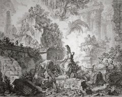
Manner of Pieter Bruegel the ElderSt. Jerome in the Desert1555-56
1555-56
About the Item
Engraving by Joannes and Lucas van Doetecum (Deventer active by 1551 - circa 1569 Haarlem) in the manner of Peter Bruegel the Elder
- Creator:Manner of Pieter Bruegel the Elder (1525 - 1569)
- Creation Year:1555-56
- Dimensions:Height: 12.5 in (31.75 cm)Width: 16.75 in (42.55 cm)
- Medium:
- Movement & Style:
- Period:
- Condition:
- Gallery Location:Chicago, IL
- Reference Number:1stDibs: LU36535746442
About the Seller
5.0
Recognized Seller
These prestigious sellers are industry leaders and represent the highest echelon for item quality and design.
Established in 1955
1stDibs seller since 2016
12 sales on 1stDibs
Typical response time: 15 hours
Associations
International Fine Print Dealers Association
- ShippingRetrieving quote...Ships From: Chicago, IL
- Return PolicyA return for this item may be initiated within 7 days of delivery.
More From This SellerView All
- Landscape with Roman RuinsBy (After) Peter Paul RubensLocated in Chicago, ILEngraving after Peter Paul Rubens (Siegen 1577 - 1640 Antwerp), executed by Schelte Adams Bolswert (Bolsward c. 1586 -1659 Antwerp). Bolswert was one of the major printmakers in the ...Category
17th Century Old Masters Landscape Prints
MaterialsEngraving
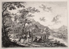
- View of the Tiber with Country LandscapeBy Jan Dirksz BothLocated in Chicago, ILEtching on paper with Schriftband watermark. Reference: Bartsch 7 III/IV (from VI). A very fine, early impression. Printed with the name of the artist, but before the addition...Category
15th Century and Earlier Old Masters Landscape Prints
MaterialsEtching
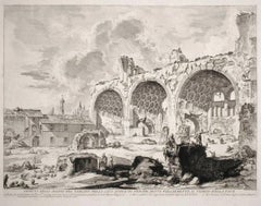
- The Basilica of ConstantineBy Giovanni Battista PiranesiLocated in Chicago, ILA very fine impression of the 3rd State, still with the address and price which were eliminated in the following 4th state. The presence of the address and price confirms that this ...Category
18th Century and Earlier Old Masters Landscape Prints
MaterialsEtching
- Vedute di Roma (3rd state) (Frontispiece of series, with Statue of Minerva)By Giovanni Battista PiranesiLocated in Chicago, ILViews of Rome (Vedute di Roma): Frontispiece for the whole series, with Statue of Minerva. A fine impression of the rare 3rd state (of seven) of this m...Category
Mid-17th Century Old Masters Landscape Prints
MaterialsEtching
- The Great Landscapes II, (4th State)By Anthonie WaterlooLocated in Chicago, ILWatermark: Schellenkappe (Foolscap) Similar to Churchill no. 340Category
17th Century Old Masters Landscape Prints
MaterialsEtching
- The Great Landscapes VI (2nd State)By Anthonie WaterlooLocated in Chicago, ILWatermark: Wappen von Amsterdam mit NebenmarkeCategory
17th Century Old Masters Landscape Prints
MaterialsEtching
You May Also Like
- Cartusia Bruxellensis Monastery in Brussels: A 17th C. Hand-colored EngravingBy Lucas Vorsterman the YoungerLocated in Alamo, CAThis is a 17th century hand-colored copperplate engraving entitled "Cartusia Bruxellensis" by Lucas Vorsterman, the Younger, after a drawing by Jacob van Werden or Jacques van Weerden, published in 1659 in Antonius Sanderus' book 'Chorographia sacra Brabantiae sive celebrium aliquot in ea provincia ecclesiarum et coenobiorum descriptio . . . Brussel' (A sacred chorography of Brabant, or a description of several famous churches and convents in that province). It also appeared in other publications by Sanderus. In the 17th century, Brussels was within the Duchy of Brabant. This engraving depicts a bird's-eye view of the Scheut Carthusian Monastery in Brussels. Scheut is a district of Anderlecht, a municipality of Brussels, Belgium. The monastery housed monks, who took a vow of silence, in 20 rooms. There is a central courtyard with trees and shrubs. Monks are depicted strolling along its pathways. The cells for the friars are in the middle the cloister. There are people along the streets in the foreground and to the right of the large, imposing monastery. Some are on horseback, others are walking. In the lower right, what appears to be a dog pulls a small cart containing barrels, possibly of beer or wine. Districts and neighborhoods are labelled in the background, including Scheut, Anderlecht and Ransfort. A very ornate cartouche in the lower left contains Latin and the artist's attribution. Another decorative cartouche in the upper central area contains the title. This beautifully hand-colored and detailed engraving is printed on laid, chain-linked paper with wide, full margins. The sheet measures 17.25" high and 21.25" wide. It has Latin text on the verso. It has a central vertical fold, as issued, which is reinforced on the verso. Two small spots in the lower margin may actually represent drops of watercolor paint used to color the engraving. It is otherwise in very good condition. Antonius Sanderus (1586-1664) was a Flemish Catholic cleric and historian. He was born "Antoon Sanders", but Latinized his name like many writers and scholars of his time. He was the author of several books, including 'Chorographia Sacra Brabantiae', which was illustrated with this engraving. Lucas Vorsterman the Younger (1624-between 1666 & 1676) was a Flemish Baroque engraver and draughtsman. He produced engravings after the work of contemporary painters and for books by Antwerp publishers. Jacob van Werden or Jacques van Weerden (active 1643-1669), was a Flemish draughtsman, cartographer, military engineer and archer who was active in the Habsburg Netherlands. His drawings were used as designs for prints executed by various printmakers. He worked on maps, topographical views, historical scenes, portraits and book illustrations. He had a career as a military engineer and a member of the guard of the Spanish King. He advised on various military engineering projects and was an engineer of the Spanish army...Category
Mid-17th Century Old Masters Landscape Prints
MaterialsEngraving
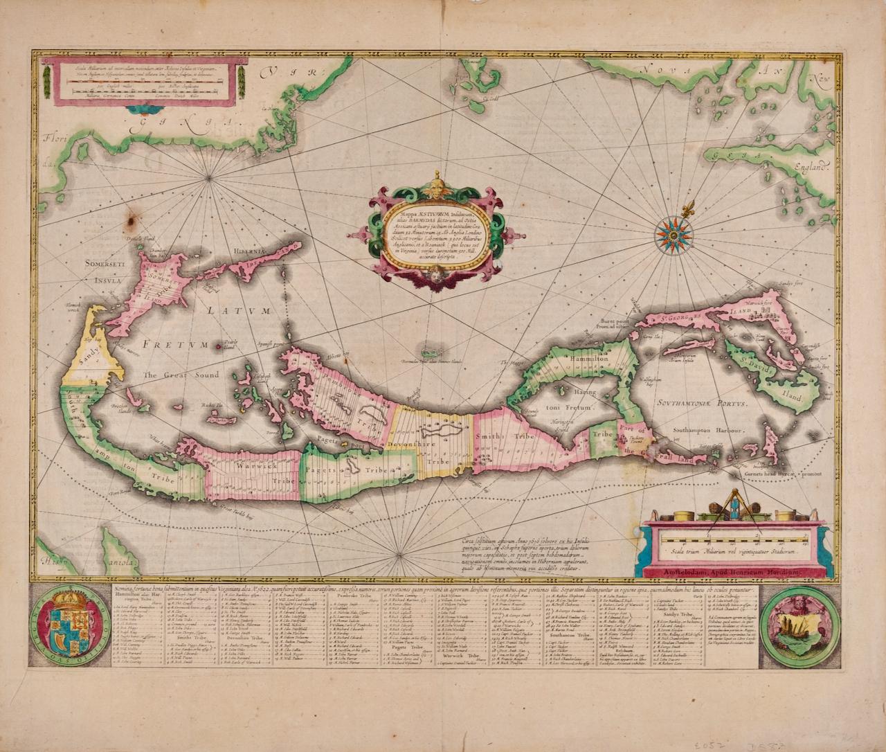
- Bermuda: An Early 17th Century Hand-colored Map by Henricus HondiusBy Henricus HondiusLocated in Alamo, CAThis attractive and interesting map of Bermuda by Henricus Hondius in 1633 is entitled "Mappa Aestivarum Insularum, Alias Barmudas". It is based on a ...Category
Early 17th Century Old Masters Landscape Prints
MaterialsEngraving
- L'Isle de France: A Hand-colored 17th Century Map by De WitBy Frederick de WitLocated in Alamo, CAThis colorful and detailed 17th century hand-colored copperplate map by Frederick De Wit was published in Amsterdam between 1666 and 1760. The map depicts the Île-de-France, which is one of the ancient provinces of France. Paris is located in the center of the map, with Versailles to the southwest The map extends from Rouen in the west to Reims in the east. The area around Paris, the Véxin Français, was the original domain of the king of France. Other areas were ruled by French feudal lords. For example, the Véxin Normand area was the domain of the Duke of Normandy...Category
Early 18th Century Old Masters More Prints
MaterialsEngraving
- Map of the Russian Empire: An Original 18th Century Hand-colored Map by E. BowenLocated in Alamo, CAThis is an original 18th century hand-colored map entitled "A New & Accurate Map of The Whole Russian Empire, As Contain'd Both In Europe and Asia, Drawn from Authentic Journals, Sur...Category
Mid-18th Century Old Masters Landscape Prints
MaterialsEngraving
- View of Emden, Germany: A 16th Century Hand-colored Map by Braun & HogenbergBy Franz HogenbergLocated in Alamo, CAThis is a 16th century original hand-colored copperplate engraved map of a bird's-eye View of Embden, Germany entitled " Emuda, vulgo Embden vrbs Frisia orientalis primaria" by Georg Braun & Franz Hogenberg, in volume II of their famous city atlas "Civitates Orbis Terrarum", published in Cologne, Germany in 1575. This is a beautifully colored and detailed map of Emden, a seaport in northwestern Germany, along the Ems River and perhaps portions of over Dollart Bay, near the border with the Netherland. The map depicts a bird's-eye view of the city from the southwest, as well as a view of the harbor and an extensive system of canals. Numerous ships of various sizes, as well as two rowboats containing numerous occupants are seen in the main waterway in the foreground and additional boats line two canals in the center of the city. Two men and two women are shown on a hill in the foreground on the right, dressed in the 16th century style of nobility. Two ornate crests are included in each corner. A title strap-work cartouche is in the upper center with the title in Latin. The crest on the right including Engelke up de Muer (The Little Angel on the Wall) was granted by Emperor Maximilian I in 1495. This is an English translation of an excerpt of Braun's description of Embden: "In Emden, the capital of East Frisia, rich merchants live in very fine houses. The city has a broad and well-situated harbour, which in my opinion is unique in Holland. Frisia and the whole of the Netherlands, for the ships can anchor here right under the city walls. They have also extended the harbour as far as the New Town, so that up to 400 ships can now find shelter here when the sea is rough." The emphasis on the harbor and waterways within the city highlights the importance of Emden's place as a seaport at this time. Embden developed from a Dutch/Flemish trading settlement in the 7th-8th centuries into a city as late as late 14th century. In 1494 it was granted staple rights, and in 1536 the harbour was extended. In the mid-16th century Emden's port was thought to have the most ships in Europe. Its population then was about 5,000, rising to 15,000 by the end of the 16th century. The Ems River flowed directly under the city walls, but its course was changed in the 17th century by the construction of a canal. Emden has canals within its city limits, a typical feature of Dutch towns, which also enabled the extension of the harbor. In 1744 Emden was annexed by Prussia and is now part of Germany. It was captured by French forces in 1757 during the Seven Years' War, but recaptured by Anglo-German forces in 1758. During the Napoleonic French era, Emden and the surrounding lands of East Frisia were part of the short-lived Kingdom of Holland. References:Van der Krogt 4, 1230, State 2; Taschen, Braun and Hogenberg...Category
16th Century Old Masters Landscape Prints
MaterialsEngraving
- Ireland: A Framed 17th Century Hand-colored Map by Jan JannsonBy Johannes JanssoniusLocated in Alamo, CAThis is a 17th century hand-colored map entitled "Hibernia Regnum Vulgo Ireland" by Johannes Janssonius's (Jan Jansson), published in Amsterdam in 1640. This highly detailed map depicts the Emerald Isle with an extensive display of towns, roads, mountains, rivers, lakes and county borders, etc. It includes two decorative cartouches on the left. The title cartouche includes the Irish harp and the second, in the upper left, includes a lion wearing a crown on the left, a unicorn on the right and a coat-of-arms in the middle, which includes another Irish harp. A distance scale is seen in the lower right, augmented with two putti. The map is embellished with three sailing ships and a sea monster. Western portions of Scotland and England...Category
Mid-17th Century Old Masters Landscape Prints
MaterialsEngraving


Recently Viewed
View AllMore Ways To Browse
The Antique
16th Engraving
Old Master 16th Century
St Jerome
Desert Engravings
Pieter Bruegel
Engraving 1555
Antique St Jerome
Dali Alpes
Retro Ski Posters Chamonix
Peter Max Moon
Antonio Fontanesi On Sale
Matte Black Sailing Ship
Extra Large Antique Wall Clock
Piranesi Lifetime
Hiroshi S
Japanese Floral Woodblock Print 1900
Ivan Rabuzin On Sale