Items Similar to A Hand Colored 18th Century Framed Map of South America by Thomas Jefferys
Want more images or videos?
Request additional images or videos from the seller
1 of 11
Thomas JefferysA Hand Colored 18th Century Framed Map of South America by Thomas Jefferys1750
1750
About the Item
This detailed hand colored map of South America by Thomas Jefferys was published in London in 1750. The map shows countries, early colonial possessions, towns, rivers, mountains, and adjacent islands as they were known or imagined at the time. The colorful cartouche shows Europeans disembarking from their ships on the rocky shores of South America. One man sitting on a large rock motions to a standing man (perhaps the leader of the exploration or ship captain) to join him in exploring further inland.
This map is presented in a brown wood frame with a blue mat. The frame measures 12.25" high x 14.325". wide x 1". There is a central vertical fold, as issued. There is some text offset, but the map is otherwise in very good condition.
Thomas Jefferys (1719-1771) was a prolific map publisher based in London. His father was a cutler, but Jefferys was apprenticed to Emanuel Bowen, a prominent mapmaker and engraver. Jefferys was the cartographer to the Prince of Wales and Geographer to King George III beginning in 1760.
- Creator:Thomas Jefferys (1719 - 1771)
- Creation Year:1750
- Dimensions:Height: 12.25 in (31.12 cm)Width: 14.25 in (36.2 cm)Depth: 1 in (2.54 cm)
- Medium:
- Period:
- Condition:
- Gallery Location:Alamo, CA
- Reference Number:
About the Seller
5.0
Vetted Seller
These experienced sellers undergo a comprehensive evaluation by our team of in-house experts.
Established in 2011
1stDibs seller since 2019
233 sales on 1stDibs
Typical response time: 1 hour
- ShippingRetrieving quote...Ships From: Alamo, CA
- Return PolicyA return for this item may be initiated within 7 days of delivery.
More From This SellerView All
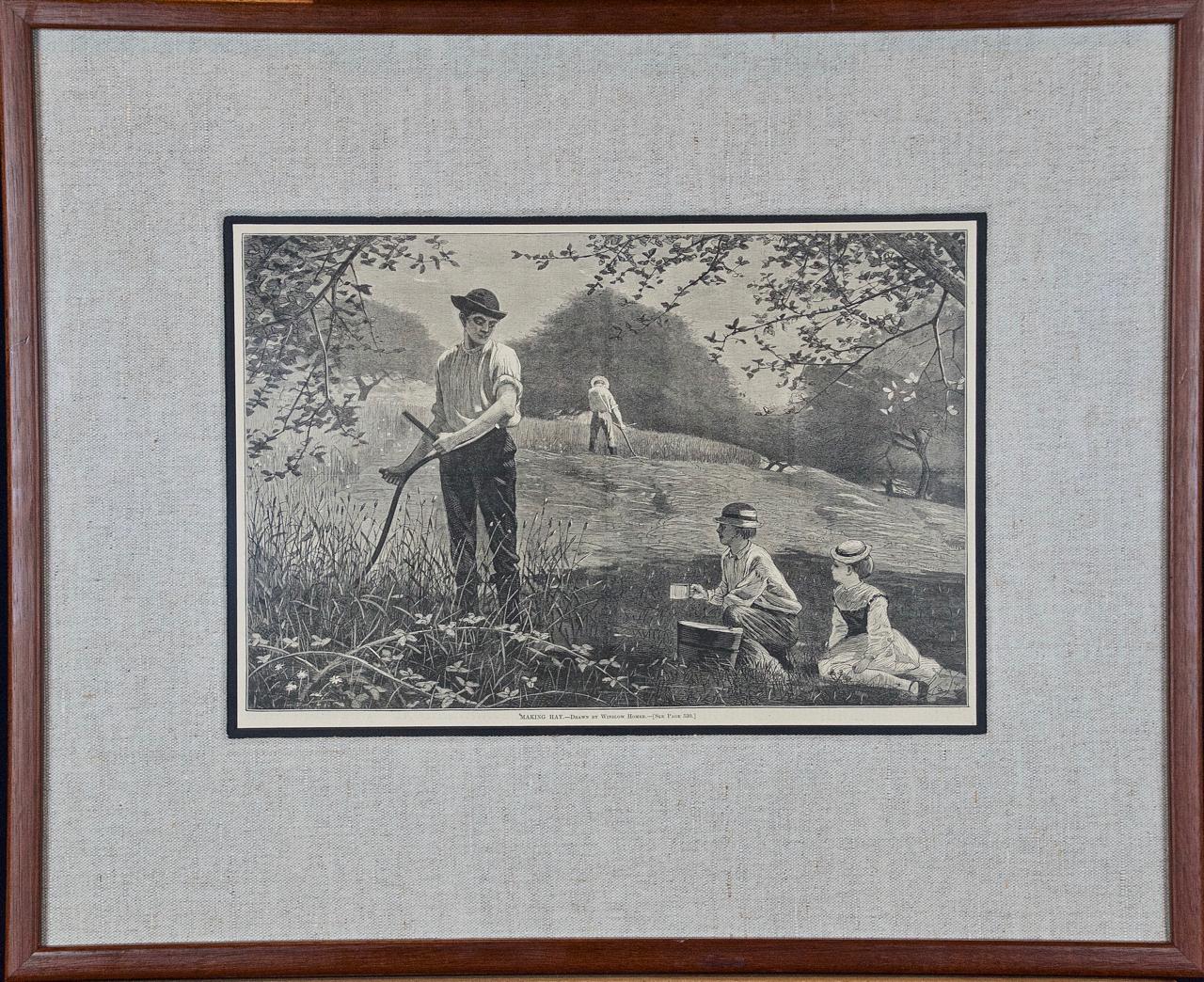
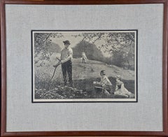
- Winslow Homer 19th Century Woodcut Engraving "Making Hay"By Winslow HomerLocated in Alamo, CAThis Winslow Homer woodcut engraving entitled "Making Hay", was published in Harper's Weekly in the July 6, 1872 edition. It depicts a two men hand cutting high grass on a hill. The man in the foreground is looking at a young boy and a girl (presumably his children), who are sitting on the ground with a picnic basket. This beautiful Homer woodcut engraving is presented in a brown wood frame and a light beige fabric mat with a black inner mat. The print is in excellent condition. There are two other Homer woodcut engravings in identical frames and mats that are listed on 1stdibs. See LU117326148332 and LU117326148272. These would make a wonderful display grouping. A discount is available for the purchase of two or all three of these prints. This Winslow Homer engraving...Category
1870s American Impressionist Landscape Prints
MaterialsWoodcut, Engraving
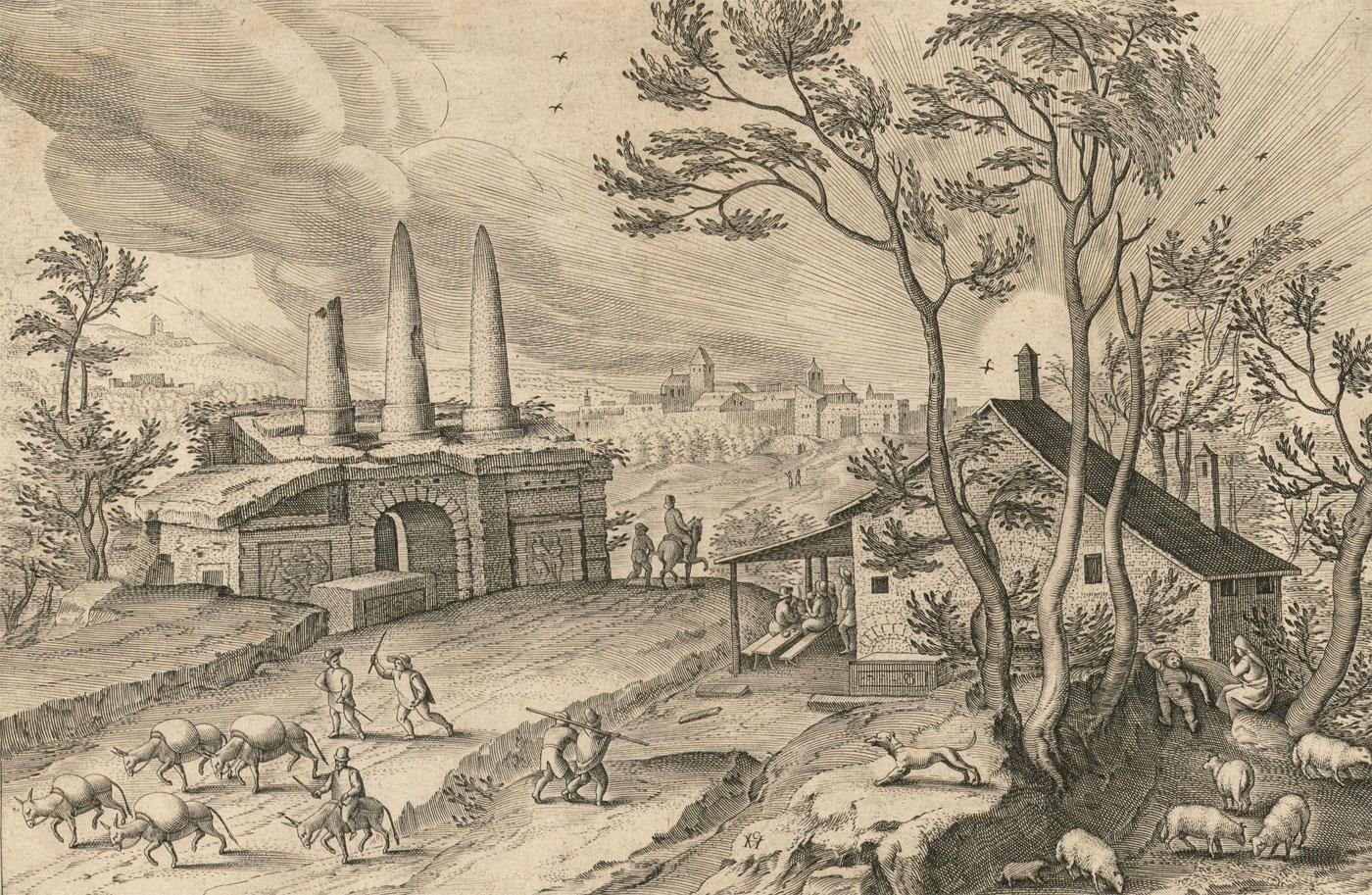
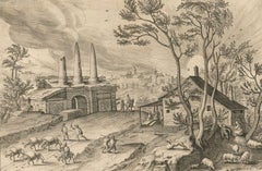
- Cartusia Bruxellensis Monastery in Brussels: A 17th C. Hand-colored EngravingBy Lucas Vorsterman the YoungerLocated in Alamo, CAThis is a 17th century hand-colored copperplate engraving entitled "Cartusia Bruxellensis" by Lucas Vorsterman, the Younger, after a drawing by Jacob van Werden or Jacques van Weerden, published in 1659 in Antonius Sanderus' book 'Chorographia sacra Brabantiae sive celebrium aliquot in ea provincia ecclesiarum et coenobiorum descriptio . . . Brussel' (A sacred chorography of Brabant, or a description of several famous churches and convents in that province). It also appeared in other publications by Sanderus. In the 17th century, Brussels was within the Duchy of Brabant. This engraving depicts a bird's-eye view of the Scheut Carthusian Monastery in Brussels. Scheut is a district of Anderlecht, a municipality of Brussels, Belgium. The monastery housed monks, who took a vow of silence, in 20 rooms. There is a central courtyard with trees and shrubs. Monks are depicted strolling along its pathways. The cells for the friars are in the middle the cloister. There are people along the streets in the foreground and to the right of the large, imposing monastery. Some are on horseback, others are walking. In the lower right, what appears to be a dog pulls a small cart containing barrels, possibly of beer or wine. Districts and neighborhoods are labelled in the background, including Scheut, Anderlecht and Ransfort. A very ornate cartouche in the lower left contains Latin and the artist's attribution. Another decorative cartouche in the upper central area contains the title. This beautifully hand-colored and detailed engraving is printed on laid, chain-linked paper with wide, full margins. The sheet measures 17.25" high and 21.25" wide. It has Latin text on the verso. It has a central vertical fold, as issued, which is reinforced on the verso. Two small spots in the lower margin may actually represent drops of watercolor paint used to color the engraving. It is otherwise in very good condition. Antonius Sanderus (1586-1664) was a Flemish Catholic cleric and historian. He was born "Antoon Sanders", but Latinized his name like many writers and scholars of his time. He was the author of several books, including 'Chorographia Sacra Brabantiae', which was illustrated with this engraving. Lucas Vorsterman the Younger (1624-between 1666 & 1676) was a Flemish Baroque engraver and draughtsman. He produced engravings after the work of contemporary painters and for books by Antwerp publishers. Jacob van Werden or Jacques van Weerden (active 1643-1669), was a Flemish draughtsman, cartographer, military engineer and archer who was active in the Habsburg Netherlands. His drawings were used as designs for prints executed by various printmakers. He worked on maps, topographical views, historical scenes, portraits and book illustrations. He had a career as a military engineer and a member of the guard of the Spanish King. He advised on various military engineering projects and was an engineer of the Spanish army...Category
Mid-17th Century Old Masters Landscape Prints
MaterialsEngraving
- Bermuda: An Early 17th Century Hand-colored Map by Henricus HondiusBy Henricus HondiusLocated in Alamo, CAThis attractive and interesting map of Bermuda by Henricus Hondius in 1633 is entitled "Mappa Aestivarum Insularum, Alias Barmudas". It is based on a ...Category
Early 17th Century Old Masters Landscape Prints
MaterialsEngraving
- L'Isle de France: A Hand-colored 17th Century Map by De WitBy Frederick de WitLocated in Alamo, CAThis colorful and detailed 17th century hand-colored copperplate map by Frederick De Wit was published in Amsterdam between 1666 and 1760. The map depicts the Île-de-France, which is one of the ancient provinces of France. Paris is located in the center of the map, with Versailles to the southwest The map extends from Rouen in the west to Reims in the east. The area around Paris, the Véxin Français, was the original domain of the king of France. Other areas were ruled by French feudal lords. For example, the Véxin Normand area was the domain of the Duke of Normandy...Category
Early 18th Century Old Masters More Prints
MaterialsEngraving
- Map of the Russian Empire: An Original 18th Century Hand-colored Map by E. BowenLocated in Alamo, CAThis is an original 18th century hand-colored map entitled "A New & Accurate Map of The Whole Russian Empire, As Contain'd Both In Europe and Asia, Drawn from Authentic Journals, Sur...Category
Mid-18th Century Old Masters Landscape Prints
MaterialsEngraving
- Ulysses Deriding Polyphemus: A Framed 19th C. Engraving After J. M. W. TurnerBy J.M.W. TurnerLocated in Alamo, CAThis beautiful 19th century framed hand-colored engraving/etching entitled "Ullyses Deriding Polyphemus" by Edward Goodall is based on an original 1829 painting by the renowned Briti...Category
Mid-19th Century Romantic Landscape Prints
MaterialsEngraving, Etching


You May Also Like
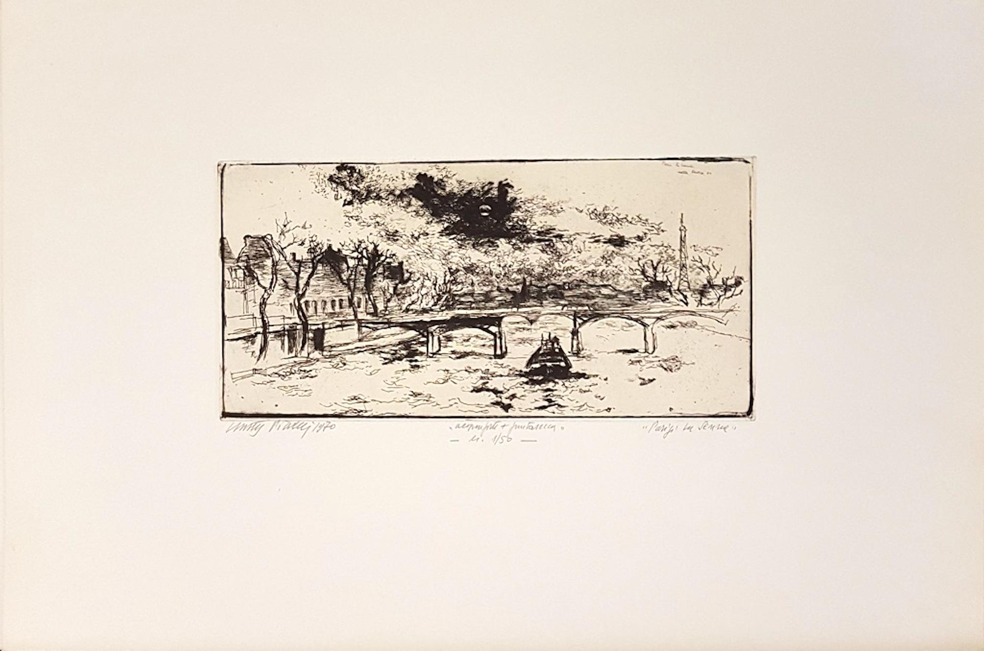
- Paris Along the Seine - Original Etching by Walter PIacesi - 1970By Walter PiacesiLocated in Roma, ITInteresting b/w etching and drypoint, representing the Parisian foreshortening of a bridge on the Seine. Edition of 50 prints. Signature, date, technique and print run, title handwri...Category
1970s Landscape Prints
MaterialsDrypoint, Etching
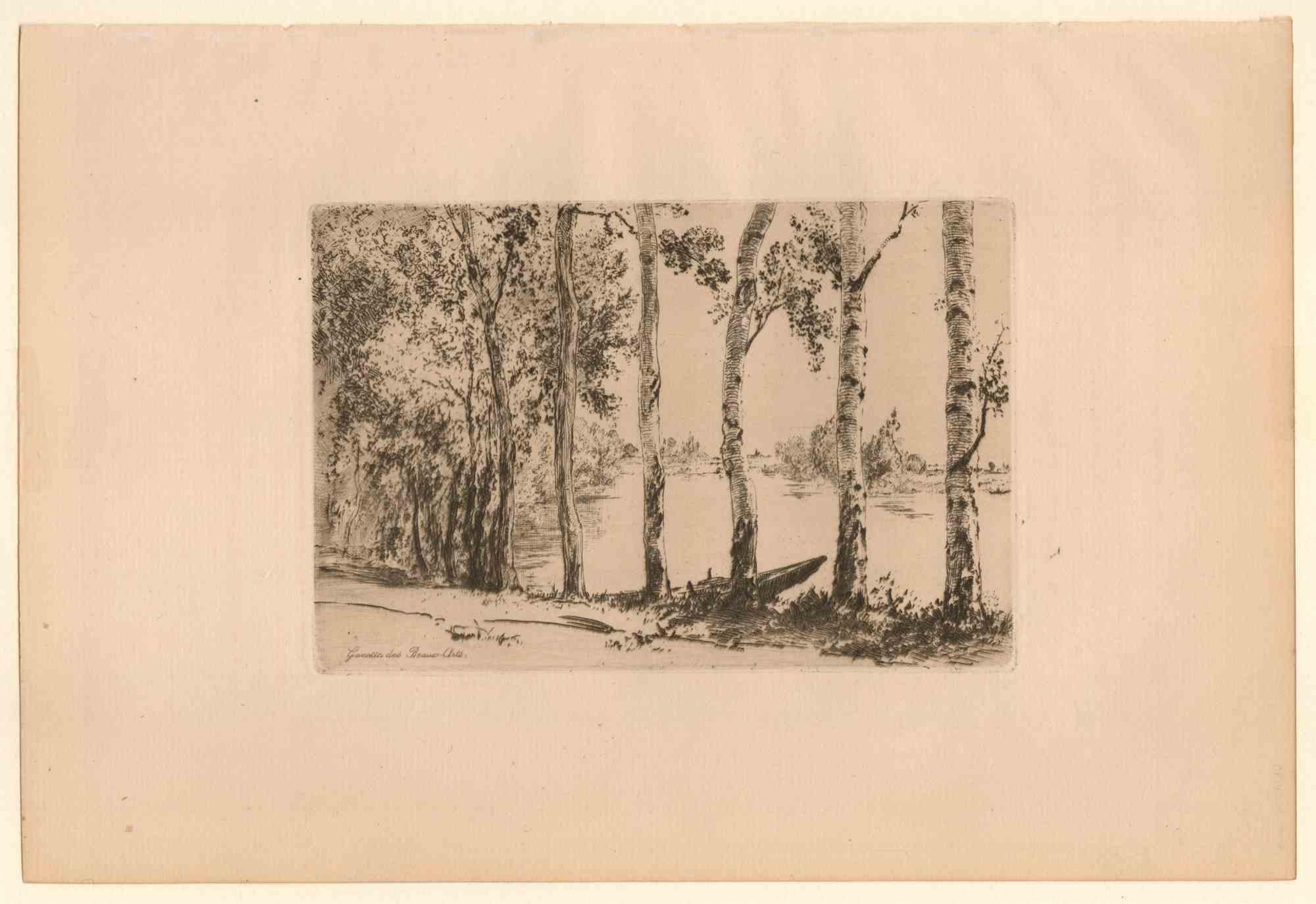
- Trembles au Bord de la Seine - Etching and Dry point - 19th CenturyLocated in Roma, ITTrembles au bord de la Seine is an Etching and Drypoint realized by an anonymous artist in The 19th Century. Edition for 'Gazette des Beaux-Arts', inscribed on plate. Beraldi, no. 2...Category
19th Century Modern Figurative Prints
MaterialsDrypoint, Etching
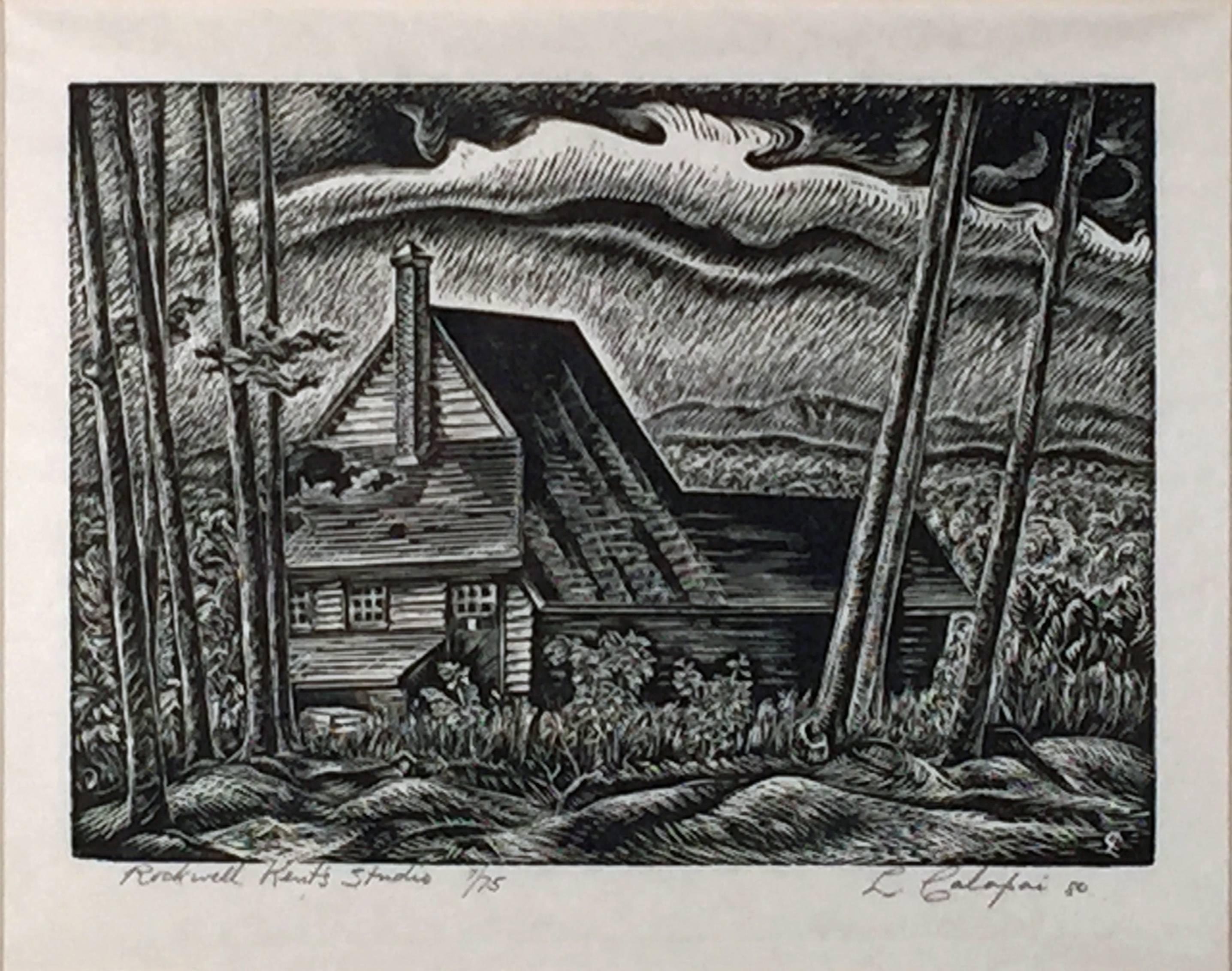
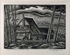
- ROCKWELL KENT'S STUDIOBy Letterio CalapaiLocated in Portland, MECalapai, Letterio. ROCKWELL KENT'S STUDIO. Wood engraving, 1980. Titled, numbered 7/75 and signed in pencil. 6 x 8 7/16 inches, 153 x 216 mm. In very good condition. Framed.Category
1980s American Realist Landscape Prints
MaterialsWoodcut, Engraving
- P Galle after Hendrick van Cleve - 1585 Engraving, Sepulcrum trium HoratiorumLocated in Corsham, GBPhilips Galle after Hendrick van Cleve III An extremely fine Dutch engraving on laid paper. Italian landscape with probably the ruin of the cemetery o...Category
18th Century Landscape Prints
MaterialsEngraving
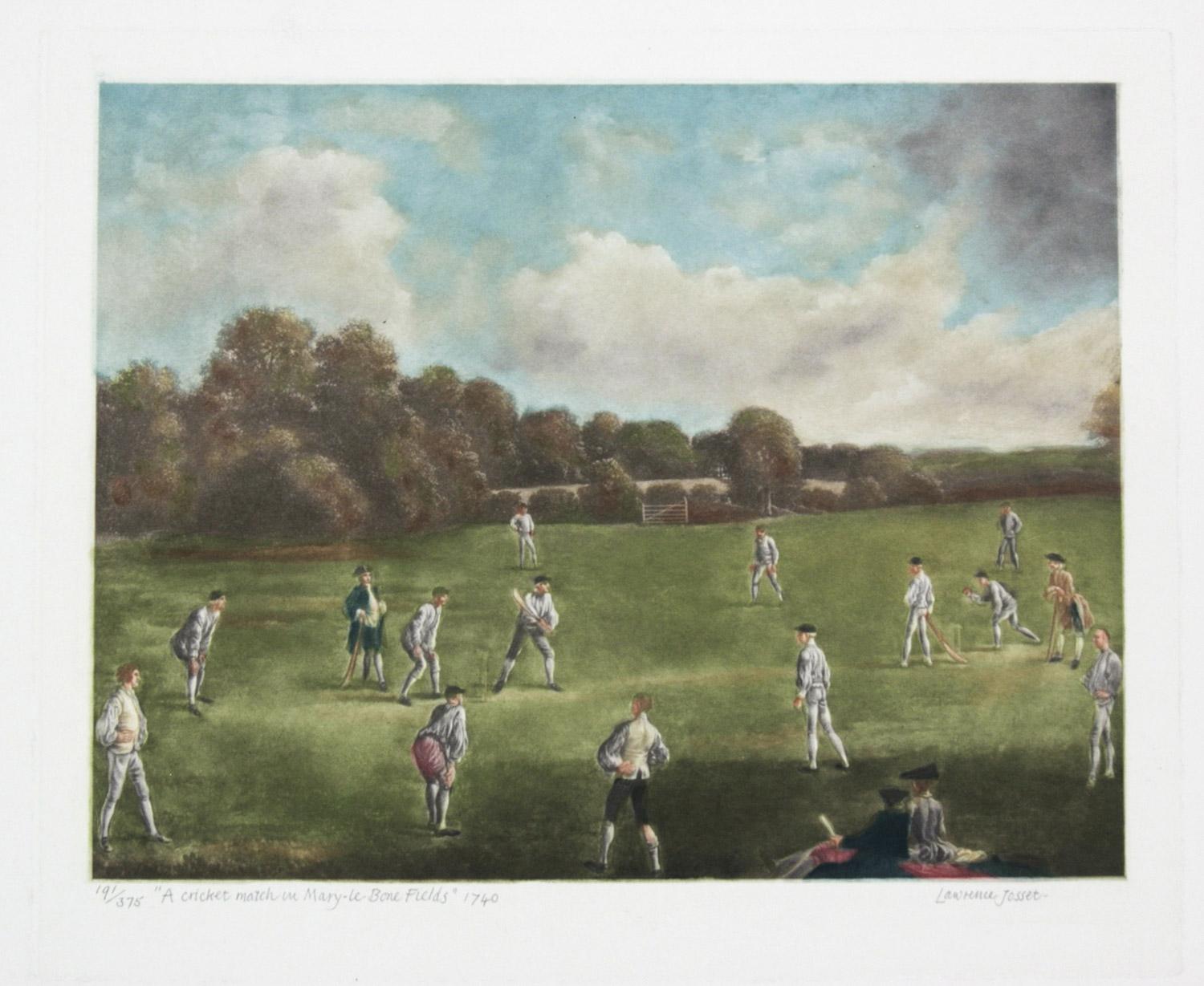
- A Cricket Match at Mary-le-Bone Fields by Lawrence JossetLocated in Paonia, COLawrence Jossett ( 1910 – 1995 ) was born in Cambridgeshire England. He acquired his knowledge and skill as an engraver of bank notes. His natural talent and his attention to detail ...Category
20th Century Figurative Prints
MaterialsMezzotint
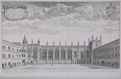
- David Loggan: New College, Oxford 1690 engravingBy David LogganLocated in London, GBTo see our other views of Oxford and Cambridge, scroll down to "More from this Seller" and below it click on "See all from this seller" - or send us a message if you cannot find the view you want. David Loggan (1634-1692) New College...Category
1690s Realist Landscape Prints
MaterialsEngraving


Recently Viewed
View AllMore Ways To Browse
Antique Brown Wood
18th Century Framed
Thomas Hand
American 18th
Thomas Wood
Large Antique Style Frames
The Prince Of Wales
Frame Print 18th Century
Colonial American Art
18th Century Framed Art Print
18th Century Colored Engraving
Ship Captain
18th Century Wales
Antique Framed Maps
Framing Antique Maps
Framed Antique Maps
Framed Antique Map
18th Century American Prints