Items Similar to 17th Century Topographical Map, French Champagne Region, Epernay, Iohan Peeters

Want more images or videos?
Request additional images or videos from the seller
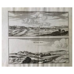
17th Century Topographical Map, French Champagne Region, Epernay, Iohan Peeters
About the Item
Fine topographical 17th century map by Iohan Peeters of the towns of Epernay and Lametz in the Champagne Region of North Eastern France.
Fabulous period engraving for a Wine Cellar, Bar, Dining Room.
Other similar pieces are available.
Espernay, early spelling of the famed Capital of Champagne, Epernay is depicted surrounded by rolling hills whose famed slopes are now covered with vineyards producing the storied wines the town is known for. The Marne river is identified on the left and three horse riders in 17th century attire, possibly Musketeers, are in the foreground right.
Lametz, a charming municioality in the Champagne-Ardenne region, with a detailed group of travelers at lower left and a figure with his dog on the right headed on the road towards the town. Seiruze, Chauny, Mouzon, Lion, Doul and Stenay are identified in the background.
Fine antique engraving of beautiful detail and workmanship.
In excellent condition commensurate with age.
Size: 15.5 inches by 12.38 inches
Iohan Peeters Delin. Topographia Galliae ... Het tweede deel. Amsterdam : By de Weduw van Ioost Broersz en Casper Meriaen, 1661
- Dimensions:Height: 12.38 in (31.45 cm)Width: 15.5 in (39.37 cm)Depth: 0 in (0 mm)
- Materials and Techniques:
- Place of Origin:
- Period:
- Date of Manufacture:17th Century
- Condition:Wear consistent with age and use.
- Seller Location:New York, NY
- Reference Number:1stDibs: LU5828228731942
About the Seller
5.0
Gold Seller
These expertly vetted sellers are highly rated and consistently exceed customer expectations.
1stDibs seller since 2021
32 sales on 1stDibs
Typical response time: 1 hour
- ShippingRetrieving quote...Ships From: New York, NY
- Return PolicyA return for this item may be initiated within 3 days of delivery.
More From This SellerView All
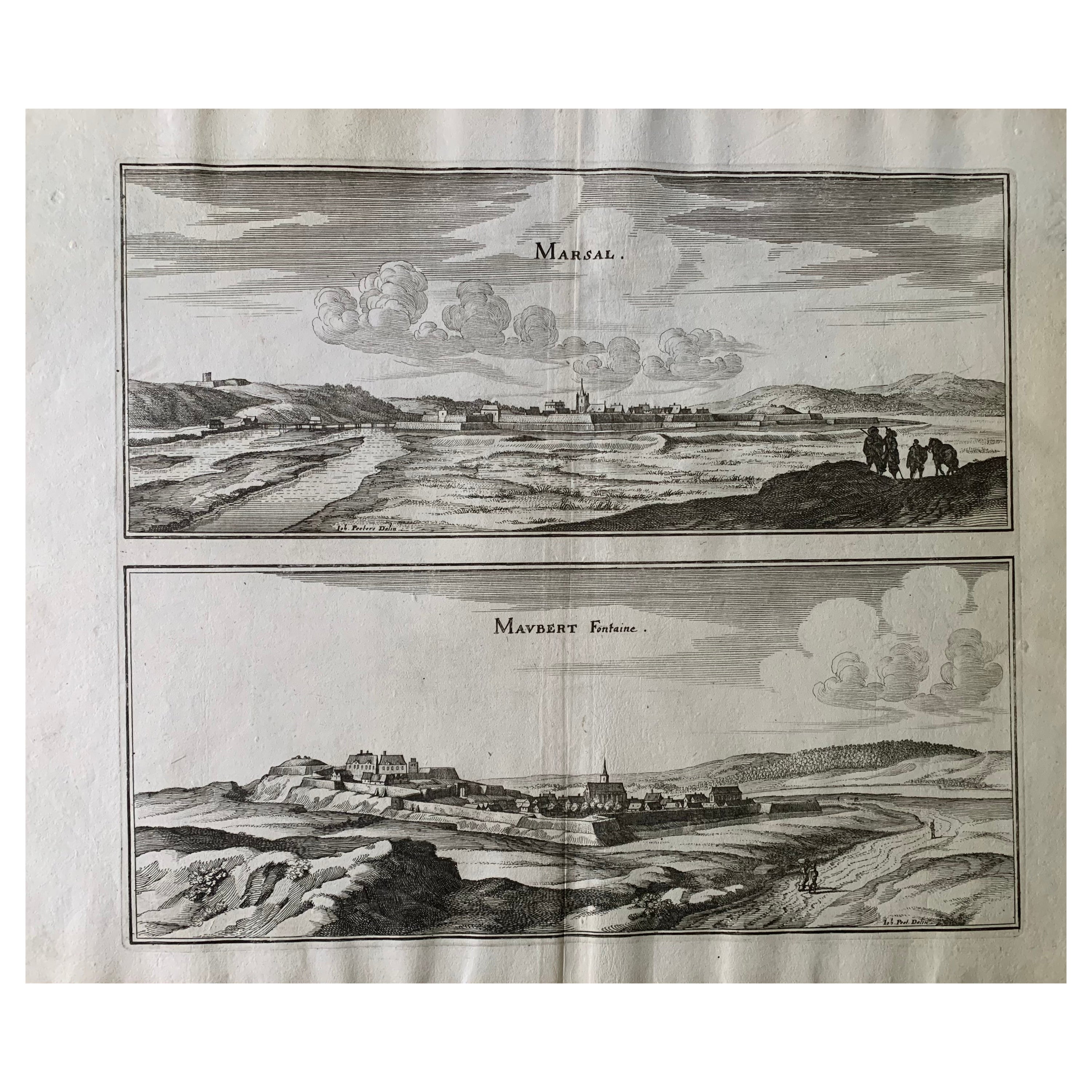
- 17th Century Topographical Map, Champagne-Ardenne, Marsal, Maubert Iohan PeetersLocated in New York, NYFine topographical 17th century map by Iohan Peeters of Marsal and Maubert Fontaine in the Champagne-Ardennes Region of North Eastern France. Fabulous period engraving for a Wine Ce...Category
Antique 17th Century Dutch Maps
MaterialsPaper
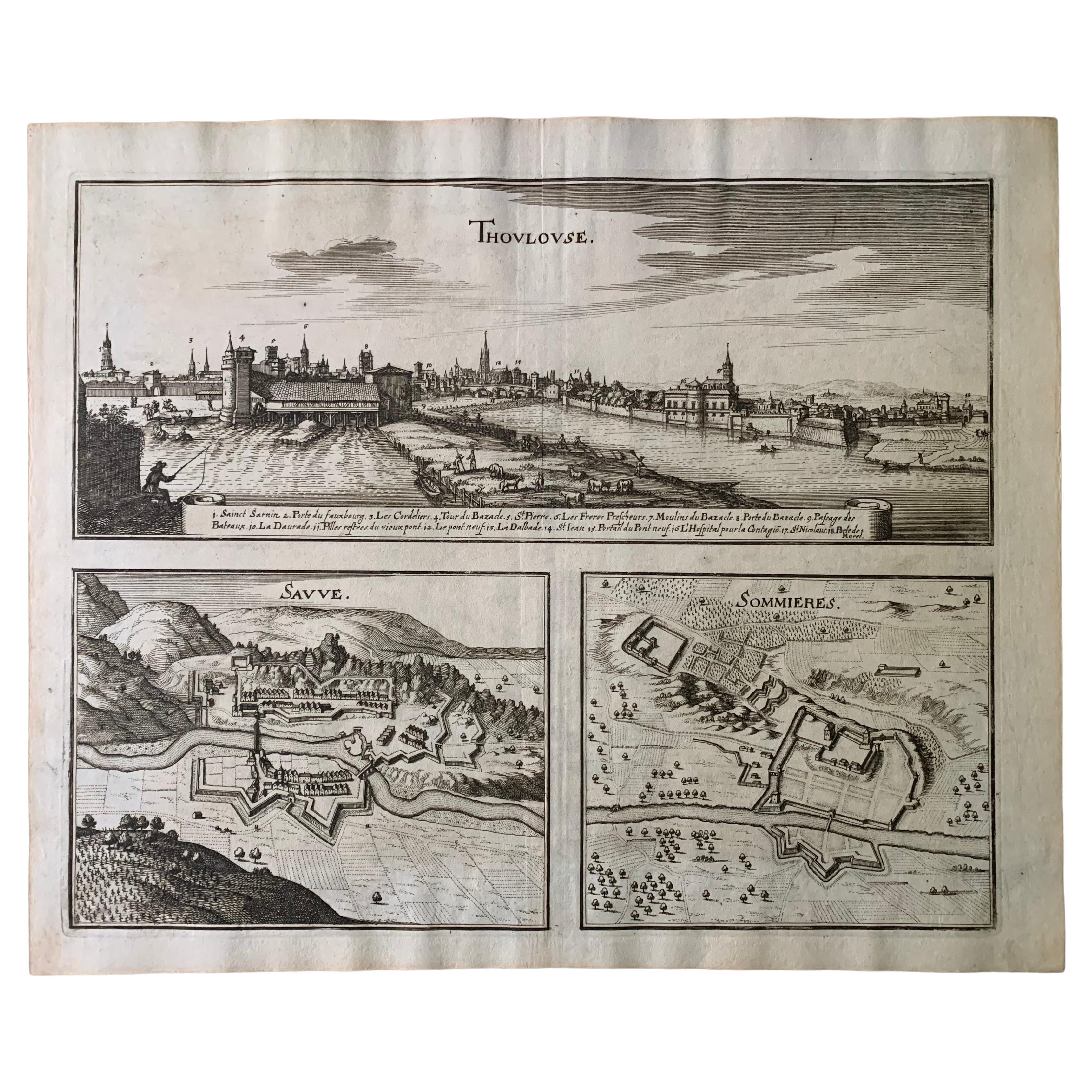
- 17th Century Toulouse, Savve, Sommieres Topographical Map by Iohan PeetersLocated in New York, NYFine topographical 17th century map of Toulouse, Savve and Sommieres by Iohan Peeters Beautiful engraving of the capital of France's Occitanie Region, Toulouse, called La Ville Rose- the Pink City, for the terracotta bricks used in its many buildings, giving the city a distinct apricot-rose hue. An important cultural and educational center, the city's residents included Nobel Prize winners and world renown artists- Henri de Toulouse-Lautrec, Henri Martin, Jean-Auguste-Dominique Ingres, Antonin Mercie, Alexandre Falguiere and more recently Cyril Kongo...Category
Antique 17th Century Dutch Maps
MaterialsPaper
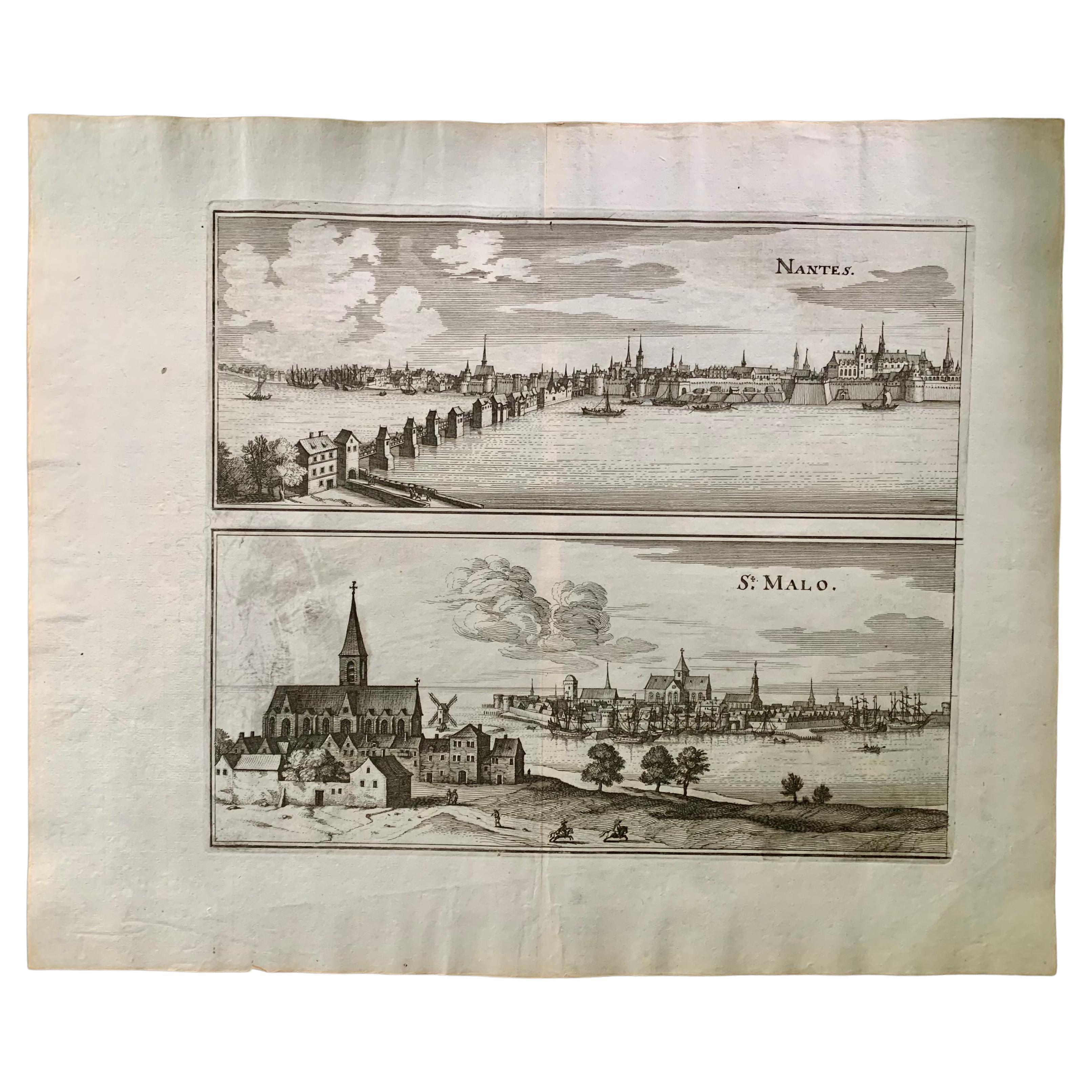
- 17th Century Topographical Engraving Nantes & St. Malo, France, by Iohan PeetersLocated in New York, NYThe ancient city of Saint Malo in North Western France has long been associated with adventure on the high seas, piracy and exploration. It was the birthplace of several important in...Category
Antique 17th Century Dutch Maps
MaterialsPaper
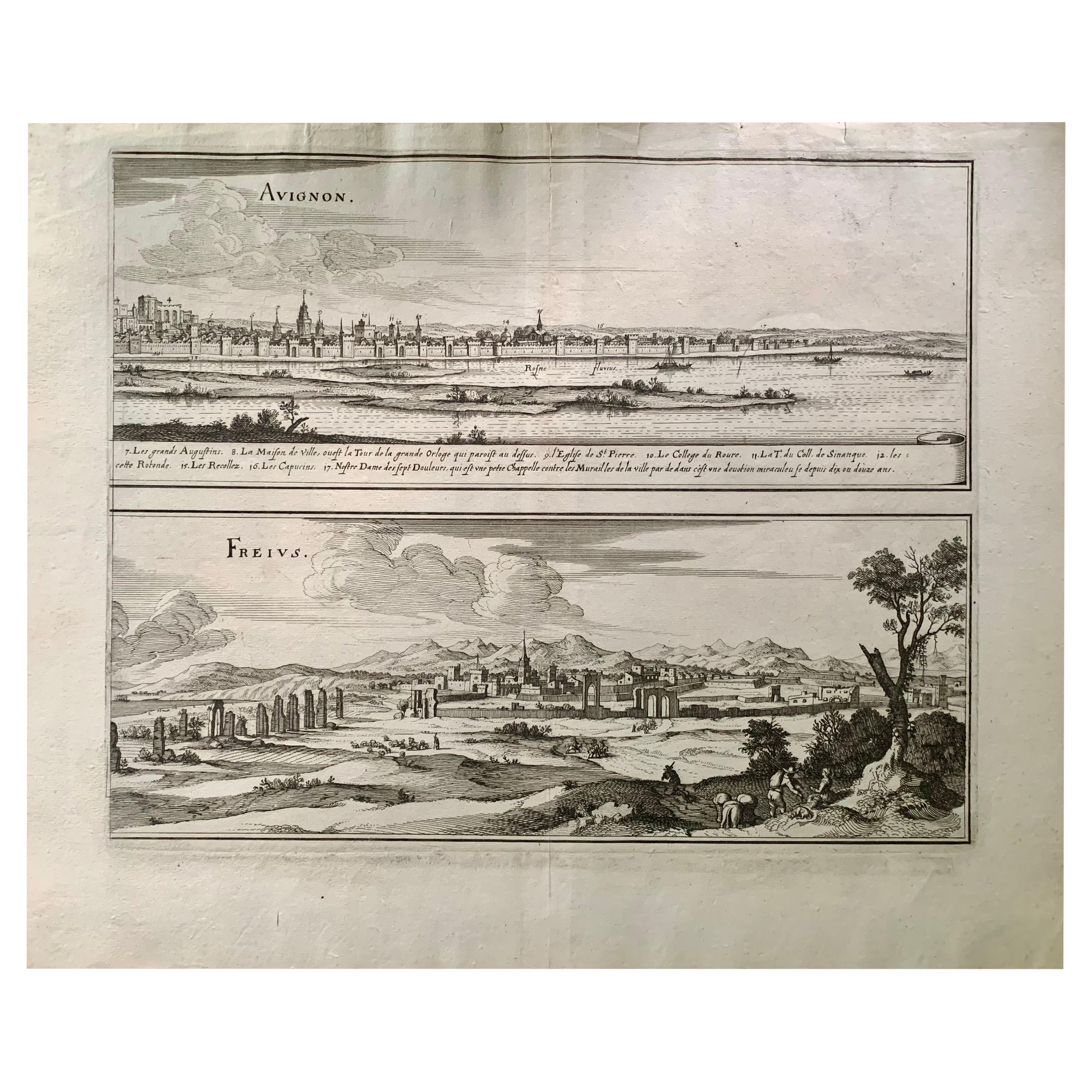
- 17th Century Topographical Map of Cote D'azur, Avignon, Frejus by Iohan PeetersLocated in New York, NYFine topographical 17th century map by Iohan Peeters of the towns of Avignon and Frejus in the Cote d'Azur-Provence-Alpes Region of Southeastern France. Beautifully suited decorativ...Category
Antique 17th Century Dutch Maps
MaterialsPaper
- Neil Welliver Nocturnal Grace Limited Edition Aquatint, 20th CenturyBy Neil WelliverLocated in New York, NYA fine Neil Welliver aquatint on embossed Rives BFK paper, pencil signed, titled and numbered 32/500 in the lower margin. Professional framing in a natural wood frame and matting in ...Category
20th Century American Modern Prints
MaterialsPaper
- Large Antique Russian Icon Resurrection and Great Feast Days, 18th-19th CenturyLocated in New York, NYLarge antique late 18th century- early 19th century Russian icon of the Resurrection with Great Feasts. Original condition with beautiful age-old patina. The central area depicting t...Category
Antique Late 18th Century Russian Religious Items
MaterialsWood


You May Also Like
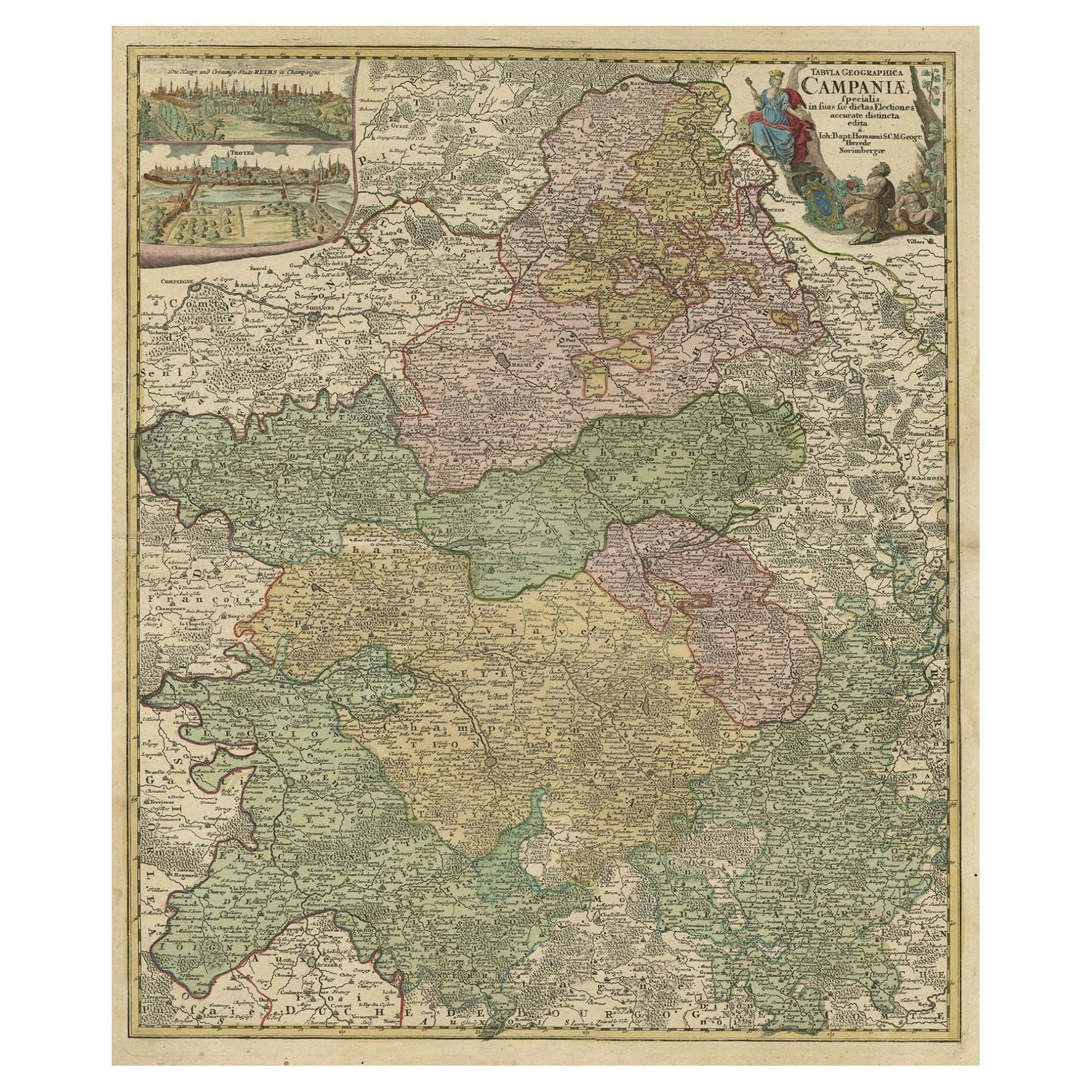
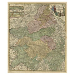
- Old Map of Region Champagne-Ardenne with Reims, Troyes & Épernay in France, 1759Located in Langweer, NLAntique map titled 'Tabula Geographica Campaniae (..).' Detailed map of the Champagne region in France by J. B. Homann, covering the region Champagne-Ardenne with Reims, Troyes a...Category
Antique 1750s Maps
MaterialsPaper
- 17th Century Hand-Colored Map of a Region in West Germany by JanssoniusBy Johannes JanssoniusLocated in Alamo, CAThis attractive highly detailed 17th century original hand-colored map is entitled "Archiepiscopatus Maghdeburgensis et Anhaltinus Ducatus cum terris adjacentibus". It was published ...Category
Antique Mid-17th Century Dutch Maps
MaterialsPaper
- The Normandy Region of France: A 17th C. Hand-colored Map by Sanson and JaillotBy Nicolas SansonLocated in Alamo, CAThis large hand-colored map entitled "Le Duché et Gouvernement de Normandie divisée en Haute et Basse Normandie en divers Pays; et par evêchez, avec le Gouvernement General du Havre ...Category
Antique 1690s French Maps
MaterialsPaper
- 17th Century Hand Colored Map of the Liege Region in Belgium by VisscherBy Nicolaes Visscher IILocated in Alamo, CAAn original 17th century map entitled "Leodiensis Episcopatus in omnes Subjacentes Provincias distincté divisusVisscher, Leodiensis Episcopatus" by Nicolaes Visscher II, published in Amsterdam in 1688. The map is centered on Liege, Belgium, includes the area between Antwerp, Turnhout, Roermond, Cologne, Trier and Dinant. This attractive map is presented in a cream-colored mat measuring 30" wide x 27.5" high. There is a central fold, as issued. There is minimal spotting in the upper margin and a tiny spot in the right lower margin, which are under the mat. The map is otherwise in excellent condition. The Visscher family were one of the great cartographic families of the 17th century. Begun by Claes Jansz Visscher...Category
Antique Late 17th Century Dutch Maps
MaterialsPaper
- 17th Century Map of Denmark by French Cartographer Sanson, Dated 1658By Nicolas SansonLocated in Copenhagen, K17th century map of Denmark by French cartographer Sanson. Nicolas Sanson (20 December 1600-7 July 1667) was a French cartographer, termed by some the creator of French geography an...Category
Antique 17th Century French Maps
MaterialsPaper
- "Africa Vetus": a 17th Century Hand-Colored Map by SansonBy Nicolas SansonLocated in Alamo, CAThis original hand-colored copperplate engraved map of Africa entitled "Africa Vetus, Nicolai Sanson Christianiss Galliar Regis Geographi" was originally created by Nicholas Sanson d...Category
Antique Late 17th Century French Maps
MaterialsPaper


Recently Viewed
View AllMore Ways To Browse
Wine Cellar Bar
17th Century Netherlands
17th Century French Dining
Champagne Antique
Antique Champagne
Antique Wine Cellars
Wine Vineyard
Wine Region
Champagne Cover
France Wine Region
Antique Dog Collectibles
17th Century Horse
Horse Antiques Collectables
Lion Engraving
Vineyard Antiques
Wine Map
Wine Maps
Engraving Dog