Items Similar to 1855 "New-York City & County Map" by Charles Magnus


Want more images or videos?
Request additional images or videos from the seller
1 of 5
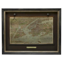
1855 "New-York City & County Map" by Charles Magnus
About the Item
This is a beautiful hand-colored map titled “New York City & County Map with Vicinity entire Brooklyn, Williamsburgh, Jersey City &c.” The work was published in 1855 by Charles Magnus and is presented in a wooden archival frame.
Published by one of the best known and most prosperous printers in the mid to late 19th century, this map is wonderfully detailed. Turned clockwise so that cardinal west is at the top of the map, this is an unusual and attractive depiction of the city. The map shows the entirety of Manhattan as well as nearby neighborhoods. The map lends special attention to individual streets, blocks, parks and even important buildings. Magnus shows important ferry crossings, canals, and railroads as well with steamships navigating the Hudson River.
Centered on Manhattan, the map identifies additional districts including Manhattanville, Yorkville, and Harlem. Several areas have changed since the 1855 map was completed and some of the planned landfill is visible around Hoboken and Jersey City. Other sites have notably changed such as New York Lunatic Asylum that is in place of the modern site of Columbia University. At the bottom center of the map an alphanumerically keyed legend notes 'Universities, Colleges and Scientific and Literary, Benevolent-Institutions,' 'Public Buildings' and 'Places of Amusement.' An illustration of the New York City Hall adorns the bottom left of the map and is balanced by the full text of the Declaration of Independence surrounded by an elaborate medallion at the bottom right. The map is beautifully decorated with acanthus leaf motif border. Overall, this map is an appealing example of Magnus printing and New York City in the mid-19th century.
Condition:
Overall good condition. The map has some foxing throughout from age and mild color loss. One crease runs down the middle of the once-folded map. Otherwise, the colors are still vibrant and the map is free of any tears. A publisher's mark, Charles Magnus 12, is visible at the bottom left corner as well as directly underneath the text of the Declaration of Independence. The map is framed according to archival standards and sits behind UV protective glass.
- Creator:Charles Magnus (Maker)
- Dimensions:Height: 36 in (91.44 cm)Width: 49 in (124.46 cm)Depth: 2.5 in (6.35 cm)
- Materials and Techniques:
- Place of Origin:
- Period:
- Date of Manufacture:1855
- Condition:Wear consistent with age and use.
- Seller Location:Colorado Springs, CO
- Reference Number:Seller: M2781stDibs: LU909717754532
About the Seller
4.9
Vetted Seller
These experienced sellers undergo a comprehensive evaluation by our team of in-house experts.
Established in 2010
1stDibs seller since 2011
419 sales on 1stDibs
Typical response time: <1 hour
- ShippingRetrieving quote...Ships From: Colorado Springs, CO
- Return PolicyA return for this item may be initiated within 10 days of delivery.
Authenticity Guarantee
In the unlikely event there’s an issue with an item’s authenticity, contact us within 1 year for a full refund. DetailsMoney-Back Guarantee
If your item is not as described, is damaged in transit, or does not arrive, contact us within 7 days for a full refund. Details24-Hour Cancellation
You have a 24-hour grace period in which to reconsider your purchase, with no questions asked.Vetted Professional Sellers
Our world-class sellers must adhere to strict standards for service and quality, maintaining the integrity of our listings.Price-Match Guarantee
If you find that a seller listed the same item for a lower price elsewhere, we’ll match it.Trusted Global Delivery
Our best-in-class carrier network provides specialized shipping options worldwide, including custom delivery.More From This Seller
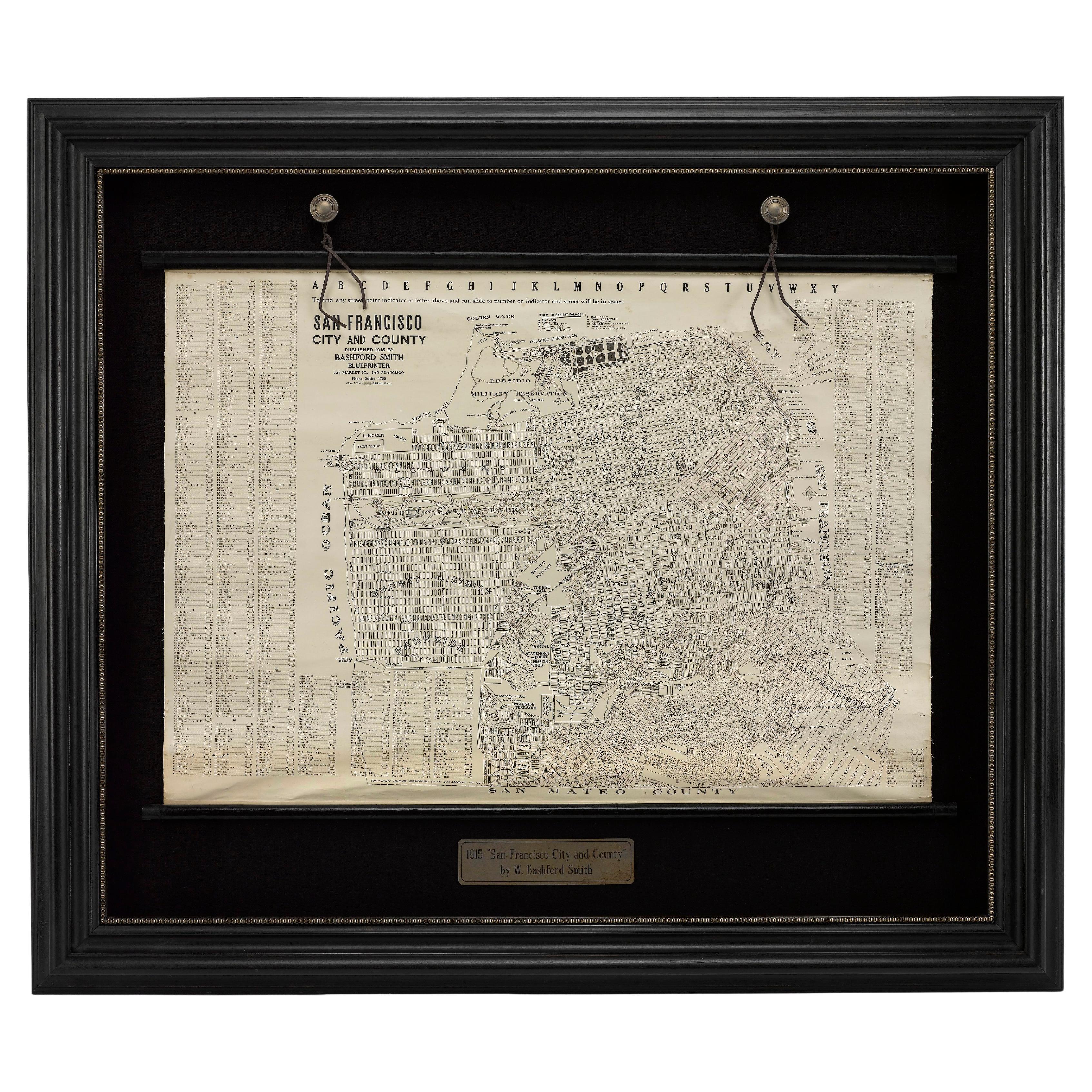
View All1915 "San Francisco City and County" Hanging Map by W. Bashford Smith
Located in Colorado Springs, CO
Presented is a rare wall map of San Francisco by W. Bashford Smith. Published in San Francisco in 1915, this map indicates streets and city districts, and, most notably, shows the si...
Category
Vintage 1910s American Art Deco Maps
Materials
Wood, Paper

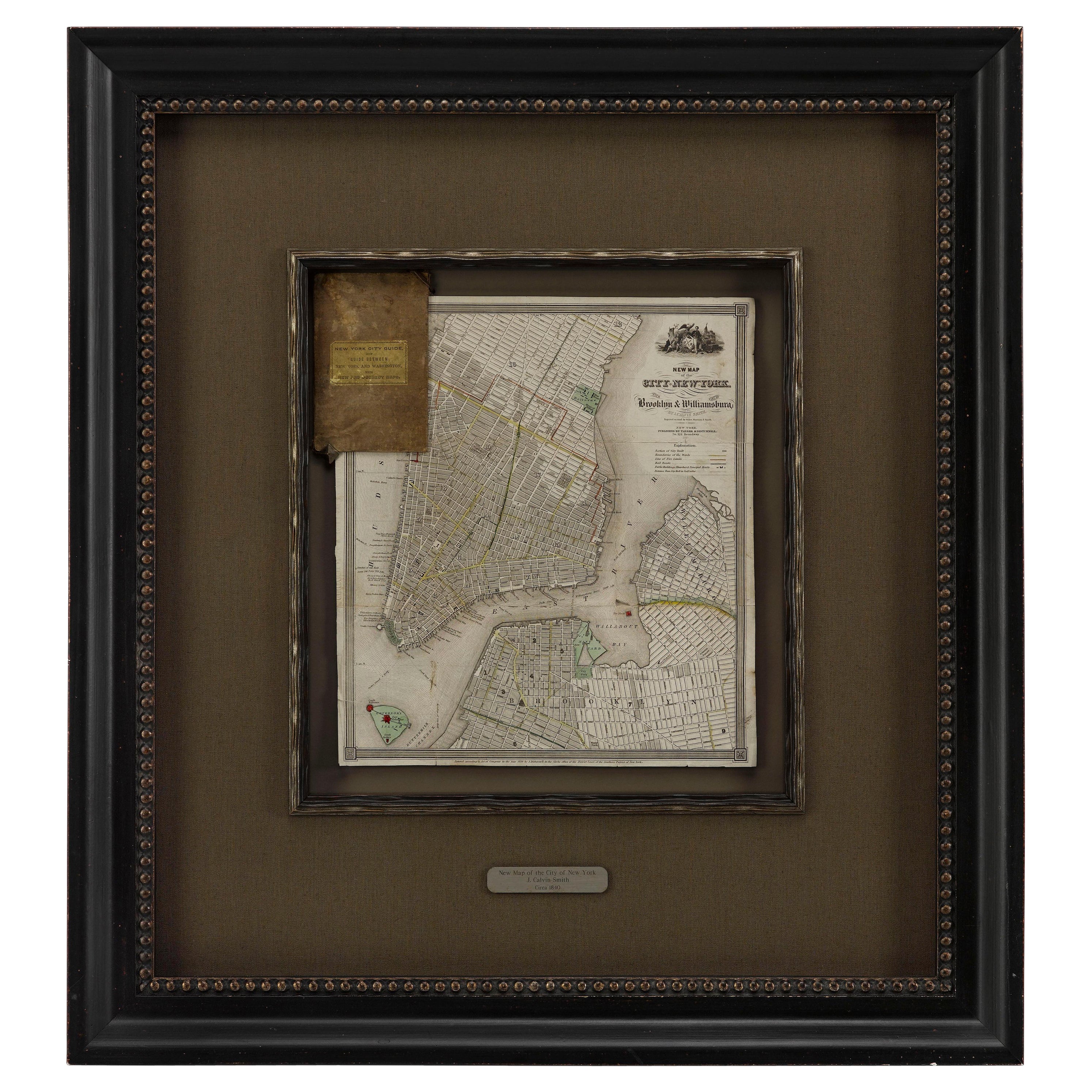
1840 "New Map of the City of New York With Part of Brooklyn & Williamsburg"
Located in Colorado Springs, CO
Presented is a hand-colored, engraved folding map titled "New Map of the City of New York With Part of Brooklyn & Williamsburg" by J. Calvin Smith. The map was issued bound in the bo...
Category
Antique 1840s American Maps
Materials
Paper

1912 "Panoramic View of New York City and Vicinity" by Jacob Ruppert
Located in Colorado Springs, CO
This is an attractive and very scarce map of New York, published by the Yorkville brewer Jacob Ruppert in 1912. The map shows an expansive view of the region reaching from Sandy Hook in the south and Yonkers to the north, to Hicksville in the east and past Newark to the west. This beautifully colored birds eye view shows waterways with all shipping traffic, boroughs, and clearly labeled railroad routes. It is presented on period dowels and backed on its original linen.
Jacob Ruppert was born in New York City in 1842 to Bavarian immigrants. His father owned a brewery in Manhattan where young Jacob learned the business of brewing. In 1862, Jacob established the Jacob...
Category
Vintage 1910s American Maps
Materials
Paper
1840 Map of the City of Washington Published by William M. Morrison
Located in Colorado Springs, CO
This map, printed in 1840, is a detailed representation of Washington, D.C. in the mid-19th century. The map shows block numbers, wards, and government buildings as well as details o...
Category
Antique 1840s American Federal Maps
Materials
Paper

1863 "Lloyd's New Map of the United States, the Canadas, and New Brunswick"
Located in Colorado Springs, CO
Presented is “Lloyd's New Map of the United States, the Canadas and New Brunswick, From the latest Surveys, Showing Every Railroad & Station Finished to June 1863, and the Atlantic and Gulf Coasts.” A large, Civil War-era hanging map of the United States and adjacent territories, this map covers the area from the Atlantic Ocean and extends as far west as the 103 meridian, to “Dacotah,” Nebraska, Kansas, "Indian Territory," and Texas. The southern continuation of Florida is shown in an inset map along the right margin. This map was published by J. T. Lloyd, in New York, in 1863. According to the publisher’s marking at lower right, this map was originally issued in two states: "in Sheets, Colored" for 50 cents, and "Varnished nicely, with Rollers" for $1.
Throughout the map, the counties are colored and the towns and cities well labeled. A reference key in the bottom margin provides symbols for railroads, turnpikes and wagon roads, state capitals, cities and towns, and village post offices. As emphasized in the map’s title, this map is especially notable for the countless railway lines and stations depicted, with distances noted between points, listing “every railroad and finished station to June 1863.” Additionally, two shipping agents and their routes are drawn out of New York City. The map includes details of the steamship routes into New York and Philadelphia from Liverpool and on to California and Oregon via an overland Nicaraguan trek, presumably to assist gold rush emigrants.
This expansive and impressive map depicts the eastern half of the United States in the third year of the Civil War. In order not to recognize the legitimacy of the Confederate States of America, each state is shown in the same manner as the Union states. The only indication that the American Civil War was in progress when this map was published is a printed notice that Gideon Wells, Secretary of the Navy, wishes to acquire a quote on 100 copies of Lloyd’s Mississippi River map...
Category
Antique 1860s American Maps
Materials
Linen, Wood, Paper

1907 Map of Colorado, Antique Topographical Map, by Louis Nell
Located in Colorado Springs, CO
This highly detailed pocket map is a topographical map of the state of Colorado by Louis Nell from 1907. The map "has been complied from all availabl...
Category
Antique Early 1900s American Maps
Materials
Paper

You May Also Like
Vintage Oversized New York City Lower Manhattan 1840s Map Print
Located in Dayton, OH
Vintage late 20th century reproduction print of New York City featuring lower Manhattan in 1840.
Category
Late 20th Century Victorian Maps
Materials
Paper

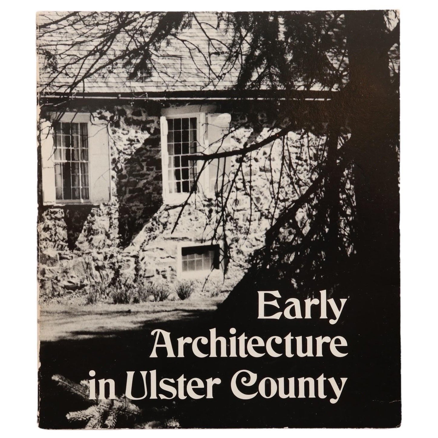
Early Architecture in Ulster County, New York
Located in Bradenton, FL
Early Architecture in Ulster County, New York. Softcover book published in 1974 by the Junior League of Kingston. Illustrated, 222 pages.
Category
Vintage 1970s American Books
Materials
Paper
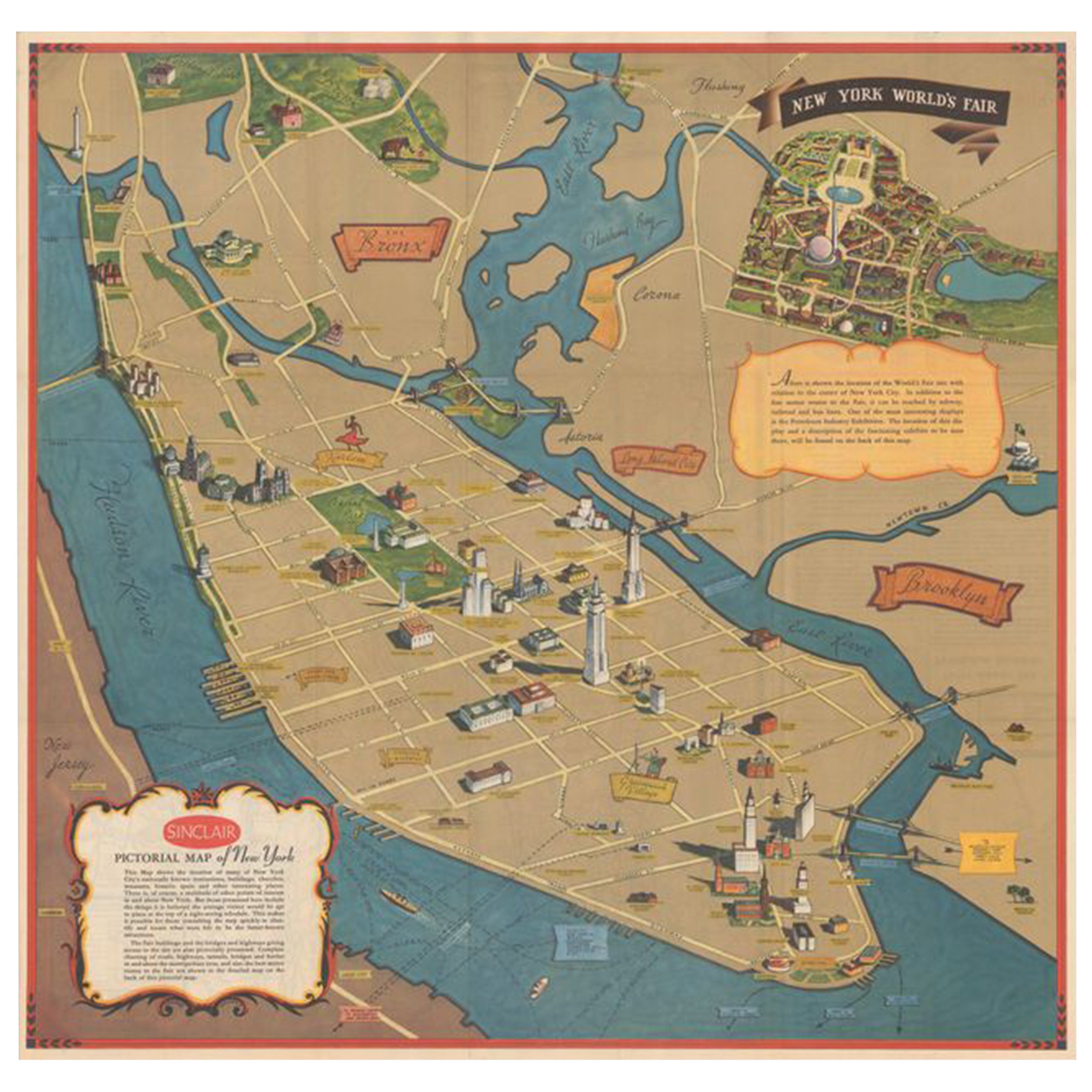
Pictorial Vintage Map of New York City Showing Numerous Landmarks, 1939
Located in Langweer, NL
This pictorial souvenir map focuses on New York City and the site of the 1939 World's Fair. It was drawn by graphic artist George Annand and published by Sinclair Oil...
Category
Vintage 1930s Maps
Materials
Paper

$470 Sale Price
24% Off
Antique Map of New York by Johnson '1872'
Located in Langweer, NL
Antique map titled 'Johnson's New York'. Original map showing New York, with an inset map of Long Island. This map originates from 'Johnson's New Il...
Category
Antique Late 19th Century Maps
Materials
Paper

New York Nude, a Photographic Essay by Charles R. Collum
By Charles R. Collum
Located in valatie, NY
New York Nude, a photographic essay by Charles R. Collum. NY: Watson-Guptill publications. First edition hardcover with dust jacket, 1981. 128 pp. A collection of nude portraits capt...
Category
20th Century American Books
Materials
Paper
18th Century Emanuel Bowen Map of County of York, c.1740
By Emanuel Bowen
Located in Royal Tunbridge Wells, Kent
Antique 18th century British rare and original Emanuel Bowen (1694-1767) map of the County of York divided into its Ridings and subdivided into wapontakes, mounted in solid wood fram...
Category
Antique Early 18th Century British Maps
Materials
Paper

Recently Viewed
View AllMore Ways To Browse
Used Modern Furniture New York
City Used Office Furniture
New York City Used Furniture
Used Furniture In New York City
New York City Mid Century Modern Furniture
Antique Furniture New York City
Folding Maps
Antique City Map
Antique City Maps
United States Map
Beautiful Map
The United States Map
New Jersey Furniture
Used Furniture Brooklyn New York
Antique City Plans
Framed Map
Antique Map Framing
Antique Maps Framed