Items Similar to 1864 Map of North America, Antique Hand-Colored Map, by Adolphe Hippolyte Dufour


Video Loading
Want more images or videos?
Request additional images or videos from the seller
1 of 6
1864 Map of North America, Antique Hand-Colored Map, by Adolphe Hippolyte Dufour
About the Item
Offered is a map of North America entitled Amerique du Nord from 1864. This rare, separately published wall map was produced by Adolphe Hippolyte Dufour. This map includes vibrant and elaborate hand-coloring within country borders, as well as brightly colored lines representing state borders, which stand in stark contrast. The work is extremely detailed with labels of cities and rivers across the continent. The work is dissected into four separate sheets and is laid neatly on two sheets of linen. There are two stamps for the German Ministry of Foreign Affairs, which existed until the 1920s. This map has also appeared in Andriveau-Goujon's Atlas Choix.
This map covers an extensive amount of land in the North American continent. The work displays land from the Polar Ice cap to as far down as the northern edge of South America. The map includes an unusual view of the Transmississippi West, with a misshaped Texas, as well as Nebraska Territory, Kansas extending to the Rocky Mountains, Washington, and Oregon. New Mexico depicted is above Arizona (Baylor line) and the Territory of Shoshone is shown (pre-Idaho). Nevada's eastern border is nearly at the western edge of Salt Lake, an early effort to reduce the Mormon influence, although its eastern border is very odd. Nevada's lower tip, which would include Clark County (Las Vegas), is shown in Arizona. The map is very collectible due to its terrific early Western Territorial names and boundaries. This map provides a variety of detailed nautical routes, as well as an inset map at the lower left showing the edge of present day Alaska. The land of Alaska is labeled here as “Russian America,” relating to Russian colonial possessions in North America that lasted from 1733-1867.
Adolphe Hippolyte Dufour (1795-1865) was a French-based map and atlas publisher active in the middle to late 19th century, working primarily in Paris. Dufour was a student of Emile Lapie, another famous French cartographer, and has worked with numerous other cartographers to publish a wide array of maps and atlases. He is well known for his famous elephant folio entitled Atlas Universel physique, historique et politique geographie ancienne et moderne. Alexandre Vuillemin was Dufor’s student and ultimately his successor.
Condition:
Overall good condition considering age and use. Some significant soiling, specifically at right side, and some scattered foxing. Coloring is still quite vibrant. Stabilized on linen. 35 1/2" H x 24 1/3" W total sheet size. The map is framed according to the highest archival standards in an elegant black and gold frame.
Framed dimensions: 44 1/2" H x 33" W x 1 1/2" D.
- Dimensions:Height: 44.5 in (113.03 cm)Width: 33 in (83.82 cm)Depth: 1.5 in (3.81 cm)
- Materials and Techniques:
- Place of Origin:
- Period:
- Date of Manufacture:1864
- Condition:Additions or alterations made to the original: Stabilized on linen. Wear consistent with age and use. Minor fading. Overall good condition considering age and use. Some significant soiling, specifically at right side, and some scattered foxing. Coloring is still quite vibrant. Stabilized on linen.
- Seller Location:Colorado Springs, CO
- Reference Number:
About the Seller
4.9
Platinum Seller
These expertly vetted sellers are 1stDibs' most experienced sellers and are rated highest by our customers.
Established in 2010
1stDibs seller since 2011
402 sales on 1stDibs
Typical response time: <1 hour
- ShippingRetrieving quote...Ships From: Colorado Springs, CO
- Return PolicyA return for this item may be initiated within 10 days of delivery.
More From This SellerView All
- 1875 "North America" Map by J. BartholomewLocated in Colorado Springs, COPresented is an original 1875 map of “North America.” The map was issued in Volume 1 of the Ninth Edition of the Encyclopædia Britannica, published in Edinburgh. The map was drawn by famous Scottish mapmaker John Bartholomew. The map depicts North America, to include Greenland, the Dominion of Canada, the United States, Mexico, the countries of Central America, and the islands of the West Indies. Prominent rivers, mountain ranges, and cities are labeled on the map, and country borders are emphasized in red. The Encyclopædia Britannica has been published continuously since 1768, appearing in fifteen official editions. The landmark ninth edition of the Encyclopædia Britannica, often called "the Scholar's Edition," was published from January 1875 to 1889 in 25 volumes. The editor and author of the “Foreword” was Thomas Spencer Baynes, the first English-born editor after a series of Scots. After 1880, Baynes was assisted by William Robertson Smith. The 9th edition is often lauded as a high point among early editions for scholarship. The 9th edition was far more luxurious than any previously printed Encyclopædia Britannicas, with thick boards and quality leather bindings, premier paper, and a production which took full advantage of the technological advances of printing in the years between the 1850s and 1870s. The publishers took advantage of the new ability to print large graphic illustrations on the same pages as the text, as opposed to limiting illustrations to separate copper plate engravings. Although this technology had first been used in a primitive fashion the 7th edition, and to a much lesser extent in the 8th, in the 9th edition there were thousands of quality illustrations and maps set...Category
Antique 1870s Scottish Maps
MaterialsPaper
- 1847 “World at One View” Antique Hand-Colored Wall Map of the WorldLocated in Colorado Springs, COThis is a highly desirable hanging wall map of the "World at One View", published in 1847 by Ensign and Thayer, New York. This pictorial map was printed as a broadside and features...Category
Antique 19th Century American Maps
MaterialsPaper
- 1864 "Proclamation of Emancipation, " Antique Engraving by Charles ShoberLocated in Colorado Springs, COThis 1865 engraving features the Emancipation Proclamation in elaborate calligraphic text, with five patriotic vignettes and a small portrait...Category
Antique 1860s American Historical Memorabilia
MaterialsPaper
- 1907 Map of Colorado, Antique Topographical Map, by Louis NellLocated in Colorado Springs, COThis highly detailed pocket map is a topographical map of the state of Colorado by Louis Nell from 1907. The map "has been complied from all availabl...Category
Antique Early 1900s American Maps
MaterialsPaper
- 1859 "Map of the United States of America..." by J. H. ColtonBy J.H. ColtonLocated in Colorado Springs, COPresented is an 1859 “Map of the United States of America, the British Provinces, Mexico, the West Indies and Central America with Part of...Category
Antique 1850s American Maps
MaterialsPaper
- 1861 Topographical Map of the District of Columbia, by Boschke, Antique MapLocated in Colorado Springs, COPresented is an original map of Albert Boschke's extremely sought-after "Topographical Map of the District of Columbia Surveyed in the Years 1856 ...Category
Antique 1860s American Historical Memorabilia
MaterialsPaper


You May Also Like
- Antique Map of North America by Dufour 'circa 1834'Located in Langweer, NLAntique map titled 'Amérique Septentrionale'. Uncommon map of North America. Published by or after A.H. Dufour, circa 1834. Source unknown, to be determined.Category
Antique Mid-19th Century Maps
MaterialsPaper
- Antique Map of North America, 1821Located in Langweer, NLAntique map of America titled 'Carte de l'Amerique septentrionale'. Scarce map of North America, shortly after the Louisiana Purchase and the first ...Category
Antique 19th Century Maps
MaterialsPaper
- Antique Map of North America by Johnson, '1872'Located in Langweer, NLAntique map titled 'Johnson's North America'. Original map of North America, with an inset map of the Hawaiian group or Sandwich Islands. This map originates from 'Johnson's New Illu...Category
Antique Late 19th Century Maps
MaterialsPaper
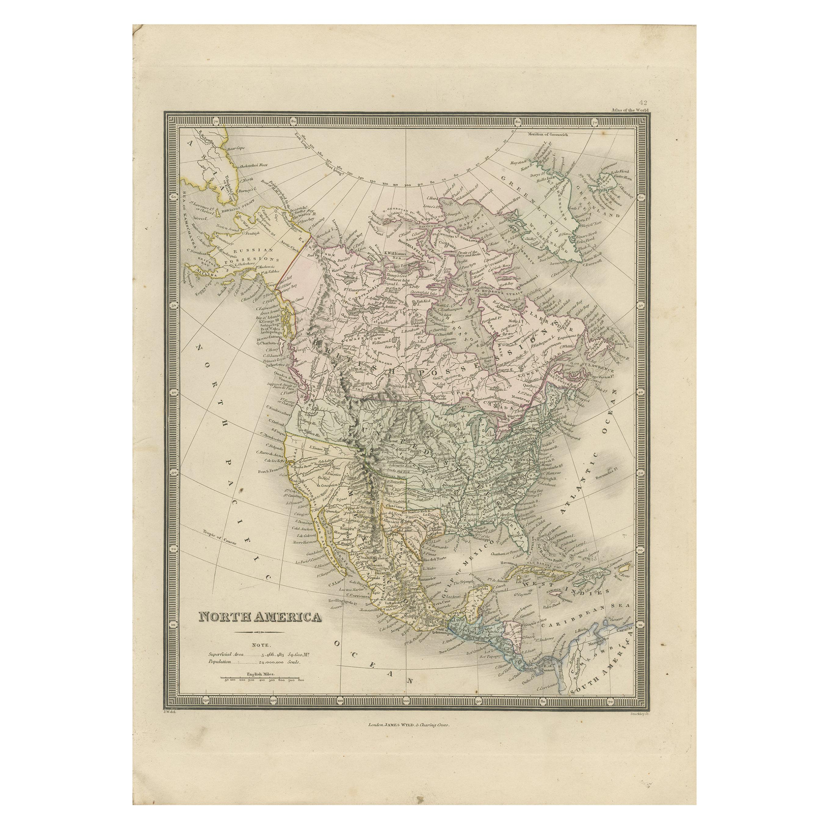
- Antique Map of North America by Wyld '1845'Located in Langweer, NLAntique map titled 'North America'. Original antique map of North America. This map originates from 'An Atlas of the World, Comprehending ...Category
Antique Mid-19th Century Maps
MaterialsPaper
- Antique Map of North America by Levasseur '1875'Located in Langweer, NLAntique map titled 'Carte générale de l'Amérique Septentrionale'. Large map of North America. This map originates from 'Atlas de Géographie Modern...Category
Antique Late 19th Century Maps
MaterialsPaper
- Antique Map of North America by Lapie '1842'Located in Langweer, NLAntique map titled 'Carte de l'Amérique septentrionale'. Map of North America, with an inset map of the Aleutian Islands. This map originates from 'Atlas universel de géographie anci...Category
Antique Mid-19th Century Maps
MaterialsPaper


