Items Similar to Antique Map of Asia including Arabia, 1806


Want more images or videos?
Request additional images or videos from the seller
1 of 5
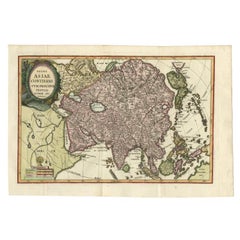
Antique Map of Asia including Arabia, 1806
About the Item
Antique map titled 'Asia'. Original antique map of the Asian continent engraved by E. Jones.
Artists and Engravers: Drawn under the direction of Mr. Arrowsmith. Published in 1806 by Longman.
Condition: Very good, please study image carefully.
Date: 1806
Overall size: 41.5 x 26.5 cm.
Image size: 30.5 x 25 cm.
We sell original antique maps to collectors, historians, educators and interior decorators all over the world. Our collection includes a wide range of authentic antique maps from the 16th to the 20th centuries. Buying and collecting antique maps is a tradition that goes back hundreds of years. Antique maps have proved a richly rewarding investment over the past decade, thanks to a growing appreciation of their unique historical appeal. Today the decorative qualities of antique maps are widely recognized by interior designers who appreciate their beauty and design flexibility. Depending on the individual map, presentation, and context, a rare or antique map can be modern, traditional, abstract, figurative, serious or whimsical. We offer a wide range of authentic antique maps for any budget.
- Dimensions:Height: 10.44 in (26.5 cm)Width: 16.34 in (41.5 cm)Depth: 0 in (0.01 mm)
- Materials and Techniques:
- Period:
- Date of Manufacture:1806
- Condition:
- Seller Location:Langweer, NL
- Reference Number:
About the Seller
5.0
Platinum Seller
These expertly vetted sellers are 1stDibs' most experienced sellers and are rated highest by our customers.
Established in 2009
1stDibs seller since 2017
1,947 sales on 1stDibs
Typical response time: <1 hour
- ShippingRetrieving quote...Ships From: Langweer, Netherlands
- Return PolicyA return for this item may be initiated within 14 days of delivery.
More From This SellerView All
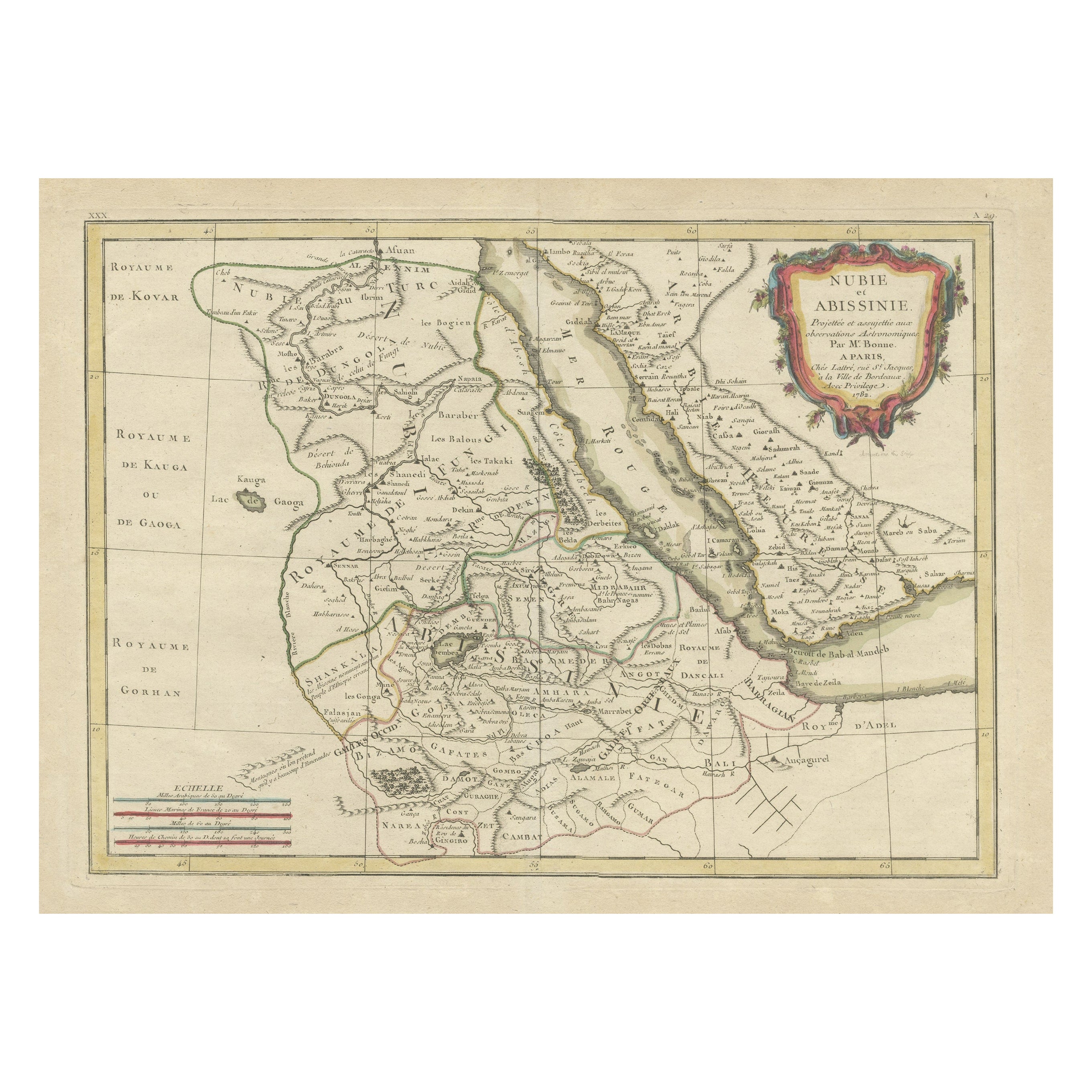
- Antique Map of Arabia including Nubia and Abyssinia, also shows the Red SeaLocated in Langweer, NLAntique map titled 'Nubie et Abissinie'. Original antique map of Nubia, a region along the Nile river, and Abyssinia or the Ethiopian Empire. This map o...Category
Antique Late 18th Century Maps
MaterialsPaper
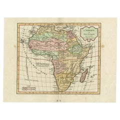
- Antique Map of Africa by Delamarche, 1806Located in Langweer, NLAntique map titled 'L'Afrique'. Decorative map of Africa by Robert de Vaugondy, revised and published by Delamarche. Source unknown, to be determined. Artists and Engravers: Charl...Category
Antique 19th Century Maps
MaterialsPaper
- Antique Map of Continental Asia, with Japan, Arabia, India, Russia, etc c.1702Located in Langweer, NLAntique map titled 'Totius Asiae Continens (..).' On this map of continental Asia and the adjacent islands Japan is shown with an oversized Terra Iedso (Hokkaido) connected with Honshu via a narrow isthmus. The Compagnie Land of the de Vries expedition is shown above, separated by a narrow strait named after the explorer. Nova Zembla is depicted correctly as an island, but the northeastern part of Siberia, the Chukchi peninsula and Kamchatka are missing. A portion of Australia is shown as Nova Hollandia...Category
Antique 18th Century Maps
MaterialsPaper
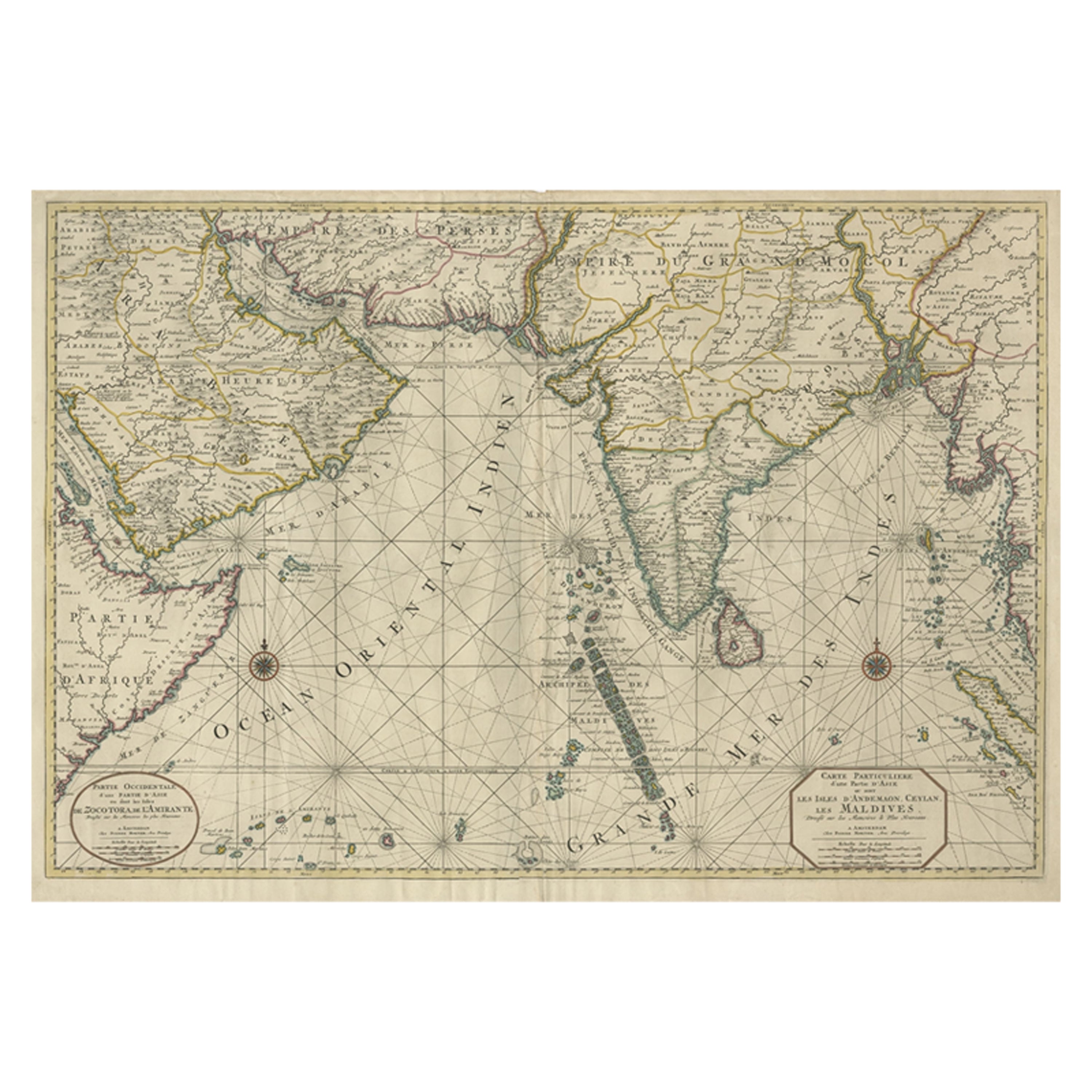
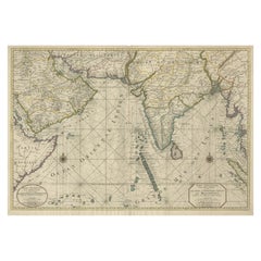
- Antique Map of Southern Asia with India, the Maldives, Ceylon and Arabia, c.1700Located in Langweer, NLStunning Old Map of Asia. Description: Two-sheet map of Asia, joined. The left part of this antique map is titled 'Partie occidentale d'une partie d'Asie ou sont les Isles de Zoco...Category
Antique Early 18th Century Maps
MaterialsPaper
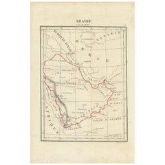
- Antique Map of Arabia by Tardieu '1843'Located in Langweer, NLAntique map titled 'Arabie'. Attractive small map of Arabia. This map originates from 'Dictionnaire Universel de Geographie Moderne' 4th Edition, by A.Pe...Category
Antique Mid-19th Century Maps
MaterialsPaper
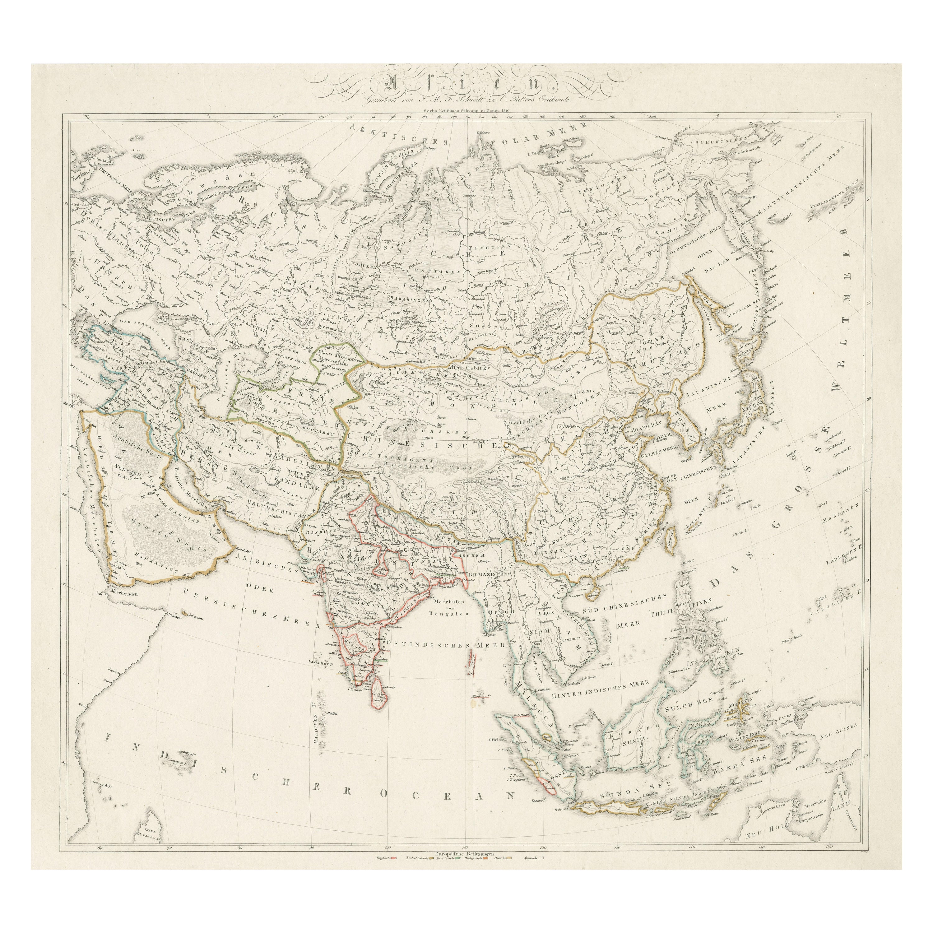
- Original Antique Map of AsiaLocated in Langweer, NLAntique map titled 'Asien'. Original old map of Asia. Published in Berlin by Simon Schropp et Comp, 1819.Category
Antique Early 19th Century Maps
MaterialsPaper

You May Also Like
- Original Antique Map of Sweden, Engraved by Barlow, 1806Located in St Annes, LancashireGreat map of Sweden Copper-plate engraving by Barlow Published by Brightly & Kinnersly, Bungay, Suffolk. 1806 Unframed.Category
Antique Early 1800s English Maps
MaterialsPaper
- Original Antique Map of Asia. C.1780Located in St Annes, LancashireGreat map of Asia Copper-plate engraving Published C.1780 Two small worm holes to right side of map Unframed.Category
Antique Early 1800s English Georgian Maps
MaterialsPaper

- Original Antique Map of Spain and Portugal, Engraved By Barlow, 1806Located in St Annes, LancashireGreat map of Spain And Portugal Copper-plate engraving by Barlow Published by Brightly & Kinnersly, Bungay, Suffolk. 1806 Unframed.Category
Antique Early 1800s English Maps
MaterialsPaper
- Original Antique Map of South East Asia, Arrowsmith, 1820Located in St Annes, LancashireGreat map of South East Asia Drawn under the direction of Arrowsmith Copper-plate engraving Published by Longman, Hurst, Rees, Orme and Brown, 1820 Unframed.Category
Antique 1820s English Maps
MaterialsPaper
- Original Antique Map of South East Asia by Becker, circa 1840Located in St Annes, LancashireGreat map of South East Asia Steel engraving with original color outline Engraved by Becker Published by Virtue, circa 1840. Unframed.Category
Antique 1840s English Other Maps
MaterialsPaper
- 18th Century Hand-Colored Homann Map of Germany, Including Frankfurt and BerlinBy Johann Baptist HomannLocated in Alamo, CAAn 18th century hand-colored map entitled "Tabula Marchionatus Brandenburgici et Ducatus Pomeraniae quae sunt Pars Septentrionalis Circuli Saxoniae Superioris" by Johann Baptist Homa...Category
Antique Early 18th Century German Maps
MaterialsPaper


