Items Similar to Antique Map of Asia Minor Showing Turkey in Ancient Times, 1880


Want more images or videos?
Request additional images or videos from the seller
1 of 5
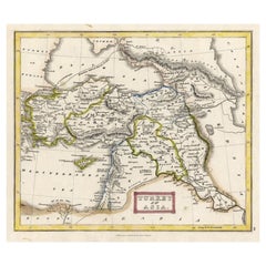
Antique Map of Asia Minor Showing Turkey in Ancient Times, 1880
About the Item
Map Pl. 9: 'Asie Mineure.' This map shows Asia Minor / Turkey in ancient times. This original antique map originates from 'Atlas de la Geographie Universelle ou Description de toutes les parties du monde sur un plan nouveau d'apres les grandes divisions naturelles du globe' by Malte-Brun and Huot. Published by P. Garnier in France, 1880. The lithographic maps are by Pierre Sarrazin.
Artists and Engravers: Conrad Malte-Brun (1755 - 1826), born Malthe Conrad Bruun, was a Danish-French geographer and journalist. His second son, Victor Adolphe Malte-Brun, was also a geographer.
Condition: Good. General age related toning and soiling. Please study image carefully.
Date: 1880
Overall size: 39 x 28 cm.
Image size: 0.001 x 29.5 x 22.5 cm.
- Dimensions:Height: 11.03 in (28 cm)Width: 15.36 in (39 cm)Depth: 0 in (0.01 mm)
- Materials and Techniques:
- Period:
- Date of Manufacture:1880
- Condition:
- Seller Location:Langweer, NL
- Reference Number:
About the Seller
5.0
Platinum Seller
These expertly vetted sellers are 1stDibs' most experienced sellers and are rated highest by our customers.
Established in 2009
1stDibs seller since 2017
1,940 sales on 1stDibs
Typical response time: <1 hour
- ShippingRetrieving quote...Ships From: Langweer, Netherlands
- Return PolicyA return for this item may be initiated within 14 days of delivery.
More From This SellerView All
- Antique Map of Turkey in Asia 'Asia Minor', 1841Located in Langweer, NLAntique map titled 'Turkey in Asia'. Original antique map of Asia Minor (Turkey). Source unknown, to be determined. Artists and Engravers: Published by O...Category
Antique 19th Century Maps
MaterialsPaper
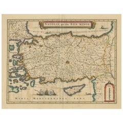
- Antique Map of Asia Minor, showing Turkey, Cyprus and the Islands in the AegeanLocated in Langweer, NLAntique map titled 'Natolia, quae olim Asia Minor'. Decorative map of Asia Minor, showing Turkey, Cyprus and the Islands in the Aegean. This attractive map shows all of Turkey, Cypru...Category
Antique Mid-17th Century Maps
MaterialsPaper
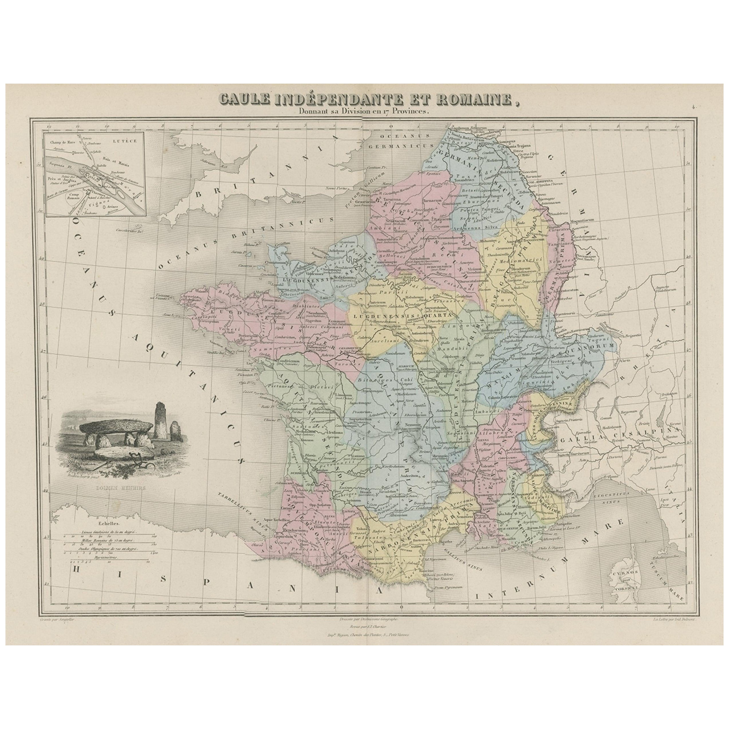
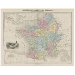
- Antique Map of France in Ancient Roman Times, 1880Located in Langweer, NLAntique map titled 'Gaule indépendante et Romaine'. Old map of Gaul or France in ancient Roman times. The map covers from the southern part of England (Britannia) to the north of S...Category
Antique 19th Century Maps
MaterialsPaper
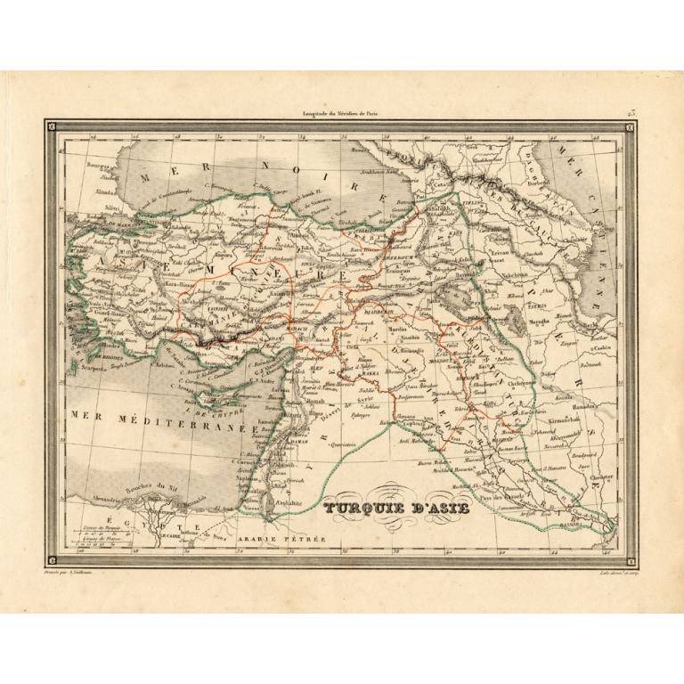
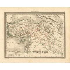
- Antique Map of Turkey in Asia 'Asia Minor' by Vuillemin, 1846Located in Langweer, NLAntique map titled 'Turqui D'Asie'. Map of Turkey in Asia / Asia Minor. This attractive original old antique print / plate / map originates from: 'Atlas Uni...Category
Antique 19th Century Maps
MaterialsPaper
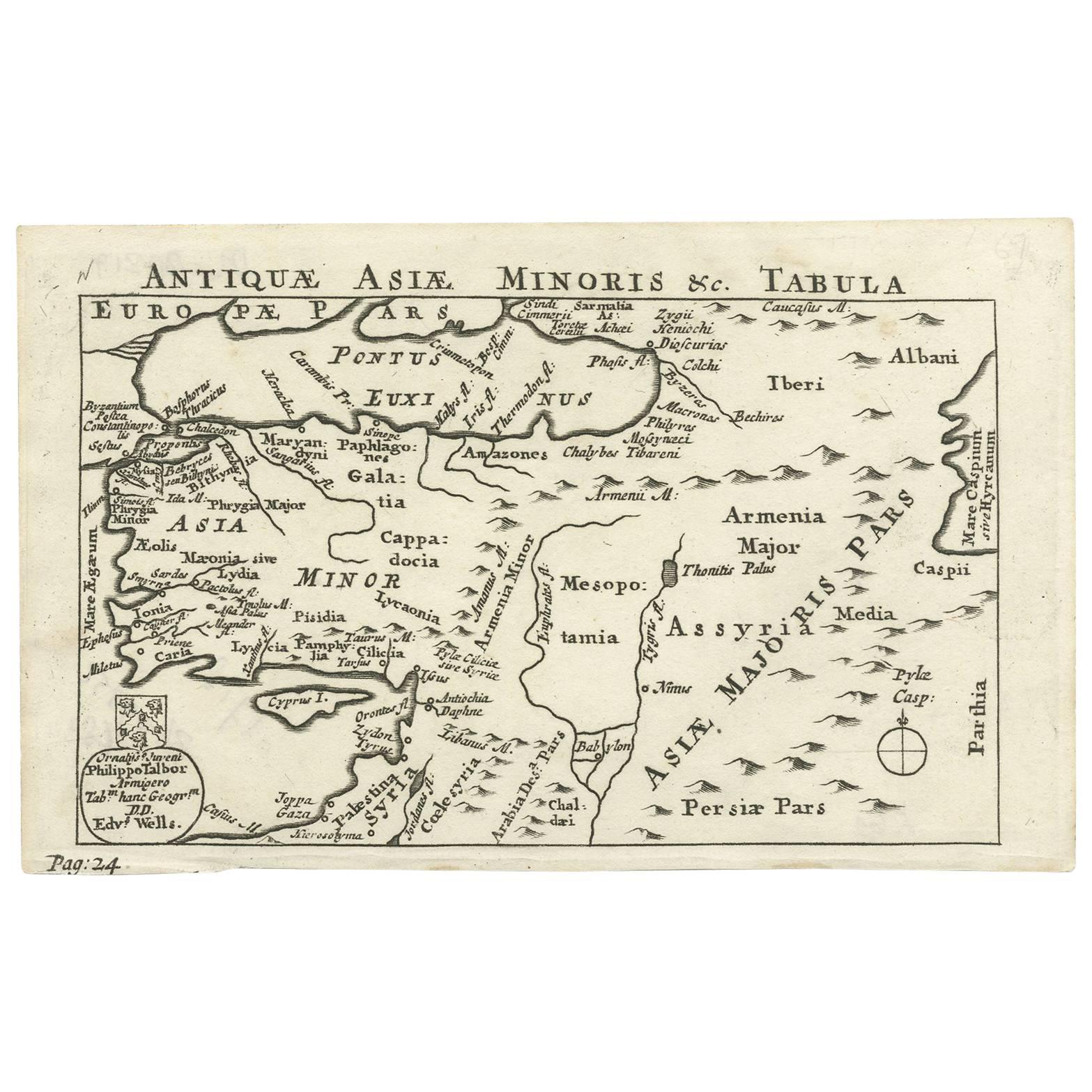
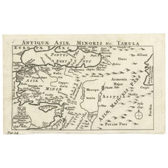
- Nice Antique Map of Asia Minor, Turkey, circa 1718Located in Langweer, NLAntique map titled 'Antiquae Asiae Minoris & C. Tabula' by Philippo Talbor. This rare antique map is published by Edward Wells, circa 1718.Category
Antique Early 18th Century Maps
MaterialsPaper
- Original Antique Map of Turkey, Asia Minor and CyprusBy Gerard MercatorLocated in Langweer, NLAntique map titled 'Natoliae sive Asia Minor'. Original old map of Turkey, Asia Minor and Cyprus. Includes a decorative cartouches, sailing ship, sea mon...Category
Antique Early 17th Century Maps
MaterialsPaper

You May Also Like
- Hand-Colored 18th Century Homann Map of the Black Sea, Turkey and Asia MinorBy Johann Baptist HomannLocated in Alamo, CAAn attractive original early 18th century hand-colored map of the Black Sea and Turkey entitled "Carte de L'Asie Minevre ou de la Natolie et du Pont Evxin Tiree des Voyages et des Ob...Category
Antique Early 18th Century German Maps
MaterialsPaper
- Original Antique Map of Ancient Greece, Achaia, Corinth, 1786Located in St Annes, LancashireGreat map of Ancient Greece. Showing the region of Thessaly, including Mount Olympus Drawn by J.D. Barbie Du Bocage Copper plate engraving by P.F Tardieu Original hand color...Category
Antique 1780s French Other Maps
MaterialsPaper
- Original Antique Map of Ancient Greece- Boeotia, Thebes, 1787Located in St Annes, LancashireGreat map of Ancient Greece. Showing the region of Boeotia, including Thebes Drawn by J.D. Barbie Du Bocage Copper plate engraving by P.F T...Category
Antique 1780s French Other Maps
MaterialsPaper
- Original Antique Map of South East Asia, Arrowsmith, 1820Located in St Annes, LancashireGreat map of South East Asia Drawn under the direction of Arrowsmith Copper-plate engraving Published by Longman, Hurst, Rees, Orme and Brown, 1820 Unframed.Category
Antique 1820s English Maps
MaterialsPaper
- Original Antique Map of Ancient Greece, Phocis, Gulf of Corinth, 1787Located in St Annes, LancashireGreat map of Ancient Greece. Showing the region of Phocis, including the Gulf of Corinth Drawn by J.D. Barbie Du Bocage Copper plate engraving by P.F Tardieu Original hand c...Category
Antique 1780s French Other Maps
MaterialsPaper
- Large Original Antique Map of Asia by Sidney Hall, 1847Located in St Annes, LancashireGreat map of Asia Drawn and engraved by Sidney Hall Steel engraving Original colour outline Published by A & C Black. 1847 Unframed Free shippingCategory
Antique 1840s Scottish Maps
MaterialsPaper


