Items Similar to Antique Map of the Banda Islands by Commelin, 1646


Want more images or videos?
Request additional images or videos from the seller
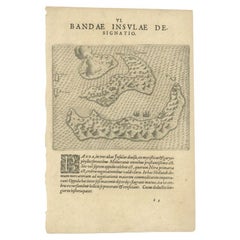
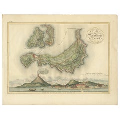
Antique Map of the Banda Islands by Commelin, 1646
About the Item
Plate 15: 'Afteeckeninge van 't Eyland Banda.' Depiction of the Banda Islands, Indonesia. Rare. This attrative plate originates from: 'Title: Waerachtigh verhael van de Schipvaerd op Oost-Indien Ghedaen by de acht Schepen in den jare 1598. van Amsterdam uyt-gezeylt, onder 't beleyd van den Admirael Jacob Cornelissoon van Neck, ende Vice-Admirael Wybrand van Warwijck..', which was part of the monumental work by Isaac Commelin (1598-1676) on VOC voyages: 'Begin ende voortgangh van de Vereenighde Nederlantsche Geoctroyeerde Oost-Indische Companie....', published by Joannes Janssonius, Amsterdam, 1646. Jacob Corneliszoon van Neck (1564-1638) was a Dutch naval officer and explorer, who led the second Dutch expedition to Indonesia (1598-99). The purpose of the expedition was to bring back spices, and was a huge success. Van Neck returned to Indonesia once more, but on that journey lost three fingers during a battle with a Spanish-Portuguese fleet. This prompted him to retire from exploration and travel. He later became mayor of Amsterdam, alderman and member of two admiralty colleges. (Ref: *Tiele 81; *Landwehr, VOC, 250.) Artists and Engravers: Casparus Commelin (1636-1693), publisher and bookseller in Amsterdam. Engraver/etcher unknown.
Artist: Casparus Commelin (1636-1693), publisher and bookseller in Amsterdam. Engraver/etcher unknown.
Condition: Good, given age. General age related toning and light staining. Please study scan carefully.
Date: 1646
Overall size: 23 x 17.5 cm.
Image size: 0.001 x 20 x 14 cm.
Antique prints have long been appreciated for both their aesthetic and investment value. They were the product of engraved, etched or lithographed plates. These plates were handmade out of wood or metal, which required an incredible level of skill, patience and craftsmanship. Whether you have a house with Victorian furniture or more contemporary decor an old engraving can enhance your living space. We offer a wide range of authentic antique prints for any budget.
- Dimensions:Height: 6.89 in (17.5 cm)Width: 9.06 in (23 cm)Depth: 0 in (0.01 mm)
- Materials and Techniques:
- Period:
- Date of Manufacture:1646
- Condition:
- Seller Location:Langweer, NL
- Reference Number:
About the Seller
5.0
Platinum Seller
These expertly vetted sellers are 1stDibs' most experienced sellers and are rated highest by our customers.
Established in 2009
1stDibs seller since 2017
1,950 sales on 1stDibs
Typical response time: <1 hour
- ShippingRetrieving quote...Ships From: Langweer, Netherlands
- Return PolicyA return for this item may be initiated within 14 days of delivery.
More From This SellerView All
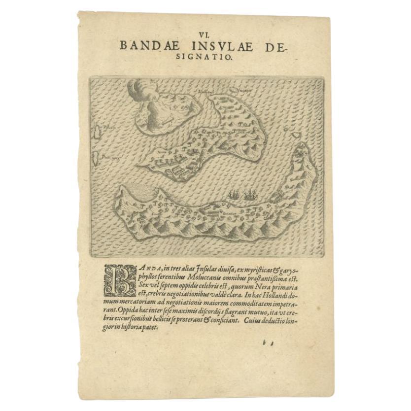
- Antique Map of the Banda Islands by De Bry, c.1600Located in Langweer, NLAntique map Indonesia titled 'Bandae Insulae designatio'. Antique map depicting the Banda Islands, Indonesia. With Latin text, blank verso. Orig...Category
Antique 17th Century Maps
MaterialsPaper
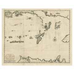
- Antique Map of the Banda Islands in Indonesia by Valentijn, 1726Located in Langweer, NLAntique map Indonesia titled 'Kaart der Zuyd-Wester Eylanden van Banda'. Map of the islands in the southwestern part of the Banda Sea including ...Category
Antique Mid-18th Century Maps
MaterialsPaper
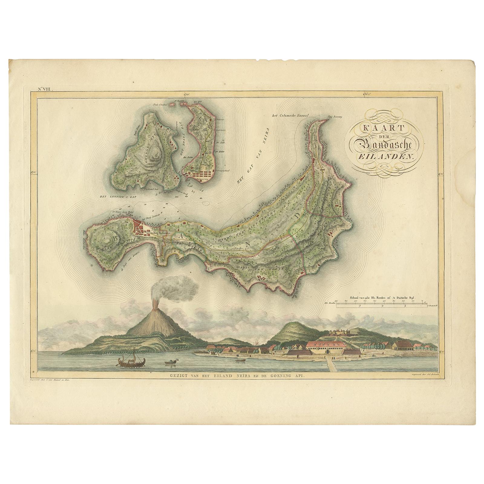
- Antique Map of the Banda Islands by Van den Bosch '1818'Located in Langweer, NLAntique map titled 'Kaart der Bandasche Eilanden'. Rare and attractive map of the Banda Islands with a large view of Banda Neira and Gunung Api. One of 12 maps from 'Atlas van Overze...Category
Antique Early 19th Century Maps
MaterialsPaper
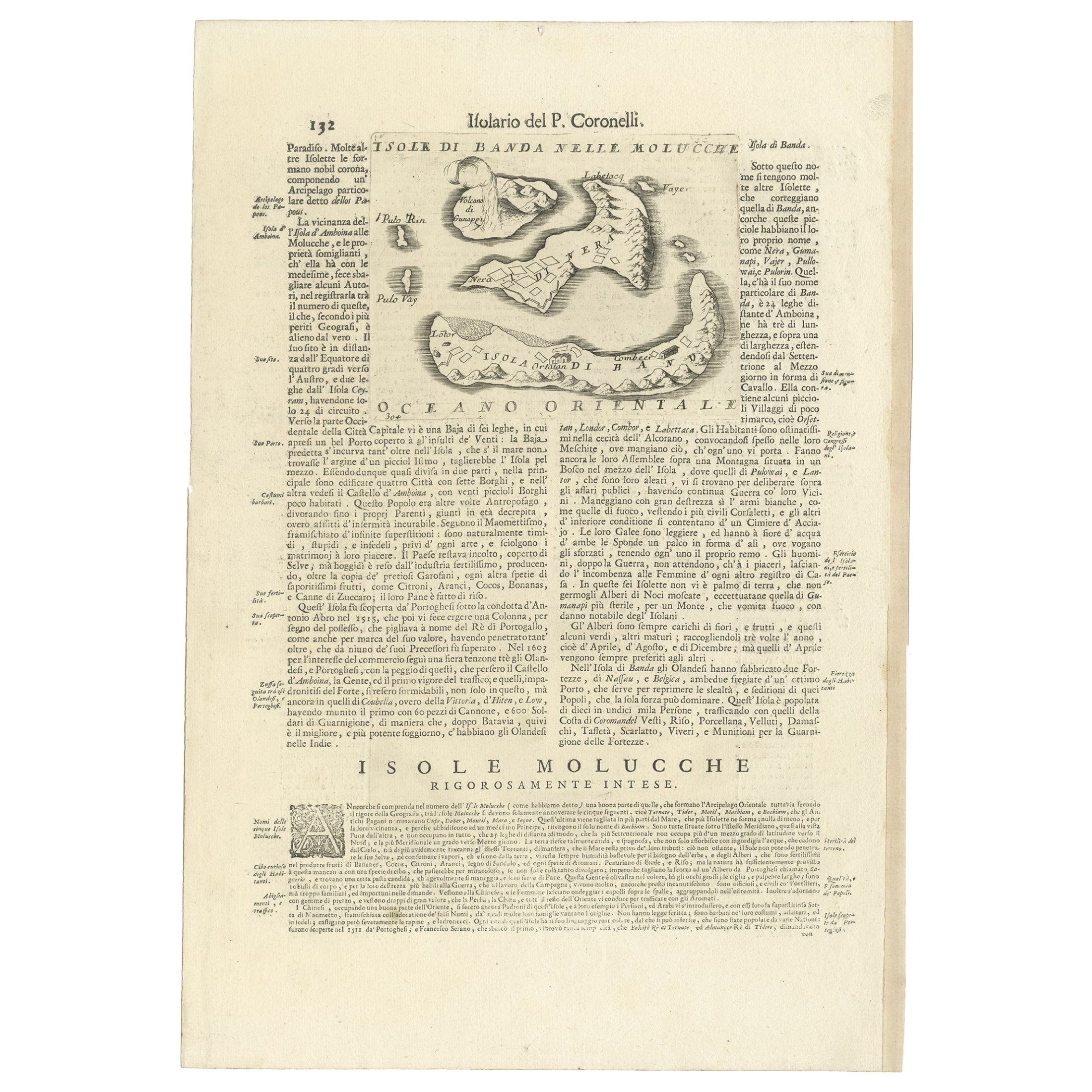
- Antique Map of the Banda Islands or Spice Islands, Moluccas, Indonesia, 1697Located in Langweer, NLAntique map titled 'Isole di Banda Nelle Molucche'. Engraved map of Isola di Banda, Nelle, Molucche. On verso: 'Isola di Solor'. Artists and Engravers: Vincenzo Maria (Padre)...Category
Antique 17th Century Maps
MaterialsPaper
- Old Antique Map of the Banda Islands (Southeast), Indonesia & Northern AustraliaBy F. ValentijnLocated in Langweer, NLOriginal antique map titled 'Kaart van de Zuyd-Ooster Eylanden van Banda'. Important map of the seas and islands surrounding the Banda Islands, Indonesia, extending south to northern Australia, east to Papua New Guinea and north to Ceram. Published 1724-1726 by Joannes van Braam...Category
Antique Early 18th Century Maps
MaterialsPaper
- Original Antique Map Southeast of the Banda or Spice Islands, Indonesia, 1726Located in Langweer, NLAntique map titled 'Kaart van de Zuyd-Ooster Eylanden van Banda'. Map of the southeastern part of the Banda islands. This map originates from 'Oud en Nieuw Oost-Indiën' by F. Valen...Category
Antique 1720s Maps
MaterialsPaper


You May Also Like
- 1646 Jansson Map Entitled "Procinvia Connactiae, " Ric.a006Located in Norton, MA1646 Jansson map entitled "Procinvia connactiae," Ric.a006 Description: The PROVINCE of CONNAVGT 490 x 380From vol 4 of Jansson's Atlas Novus 1646, published in Amsterdam with...Category
Antique 17th Century Unknown Maps
MaterialsPaper
- 1854 Map of Massachusetts, Connecticut and Rhode Island, Antique Wall MapLocated in Colorado Springs, COThis striking wall map was published in 1854 by Ensign, Bridgman & Fanning and has both full original hand-coloring and original hardware. This impression is both informative and highly decorative. The states are divided into counties, outlined in red, green, and black, and subdivided into towns. Roads, canals, and railroad lines are prominently depicted, although they are not all labeled. The mapmakers also marked lighthouses, banks, churches, and prominent buildings, with a key at right. The map is an informative and comprehensive overview of the infrastructural development of New England prior to the Civil War. Physical geographies depicted include elevation, conveyed with hachure marks, rivers and lakes. The impression features an inset map of Boston...Category
Antique 19th Century American Maps
MaterialsPaper
- Large Original Antique Map of Rhode Island, USA, C.1900Located in St Annes, LancashireFabulous map of Rhode Island Original color Engraved and printed by the George F. Cram Company, Indianapolis. Published, C.1900 Unframed Free ...Category
Antique 1890s American Maps
MaterialsPaper
- 1861 Topographical Map of the District of Columbia, by Boschke, Antique MapLocated in Colorado Springs, COPresented is an original map of Albert Boschke's extremely sought-after "Topographical Map of the District of Columbia Surveyed in the Years 1856 ...Category
Antique 1860s American Historical Memorabilia
MaterialsPaper
- Large Original Vintage Map of The Pacific Islands Including HawaiiLocated in St Annes, LancashireGreat map of The Pacific Islands Unframed Original color By John Bartholomew and Co. Edinburgh Geographical Institute Published, circa 1...Category
Vintage 1920s British Maps
MaterialsPaper
- 1868 Map of the Upper Part of the Island of Manhattan Above 86th StreetBy Wm. Rogers Mfg. Co.Located in San Francisco, CAThis wonderful piece of New York City history is over 150 years old. It depicts 86th street and above. It was lithographed by WC Rogers and company. It was made to show what was the Battle of Harlem during the Revolutionary war...Category
Antique 1860s American American Colonial Maps
MaterialsPaper


Recently Viewed
View AllMore Ways To Browse
Antique Island Furniture
Long Island Furniture
Old Wood Island
Antique Wood Island
Long Island Artists
Antique Vice
Van Neck
Jacobs Antique
Jacob Amsterdam
Antique Dutch Light
Spanish Antiques 17th Century
Antique Finger Plates
Antique Finger Plate
Antique Two Tone Light
Fleet Furniture Antique
Portugal 17th
Mayor Of Antique
Antique Spanish Plates