Items Similar to Antique Map of The Bay of D'Estaing located on the Russian island Sakhalin, 1798

Want more images or videos?
Request additional images or videos from the seller
Antique Map of The Bay of D'Estaing located on the Russian island Sakhalin, 1798
About the Item
Antique map titled 'Plan of La Baie d'Estaing'.
This map shows the bay of D'Estaing located on the Russian island of Sakhalin. La Perouse was selected by King Louis XVI to complete Captain James Cook's exploration of the western Pacific. Jean-Francois de Galaup & Comte de La Perouse commanded a French scientific expedition which set sail from France in 1785. The Boussole & Astrolabe with all aboard was shipwrecked in 1788 but the narrative, maps, and views survived and were published in 1797. La Perouse explored the coasts of the Gulf of Alaska and northwestern North America in search of the fabled Northwest Passage. After leaving America his expedition continued across the Pacific to Asia.
Artists and Engravers: Published by G. G. & J. Robinson in 1798.
- Dimensions:Height: 16.34 in (41.5 cm)Width: 14.38 in (36.5 cm)Depth: 0 in (0.02 mm)
- Materials and Techniques:
- Period:1790-1799
- Date of Manufacture:1798
- Condition:Wear consistent with age and use. Condition: Very good, please study image carefully.
- Seller Location:Langweer, NL
- Reference Number:
About the Seller
5.0
Platinum Seller
These expertly vetted sellers are 1stDibs' most experienced sellers and are rated highest by our customers.
Established in 2009
1stDibs seller since 2017
1,953 sales on 1stDibs
Typical response time: <1 hour
- ShippingRetrieving quote...Ships From: Langweer, Netherlands
- Return PolicyA return for this item may be initiated within 14 days of delivery.
More From This SellerView All
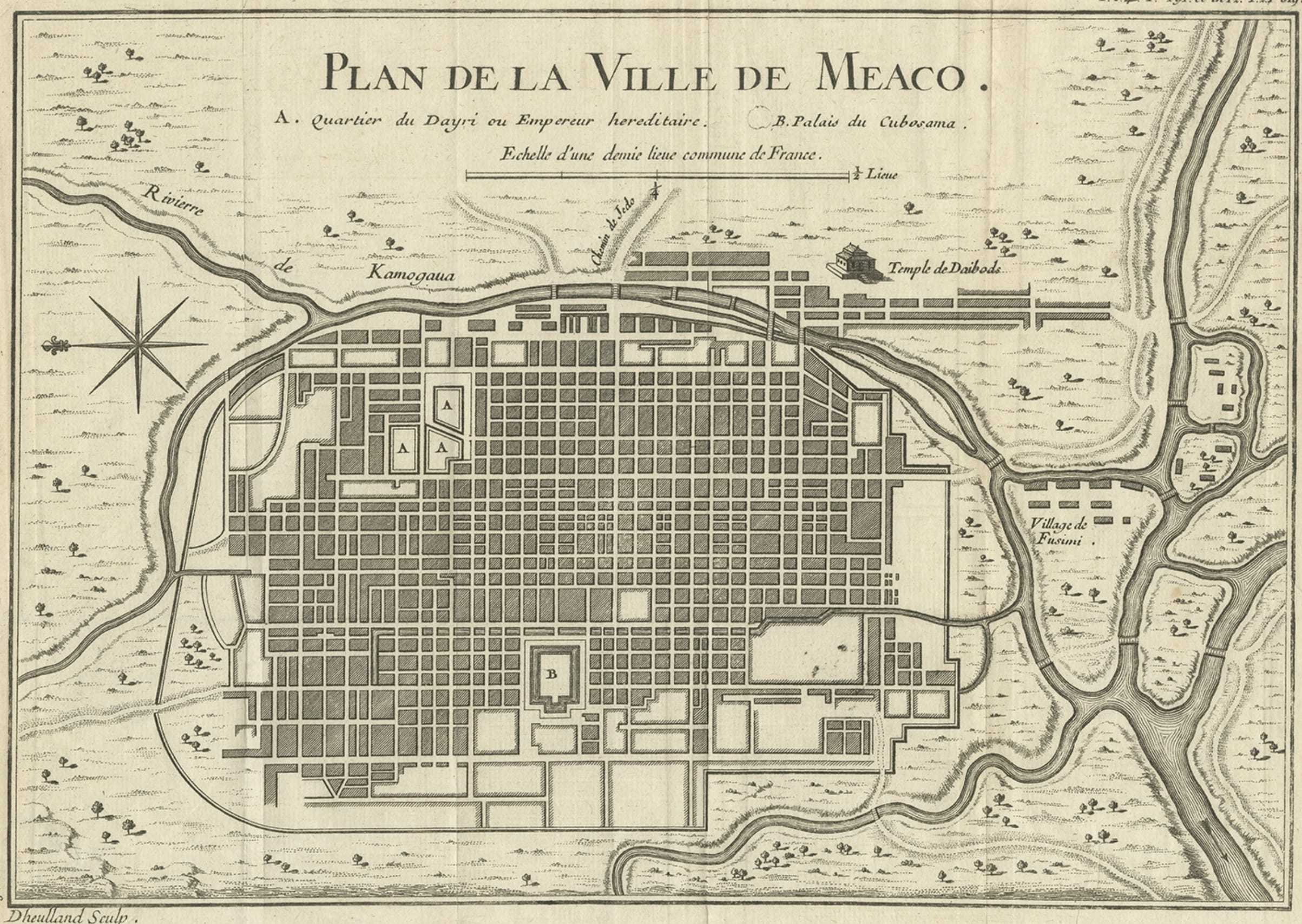
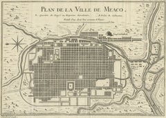
- Antique Map of Kyoto located in The Kansai Region on the Island of Honshu, c1740Located in Langweer, NLAntique map titled 'Plan de la Ville de Meaco'. Detailed plan of Kyoto, located in the Kansai region on the island of Honshu, Japan. This map most likely originates from an edition of 'Histoire et description generale du Japon' by P.F.X. de Charlevoix. Artists and Engravers: Jacques-Nicolas Bellin (1703-1772) was among the most important mapmakers of the eighteenth century. In 1721, at age 18, he was appointed hydrographer (chief cartographer) to the French Navy. In August 1741, he became the first Ingénieur de la Marine of the Depot des cartes...Category
Antique 18th Century Maps
MaterialsPaper
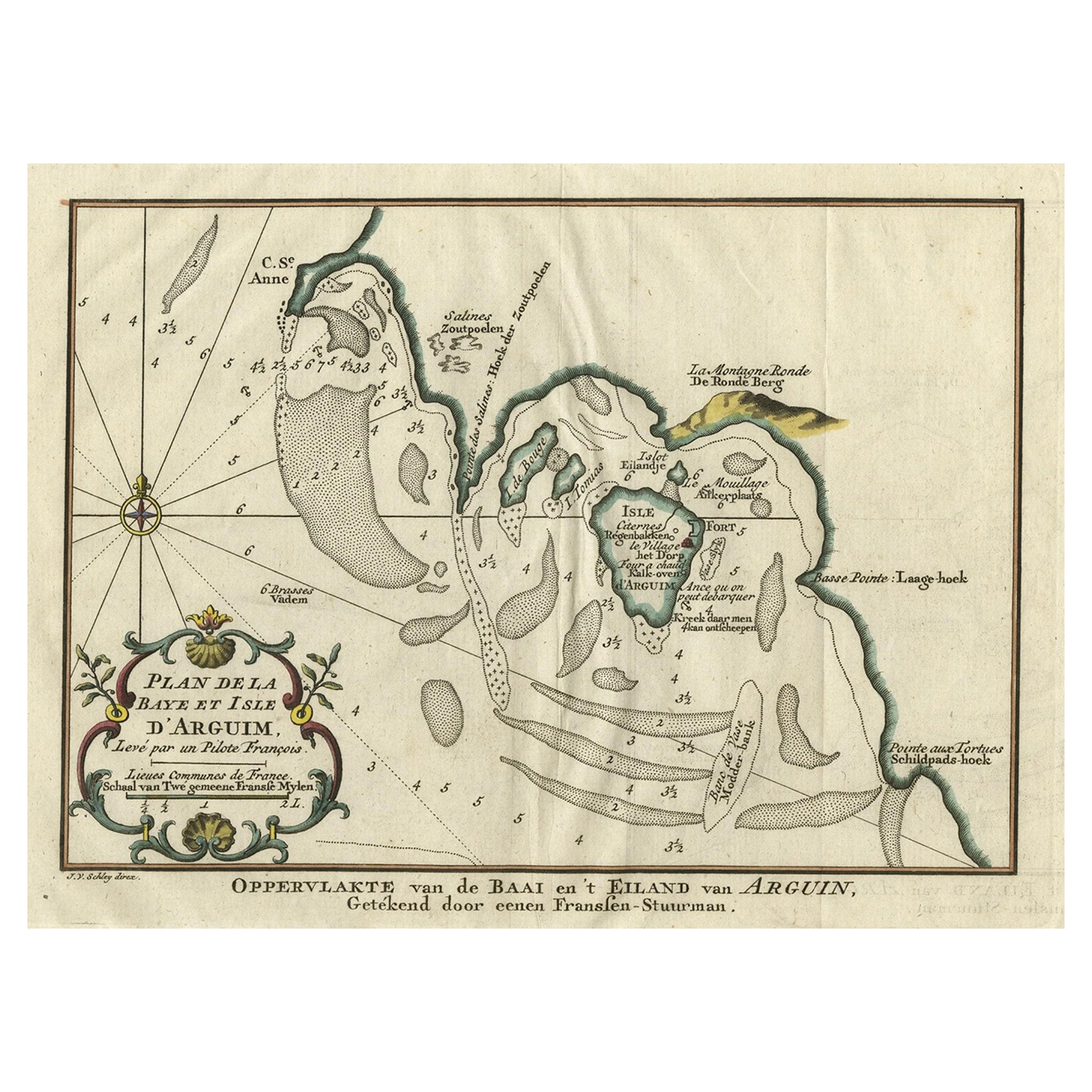
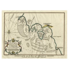
- Original Antique Map of the Bay and the Island of Arguin, Mauritania, 1747Located in Langweer, NLAntique map titled ’Plan de la Baye et Isle d'Arguim (..) - Oppervlakte van de Baai en 't Eiland van Arguin (..)'. Original antique map of the bay and the island of Arguin. This ...Category
Antique 1740s Maps
MaterialsPaper
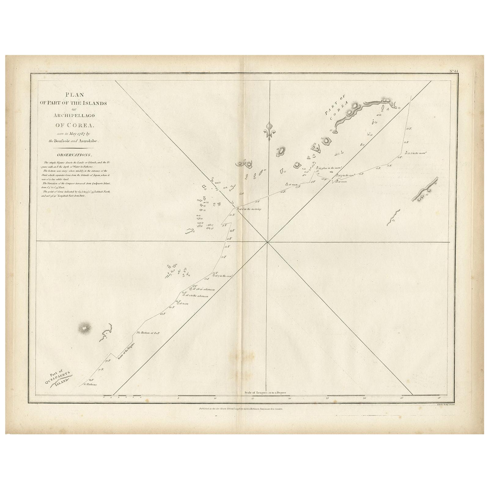
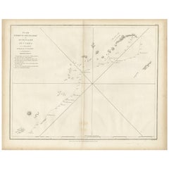
- Antique Map of Part of the Korean Archipelago, 1798Located in Langweer, NLAntique map titled 'Plan of Part of the Islands or Archipellago of Corea'. This map depicts part of the Korean Archipelago and originates from Charts and Plates to La Pérouse...Category
Antique Late 18th Century Maps
MaterialsPaper
- Antique Map of the Atlantic Islands, 1817Located in Langweer, NLAntique map titled 'Atlantic Islands'. Large map of the Atlantic Islands include the Cape Verde islands, Canary islands, Azore islands and Madeira islands. Also included a view of th...Category
Antique Early 19th Century Maps
MaterialsPaper
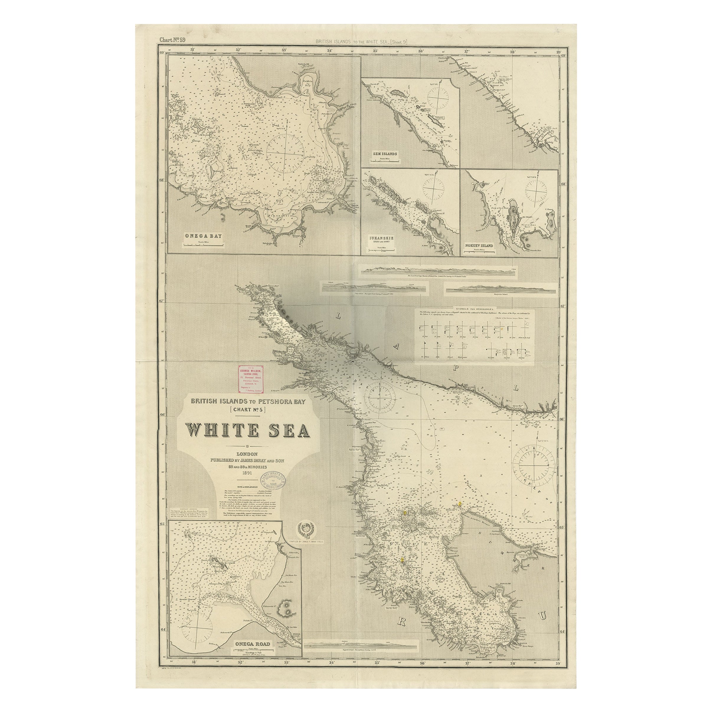
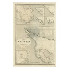
- Uncommon, Large Map of the British Islands to Petshora Bay, 1891Located in Langweer, NLAntique map titled 'British Islands to Petshora Bay - White Sea'. Uncommon, large map of the British Islands to Petshora Bay. It shows the White Sea and inse...Category
Antique 1890s Maps
MaterialsPaper
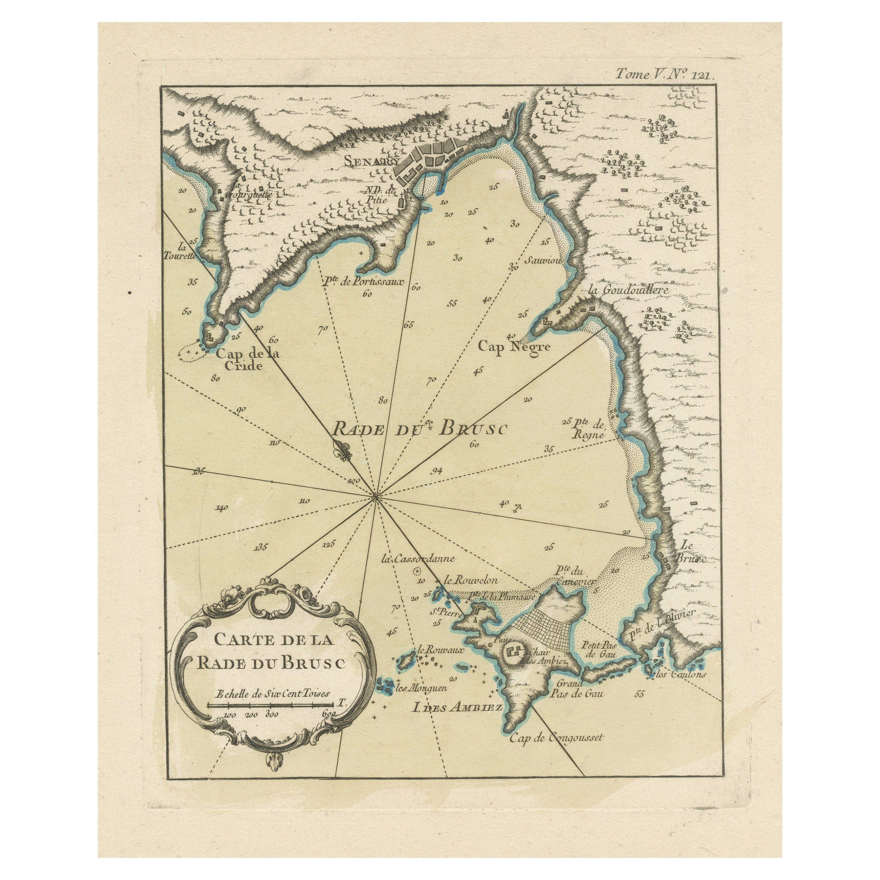
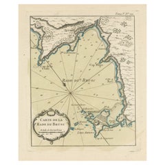
- Antique Map of the Bay of Brusc, FranceLocated in Langweer, NLAntique map titled 'Carte de la rade du Brusc'. Original map of the bay of Brusc, France. This map originates from 'Le Petit Atlas Maritime (..)' by J.N. Bellin. Published 1764. ...Category
Antique Mid-18th Century Maps
MaterialsPaper

You May Also Like
- Original Antique Map of Russia By Arrowsmith. 1820Located in St Annes, LancashireGreat map of Russia Drawn under the direction of Arrowsmith Copper-plate engraving Published by Longman, Hurst, Rees, Orme and Brown, 1820 Unframed.Category
Antique 1820s English Maps
MaterialsPaper
- Hand-Colored 18th Century Homann Map of Denmark and Islands in the Baltic SeaBy Johann Baptist HomannLocated in Alamo, CAAn 18th century copper plate hand-colored map entitled "Insulae Danicae in Mari Balthico Sitae utpote Zeelandia, Fionia, Langelandia, Lalandia, Falstria, Fembria Mona" created by Joh...Category
Antique Early 18th Century German Maps
MaterialsPaper
- Map of the Republic of GenoaLocated in New York, NYFramed antique hand-coloured map of the Republic of Genoa including the duchies of Mantua, Modena, and Parma. Europe, late 18th century. Dimension: 25...Category
Antique Late 18th Century European Maps
- Antique Map of Principality of MonacoBy Antonio Vallardi EditoreLocated in Alessandria, PiemonteST/619 - "Old Geographical Atlas of Italy - Topographic map of ex-Principality of Monaco" - ediz Vallardi - Milano - A somewhat special edition ---Category
Antique Late 19th Century Italian Other Prints
MaterialsPaper
- Original Antique Map of The World by Thomas Clerk, 1817Located in St Annes, LancashireGreat map of The Eastern and Western Hemispheres On 2 sheets Copper-plate engraving Drawn and engraved by Thomas Clerk, Edinburgh. Published by Mackenzie And Dent, 1817 ...Category
Antique 1810s English Maps
MaterialsPaper
- Antique 18th Century Map of the Province of Pensilvania 'Pennsylvania State'Located in Philadelphia, PAA fine antique of the colony of Pennsylvania. Noted at the top of the sheet as a 'Map of the province of Pensilvania'. This undated and anonymous map is thought to be from the Gentleman's Magazine, London, circa 1775, although the general appearance could date it to the 1760's. The southern boundary reflects the Mason-Dixon survey (1768), the western boundary is placed just west of Pittsburgh, and the northern boundary is not marked. The map has a number of reference points that likely refer to companion text and appear to be connected to boundaries. The western and southern boundaries are marked Q, R, S, for example. A diagonal line runs from the Susquehanna R to the Lake Erie P. A broken line marked by many letters A, B, N, O, etc., appears in the east. There are no latitude or longitude markings, blank verso. Framed in a shaped contemporary gilt wooden frame and matted under a cream colored matte. Bearing an old Graham Arader Gallery...Category
Antique 18th Century British American Colonial Maps
MaterialsPaper


Recently Viewed
View AllMore Ways To Browse
D Plan
French Antique Island
Bay Antique Furniture
Pacific Islands
Antique Bay
1790 America
French Map Of America
King Francois
Alaska Furniture
Shipwreck Antique
Antique Maps North America
Antique Map North America
Antique North America Map
North America Antique Map
Antique Maps Of North America
Shipwreck Furniture
G Robinson
Antique Russian Map