Items Similar to Antique Map of the Beaujolais Region by Homann Heirs, 1762


Want more images or videos?
Request additional images or videos from the seller
1 of 5
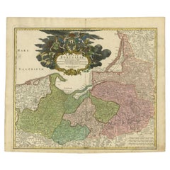
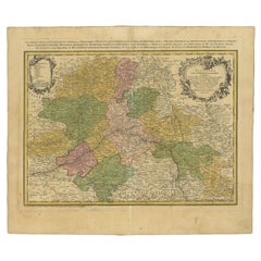
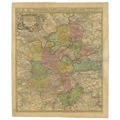
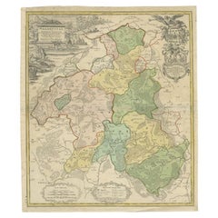
Antique Map of the Beaujolais Region by Homann Heirs, 1762
About the Item
Antique map titled 'La Generalite Proprie Taire De Lyon (..) - Propriae Lugudunensis Generalitatis (..)'. Detailed regional map of the Beaujolais region including the cities of Lyon, Clermont Ferrand, Roanne, Saint Etienne and Vienne. Fully engraved with mountains, forests and tiny villages. A decorative title cartouche incorporates a legend and distance scale. Artists and Engravers: Following the long period of Dutch domination, the Homann family became the most important map publishers in Germany in the eighteenth century, the business being founded by J.B. Homann in Nuremberg about the year 1702. Soon after publishing his first atlas in 1707 he became a member of the Berlin academy of Sciences and in 1715 he was appointed Geographer to the Emperor. After the founder's death in 1724, the firm was continued under the direction of his son until 1730 and was then bequeathed to his heirs on the condition that it trades under the name of Homann Heirs. The firm remained in being until the next century and had a wide influence on map publishing in Germany. Apart from the atlases the firm published a very large number of individual maps. The Homanns produced a Neuer Atlas in 1714, a Grosser Atlas in 1737, and an Atlas Maior with about 300 maps in 1780. They also issued a special Atlas of Germany with full sized plans of principal cities, school atlases and an Atlas of Silesia in 1750 with 20 maps.
Artist: Following the long period of Dutch domination, the Homann family became the most important map publishers in Germany in the eighteenth century, the business being founded by J.B. Homann in Nuremberg about the year 1702. Soon after publishing his first atlas in 1707 he became a member of the Berlin academy of Sciences and in 1715 he was appointed Geographer to the Emperor. After the founder's death in 1724, the firm was continued under the direction of his son until 1730 and was then bequeathed to his heirs on the condition that it trades under the name of Homann Heirs. The firm remained in being until the next century and had a wide influence on map publishing in Germany. Apart from the atlases the firm published a very large number of individual maps. The Homanns produced a Neuer Atlas in 1714, a Grosser Atlas in 1737, and an Atlas Maior with about 300 maps in 1780. They also issued a special Atlas of Germany with full sized plans of principal cities, school atlases and an Atlas of Silesia in 1750 with 20 maps.
Condition: Fair/good, general age-related toning. Large stain in the upper part of the map. Minor wear/defects. Blank verso. Please study image carefully.
Date: 1762
Overall size: 62 x 54 cm.
Image size: 0.001 x 55 x 44 cm.
Antique prints have long been appreciated for both their aesthetic and investment value. They were the product of engraved, etched or lithographed plates. These plates were handmade out of wood or metal, which required an incredible level of skill, patience and craftsmanship. Whether you have a house with Victorian furniture or more contemporary decor an old engraving can enhance your living space. We offer a wide range of authentic antique prints for any budget.
- Dimensions:Height: 21.26 in (54 cm)Width: 24.41 in (62 cm)Depth: 0 in (0.01 mm)
- Materials and Techniques:
- Period:
- Date of Manufacture:1762
- Condition:
- Seller Location:Langweer, NL
- Reference Number:
About the Seller
5.0
Platinum Seller
These expertly vetted sellers are 1stDibs' most experienced sellers and are rated highest by our customers.
Established in 2009
1stDibs seller since 2017
1,957 sales on 1stDibs
Typical response time: <1 hour
- ShippingRetrieving quote...Ships From: Langweer, Netherlands
- Return PolicyA return for this item may be initiated within 14 days of delivery.
More From This SellerView All
- Antique Map of the Baltic Region by Homann Heirs, c.1730Located in Langweer, NLAntique map titled 'Regnum Borussiae gloriosis auspicijs Seerenissimi et Potentissimi Princip Friderici III (..).' Detailed map of the Baltic region from Memel to Pomerania, extendin...Category
Antique 18th Century Maps
MaterialsPaper
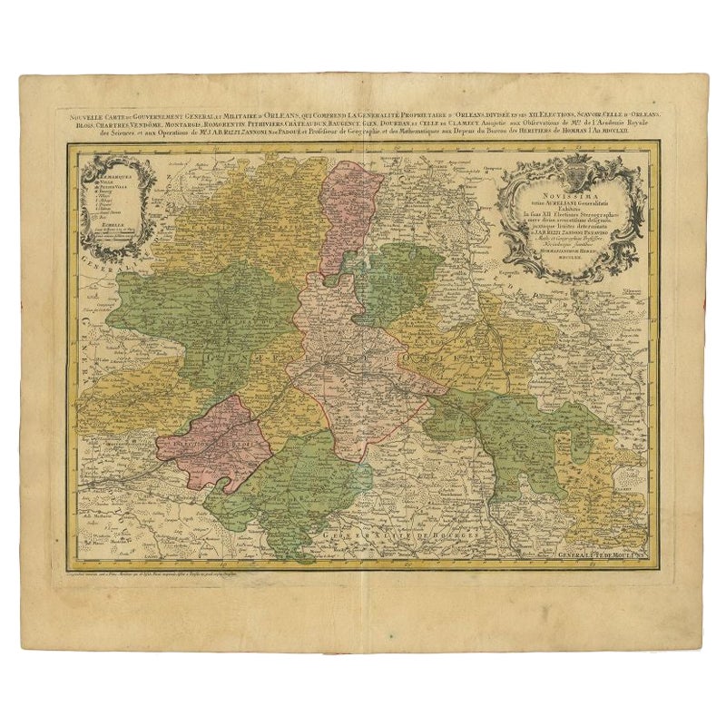
- Antique Map of the Region of Orleans by Homann Heirs, c.1760By Homann HeirsLocated in Langweer, NLAntique map titled 'Novissima Totius Aureliani Generalitatis (..) - Nouvelle Carte du Gouvernement General et Militaire d'Orleans (..).' Detailed map by Rizzi Zononi covering the vic...Category
Antique 18th Century Maps
MaterialsPaper
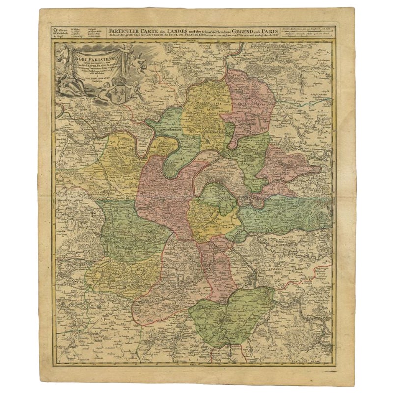
- Antique Map of the Region of Paris by Homann Heirs, c.1720By Homann HeirsLocated in Langweer, NLAntique map titled 'Agri Parisiensis Tabula particularis, qua maxima Pars Insulae Franciae (..).' Incredibly detailed map showing everything from tiny villages to forests, farmland, ...Category
Antique 18th Century Maps
MaterialsPaper
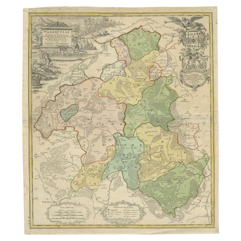
- Antique Map of the Waldeck Region of Germany by Homann Heirs, circa 1733By Homann HeirsLocated in Langweer, NLAntique map titled 'Waldecciae ac finitimorum Dominiorum (.)'. Map of the Waldeck region of Germany. With decorative cartouche depicting people mining, fishing and deer hunting with ...Category
Antique 18th Century Maps
MaterialsPaper
- Antique Map of Africa by Homann Heirs, '1804'Located in Langweer, NLAntique map titled 'Charte von Africa'. Large, original antique map of Africa by Franz Ludwig Güssefeld. Published by Homann Heirs, 1804.Category
Antique Early 19th Century Maps
MaterialsPaper
- Antique Map of France by Homann Heirs, c.1745Located in Langweer, NLAntique map titled 'Gallia Postarum geographice designata in qua Cursus Postarum Secundum Statum (..)'. Unusual postal map of France, with coat of arms. Very detailed map showing all...Category
Antique 18th Century Maps
MaterialsPaper


You May Also Like
- 1922 The HeirBy Vita Sackville-WestLocated in Bath, GBThe first edition of this novel with a lovely association, signed by the author and her mother to the politician Alfred Milner. The first edition, first impression. A presentation ...Category
Vintage 1920s British Books
MaterialsPaper
- Hand-Colored 18th Century Homann Map of the Danube, Italy, Greece, CroatiaBy Johann Baptist HomannLocated in Alamo, CA"Fluviorum in Europa principis Danubii" is a hand colored map of the region about the Danube river created by Johann Baptist Homann (1663-1724) in his 'Atlas Novus Terrarum', publish...Category
Antique Early 18th Century German Maps
MaterialsPaper
- Sweden & Adjacent Portions of Scandinavia: A Hand-Colored 18th C. Map by HomannBy Johann Baptist HomannLocated in Alamo, CAThis hand-colored map of Sweden and adjacent portions of Scandinavia entitled "Regni Sueciae in Omnes suas Subjacentes Provincias accurate divisi Tabula Generalis" was created by Joh...Category
Antique 1720s German Maps
MaterialsPaper
- 1861 Topographical Map of the District of Columbia, by Boschke, Antique MapLocated in Colorado Springs, COPresented is an original map of Albert Boschke's extremely sought-after "Topographical Map of the District of Columbia Surveyed in the Years 1856 ...Category
Antique 1860s American Historical Memorabilia
MaterialsPaper
- Hand Colored 18th Century Homann Map of Austria Including Vienna and the DanubeBy Johann Baptist HomannLocated in Alamo, CA"Archiducatus Austriae inferioris" is a hand colored map of Austria created by Johann Baptist Homann (1663-1724) and published in Nuremberg, Germany in 1728 shortly after his death. ...Category
Antique Early 18th Century German Maps
MaterialsPaper
- The Kingdom of Naples and Southern Italy: A Hand-Colored 18th Century Homann MapBy Johann Baptist HomannLocated in Alamo, CA"Novissima & exactissimus Totius Regni Neapolis Tabula Presentis Belli Satui Accommo Data" is a hand colored map of southern Italy and the ancient Kingdom of Naples created by Johann...Category
Antique Early 18th Century German Maps
MaterialsPaper


Recently Viewed
View AllMore Ways To Browse
Antique German Scales
Antique German Scale
Antique Science
Dutch School Antique
Large City Maps
18th Century Dutch School
Large Antique City Maps
Lyons Antique Prints
Map Berlin
Berlin Maps
Vienne Antique
Metal Plate Engraved B
Old School Maps
Tree Bag
16th Century Scotland
Great Britain Maps
Used Furniture Depot
World Map British