Items Similar to Antique Map of the Burmese Empire by Symes, '1800'


Want more images or videos?
Request additional images or videos from the seller
1 of 5
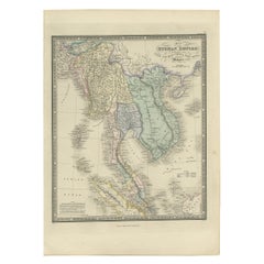
Antique Map of the Burmese Empire by Symes, '1800'
About the Item
Antique map titled 'Empire Birman d'après une carte'. Map of the Burmese Empire. This map originates from 'Relation de l'Ambassade Anglaise, envoyée en 1795 dans le Royaume d'Ava, ou l'Empire des Birmans' by M. Symes. Published 1800.
- Dimensions:Height: 11.82 in (30 cm)Width: 11.23 in (28.5 cm)Depth: 0.02 in (0.5 mm)
- Materials and Techniques:
- Period:
- Date of Manufacture:1800
- Condition:General age-related toning, original folding line. Minor wear, blank verso. Please study image carefully.
- Seller Location:Langweer, NL
- Reference Number:
About the Seller
5.0
Platinum Seller
These expertly vetted sellers are 1stDibs' most experienced sellers and are rated highest by our customers.
Established in 2009
1stDibs seller since 2017
1,940 sales on 1stDibs
Typical response time: <1 hour
- ShippingRetrieving quote...Ships From: Langweer, Netherlands
- Return PolicyA return for this item may be initiated within 14 days of delivery.
More From This SellerView All
- Antique Map of the Burmese Empire by Wyld, '1845'Located in Langweer, NLAntique map titled 'Map of Burman Empire, Siam, Cochin China and Ton-King'. Original antique map of the Burmese Empire. This map originates from 'An Atlas of the World, Comprehending...Category
Antique Mid-19th Century Maps
MaterialsPaper
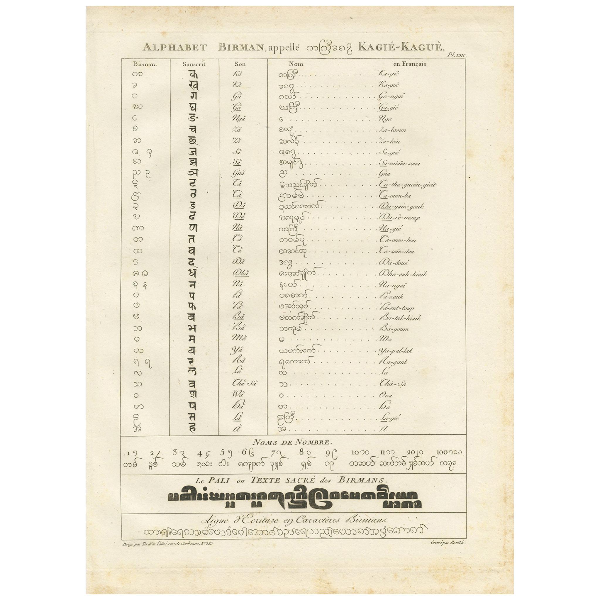
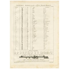
- Antique Print of the Burmese Alphabet by Symes, 1800Located in Langweer, NLAntique print titled 'Alphabet Birman'. Print of the Burmese alphabet. This print originates from 'Relation de l'Ambassade Anglaise, envoyée en 1795 dans le Royaume d'Ava, ou l'Empir...Category
Antique Early 19th Century Prints
MaterialsPaper
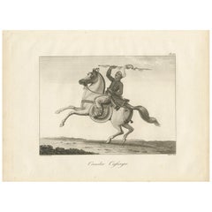
- Antique Print of a Burmese Warrior by Symes, 1800Located in Langweer, NLAntique print titled 'Cavalier Cassayer'. Print of a Burmese warrior. This print originates from 'Relation de l'Ambassade Anglaise, envoyée en 1795 dans le Royaume d'Ava, ou l'Empire...Category
Antique Early 19th Century Prints
MaterialsPaper
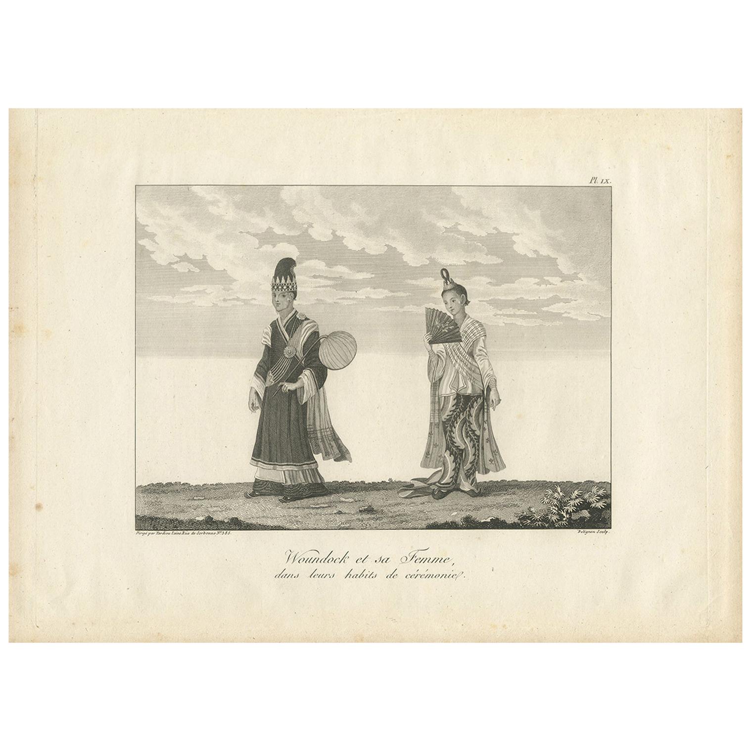
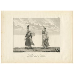
- Antique Print of Burmese Costumes by Symes, '1800'Located in Langweer, NLAntique print titled 'Woundock et sa Femme dans leurs habits de cérémonie'. Print of Burmese costumes. This print originates from 'Relation de l'Ambassade Anglaise, envoyée en 1795 d...Category
Antique Early 19th Century Prints
MaterialsPaper
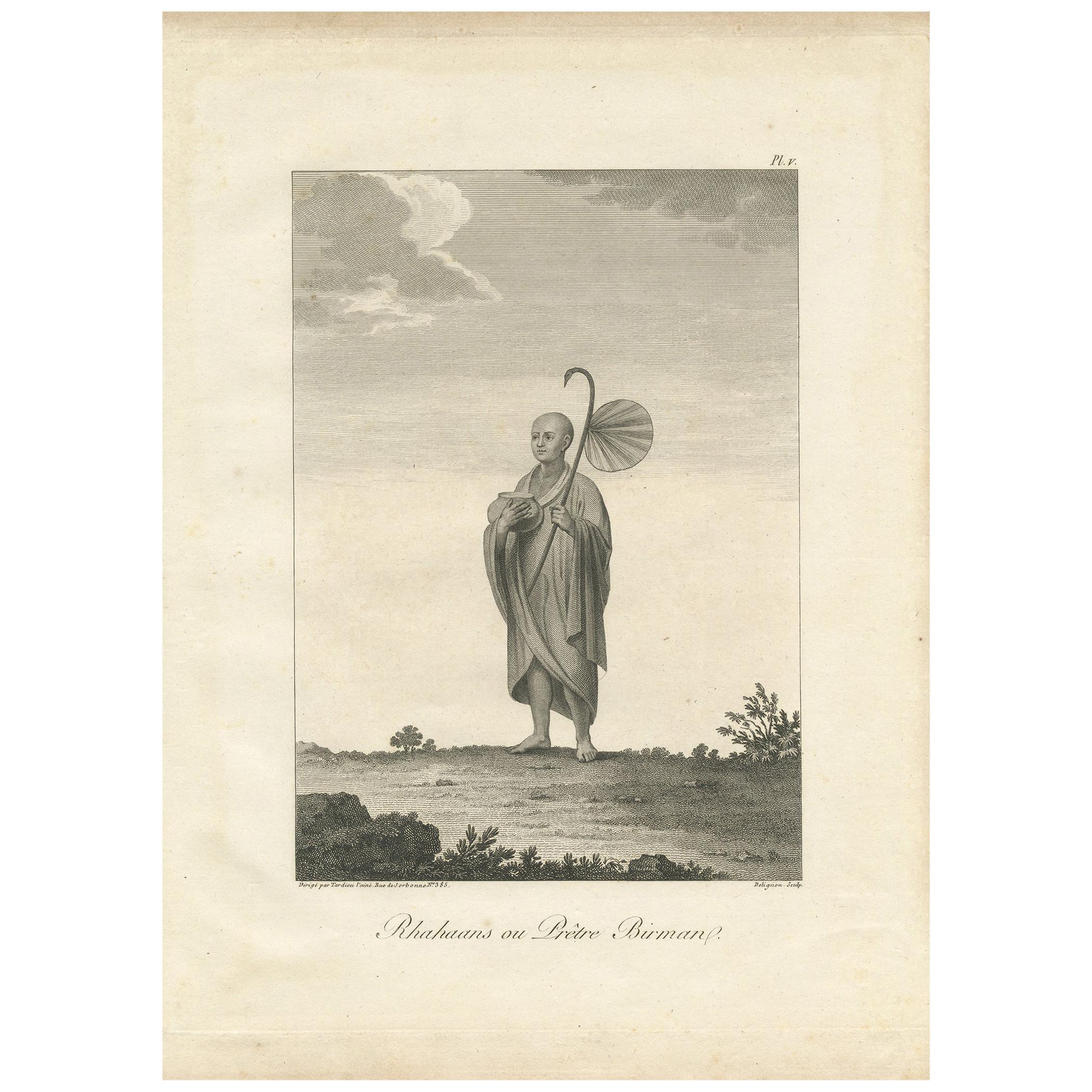
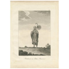
- Antique Print of a Burmese Priest by Symes, 1800Located in Langweer, NLAntique print titled 'Rhahaans ou Prêtre Birman'. Print of a Burmese Priest. This print originates from 'Relation de l'Ambassade Anglaise, envoyée en 1795 dans le Royaume d'Ava, ou l...Category
Antique Early 19th Century Prints
MaterialsPaper
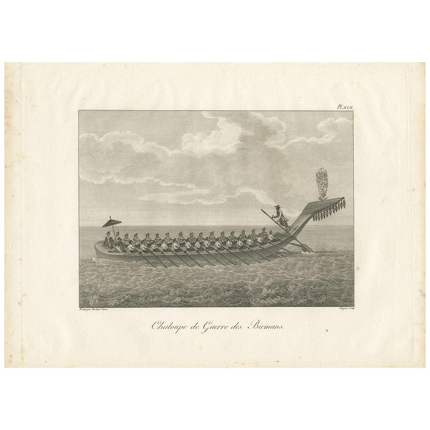
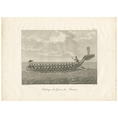
- Antique Print of a Burmese War Boat by Symes '1800'Located in Langweer, NLAntique print titled 'Chaloupe de Guerre Birmans'. Print of a Burmese war boat. This print originates from 'Relation de l'Ambassade Anglaise, envoyée en 1795 dans le Royaume d'Ava, o...Category
Antique Early 19th Century Prints
MaterialsPaper
You May Also Like
- Original Antique Map of The World by Thomas Clerk, 1817Located in St Annes, LancashireGreat map of The Eastern and Western Hemispheres On 2 sheets Copper-plate engraving Drawn and engraved by Thomas Clerk, Edinburgh. Published by Mackenzie And Dent, 1817 ...Category
Antique 1810s English Maps
MaterialsPaper
- Original Antique Map of The Netherlands, Engraved by Barlow, Dated 1807Located in St Annes, LancashireGreat map of Netherlands Copper-plate engraving by Barlow Published by Brightly & Kinnersly, Bungay, Suffolk. Dated 1807 Unframed.Category
Antique Early 1800s English Maps
MaterialsPaper
- Original Antique Map of Russia By Arrowsmith. 1820Located in St Annes, LancashireGreat map of Russia Drawn under the direction of Arrowsmith Copper-plate engraving Published by Longman, Hurst, Rees, Orme and Brown, 1820 Unframed.Category
Antique 1820s English Maps
MaterialsPaper
- Antique Map of Italy by Andriveau-Goujon, 1843By Andriveau-GoujonLocated in New York, NYAntique Map of Italy by Andriveau-Goujon, 1843. Map of Italy in two parts by Andriveau-Goujon for the Library of Prince Carini at Palazzo Carini i...Category
Antique 1840s French Maps
MaterialsLinen, Paper
- Map of the Republic of GenoaLocated in New York, NYFramed antique hand-coloured map of the Republic of Genoa including the duchies of Mantua, Modena, and Parma. Europe, late 18th century. Dimension: 25...Category
Antique Late 18th Century European Maps
- Antique Map of Principality of MonacoBy Antonio Vallardi EditoreLocated in Alessandria, PiemonteST/619 - "Old Geographical Atlas of Italy - Topographic map of ex-Principality of Monaco" - ediz Vallardi - Milano - A somewhat special edition ---Category
Antique Late 19th Century Italian Other Prints
MaterialsPaper


Recently Viewed
View AllMore Ways To Browse
Burma Antique Map
Map Of Provence
World Map Rare
Map Plate
Island Maps
Antique Map Of France
Antique Maps Of France
Antique Historical Maps
16th Century World Map
Antique Old Maps
Old Antique Maps
Germany Map
Buy Antique Paper
Folding Maps
Map Of Germany
Antique Ocean
Antique Copper Collectibles
Modern World Antique Map