Items Similar to Antique Map of the City of Haarlem by Tirion, 1742


Want more images or videos?
Request additional images or videos from the seller
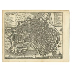
Antique Map of the City of Haarlem by Tirion, 1742
About the Item
Antique map titled 'Grondtekening van Haarlem (..)'. Original antique map of the city of Haarlem, the Netherlands. Published by I. Tirion, 1742.
Artists and Engravers: Isaak Tirion (1705 in Utrecht – 1765 in Amsterdam) was an 18th-century publisher from the Northern Netherlands.
Condition: Fair/good, original folding lines. General age-related toning, minor wear and soiling. Frame included, with some wear and a few small defects. Please study images carefully.
Date: 1742
Overall size: 52.8 x 40 cm.
Image size: 29.5 x 17 cm.
We sell original antique maps to collectors, historians, educators and interior decorators all over the world. Our collection includes a wide range of authentic antique maps from the 16th to the 20th centuries. Buying and collecting antique maps is a tradition that goes back hundreds of years. Antique maps have proved a richly rewarding investment over the past decade, thanks to a growing appreciation of their unique historical appeal. Today the decorative qualities of antique maps are widely recognized by interior designers who appreciate their beauty and design flexibility. Depending on the individual map, presentation, and context, a rare or antique map can be modern, traditional, abstract, figurative, serious or whimsical.
- Creator:Isaak Tirion (Artist)
- Dimensions:Height: 15.75 in (40 cm)Width: 20.79 in (52.8 cm)Depth: 0 in (0.01 mm)
- Materials and Techniques:
- Period:
- Date of Manufacture:1742
- Condition:
- Seller Location:Langweer, NL
- Reference Number:
About the Seller
5.0
Platinum Seller
These expertly vetted sellers are 1stDibs' most experienced sellers and are rated highest by our customers.
Established in 2009
1stDibs seller since 2017
1,950 sales on 1stDibs
Typical response time: <1 hour
- ShippingRetrieving quote...Ships From: Langweer, Netherlands
- Return PolicyA return for this item may be initiated within 14 days of delivery.
More From This SellerView All
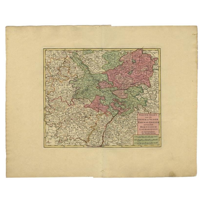
- Antique Map of the Rhineland and Lotharingen by Tirion, c.1740By Isaak TirionLocated in Langweer, NLAntique map titled 'Nieuwe Kaart van de Opper en Neder Rhynse Kreits nevens het Hertogdom Lotharingen.' Attractive detailed map showing the Rheinland (Rhineland) and Lotharingen, Ger...Category
Antique 18th Century Maps
MaterialsPaper
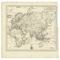
- Antique Map of the Eastern Part of the World by Tirion, 1755By Isaak TirionLocated in Langweer, NLAntique map titled 'Nieuwe Kaart van het Oostelykste Deel der Weereld, dienende tot Aanwyzing van de Scheepstogten der Nederlanderen naar Oostindië'. Australia (Nieuw Holland) shown ...Category
Antique Mid-18th Century Dutch Maps
MaterialsPaper
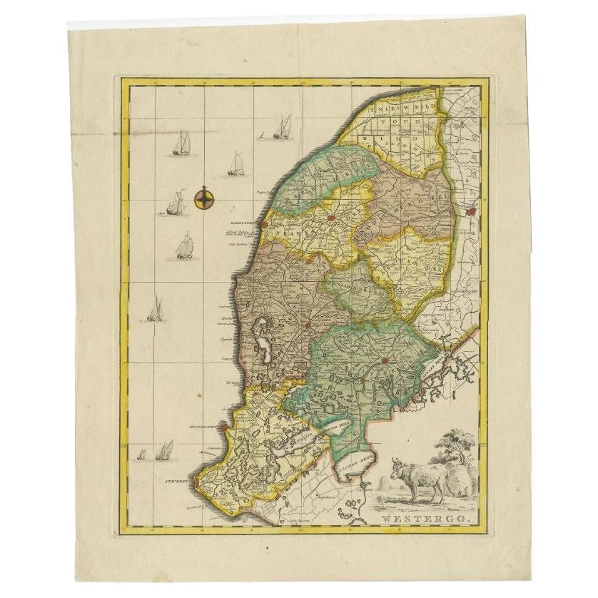
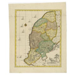
- Antique Map of Westergo, Friesland in the the Netherlands, by Tirion, 1744By Isaak TirionLocated in Langweer, NLAntique map titled 'Westergo'. Original antique map of Westergo, part of the province of Friesland, the Netherlands. Published 1744. Artists and Engravers: Isaak Tirion (1705 in U...Category
Antique 18th Century Maps
MaterialsPaper
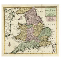
- Antique Map of the South Part of Great Britain by Tirion, c.1750By Isaak TirionLocated in Langweer, NLAntique map titled 'Nieuwe Kaart van 'T Zuider Gedeelte van Groot Britannie behelzende Het Koningryk Engeland (..).' Attractive map showing the south part of Great Britain; the K...Category
Antique 18th Century Maps
MaterialsPaper
- Antique Map of the City of Paris by Tirion '1763'Located in Langweer, NLAntique map titled 'Nieuwe Kaart der platte Grond van de Stad Parys (..)'. Beautiful city plan of Paris, France. This map originates from 'Nieuwe en Beknopte Hand-Atlas, bestaande in...Category
Antique Mid-18th Century Maps
MaterialsPaper
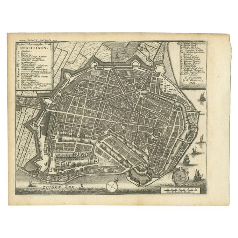
- Antique Map of the City of Enkhuizen by Tirion, 1743Located in Langweer, NLAntique map titled ?Grondtekening der Stad Enkhuisen?. Beautiful map of the City of Enkhuizen. With Dutch legend. Decorated with compass rose, several ships and the city-arms. Artist...Category
Antique 18th Century Maps
MaterialsPaper

You May Also Like
- England, Scotland & Ireland: A Hand Colored Map of Great Britain by TirionBy Isaak TirionLocated in Alamo, CAThis is a hand-colored double page copperplate map of Great Britain entitled "Nieuwe Kaart van de Eilanden van Groot Brittannien Behelzende de Kon...Category
Antique Mid-18th Century Dutch Maps
MaterialsPaper
- 1840 Map of the City of Washington Published by William M. MorrisonLocated in Colorado Springs, COThis map, printed in 1840, is a detailed representation of Washington, D.C. in the mid-19th century. The map shows block numbers, wards, and government buildings as well as details o...Category
Antique 1840s American Federal Maps
MaterialsPaper
- Original Antique Map / City Plan of Brussels by Tallis, circa 1850Located in St Annes, LancashireGreat map of Brussels. Steel engraving. Published by London Printing & Publishing Co. (Formerly Tallis), C.1850 Free shipping.Category
Antique 1850s English Maps
MaterialsPaper
- 1861 Topographical Map of the District of Columbia, by Boschke, Antique MapLocated in Colorado Springs, COPresented is an original map of Albert Boschke's extremely sought-after "Topographical Map of the District of Columbia Surveyed in the Years 1856 ...Category
Antique 1860s American Historical Memorabilia
MaterialsPaper
- Italian Parchment Map of the City of Pisa Dated, 1640By Matthäus Merian the ElderLocated in Roma, ITAn antique map of the Tuscan city of Pisa engraved for The 'Itinerarium Italiæ Nov-antiquæ' by Matthäus Merian the Elder and printed in 1640....Category
Antique 1640s Italian Maps
MaterialsPaper
- Original Antique Map of The World by Thomas Clerk, 1817Located in St Annes, LancashireGreat map of The Eastern and Western Hemispheres On 2 sheets Copper-plate engraving Drawn and engraved by Thomas Clerk, Edinburgh. Published by Mackenzie And Dent, 1817 ...Category
Antique 1810s English Maps
MaterialsPaper


Recently Viewed
View AllMore Ways To Browse
City Used Office Furniture
Tire Antique
Antique Tires
Tirion Map
Framed World Map
Tree Bag
16th Century Scotland
Great Britain Maps
Used Furniture Depot
World Map British
Copper Map Plate
Swiss Antiques And Collectables
Large Antique World Map
Antique World Map Large
Large Antique World Maps
Antique County Maps
Antique Russian Wood Furniture
Antique Russian Wood