Items Similar to Antique Map of Denmark by Moll 'circa 1730'


Want more images or videos?
Request additional images or videos from the seller
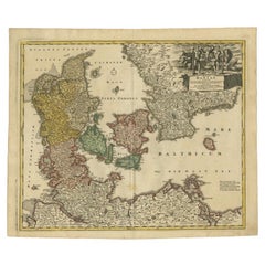
Antique Map of Denmark by Moll 'circa 1730'
About the Item
Antique map titled 'Denmark, agreeable to Modern History'. Uncommon map of Denmark by Herman Moll, published, circa 1730.
- Creator:Herman Moll (Artist)
- Dimensions:Height: 9.85 in (25 cm)Width: 13.39 in (34 cm)Depth: 0.02 in (0.5 mm)
- Materials and Techniques:
- Period:
- Date of Manufacture:circa 1730
- Condition:Great condition, original folding lines. Blank verso, please study image carefully.
- Seller Location:Langweer, NL
- Reference Number:

Herman Moll
Herman Moll (1654-1732) was a prominent mapmaker in London in the early eighteenth century, having moved from Germany in the late 17th century. He initially worked for English printers, but soon opened his own establishment around 1690. He was a friend of the scientist Robert Hooke, the archaeologist William Stuckley, the authors Jonathan Swift and Daniel Defoe, and the pirates William Dampier, Woodes Rogers and William Hacke. He published many atlases, as well as individual maps. He also produced book illustrations, including maps, for books by the pirate William Dampier and Jonathan Swift’s Gulliver’s Travels. Moll died in 1732.
About the Seller
5.0
Platinum Seller
These expertly vetted sellers are 1stDibs' most experienced sellers and are rated highest by our customers.
Established in 2009
1stDibs seller since 2017
1,956 sales on 1stDibs
Typical response time: <1 hour
- ShippingRetrieving quote...Ships From: Langweer, Netherlands
- Return PolicyA return for this item may be initiated within 14 days of delivery.
More From This SellerView All
- Antique Map of Denmark by Covens & Mortier, 1730By Covens & MortierLocated in Langweer, NLAntique Map of Denmark from: 'Atlas Nouveau ... Par Guillaume de l'Isle' Amsterdam, Covens & Mortier, 1730.Category
Antique Mid-18th Century Maps
MaterialsPaper
- Antique Map of Sweden by Homann, 'circa 1730'Located in Langweer, NLAntique map titled 'Nova Tabula Scaniae (..)'. Attractive map showing the historical provinces of Sweden: Schonen with Malmö, Blekinge with Karlskrona and the south part of Halland. ...Category
Antique Mid-18th Century Maps
MaterialsPaper
- Antique Map of Northern Germany by M. Seutter, circa 1730By Matthew SeutterLocated in Langweer, NLAntique map titled 'Saxoniae Inferioris Circulus'. Old map of the northern part of Germany by M. Seutter. Covering the area of Lower Saxony, Mecklenburg-Vorpommern and Schleswig-Hols...Category
Antique Mid-18th Century Maps
MaterialsPaper
- Antique Map of Denmark with the Danish Royal Crest, c.1730By Homann HeirsLocated in Langweer, NLAntique map titled 'Regni Daniae in quo sunt Ducatus Holsatia and Slesuicum Insulae Danicae Jutia, Scania Blekingia (..).' Map of Denmark and islands, part of Sweden and Germany, dra...Category
Antique 18th Century Maps
MaterialsPaper
- Antique Map of France by Mortier 'c.1730'Located in Langweer, NLAntique map titled 'Galliae Antiquae Tabula'. Original antique map of France in ancient times. Published by P. Mortier, circa 1730.Category
Antique Mid-18th Century Maps
MaterialsPaper
- Antique Map of Denmark by Valk 'circa 1690'Located in Langweer, NLThe map titled "Regnum Daniae, divisum in Dioeceses Arhusiam, Albergum, Viborgum, et Ripam (..)" is a meticulously detailed representation of the Kingdom of Denmark during a historic...Category
Antique Late 17th Century Maps
MaterialsPaper


You May Also Like
- Original Antique Map of Belgium by Tallis, Circa 1850Located in St Annes, LancashireGreat map of Belgium Steel engraving Many lovely vignettes Published by London Printing & Publishing Co. ( Formerly Tallis ), C.1850 Origin...Category
Antique 1850s English Maps
MaterialsPaper
- Original Antique Map / City Plan of Brussels by Tallis, circa 1850Located in St Annes, LancashireGreat map of Brussels. Steel engraving. Published by London Printing & Publishing Co. (Formerly Tallis), C.1850 Free shipping.Category
Antique 1850s English Maps
MaterialsPaper
- Original Antique Map of South East Asia by Becker, circa 1840Located in St Annes, LancashireGreat map of South East Asia Steel engraving with original color outline Engraved by Becker Published by Virtue, circa 1840. Unframed.Category
Antique 1840s English Other Maps
MaterialsPaper
- Original Antique Map of Spain and Portugal, circa 1790Located in St Annes, LancashireSuper map of Spain and Portugal Copper plate engraving by A. Bell Published, circa 1790. Unframed.Category
Antique 1790s English Other Maps
MaterialsPaper
- Antique Map of Italy by Andriveau-Goujon, 1843By Andriveau-GoujonLocated in New York, NYAntique Map of Italy by Andriveau-Goujon, 1843. Map of Italy in two parts by Andriveau-Goujon for the Library of Prince Carini at Palazzo Carini i...Category
Antique 1840s French Maps
MaterialsLinen, Paper
- Original Antique Map of Russia By Arrowsmith. 1820Located in St Annes, LancashireGreat map of Russia Drawn under the direction of Arrowsmith Copper-plate engraving Published by Longman, Hurst, Rees, Orme and Brown, 1820 Unframed.Category
Antique 1820s English Maps
MaterialsPaper


Recently Viewed
View AllMore Ways To Browse
Modern History
Antique Maps 18th Century
Antique Danish Modern Furniture
Danish Modern Antique Furniture
Danish Antique And Modern
Denmark Maps
Denmark Map
Antique Map Denmark
Original Antique World Map
Map Of United States
Antique German Collectible
Authentic Antique Maps
The United States Map
Map France
Map Of The United States
Antiques From Scotland
France Antique Map
Antique Map France