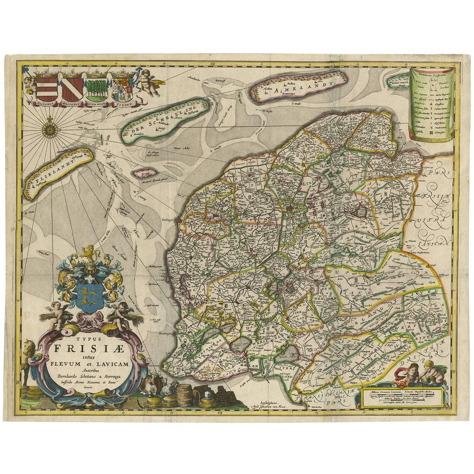
Items Similar to Antique Map of Friesland with Four Coats of Arms, 1664

Want more images or videos?
Request additional images or videos from the seller
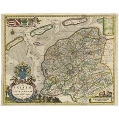
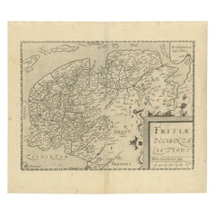
Antique Map of Friesland with Four Coats of Arms, 1664
About the Item
Antique map titled 'Typus Frisiae inter Fevum et Lavicam'. Original antique map of the province of Friesland, the Netherlands. Also shows the Wadden islands Vlieland, Terschelling and Ameland and part of Schiermonnikoog. With a decorative cartouche with two putti, livestock and cheese and milk barrels. Four coats of arms in the top left corner. Third state, originating from: 'Beschrijvinge van de Heerlyckheydt van Frieslandt'. Published 1664. Artists and Engravers: Cartographers: Bernardus Schotanus a Sterringa, Sjoerd Aetesz Haackma and Sytse Gravius.
Artist: Cartographers: Bernardus Schotanus a Sterringa, Sjoerd Aetesz Haackma and Sytse Gravius.
Condition: Very good, given age. Original middle fold, as issued but flattened out in the image area. Some small stains and creases in the margins. Two tiny tears in the top margin. Blank verso. General age-related toning and/or occasional minor defects from handling. Please study scan carefully.
Date: 1664
Overall size: 59.3 x 50.4 cm.
Image size: 52.6 x 42.4 cm.
We sell original antique maps to collectors, historians, educators and interior decorators all over the world. Our collection includes a wide range of authentic antique maps from the 16th to the 20th centuries. Buying and collecting antique maps is a tradition that goes back hundreds of years. Antique maps have proved a richly rewarding investment over the past decade, thanks to a growing appreciation of their unique historical appeal. Today the decorative qualities of antique maps are widely recognized by interior designers who appreciate their beauty and design flexibility. Depending on the individual map, presentation, and context, a rare or antique map can be modern, traditional, abstract, figurative, serious or whimsical. We offer a wide range of authentic antique maps for any budget.
- Dimensions:Height: 19.85 in (50.4 cm)Width: 23.35 in (59.3 cm)Depth: 0 in (0.01 mm)
- Materials and Techniques:
- Period:
- Date of Manufacture:1664
- Condition:
- Seller Location:Langweer, NL
- Reference Number:
About the Seller
5.0
Platinum Seller
These expertly vetted sellers are 1stDibs' most experienced sellers and are rated highest by our customers.
Established in 2009
1stDibs seller since 2017
1,950 sales on 1stDibs
Typical response time: <1 hour
- ShippingRetrieving quote...Ships From: Langweer, Netherlands
- Return PolicyA return for this item may be initiated within 14 days of delivery.
More From This SellerView All
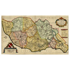
- Antique Map of Friesland 'The Netherlands' by B. Schotanus, 1664By B. SchotanusLocated in Langweer, NLHand-colored map of the Dutch province Friesland. Also shows the Wadden islands Vlieland, Terschelling and Ameland and a part of Schiermonnikoog. With a decorative cartouche with two...Category
Antique Late 17th Century Maps
MaterialsPaper
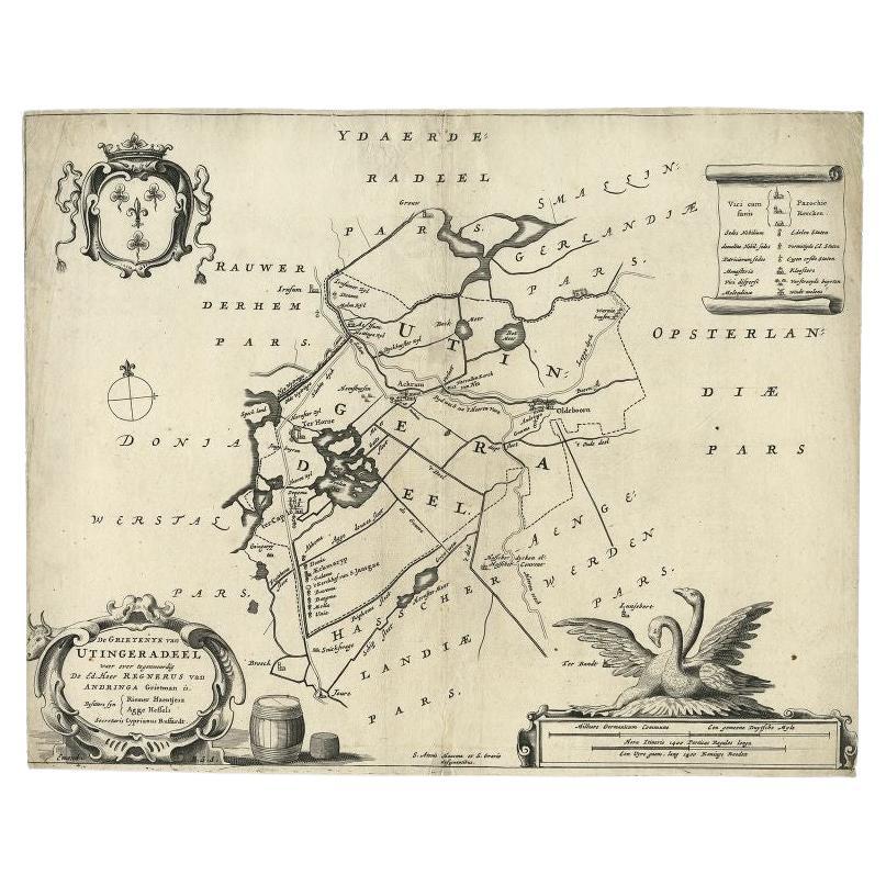
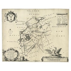
- Antique Map of the Region of Utingeradeel in Friesland, The Netherlands, 1664By B. SchotanusLocated in Langweer, NLAntique map titled 'De Grietenye van Utingeradeel (..)'. Map of the Grietenij of Utingeradeel, Friesland, The Netherlands. Multiple cartouches, key and coat of arms. "Beschrijvinge e...Category
Antique 17th Century Maps
MaterialsPaper
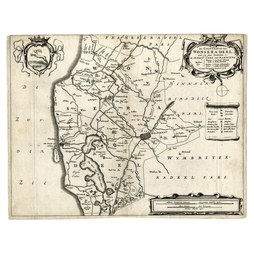
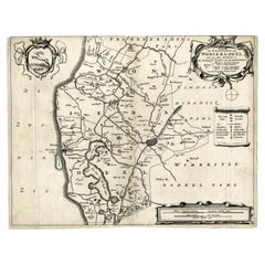
- Antique Map of the Region of Wonseradeel, Friesland in the Netherlands, 1664By B. SchotanusLocated in Langweer, NLAntique map titled 'De Grietenije van Wonsera-deel (..).' Map of the Grietenij of Wonseradeel, Friesland, The Netherlands. Multiple cartouches, key and coat of arms. "Beschrijvinge e...Category
Antique 17th Century Maps
MaterialsPaper
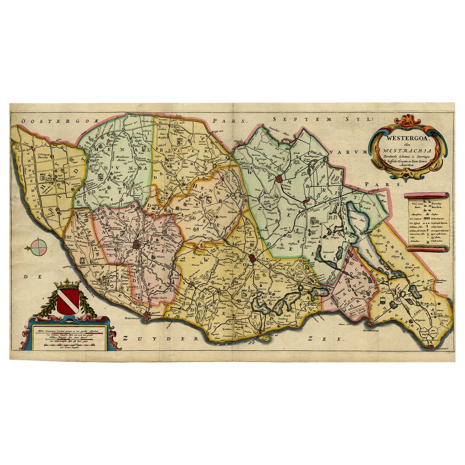
- Map of the Shire of Westergo in the Province of Friesland, the Netherlands, 1664Located in Langweer, NLAntique map titled 'Westergoa Olim Westrachia.' Map of the shire of Westergo in the province of Friesland in the Netherlands, including Stavoren, Bolswar...Category
Antique 1660s Maps
MaterialsPaper
- Original Antique Map of Friesland by Guicciardini, 1612Located in Langweer, NLAntique map titled 'Frisiae Occidentalis Typus'. Original antique map of the province of Friesland, the Netherlands. This map originates from 'Beschryvinghe van alle de Neder-Landen'...Category
Antique 17th Century Maps
MaterialsPaper
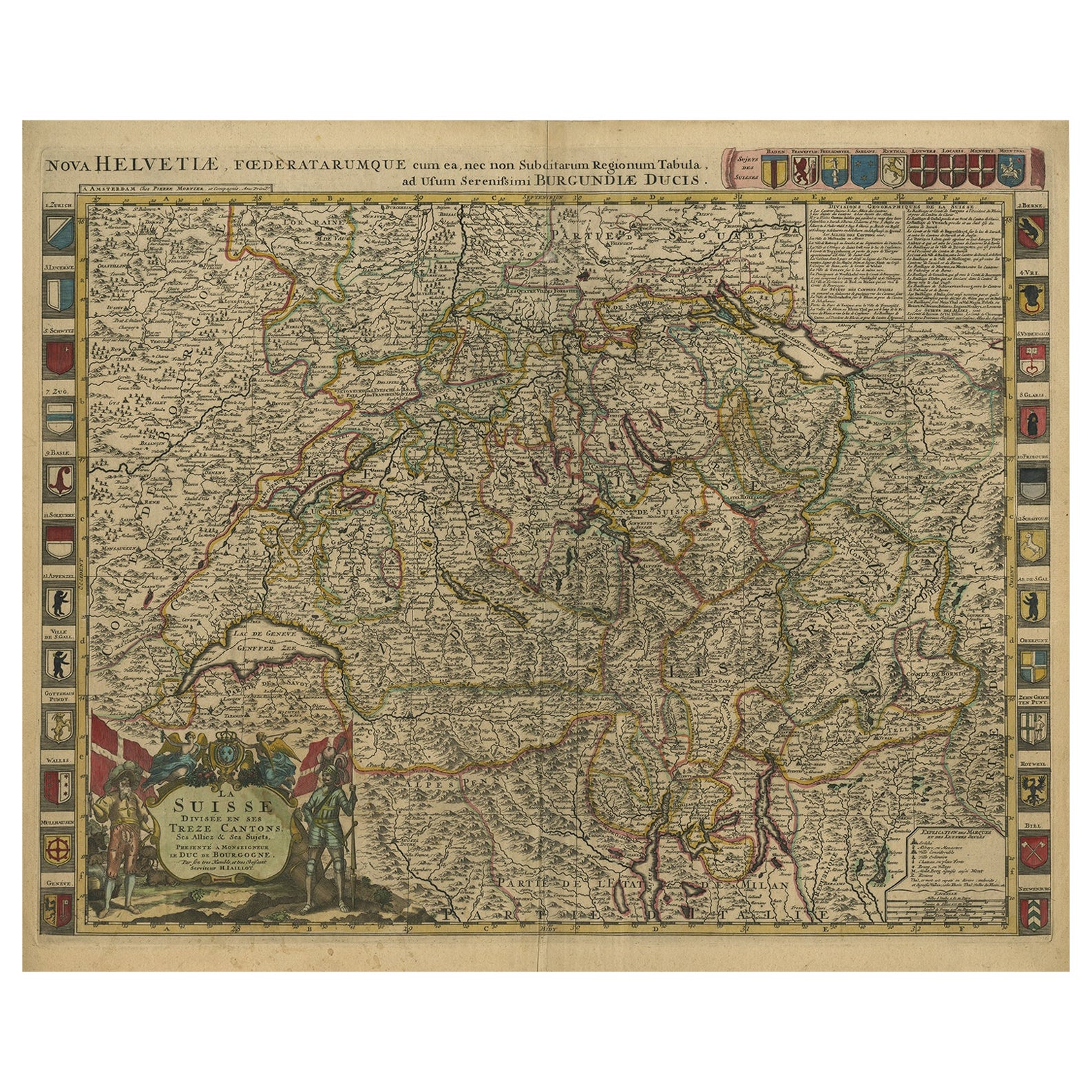
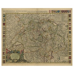
- Beautiful Antique Handcolored Map of Switzerland with 33 Coats of Arms, ca.1705Located in Langweer, NLAntique map Switerzland titled 'La Suisse Divisee en ses Treze Cantons, ses Alliez & ses Sujets (..)'. Beautiful map of Switzerland with 33 coats of arms. The map is dedicated to t...Category
Antique Early 1700s Maps
MaterialsPaper
You May Also Like
- Antique Map of Principality of MonacoBy Antonio Vallardi EditoreLocated in Alessandria, PiemonteST/619 - "Old Geographical Atlas of Italy - Topographic map of ex-Principality of Monaco" - ediz Vallardi - Milano - A somewhat special edition ---Category
Antique Late 19th Century Italian Other Prints
MaterialsPaper
- Original Antique Map of Italy. C.1780Located in St Annes, LancashireGreat map of Italy Copper-plate engraving Published C.1780 Unframed.Category
Antique Early 1800s English Georgian Maps
MaterialsPaper

- Original Antique Map of Asia. C.1780Located in St Annes, LancashireGreat map of Asia Copper-plate engraving Published C.1780 Two small worm holes to right side of map Unframed.Category
Antique Early 1800s English Georgian Maps
MaterialsPaper

- Original Antique Map of India. C.1780Located in St Annes, LancashireGreat map of India Copper-plate engraving Published C.1780 Three small worm holes to right side of map and one bottom left corner Unframed.Category
Antique Early 1800s English Georgian Maps
MaterialsPaper

- Original Antique Map of Italy. Arrowsmith. 1820Located in St Annes, LancashireGreat map of Italy Drawn under the direction of Arrowsmith Copper-plate engraving Published by Longman, Hurst, Rees, Orme and Brown, 1820 Unframed.Category
Antique 1820s English Maps
MaterialsPaper
- Original Antique Map of Ireland- Kerry. C.1840Located in St Annes, LancashireGreat map of Kerry Steel engraving Drawn under the direction of A.Adlard Published by How and Parsons, C.1840 Unframed.Category
Antique 1840s English Maps
MaterialsPaper


Recently Viewed
View AllMore Ways To Browse
Four Coat
Antique Coats Of Arms
Coat Middle
Antique State Maps
Four Putti
Antique Milk Can
Antique Milk Cans
Milk Cans Antique
Antique Milking Can
Milk Can Antique
Map Of Antique Province
Antique Province Map Of Antique
Vans Coat Of Arms
Collection Of Small Milk
Putti On Paper
Netherlands 16th Century
Antique Furniture In Texas
Antique Maps Of England