Items Similar to Antique Map of the Islands of Macian and Bacian by De Bry, 1619


Want more images or videos?
Request additional images or videos from the seller
1 of 5
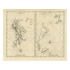
Antique Map of the Islands of Macian and Bacian by De Bry, 1619
About the Item
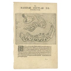
Antique map titled 'Delineatio Insularum Macian et Bacian'. Depicts the islands Macian and Bacian. Originates from 'Americae pars Undecima (..) by J.T. de Bry, 1619.
Artists and Engravers: Johann Theodor de Bry (1561 - 1623) was born in Liege in 1561, the eldest son of the engraver and publisher Theodor de Bry. It was from his father that Johann learned his Craft, producing both engravings and etchings.
Condition: Very good, minor wear. Blank verso, please study image carefully.
Date: 1619
Overall size: 23.5 x 34 cm.
Image size: 19.3 x 26 cm.
We sell original antique maps to collectors, historians, educators and interior decorators all over the world. Our collection includes a wide range of authentic antique maps from the 16th to the 20th centuries. Buying and collecting antique maps is a tradition that goes back hundreds of years. Antique maps have proved a richly rewarding investment over the past decade, thanks to a growing appreciation of their unique historical appeal. Today the decorative qualities of antique maps are widely recognized by interior designers who appreciate their beauty and design flexibility. Depending on the individual map, presentation, and context, a rare or antique map can be modern, traditional, abstract, figurative, serious or whimsical. We offer a wide range of authentic antique maps for any budget.
- Dimensions:Height: 13.39 in (34 cm)Width: 9.26 in (23.5 cm)Depth: 0 in (0.01 mm)
- Materials and Techniques:
- Period:
- Date of Manufacture:1619
- Condition:
- Seller Location:Langweer, NL
- Reference Number:
About the Seller
5.0
Platinum Seller
These expertly vetted sellers are 1stDibs' most experienced sellers and are rated highest by our customers.
Established in 2009
1stDibs seller since 2017
1,967 sales on 1stDibs
Typical response time: <1 hour
- ShippingRetrieving quote...Ships From: Langweer, Netherlands
- Return PolicyA return for this item may be initiated within 14 days of delivery.
More From This SellerView All
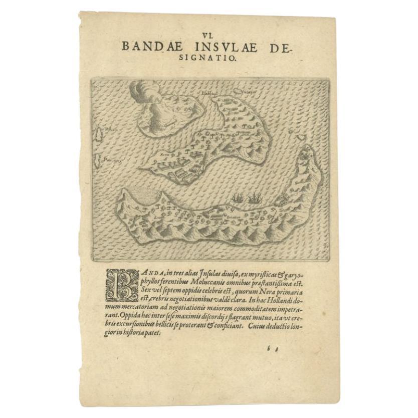
- Antique Map of the Banda Islands by De Bry, c.1600Located in Langweer, NLAntique map Indonesia titled 'Bandae Insulae designatio'. Antique map depicting the Banda Islands, Indonesia. With Latin text, blank verso. Orig...Category
Antique 17th Century Maps
MaterialsPaper
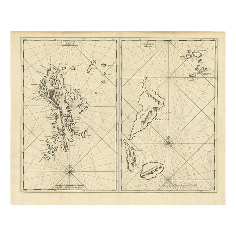
- Antique Map of Sangir Island and the Talaud Islands by Valentijn, 1726Located in Langweer, NLAntique map titled 'Het Eyland Sangir & De Talautse Eylanden'. Two maps on one sheet. To the left, a map of Sangir Island, Indonesia. To the right, a map of the Talaud Islands, Indon...Category
Antique 18th Century Maps
MaterialsPaper
- Antique Map of the Islands of the Atlantic by J. TallisLocated in Langweer, NLA highly decorative and detailed mid-19th century map of the Islands of the Atlantic -- including the Azores, Madeira, Bermuda, the Canary Islands and the Cape Verde Islands -- which...Category
Antique Mid-19th Century Maps
MaterialsPaper
- Antique Map of the Islands Within the Queen Charlotte's IslandsLocated in Langweer, NLAntique map titled 'Cote Septentrional de la plus grande des Isles de la Reine Charlotte (..)'. Map and coastal view of the islands within the Queen Charlotte's Islands (Santa Cruz I...Category
Antique Late 18th Century Maps
MaterialsPaper
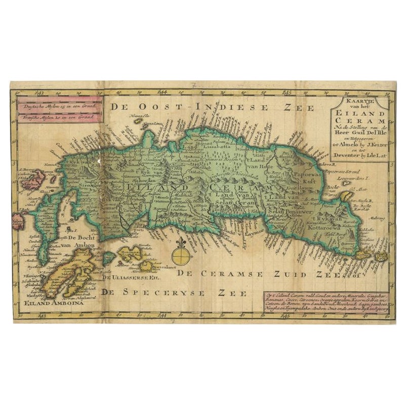
- Antique Map of Seram Island by Keizer & De Lat, c.1747Located in Langweer, NLAntique map titled 'Kaart van het eiland Ceram'. Rare and uncommon map of Seram Island, Indonesia. One of the earliest separately printed maps of the island. Artists and Engravers: P...Category
Antique 18th Century Maps
MaterialsPaper
- Antique Map of the Atlantic Islands, 1817Located in Langweer, NLAntique map titled 'Atlantic Islands'. Large map of the Atlantic Islands include the Cape Verde islands, Canary islands, Azore islands and Madeira islands. Also included a view of th...Category
Antique Early 19th Century Maps
MaterialsPaper


You May Also Like
- 1854 Map of Massachusetts, Connecticut and Rhode Island, Antique Wall MapLocated in Colorado Springs, COThis striking wall map was published in 1854 by Ensign, Bridgman & Fanning and has both full original hand-coloring and original hardware. This impression is both informative and highly decorative. The states are divided into counties, outlined in red, green, and black, and subdivided into towns. Roads, canals, and railroad lines are prominently depicted, although they are not all labeled. The mapmakers also marked lighthouses, banks, churches, and prominent buildings, with a key at right. The map is an informative and comprehensive overview of the infrastructural development of New England prior to the Civil War. Physical geographies depicted include elevation, conveyed with hachure marks, rivers and lakes. The impression features an inset map of Boston...Category
Antique 19th Century American Maps
MaterialsPaper
- 1861 Topographical Map of the District of Columbia, by Boschke, Antique MapLocated in Colorado Springs, COPresented is an original map of Albert Boschke's extremely sought-after "Topographical Map of the District of Columbia Surveyed in the Years 1856 ...Category
Antique 1860s American Historical Memorabilia
MaterialsPaper
- Large Original Antique Map of Rhode Island, USA, C.1900Located in St Annes, LancashireFabulous map of Rhode Island Original color Engraved and printed by the George F. Cram Company, Indianapolis. Published, C.1900 Unframed Free ...Category
Antique 1890s American Maps
MaterialsPaper
- 1868 Map of the Upper Part of the Island of Manhattan Above 86th StreetBy Wm. Rogers Mfg. Co.Located in San Francisco, CAThis wonderful piece of New York City history is over 150 years old. It depicts 86th street and above. It was lithographed by WC Rogers and company. It was made to show what was the Battle of Harlem during the Revolutionary war...Category
Antique 1860s American American Colonial Maps
MaterialsPaper
- Early 19th Century Hand Colored Map of the United States and Caribbean IslandsLocated in Hamilton, OntarioHand coloured early 19th century map by Giraldon of France titled "Etats Unis et Grandes Antilles" (United States and Greater Antilles).Category
Antique Early 19th Century French Maps
MaterialsPaper
- Hand-Colored 18th Century Homann Map of Denmark and Islands in the Baltic SeaBy Johann Baptist HomannLocated in Alamo, CAAn 18th century copper plate hand-colored map entitled "Insulae Danicae in Mari Balthico Sitae utpote Zeelandia, Fionia, Langelandia, Lalandia, Falstria, Fembria Mona" created by Joh...Category
Antique Early 18th Century German Maps
MaterialsPaper


Recently Viewed
View AllMore Ways To Browse
Antique Stand Up Scale
Antique Railroad Collectables
Antique Railroad Collectibles Collectibles
Antique Railroad Collectibles
Maps Of Georgia
South Africa Antique Map
Antique Georgia Map
Antique Georgia Maps
Map Nautical Chart
Map New Amsterdam
18th Century Antique Mexican
Albanian Antique
East Africa Map
Antique Map Brazil
Antique Map Of Brazil
Antique Maps Persia
Antique Pirate
James Johnston