Items Similar to Antique Map by Janssonius of the Dutch Province of Overijsel, ca.1650


Want more images or videos?
Request additional images or videos from the seller
1 of 6
Antique Map by Janssonius of the Dutch Province of Overijsel, ca.1650
About the Item
Very good, given the age. Center fold as issued with wide margins. Sharp print with beautiful old-fashioned colouring, carbon copy on verso. Paper in the margins somewhat browned.
- Dimensions:Height: 19.3 in (49 cm)Width: 22.84 in (58 cm)Depth: 0 in (0.02 mm)
- Materials and Techniques:Paper,Engraved
- Period:1650-1659
- Date of Manufacture:ca.1650
- Condition:Good, given the age. Center fold as issued with wide margins. Sharp print with beautiful old-fashioned colouring. Latin text on verso. Paper overall equally slightly browned. Please study image carefully.
- Seller Location:Langweer, NL
- Reference Number:1stDibs: LU3054329548172
About the Seller
5.0
Platinum Seller
These expertly vetted sellers are 1stDibs' most experienced sellers and are rated highest by our customers.
Established in 2009
1stDibs seller since 2017
1,946 sales on 1stDibs
Typical response time: <1 hour
- ShippingRetrieving quote...Ships From: Langweer, Netherlands
- Return PolicyA return for this item may be initiated within 14 days of delivery.
More From This SellerView All
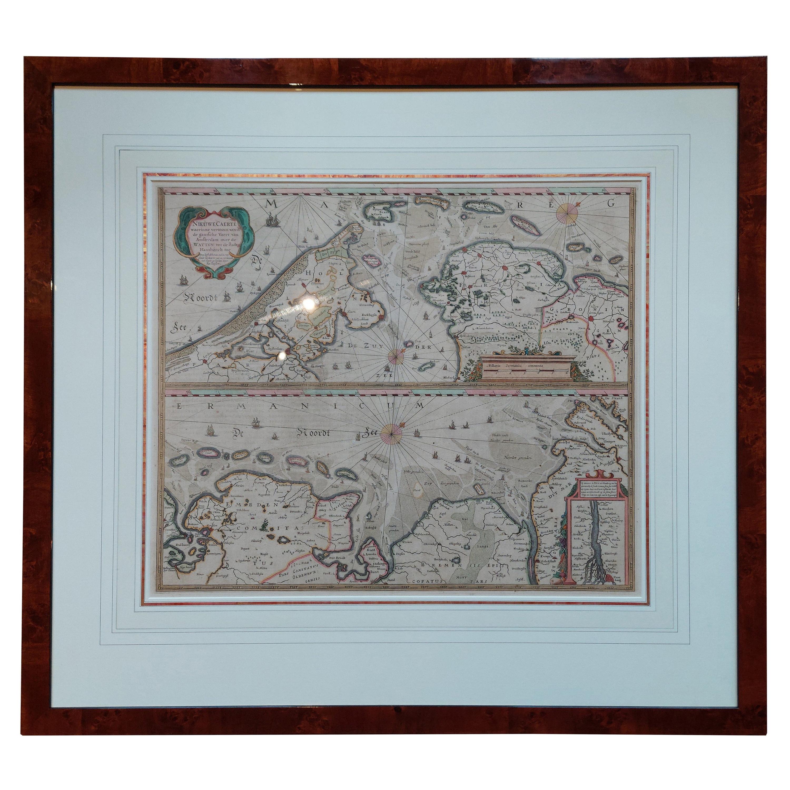
- Antique Map of the Coast of Holland and Germany by Janssonius 'c.1650'Located in Langweer, NLAntique map titled 'Nieuwe Caerte waerinne vertoont wordt de gantsche Vaert van Amsterdam over de Watten tot de stadt Hamborch toe'. Two maps with the Dutch and German North Sea coas...Category
Antique Mid-17th Century Maps
MaterialsPaper
- Antique Map of France by Janssonius, c.1650Located in Langweer, NLAntique map titled 'Gallia Vetus'. Beautiful map of France based on Caesar's De Bello Gallico. In the columns to the left and right important tribes and people are described. Art...Category
Antique 17th Century Maps
MaterialsPaper
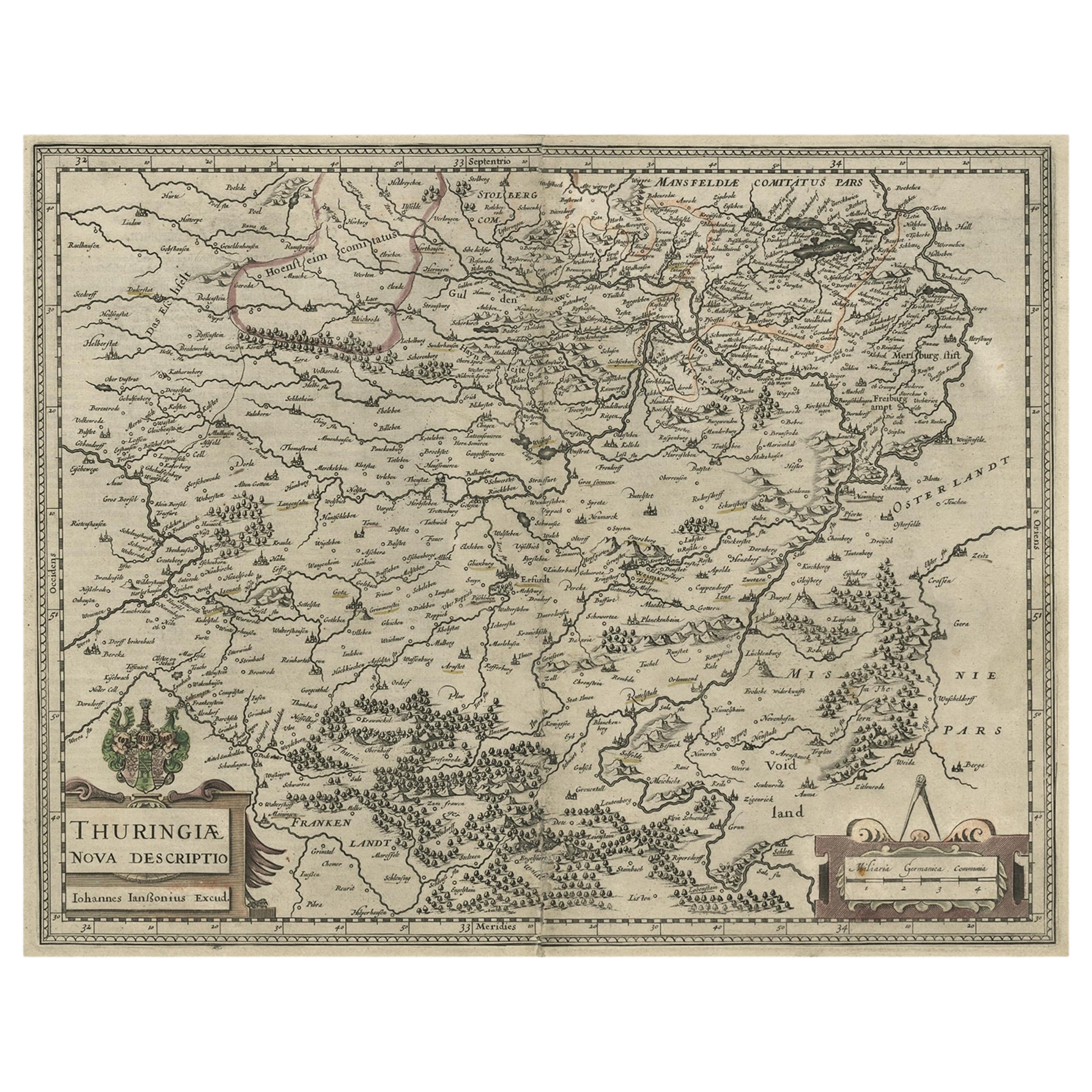
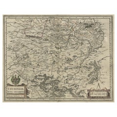
- Detailed Original Antique Map of Thuringia, Germany by J. Janssonius, ca.1650Located in Langweer, NLAntique map titled 'Thuringiae Nova Descriptio.' Detailed map of Thuringia, Germany by J. Janssonius. With one cartouche, coat-of-arms and a mileage scale. With Erfurt in the centre....Category
Antique 1650s Maps
MaterialsPaper
- Antique Map of Java by Janssonius, circa 1650Located in Langweer, NLAntique map titled 'Insulae Iavae cum parte insularum Borneo Sumatrae, et circumjacentium insularum novissima delineatio'. Beautiful map of Java and parts of Bali, Borneo, Sumatra an...Category
Antique Mid-17th Century Maps
MaterialsPaper
- Antique Map of the Vermandois Region by Janssonius, circa 1650By Johannes JanssoniusLocated in Langweer, NLAntique map titled 'Vermandois'. Old map of the Vermandois region, France. Vermandois was a French County that appeared in the Merovingian period. Its na...Category
Antique Mid-17th Century Maps
MaterialsPaper
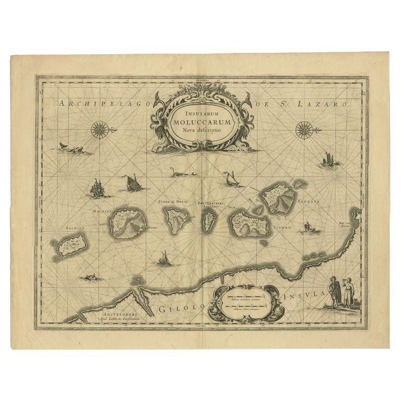
- Antique Map of the Moluccas in Indonesia by Janssonius, C.1650By Johannes JanssoniusLocated in Langweer, NLAntique map titled 'Insularum Moluccarum Nova Descriptio.' Old map of the Moluccas. The famous Spice Islands, the cornerstone of the Dutch trading ...Category
Antique 17th Century Maps
MaterialsPaper


You May Also Like
- Antique 18th Century Map of the Province of Pensilvania 'Pennsylvania State'Located in Philadelphia, PAA fine antique of the colony of Pennsylvania. Noted at the top of the sheet as a 'Map of the province of Pensilvania'. This undated and anonymous map is thought to be from the Gentleman's Magazine, London, circa 1775, although the general appearance could date it to the 1760's. The southern boundary reflects the Mason-Dixon survey (1768), the western boundary is placed just west of Pittsburgh, and the northern boundary is not marked. The map has a number of reference points that likely refer to companion text and appear to be connected to boundaries. The western and southern boundaries are marked Q, R, S, for example. A diagonal line runs from the Susquehanna R to the Lake Erie P. A broken line marked by many letters A, B, N, O, etc., appears in the east. There are no latitude or longitude markings, blank verso. Framed in a shaped contemporary gilt wooden frame and matted under a cream colored matte. Bearing an old Graham Arader Gallery...Category
Antique 18th Century British American Colonial Maps
MaterialsPaper
- 17th Century Hand-Colored Map of a Region in West Germany by JanssoniusBy Johannes JanssoniusLocated in Alamo, CAThis attractive highly detailed 17th century original hand-colored map is entitled "Archiepiscopatus Maghdeburgensis et Anhaltinus Ducatus cum terris adjacentibus". It was published ...Category
Antique Mid-17th Century Dutch Maps
MaterialsPaper
- Prussia, Poland, N. Germany, Etc: A Hand-colored 17th Century Map by JanssoniusBy Johannes JanssoniusLocated in Alamo, CAThis is an attractive hand-colored copperplate engraved 17th century map of Prussia entitled "Prussia Accurate Descripta a Gasparo Henneberg Erlichensi", published in Amsterdam by Joannes Janssonius in 1664. This very detailed map from the golden age of Dutch cartography includes present-day Poland, Latvia, Lithuania, Estonia and portions of Germany. This highly detailed map is embellished by three ornate pink, red, mint green and gold...Category
Antique Mid-17th Century Dutch Maps
MaterialsPaper
- The Holy Land at the Time of Jesus: A 17th Century Dutch Map by VisscherBy Nicolaes Visscher IILocated in Alamo, CAThis detailed Dutch map entitled "Het Beloofe de Landt Canaan door wandelt van onsen Salichmaecker Iesu Christo, nessens syne Apostelen" by Nicolaes Visscher was published in Amsterd...Category
Antique Mid-17th Century Dutch Maps
MaterialsPaper
- Original Antique Map of The World by Thomas Clerk, 1817Located in St Annes, LancashireGreat map of The Eastern and Western Hemispheres On 2 sheets Copper-plate engraving Drawn and engraved by Thomas Clerk, Edinburgh. Published by Mackenzie And Dent, 1817 ...Category
Antique 1810s English Maps
MaterialsPaper
- Original Antique Map of The Netherlands, Engraved by Barlow, Dated 1807Located in St Annes, LancashireGreat map of Netherlands Copper-plate engraving by Barlow Published by Brightly & Kinnersly, Bungay, Suffolk. Dated 1807 Unframed.Category
Antique Early 1800s English Maps
MaterialsPaper


Recently Viewed
View AllMore Ways To Browse
Bubble Glass Book Ends
Map Cleveland
Rand McNally & Co. On Sale
Vintage Butcher Shop Posters
Antique Map Of Iceland
Antique Map Of Maine
Antique Maps Of Maine
Bolivia Antique Map
Maps Balkans
Ottoman Empire Map
Irish Canterbury Furniture
Irish Canterbury
Ottoman Map
Antique Chinese Rob
Gilded Stand 1600
Map 1700s
Babylon Map
Jordan Antique Map