Items Similar to Antique Map of the Mountain Chains of Europe and Asia by Johnston '1850'


Want more images or videos?
Request additional images or videos from the seller
1 of 5
Antique Map of the Mountain Chains of Europe and Asia by Johnston '1850'
About the Item
Antique map titled 'The Mountain chains of the Europe and Asia '. Original antique map of the mountain chains of Europe and Asia. This map originates from 'The Physical Atlas of Natural Phenomena' by A.K. Johnston, published 1850.
- Dimensions:Height: 11.03 in (28 cm)Width: 14.18 in (36 cm)Depth: 0.02 in (0.5 mm)
- Materials and Techniques:
- Period:
- Date of Manufacture:1850
- Condition:General age-related toning. Minor wear, blank verso. Please study image carefully.
- Seller Location:Langweer, NL
- Reference Number:Seller: BG-12790-31stDibs: LU3054323451782
About the Seller
5.0
Platinum Seller
These expertly vetted sellers are 1stDibs' most experienced sellers and are rated highest by our customers.
Established in 2009
1stDibs seller since 2017
2,088 sales on 1stDibs
Typical response time: <1 hour
- ShippingRetrieving quote...Ships From: Langweer, Netherlands
- Return PolicyA return for this item may be initiated within 14 days of delivery.
Authenticity Guarantee
In the unlikely event there’s an issue with an item’s authenticity, contact us within 1 year for a full refund. DetailsMoney-Back Guarantee
If your item is not as described, is damaged in transit, or does not arrive, contact us within 7 days for a full refund. Details24-Hour Cancellation
You have a 24-hour grace period in which to reconsider your purchase, with no questions asked.Vetted Professional Sellers
Our world-class sellers must adhere to strict standards for service and quality, maintaining the integrity of our listings.Price-Match Guarantee
If you find that a seller listed the same item for a lower price elsewhere, we’ll match it.Trusted Global Delivery
Our best-in-class carrier network provides specialized shipping options worldwide, including custom delivery.More From This Seller
View AllAntique Detailed Map of the Mountain Chains of Europe and Asia, c.1850
Located in Langweer, NL
Antique map titled 'The Mountain Chains of Europe & Asia'.
Old map depicting the mountain chains of Europe and Asia. Originates from 'The Physical Atlas of Natural Phenomena'.
Ar...
Category
Antique 19th Century Maps
Materials
Paper

Antique Map of the River Systems of Europe and Asia by Johnston '1850'
Located in Langweer, NL
Antique map titled 'The River Systems of Europe and Asia showing the boundaries and comparative extent of the river basins'. Original antique map of the river systems of Europe and A...
Category
Antique Mid-19th Century Maps
Materials
Paper

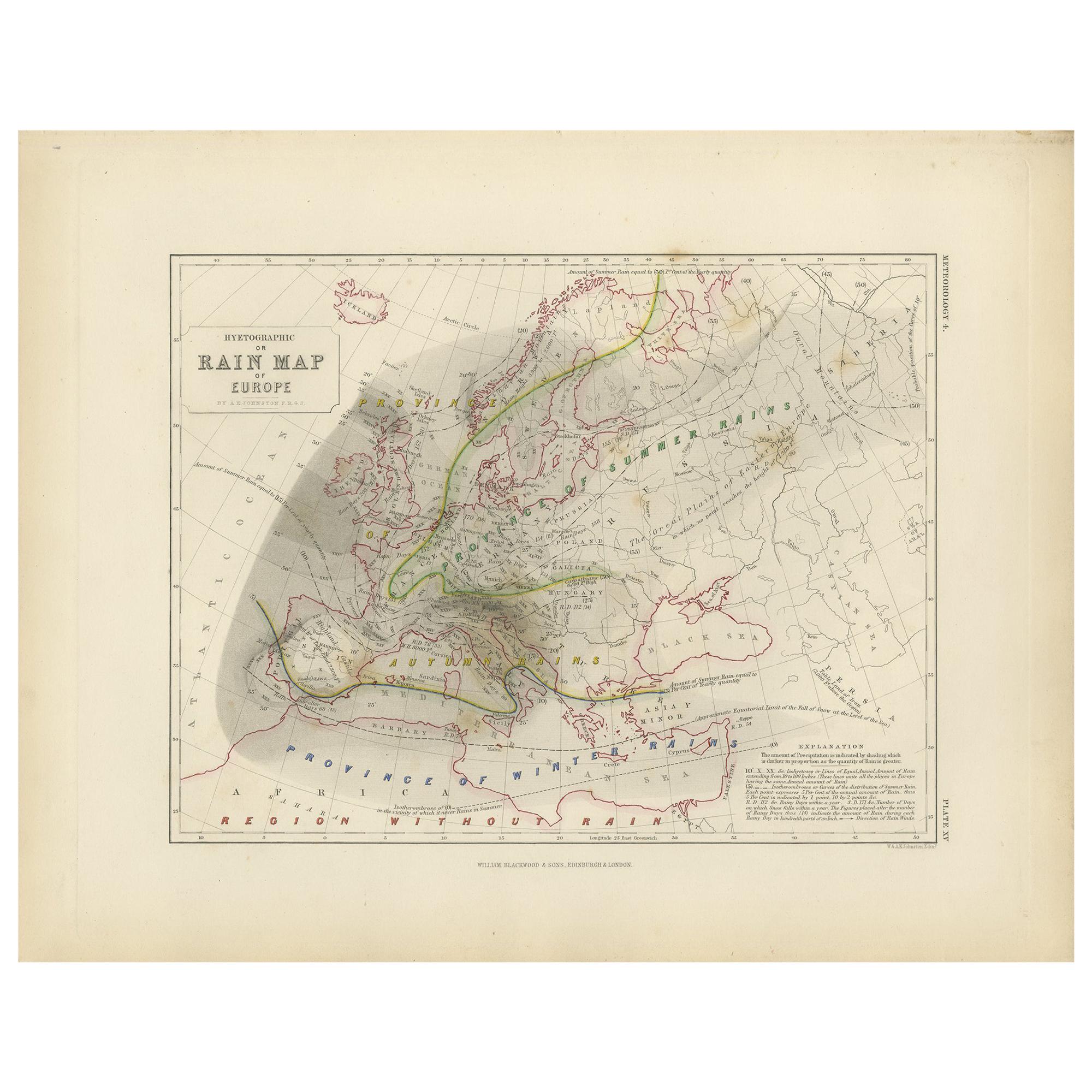
Antique Rain Map of Europe by Johnston '1850'
Located in Langweer, NL
Antique map titled 'Hyetographic or Rain Map of Europe'. Original antique rain map of Europe. This map originates from 'The Physical Atlas of Natural Phenomena' by A.K. Johnston, pub...
Category
Antique Mid-19th Century Maps
Materials
Paper

Antique Geological Map of the World by Johnston '1850'
Located in Langweer, NL
Antique map titled 'The Geological Structure of the Globe'. Original antique geological map of the world. This map originates from 'The Physica...
Category
Antique Mid-19th Century Maps
Materials
Paper

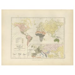
Antique Rain Map of the World by Johnston '1850'
Located in Langweer, NL
Antique map titled 'Hyetographic or Rain Map of the World'. Original antique rain map of the world. This map originates from 'The Physical Atlas of Natural Phenomena' by A.K. Johnsto...
Category
Antique Mid-19th Century Maps
Materials
Paper

Antique Ethnographic Map of the World by Johnston '1850'
Located in Langweer, NL
Antique map titled 'Ethnographic map of the world showing the present distribution of the leading races of man'. Original antique ethnographic map...
Category
Antique Mid-19th Century Maps
Materials
Paper
You May Also Like
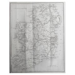
Original Antique Map of Ireland by Hughes. C.1850
Located in St Annes, Lancashire
Great map of Ireland
Engraved by W.Hughes
Published by Virtue, C.1850
Unframed.
Category
Antique 1850s Scottish Other Maps
Materials
Paper
Original Antique Map of Scotland by Becker. C.1850
Located in St Annes, Lancashire
Great map of Scotland
Engraved by F.P Becker
Published by Virtue, C.1850
Unframed.
Category
Antique 1850s Scottish Other Maps
Materials
Paper

Original Antique Map of Asia. C.1780
Located in St Annes, Lancashire
Great map of Asia
Copper-plate engraving
Published C.1780
Two small worm holes to right side of map
Unframed.
Category
Antique Early 1800s English Georgian Maps
Materials
Paper

Original Antique Map / City Plan of Brussels by Tallis, circa 1850
Located in St Annes, Lancashire
Great map of Brussels.
Steel engraving.
Published by London Printing & Publishing Co. (Formerly Tallis), C.1850
Free shipping.
Category
Antique 1850s English Maps
Materials
Paper

Original Antique Map of South East Asia by Becker, circa 1840
Located in St Annes, Lancashire
Great map of South East Asia
Steel engraving with original color outline
Engraved by Becker
Published by Virtue, circa 1840.
Unframed.
Category
Antique 1840s English Other Maps
Materials
Paper

Original Antique Map of South East Asia by Thomas Clerk, 1817
Located in St Annes, Lancashire
Great map of South East Asia
Copper-plate engraving
Drawn and engraved by Thomas Clerk, Edinburgh.
Published by Mackenzie And Dent, 1817
Unframed.
Category
Antique 1810s English Maps
Materials
Paper

Recently Viewed
View AllMore Ways To Browse
Antique Mountain Maps
Antique Town Maps
Antique Map England
Antique Map Of America
Antique Map Of England
Antique Maps Of England
Sea Map
Used Furniture Edinburgh
Antique French 18th Century Map
17th Century World Map
Antique Sea Maps
Antique 17th Century World Map
Antique City Plans
India Map
China Map
Map Of China
Map Spain
Maps Spain