Items Similar to Antique Map of Northern Ireland by Mercator/Hondius, Early 1600's


Want more images or videos?
Request additional images or videos from the seller
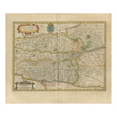
Antique Map of Northern Ireland by Mercator/Hondius, Early 1600's
About the Item
Antique map titled 'Ultoniae Orientalis Pars'. Original antique map of Northern Ireland. Published by Mercator/Hondius, ca. 1600.
Superb early map of the eastern part of Ulster, featuring Down and Antrim Counties in Northern Ireland. Mercator's famous moire pattern in the sea is used. Strong topographical features in the interior and ornamented with a title cartouche incorporating the distance scale.
This was one of five Irish maps Gerard Mercator designed for the second part of his Atlas. The other maps are: Carlow, Munster; Connaught and Ulster (general map).
Gerard Mercator (1512-1594) was an accomplished mathematician, cartographer, globe maker and engraver but is best known for the Mercator Projection. Incorporating the newly accepted fact that the world is round, Mercator was able to render longitude lines consistently straight on a chart. Although this requires some distortion, it was of great use for navigators, and is historically important, as it is still the most commonly used projection today. Originally created by Mercator, this plate was later added to by Hondius.
Date of first edition: 1595 (Mercator) - Date of this edition: a Latin edition: 1607 or, 1611 or, 1613 or, 1623, or 1630. Latin text on verso.
Henricus Hondius (1597-1651) was a Dutch engraver and mapmaker, a member of a prominent cartographic family. His father, Jodocus Hondius, was also an engraver and geographer. While working with his father, Henricus was instrumental in the expansion and republishing of Mercator’s atlas, first published in 1595 and republished by Hondius in 1606.
Upon his father’s death in 1612, Henricus and his brother, Jodocus the Younger, took over the business. He set up his own shop in 1621, where he continued to release new editions of the Mercator atlas. Later, he partnered with his brother-in-law, Jan Janssonius, in continuing to expand and publish Mercator’s atlas, which would become known as the Mercator-Hondius-Janssonius atlas. Born and based in Amsterdam, he died there in 1651.
Condition: A nice old hand colored map with no damage or holes in the image and only in the very outside of the white margins a few small creases, two repaired, on verso. The centerfold is visible and supported on the verso with archival tape. A very beautiful map in orginal colors.
- Dimensions:Height: 18.12 in (46 cm)Width: 21.66 in (55 cm)Depth: 0.02 in (0.5 mm)
- Materials and Techniques:
- Period:
- Date of Manufacture:1600
- Condition:General age-related toning. Original folding line. Please study images carefully.
- Seller Location:Langweer, NL
- Reference Number:
About the Seller
5.0
Platinum Seller
These expertly vetted sellers are 1stDibs' most experienced sellers and are rated highest by our customers.
Established in 2009
1stDibs seller since 2017
1,956 sales on 1stDibs
Typical response time: <1 hour
- ShippingRetrieving quote...Ships From: Langweer, Netherlands
- Return PolicyA return for this item may be initiated within 14 days of delivery.
More From This SellerView All
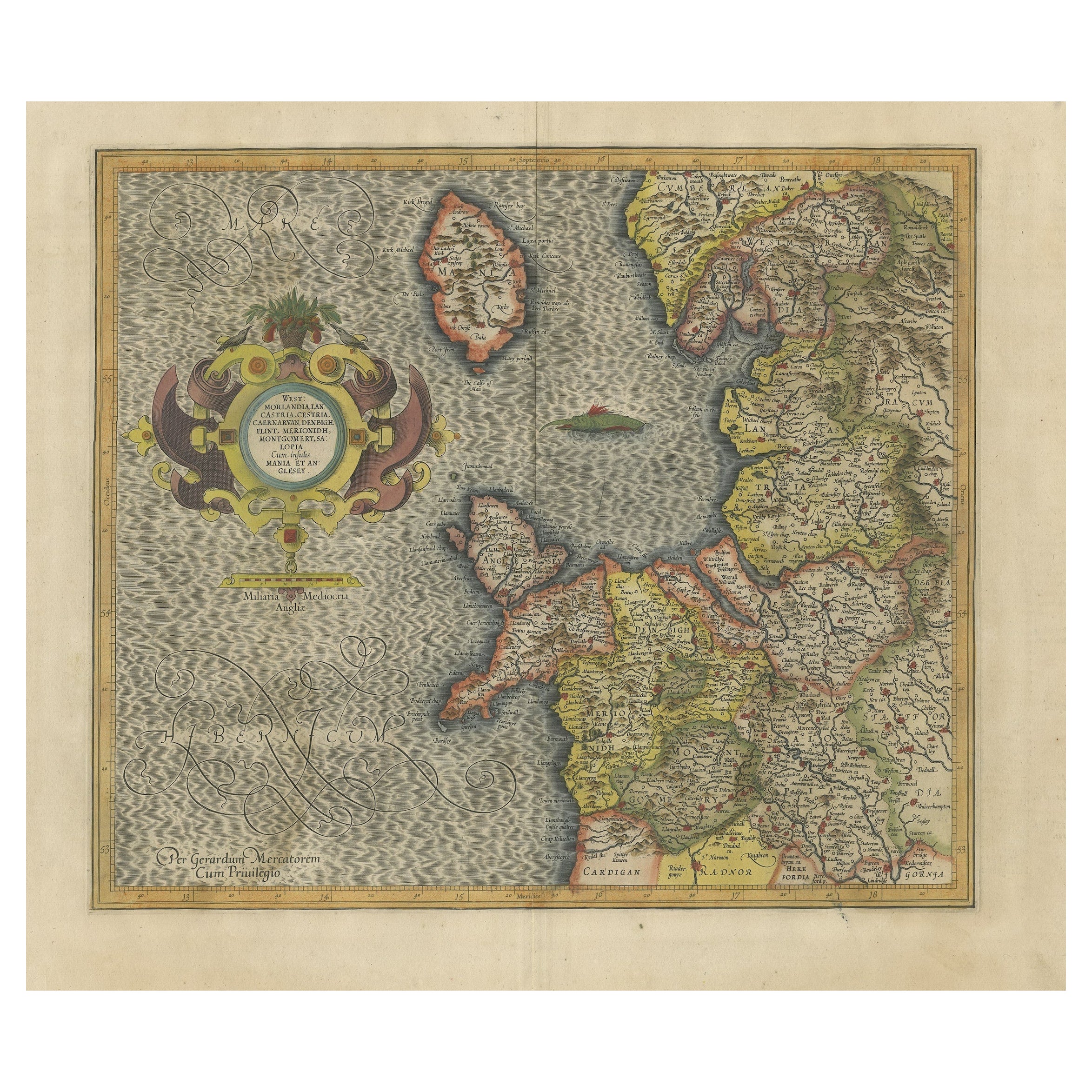
- Antique Map of England by Mercator/Hondius, circa 1600Located in Langweer, NLAntique map titled 'Westmorlandia, Lancastria, Caernvan, Denbigh, Flint, Merionidh, Dalopia cum issulis Mania et Anglesey'. Original antique map of England...Category
Antique 16th Century Maps
MaterialsPaper
- Antique Map of Westfalia, Germany by Mercator/Hondius, circa '1620'Located in Langweer, NLAntique map titled 'Westfalia cum dioecelsi Bremensi'. Original antique map of Germany. Published by Mercator/Hondius, circa '1620' 17th Century antique detailled map of Westphali...Category
Antique 16th Century Maps
MaterialsPaper
- Antique Map of Styria by Mercator 'circa 1650'Located in Langweer, NLAntique map titled 'Stiria'. Original antique map of Styria, Austria. Published by G. Mercator, circa 1650.Category
Antique Mid-17th Century Maps
MaterialsPaper
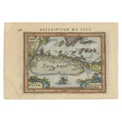
- Antique Miniature Map of Java by Bertius/Hondius '1618'Located in Langweer, NLRare antique miniature map titled 'Iava Maior'. This map shows the northern coastline of Java (Indonesia) with numerous place names, but the southern coa...Category
Antique Early 17th Century Maps
MaterialsPaper
- Antique Map of the Region of Lyon by Hondius, circa 1630Located in Langweer, NLAntique map titled 'Lionnois, Forest et Beauiolois'. Old map of the former region of Lyon, Vienne, Bresse, Rohan and the Rhône River. This map originates f...Category
Antique Mid-17th Century Maps
MaterialsPaper
- Antique Map of the Region of Bresse by Hondius, circa 1630Located in Langweer, NLAntique map titled 'Bresse'. Old map of the former region of Bresse, France. It is located in the regions of Auvergne-Rhône-Alpes and Bourgogne-Franche-Comté of eastern France. This ...Category
Antique Mid-17th Century Maps
MaterialsPaper


You May Also Like
- Southeastern Ireland: A 17th Century Hand Colored Map by Mercator and HondiusBy Gerard MercatorLocated in Alamo, CAA 17th century copperplate hand-colored map entitled "The Second Table of Ireland, Udrone" by Gerard Mercator and Jodocus Hondius, published in Amsterdam in 1635 in 'Cosmographicall ...Category
Antique Mid-17th Century Dutch Maps
MaterialsPaper
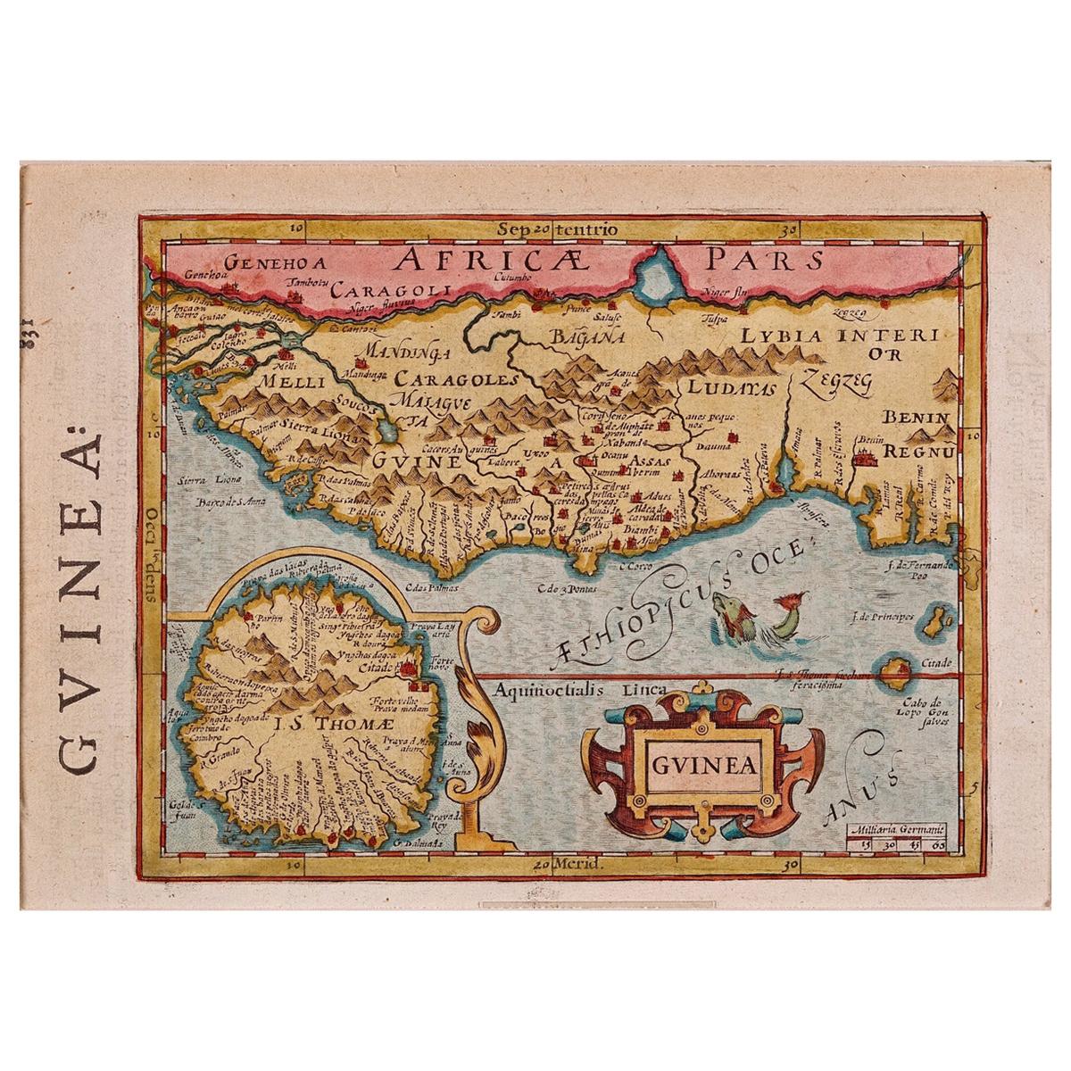
- 17th Century Hand-Colored Map of West Africa by Mercator/HondiusLocated in Alamo, CAA 17th century hand-colored map entitled "Guineae Nova Descriptio" by Gerard Mercator and Jodocus Hondius, published in their 'Atlas Minor' in Amsterdam in 1635. It is focused on the...Category
Antique Mid-17th Century Dutch Maps
MaterialsPaper
- 17th Century Hand-Colored Map of Southeastern England by Mercator and HondiusBy Gerard MercatorLocated in Alamo, CAA 17th century copperplate hand-colored map entitled "The Sixt Table of England" by Gerard Mercator and Jodocus Hondius, published in Amsterdam in 1635 in 'Cosmographicall Descriptio...Category
Antique Mid-17th Century Dutch Maps
MaterialsPaper
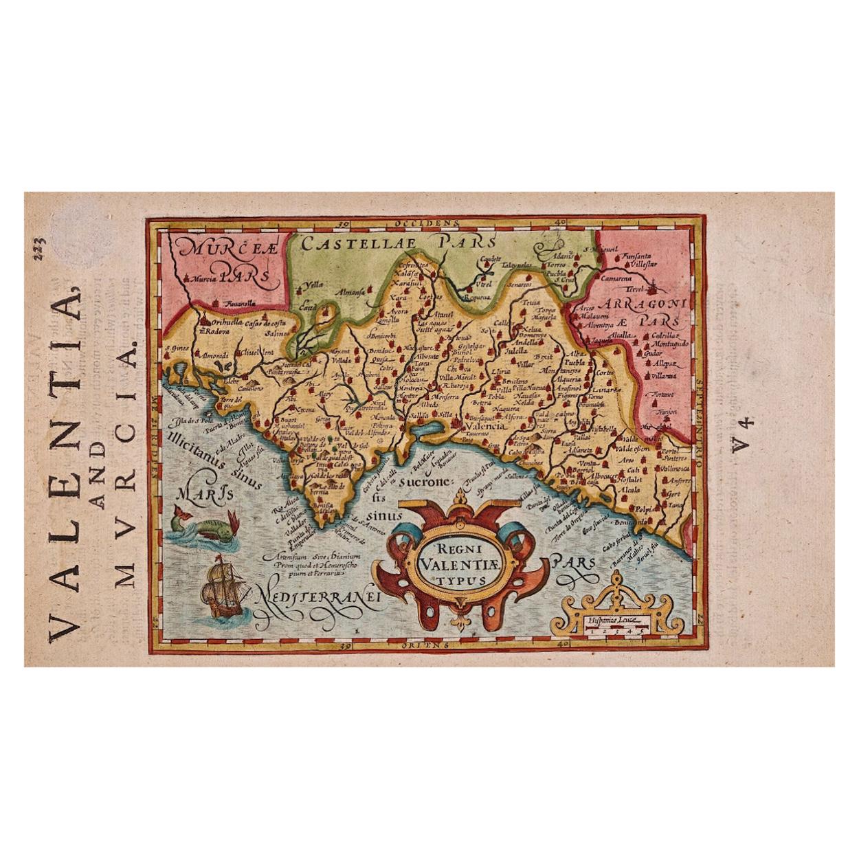
- 17th Century Hand-Colored Map of Valencia and Murcia, Spain by Mercator/HondiusBy Gerard MercatorLocated in Alamo, CAA 17th century hand-colored map entitled "Regni Valentiae Typus, Valentia and Murcia" by Gerard Mercator and Joducus Hondius, published in Amsterdam in 1635 in 'Cosmographicall Descr...Category
Antique Mid-17th Century Dutch Maps
MaterialsPaper
- Northern Scotland: A 17th Century Hand-colored Map by MercatorBy Gerard MercatorLocated in Alamo, CAThis is a framed hand-colored 17th century map of Northern Scotland by Gerard Mercator entitled "Scotiae pars Septentrionalis", published in Amsterdam in 1636. It is a highly detailed map of the northern part of Scotland, with the northwest Highlands and the cities Inverness and Aberdeen, as well as the Orkney Islands and the Hebrides. There is a decorative title cartouche in the upper left corner. The map is presented in an antiqued brown wood...Category
Antique 1630s Dutch Maps
MaterialsPaper
- Northern Scotland: A 16th Century Hand-colored Map by MercatorBy Gerard MercatorLocated in Alamo, CAA framed hand-colored 16th century map of Northern Scotland by Gerard Mercator entitled "Scotiae pars Septentrionalis", published in Amsterdam in 1636. It is a highly detailed map of the northern part of Scotland, with the northwest Highlands and the cities Inverness and Aberdeen, as well as the Orkney Islands and the Hebrides. There is a decorative title cartouche in the upper left corner. The map is presented in an antiqued brown wood...Category
Antique 16th Century Dutch Maps
MaterialsPaper


Recently Viewed
View AllMore Ways To Browse
Antique Globes Of The World
Great Northern
Antique Shop Collectables
1600S Antique
Scale Map
Ireland Plate
Irish Plates
Set Of Maps
Northern Ireland
Antique Curiosity Shop
Used Furniture Northern Ireland
Topographical Map
World Map Globe
Antique Northern Ireland
Antique 1600s
Antique Furniture Northern Ireland
Antique 16th Century Plates
Antique Topographic Maps