Items Similar to Antique Map of Puerto San Julian in Patagonia, 1749


Want more images or videos?
Request additional images or videos from the seller
1 of 7
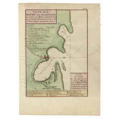
Antique Map of Puerto San Julian in Patagonia, 1749
About the Item
Antique map titled 'Plan van de Haven van St. Juliaan op de Kust van Patagonia (..) - Plan du Port St. Julien, sur la Côte des Patagons (..)'. Original antique map of St. Julian on the Patagonia / Argentina coast with the ships that were part of the voyage of George Anson around the world. Puerto San Julian is a natural harbour in Patagonia in the Santa Cruz Province of Argentina. This map originates from 'Reize rondsom de Werreld (..)' by George Anson, published 1749. Artists and Engravers: Admiral of the Fleet George Anson, 1st Baron Anson, PC, FRS (23 April 1697 - 6 June 1762) was a Royal Navy officer.
Artist: Admiral of the Fleet George Anson, 1st Baron Anson, PC, FRS (23 April 1697 - 6 June 1762) was a Royal Navy officer.
Condition: Good, general age-related toning. Minor wear, some foxing. Blank verso, please study image carefully.
Date: 1749
Overall size: 21 x 26.5 cm.
Image size: 0.001 x 16 x 21 cm.
Antique prints have long been appreciated for both their aesthetic and investment value. They were the product of engraved, etched or lithographed plates. These plates were handmade out of wood or metal, which required an incredible level of skill, patience and craftsmanship. Whether you have a house with Victorian furniture or more contemporary decor an old engraving can enhance your living space.
- Dimensions:Height: 10.44 in (26.5 cm)Width: 8.27 in (21 cm)Depth: 0 in (0.01 mm)
- Materials and Techniques:
- Period:
- Date of Manufacture:1749
- Condition:Condition: Good, general age-related toning. Minor wear, some foxing. Blank verso, please study image carefully.
- Seller Location:Langweer, NL
- Reference Number:
About the Seller
5.0
Platinum Seller
These expertly vetted sellers are 1stDibs' most experienced sellers and are rated highest by our customers.
Established in 2009
1stDibs seller since 2017
1,940 sales on 1stDibs
Typical response time: <1 hour
- ShippingRetrieving quote...Ships From: Langweer, Netherlands
- Return PolicyA return for this item may be initiated within 14 days of delivery.
More From This SellerView All
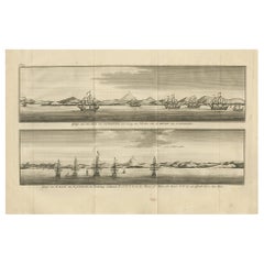
- Antique Print with Views of San Julian in Patagonia, 1749Located in Langweer, NLAntique print titled 'De rivier van St. Juliaan (..) - De haven van Sint Juliaan (..)'. Views of San Julian, Patagonia, Argentina. This print originates from 'Reize rondsom de Werrel...Category
Antique 18th Century Prints
MaterialsPaper
- Antique Print with Views of St. Julian, Patagonia, 1749Located in Langweer, NLAntique print titled 'Gezigt van het land van Patagonia een weining ten noorden van de Haven van St. Juliaan.' and 'Gezigt van de Baay van St. Juliaan, de Woudsberg strekkende W.Z.W....Category
Antique Mid-18th Century Prints
MaterialsPaper
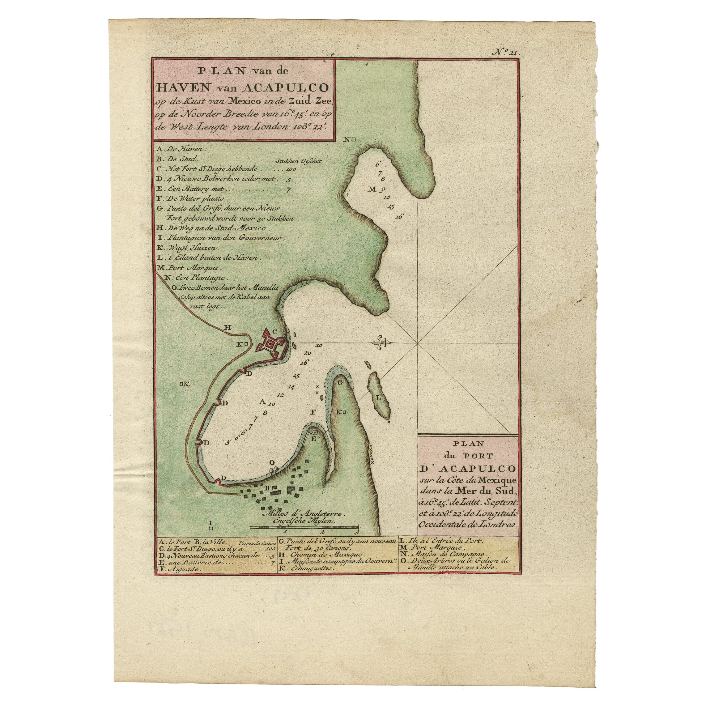
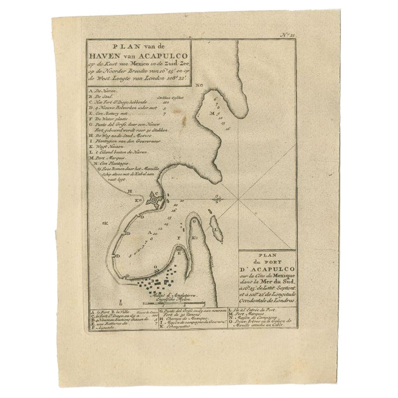
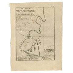
- Antique Map of The Harbour of Acapulco in Mexico, 1749Located in Langweer, NLDescription: Antique map titled 'Plan van de Haven van Acapulco (..) - Plan du Port d'Acapulco (..)'. Original antique map of the Port of Acapulco on the coast of Mexico in the South...Category
Antique 1740s Maps
MaterialsPaper
- Antique Map of the Region of Zeitz in Germany, 1749By SchreiberLocated in Langweer, NLAntique map titled 'Das Stifft Zeitz (..)'. Map of the region of Zeitz, Germany. Zeitz is a town in the Burgenlandkreis district, in Saxony-Anhalt, Germany. It is situated on the riv...Category
Antique 18th Century Maps
MaterialsPaper
- Antique Map of the Region of Gommern in Germany, 1749By SchreiberLocated in Langweer, NLAntique map titled 'Das Amt Gommern und die Graffschafft Barby (..)'. Map of the region of Gommern, Germany. This map originates from 'Atlas Selectus von allen Konigreichen und Lande...Category
Antique 18th Century Maps
MaterialsPaper
- Antique Map of the Port of Acapulco in Mexico, 1749Located in Langweer, NLAntique map titled 'Plan van de Haven van Acapulco (..) - Plan du Port d'Acapulco (..)'. Original antique map of the Port of Acapulco on the coast of Mexico in the Southern Sea, at 1...Category
Antique 18th Century Maps
MaterialsPaper

You May Also Like
- "San Francisco, Upper California” 1851 Antique Map of San FranciscoLocated in Colorado Springs, COThis is a pictorial lettersheet view of the city and harbor of San Francisco. This lithograph was printed on grey wove paper, across a double sheet, by famed lithographers Britton & ...Category
Antique 1850s American Prints
MaterialsPaper
- Map Kyle Carrick Aireshire Thomas Kitchen 1749By Thomas KitchinLocated in BUNGAY, SUFFOLKA Map of Kyle & Carrick Aireshire Thomas Kitchen 1749 In original black and gold frame Just purchased more information to follow MAKER Thomas Kitchin (1718-1784) English engrave...Category
Antique 18th Century English Georgian Maps
MaterialsPaper
- Antique Map of Principality of MonacoBy Antonio Vallardi EditoreLocated in Alessandria, PiemonteST/619 - "Old Geographical Atlas of Italy - Topographic map of ex-Principality of Monaco" - ediz Vallardi - Milano - A somewhat special edition ---Category
Antique Late 19th Century Italian Other Prints
MaterialsPaper
- Geographical Antique Map of Principality of MonacoBy Bruno SantiniLocated in Alessandria, PiemonteST/609 - Interesting antique color map of Monaco Principality in French language : "Carte qui contient le Principauté de Piémont, le Monferrat et la comté de...Category
Antique Late 18th Century Italian Other Maps
MaterialsPaper
- 1861 Topographical Map of the District of Columbia, by Boschke, Antique MapLocated in Colorado Springs, COPresented is an original map of Albert Boschke's extremely sought-after "Topographical Map of the District of Columbia Surveyed in the Years 1856 ...Category
Antique 1860s American Historical Memorabilia
MaterialsPaper
- 1907 Map of Colorado, Antique Topographical Map, by Louis NellLocated in Colorado Springs, COThis highly detailed pocket map is a topographical map of the state of Colorado by Louis Nell from 1907. The map "has been complied from all availabl...Category
Antique Early 1900s American Maps
MaterialsPaper


Recently Viewed
View AllMore Ways To Browse
April Antiques
Argentine Antiques
Antique Argentine
Argentine Antique Furniture
Antique World Map Print
George Map
Antique Pc
Fleet Furniture Antique
Engraving Navy
Antique Ship Decor
Santa Cruz Used Furniture
George Fleet
Antique Santa Plate
Argentina Map
Antique Victorian Santa
Antique Furniture Santa Cruz
Antique Map Argentina
Antique Map Of Argentina