Items Similar to Antique Map of the Region of Cologne and Liege by Scherer, 1699
Want more images or videos?
Request additional images or videos from the seller
1 of 5
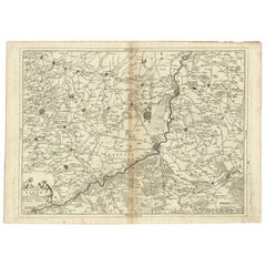
Antique Map of the Region of Cologne and Liege by Scherer, 1699
About the Item
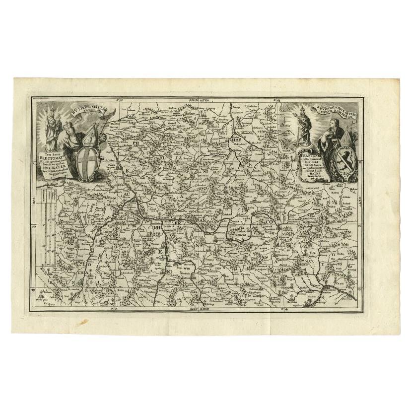
Antique map titled 'Archpiescopatus Coloniensis (..) Episcopatus Leodiensis (..).' Detailed uncommon map of the Archbishopric of Cologne and the Bishopric of Liege/Luik. Source unknown, to be determined.
Artists and Engravers: Heinrich Scherer (1628-1704) was a Professor of Hebrew, Mathematics and Ethics at the University of Dillingen until about 1680. Thereafter he obtained important positions as Official Tutor to the Royal Princes of Mantua and Bavaria. It was during his time in Munich as Tutor to the Princely house of Bavaria that his lifetime’s work as a cartographer received acclaim and recognition. Scherer’s world atlas, the Atlas Novus, first published in Munich between 1702 and 1710 and reissued in a second edition between 1730 and 1737, forms a singularly unusual, almost revolutionary work in terms of the development of European mapmaking at the beginning of the 18th Century.
Condition: Very good, given age. Original folds as issued. General age-related toning and/or occasional minor defects from handling. Please study image carefully.
Date: 1699
Overall size: 40.5 x 27.3 cm.
Image size: 35.3 x 23 cm.
We sell original antique maps to collectors, historians, educators and interior decorators all over the world. Our collection includes a wide range of authentic antique maps from the 16th to the 20th centuries. Buying and collecting antique maps is a tradition that goes back hundreds of years. Antique maps have proved a richly rewarding investment over the past decade, thanks to a growing appreciation of their unique historical appeal. Today the decorative qualities of antique maps are widely recognized by interior designers who appreciate their beauty and design flexibility. Depending on the individual map, presentation, and context, a rare or antique map can be modern, traditional, abstract, figurative, serious or whimsical. We offer a wide range of authentic antique maps for any budget.
- Dimensions:Height: 10.75 in (27.3 cm)Width: 15.95 in (40.5 cm)Depth: 0 in (0.01 mm)
- Materials and Techniques:
- Period:
- Date of Manufacture:1699
- Condition:
- Seller Location:Langweer, NL
- Reference Number:
About the Seller
5.0
Platinum Seller
These expertly vetted sellers are 1stDibs' most experienced sellers and are rated highest by our customers.
Established in 2009
1stDibs seller since 2017
1,948 sales on 1stDibs
Typical response time: <1 hour
- ShippingRetrieving quote...Ships From: Langweer, Netherlands
- Return PolicyA return for this item may be initiated within 14 days of delivery.
More From This SellerView All
- Antique Map of the Franconia Region by Scherer, 1699Located in Langweer, NLAntique map titled 'Franconia multa numerat loca deiparae sacra in quibus magna recipit à dei matre beneficia.' Detailed uncommon map of the Franconia region in Germany. Source unkno...Category
Antique 17th Century Maps
MaterialsPaper
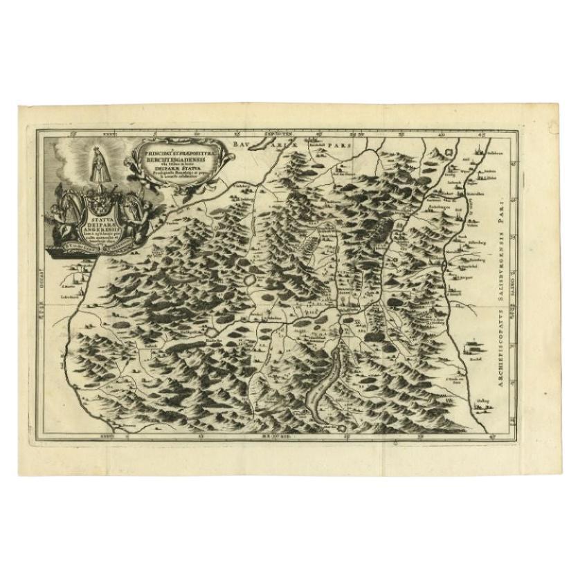
- Antique Map of the Berchtesgaden Region by Scherer, 1699Located in Langweer, NLAntique map titled 'Principat et praepositura Berchtesgadensis (..).' Detailed uncommon map of the Berchtesgaden region in southern Bavaria, Germany. Source unknown, to be determined...Category
Antique 17th Century Maps
MaterialsPaper
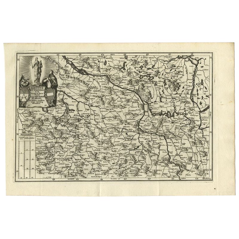
- Antique Map of Saxony and Westphalia by Scherer, 1699Located in Langweer, NLAntique map titled 'Saxonia et Westphalia varijs in locis sacris erga dei matre est officiosa & ipsa vicissim erga utramq. Munifica.' Detailed uncommon map of Saxony and Westphalia i...Category
Antique 17th Century Maps
MaterialsPaper
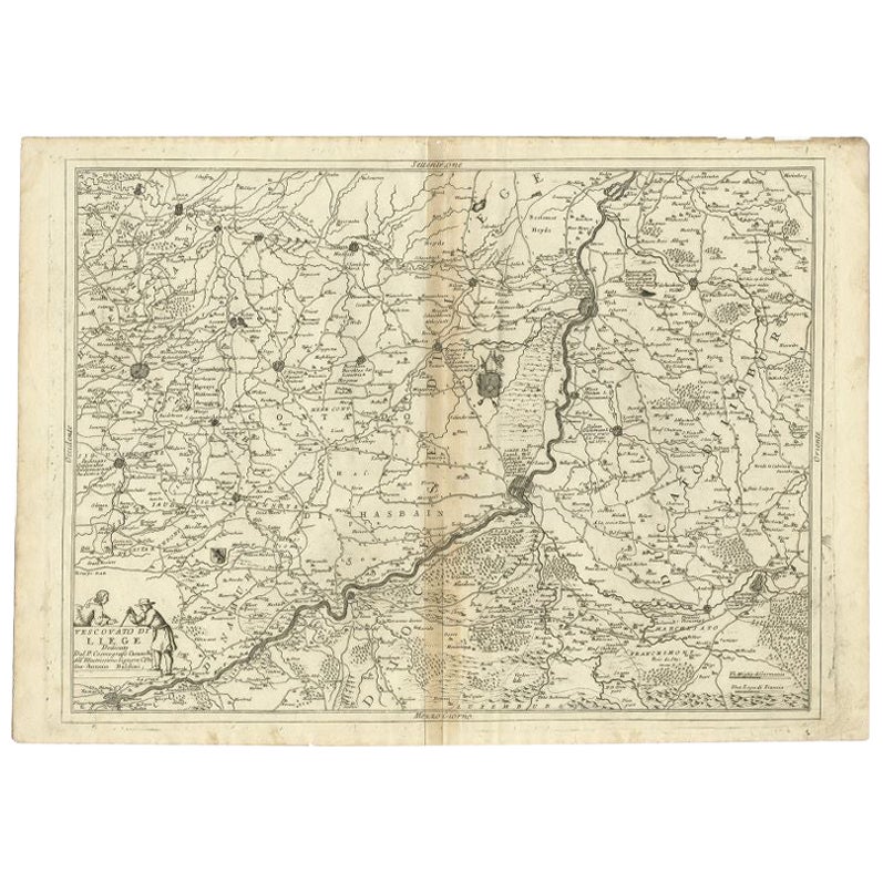
- Antique Map of the Region of Liege by Coronelli, 1690By Vincenzo CoronelliLocated in Langweer, NLAntique map titled 'Vescovato di Liege (..)'. Map of the Belgium area centered on Liege and the course of Meuse/Maas River. Also depicts the cities of Maastricht, Namur and Tienen. O...Category
Antique 17th Century Maps
MaterialsPaper
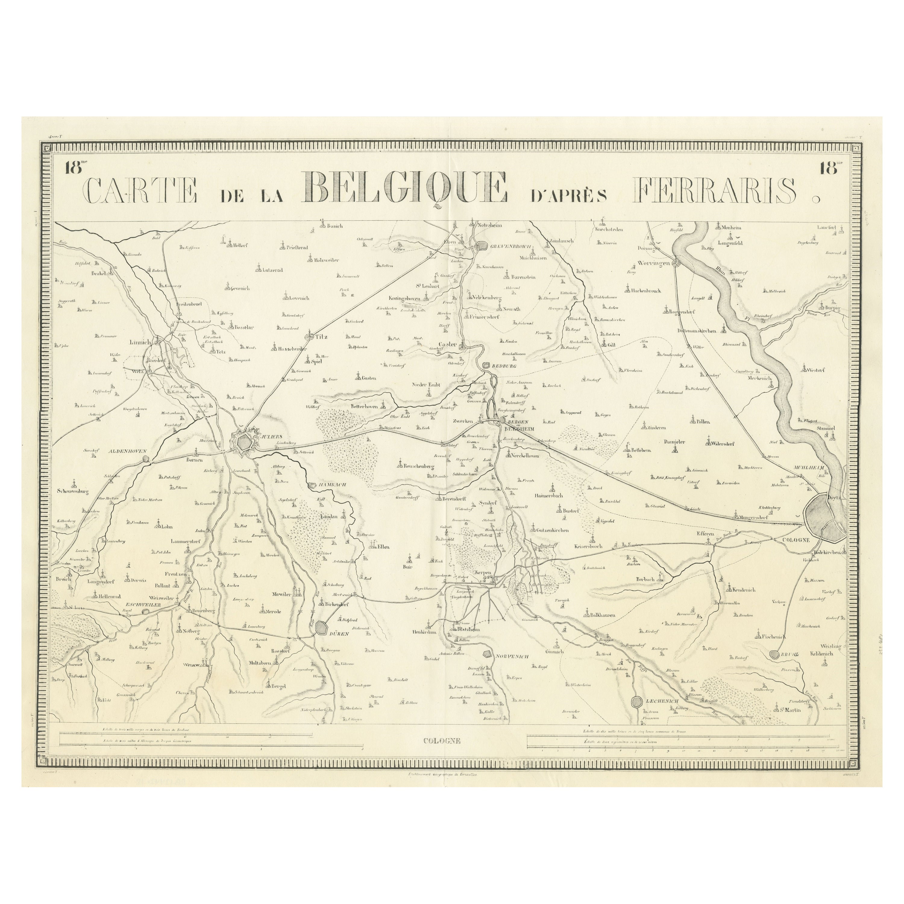
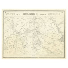
- Antique Map of the Region near Cologne, GermanyLocated in Langweer, NLAntique map titled 'Carte de la Belgique d'après Ferraris'. Original antique map of the region near Cologne, Germany. Cologne is the largest city of the German western state of North...Category
Antique Mid-19th Century Maps
MaterialsPaper
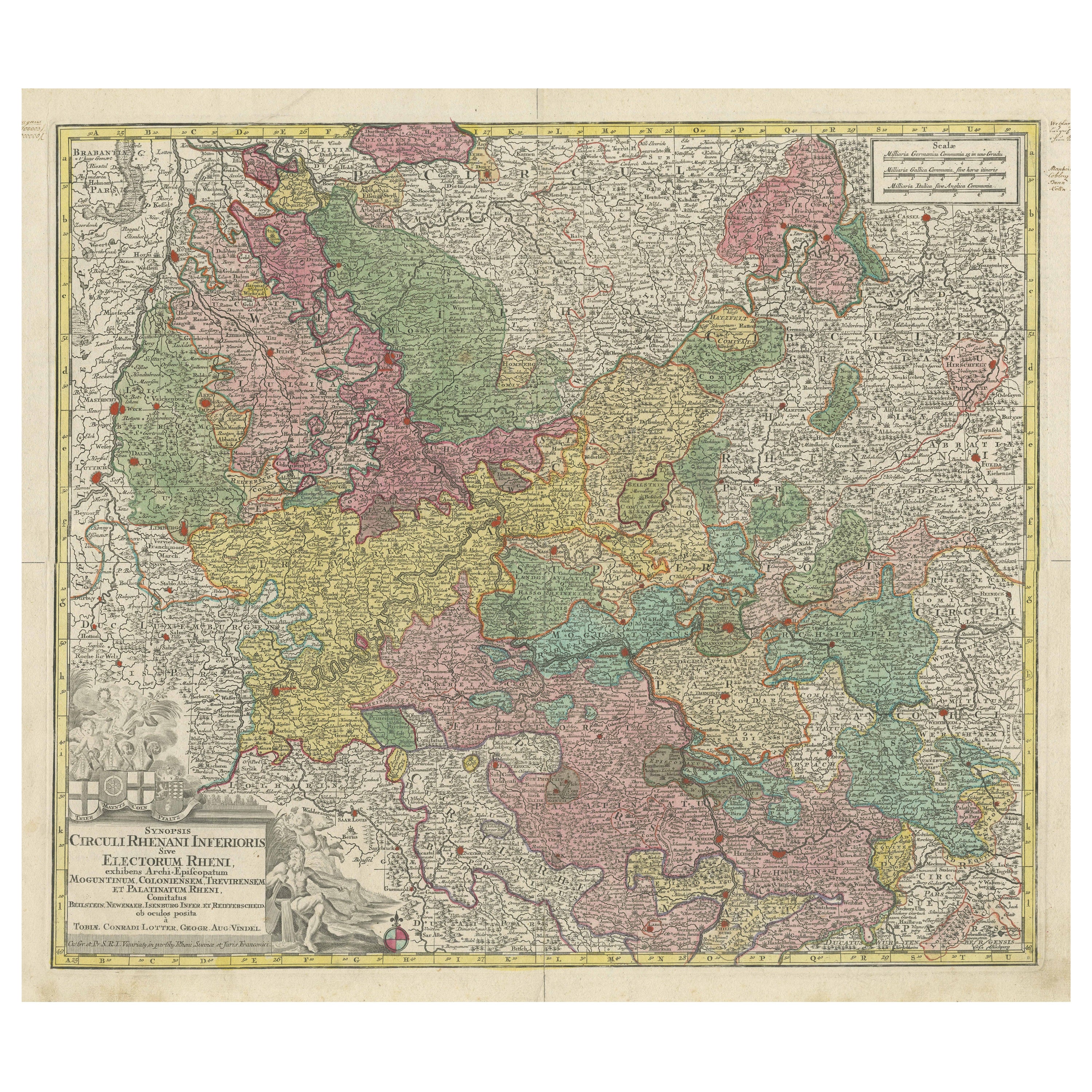
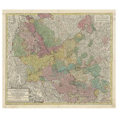
- Antique Map of the region of Trier, Mainz and Cologne, GermanyLocated in Langweer, NLAntique map titled 'Synopsis Circuli Rhenani Inferioris sive Electorum Rheni (..)'. Original antique map of the region of Trier, Mainz and Cologne, Germany. Published by T.C. Lotter,...Category
Antique Late 18th Century Maps
MaterialsPaper

You May Also Like
- 17th Century Hand Colored Map of the Liege Region in Belgium by VisscherBy Nicolaes Visscher IILocated in Alamo, CAAn original 17th century map entitled "Leodiensis Episcopatus in omnes Subjacentes Provincias distincté divisusVisscher, Leodiensis Episcopatus" by Nicolaes Visscher II, published in Amsterdam in 1688. The map is centered on Liege, Belgium, includes the area between Antwerp, Turnhout, Roermond, Cologne, Trier and Dinant. This attractive map is presented in a cream-colored mat measuring 30" wide x 27.5" high. There is a central fold, as issued. There is minimal spotting in the upper margin and a tiny spot in the right lower margin, which are under the mat. The map is otherwise in excellent condition. The Visscher family were one of the great cartographic families of the 17th century. Begun by Claes Jansz Visscher...Category
Antique Late 17th Century Dutch Maps
MaterialsPaper
- The Normandy Region of France: A 17th C. Hand-colored Map by Sanson and JaillotBy Nicolas SansonLocated in Alamo, CAThis large hand-colored map entitled "Le Duché et Gouvernement de Normandie divisée en Haute et Basse Normandie en divers Pays; et par evêchez, avec le Gouvernement General du Havre ...Category
Antique 1690s French Maps
MaterialsPaper
- 1861 Topographical Map of the District of Columbia, by Boschke, Antique MapLocated in Colorado Springs, COPresented is an original map of Albert Boschke's extremely sought-after "Topographical Map of the District of Columbia Surveyed in the Years 1856 ...Category
Antique 1860s American Historical Memorabilia
MaterialsPaper
- 1594 Maurice Bouguereau Map of the Region Limoges, France, Ric0015Located in Norton, MA1594 Maurice Bouguereau map of the region Limoges, France, entitled "Totivs Lemovici et Confinium Pro Uinciarum Quantum ad Dioecefin Lemo Uicenfen Fpectant," Hand Colored Ric0015 Jean IV Le Clerc...Category
Antique 16th Century Dutch Maps
MaterialsPaper
- Original Antique Map of The World by Thomas Clerk, 1817Located in St Annes, LancashireGreat map of The Eastern and Western Hemispheres On 2 sheets Copper-plate engraving Drawn and engraved by Thomas Clerk, Edinburgh. Published by Mackenzie And Dent, 1817 ...Category
Antique 1810s English Maps
MaterialsPaper
- Sean Scherer’s Vignettes Book by Sean SchererLocated in New York, NYSean Scherer’s Vignettes By: Sean Scherer Designer, collector, and proprietor of the contemporary curiosity shop Kabinett & Kammer, Sean Scherer shares h...Category
21st Century and Contemporary Books
MaterialsPaper


Recently Viewed
View AllMore Ways To Browse
Antique Bavaria
Hebrew Antique
Heinrich Bavaria
Map Bavaria
Map Of Bavaria
Medieval Plate
Antique Depot
Kings Court
Large Framed Maps
Ships Log
Royal Carriage
Antique Map Australia
Australia Antique Map
Antique Australia Map
Antique Australian Map
Antique Maps Of Australia
Antique Map Of Australia
Antique Australian Maps