Items Similar to Antique Map of the Region of Elbogen & Eger, Czech Republic & Hungary, 1742


Want more images or videos?
Request additional images or videos from the seller
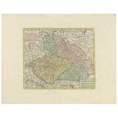
Antique Map of the Region of Elbogen & Eger, Czech Republic & Hungary, 1742
About the Item
Antique map titled 'Repraesentatio Geographica Circuli Egerani, nec non Elnbogensis : in quo simul viae Egeranae in Thermas Carolinas distincta delineatio conspicitur (..)'.
Original antique map of the region of Elbogen and Eger, Czech Republic/Hungary. Published 1742.
Artists and Engravers: Following the long period of Dutch domination, the Homann family became the most important map publishers in Germany in the eighteenth century, the business being founded by J.B. Homann in Nuremberg about the year 1702. Soon after publishing his first atlas in 1707 he became a member of the Berlin academy of Sciences and in 1715 he was appointed Geographer to the Emperor. After the founder's death in 1724, the firm was continued under the direction of his son until 1730 and was then bequeathed to his heirs on the condition that it trades under the name of Homann Heirs. The firm remained in being until the next century and had a wide influence on map publishing in Germany. Apart from the atlases the firm published a very large number of individual maps. The Homanns produced a Neuer Atlas in 1714, a Grosser Atlas in 1737, and an Atlas Maior with about 300 maps in 1780. They also issued a special Atlas of Germany with full sized plans of principal cities, school atlases and an Atlas of Silesia in 1750 with 20 maps.
- Dimensions:Height: 20.67 in (52.5 cm)Width: 23.04 in (58.5 cm)Depth: 0 in (0.02 mm)
- Materials and Techniques:
- Period:1740-1749
- Date of Manufacture:1742
- Condition:Wear consistent with age and use. Condition: Good, repair on folding line. Some marginal tears, please study image carefully.
- Seller Location:Langweer, NL
- Reference Number:
About the Seller
5.0
Platinum Seller
These expertly vetted sellers are 1stDibs' most experienced sellers and are rated highest by our customers.
Established in 2009
1stDibs seller since 2017
1,950 sales on 1stDibs
Typical response time: <1 hour
- ShippingRetrieving quote...Ships From: Langweer, Netherlands
- Return PolicyA return for this item may be initiated within 14 days of delivery.
More From This SellerView All
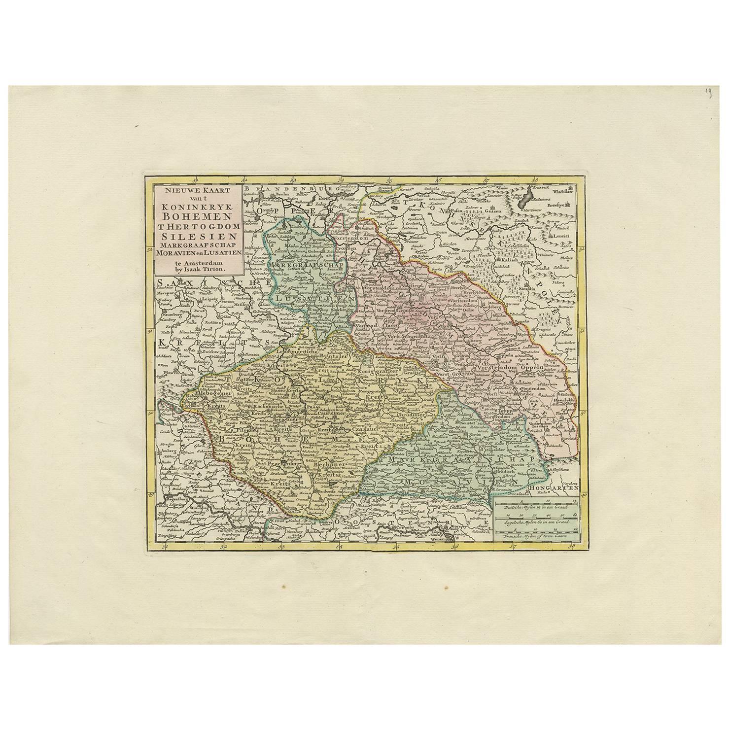
- Antique Map of Czech Republic by I. Tirion, 1747Located in Langweer, NLAntique map titled 'Nieuwe Kaart van t Koninkryk Bohemen t Hertogdom Silesien markgraafschap Moravien en Lusatien'. Including the towns of Berlin, Vienna, Regensburg.Category
Antique Mid-18th Century Maps
MaterialsPaper
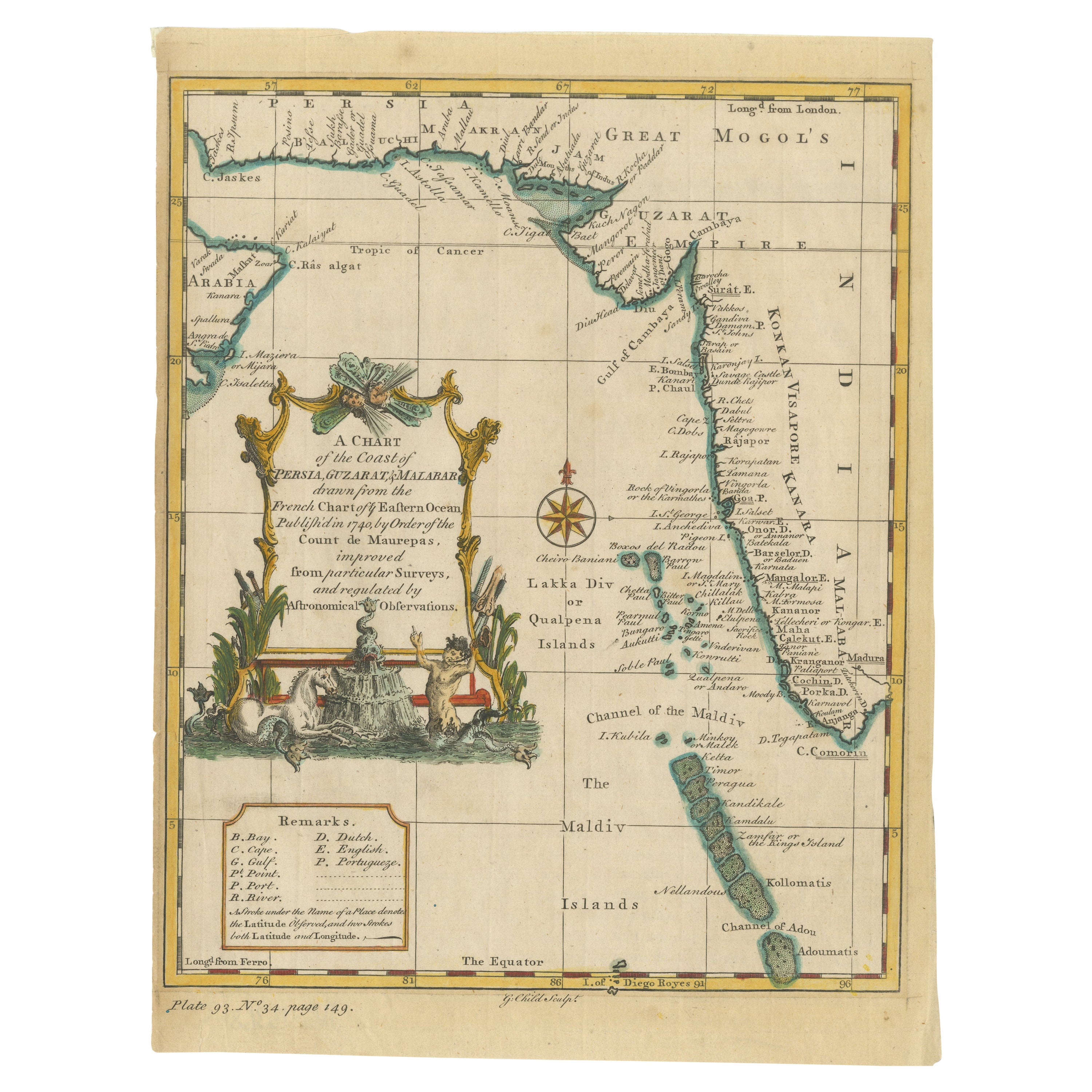
- Antique Map of the Region of the Arabian SeaLocated in Langweer, NLAntique map titled 'A Chart of the Coast of Persia, Guzarat & Malabar'. Old map centered on the Arabian Sea that shows some of the Persian Gulf and the Gulf of Oman, extending past P...Category
Antique Mid-18th Century Maps
MaterialsPaper
- Antique Map of the Region of Oldenburg, GermanyBy Willem BlaeuLocated in Langweer, NLAntique map titled 'Oldenburg Comitatus'. Detailed old map of Oldenburg, Germany. The map also shows Bremen and the Jade Bight. Published by W. Blaeu, circa 1640. Willem Jansz. Blaeu...Category
Antique Mid-17th Century Maps
MaterialsPaper
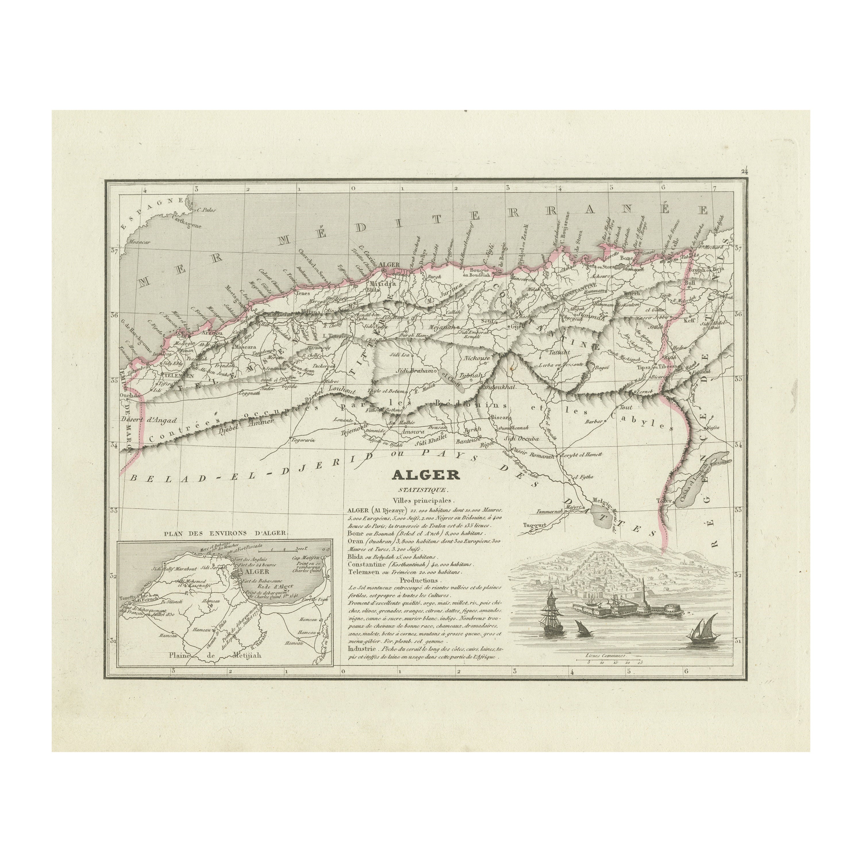
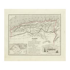
- Antique Map of the Region of Algiers, AlgeriaLocated in Langweer, NLAntique map titled 'Alger'. This map shows the region of Algiers, Algeria. With a small inset map of the region of Algiers and a decorative vignette with a harbor view. Originates fr...Category
Antique Mid-19th Century Maps
MaterialsPaper
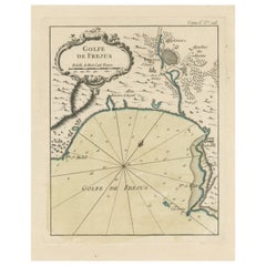
- Antique Map of the Region of Fréjus, FranceLocated in Langweer, NLTitle: "Golf de Fréjus" Description: This antique map, titled "Golf de Fréjus," is an original depiction of the region of Fréjus, France. It is part of the work "Le Petit Atlas Mari...Category
Antique Mid-18th Century Maps
MaterialsPaper
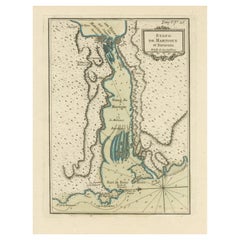
- Antique Map of the Region of Martigues, FranceLocated in Langweer, NLTitle: "Etang de Martigues et Environs: Antique Map of the Martigues Region, France" Description: This antique map, titled "Etang de Martigue et Environs," offers a detailed view of...Category
Antique Mid-18th Century Maps
MaterialsPaper


You May Also Like
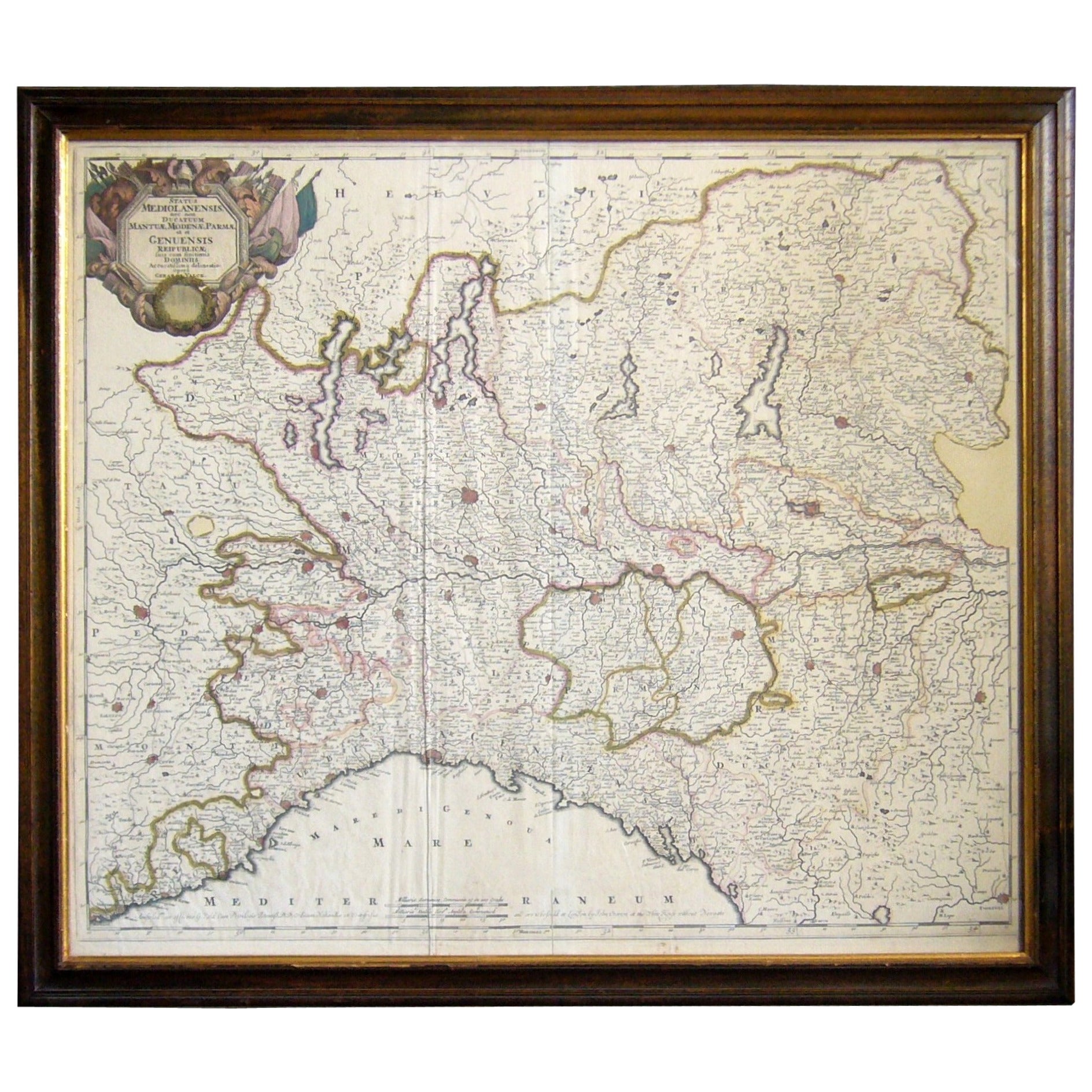
- Map of the Republic of GenoaLocated in New York, NYFramed antique hand-coloured map of the Republic of Genoa including the duchies of Mantua, Modena, and Parma. Europe, late 18th century. Dimension: 25...Category
Antique Late 18th Century European Maps
- Original Antique Map of Hungary, Arrowsmith, 1820Located in St Annes, LancashireGreat map of Hungary Drawn under the direction of Arrowsmith. Copper-plate engraving. Published by Longman, Hurst, Rees, Orme and Brown, 1820 Unframed.Category
Antique 1820s English Maps
MaterialsPaper
- 17th Century Hand Colored Map of the Liege Region in Belgium by VisscherBy Nicolaes Visscher IILocated in Alamo, CAAn original 17th century map entitled "Leodiensis Episcopatus in omnes Subjacentes Provincias distincté divisusVisscher, Leodiensis Episcopatus" by Nicolaes Visscher II, published in Amsterdam in 1688. The map is centered on Liege, Belgium, includes the area between Antwerp, Turnhout, Roermond, Cologne, Trier and Dinant. This attractive map is presented in a cream-colored mat measuring 30" wide x 27.5" high. There is a central fold, as issued. There is minimal spotting in the upper margin and a tiny spot in the right lower margin, which are under the mat. The map is otherwise in excellent condition. The Visscher family were one of the great cartographic families of the 17th century. Begun by Claes Jansz Visscher...Category
Antique Late 17th Century Dutch Maps
MaterialsPaper
- The Normandy Region of France: A 17th C. Hand-colored Map by Sanson and JaillotBy Nicolas SansonLocated in Alamo, CAThis large hand-colored map entitled "Le Duché et Gouvernement de Normandie divisée en Haute et Basse Normandie en divers Pays; et par evêchez, avec le Gouvernement General du Havre ...Category
Antique 1690s French Maps
MaterialsPaper
- Antique Map of Principality of MonacoBy Antonio Vallardi EditoreLocated in Alessandria, PiemonteST/619 - "Old Geographical Atlas of Italy - Topographic map of ex-Principality of Monaco" - ediz Vallardi - Milano - A somewhat special edition ---Category
Antique Late 19th Century Italian Other Prints
MaterialsPaper
- Original Antique Map of The World by Thomas Clerk, 1817Located in St Annes, LancashireGreat map of The Eastern and Western Hemispheres On 2 sheets Copper-plate engraving Drawn and engraved by Thomas Clerk, Edinburgh. Published by Mackenzie And Dent, 1817 ...Category
Antique 1810s English Maps
MaterialsPaper


Recently Viewed
View AllMore Ways To Browse
German And Hungarian Antique Furniture
Carolina Antique
Czech School
Dutch School Antique
Large City Maps
Antique School Maps
Antique School Map
Large Antique City Maps
Map Berlin
Berlin Maps
Large Original Antique City Plan
Hungary Map
Maps Hungary
Hungary Antique Map
Map Of Hungary
Carolina Map
Wood Carvings Of Ships
Classroom Furniture Used