Items Similar to Antique Map of the West Indies in Full Color, 1922


Want more images or videos?
Request additional images or videos from the seller
Antique Map of the West Indies in Full Color, 1922
About the Item
Antique map titled 'The West Indies.' A map of the West Indies, the Carribean region. This includes the Greater Antilles (Jamaica, Haiti, Puerto Rico and Cuba) and the Lesser Antilles (Leeward and Windward Islands) and part of the Bahama Islands. Inset maps show the Panama Canal, Kingston, Havana, Trinidad, Puerto Rico and Jamaica. Plate 96 from 'The Times Atlas'. Maps from the Edinburgh Geographical Institute, published by John Bartholomew & Co., 1922.
Artists and Engravers: Anonymous.
Condition: Good, given age. Original middle fold, as issued. A small nick and some creasing in the top and lower edges of the middle fold. General age-related toning and/or occasional minor defects from handling. Please study image carefully.
Date: 1922
Overall size: 57.8 x 44.7 cm.
Image size: 54.8 x 41.5 cm.
We sell original antique maps to collectors, historians, educators and interior decorators all over the world. Our collection includes a wide range of authentic antique maps from the 16th to the 20th centuries. Buying and collecting antique maps is a tradition that goes back hundreds of years. Antique maps have proved a richly rewarding investment over the past decade, thanks to a growing appreciation of their unique historical appeal. Today the decorative qualities of antique maps are widely recognized by interior designers who appreciate their beauty and design flexibility. Depending on the individual map, presentation, and context, a rare or antique map can be modern, traditional, abstract, figurative, serious or whimsical.
- Dimensions:Height: 17.6 in (44.7 cm)Width: 22.76 in (57.8 cm)Depth: 0 in (0.01 mm)
- Materials and Techniques:
- Period:
- Date of Manufacture:1922
- Condition:Condition: Good, given age. Original middle fold, as issued. A small nick and some creasing in the top and lower edges of the middle fold. General age-related toning and/or occasional minor defects from handling. Please study image carefully.
- Seller Location:Langweer, NL
- Reference Number:
About the Seller
5.0
Platinum Seller
These expertly vetted sellers are 1stDibs' most experienced sellers and are rated highest by our customers.
Established in 2009
1stDibs seller since 2017
1,950 sales on 1stDibs
Typical response time: <1 hour
- ShippingRetrieving quote...Ships From: Langweer, Netherlands
- Return PolicyA return for this item may be initiated within 14 days of delivery.
More From This SellerView All
- Antique Map of the West Indies by Wyld '1845'Located in Langweer, NLAntique map titled 'Map of the West India Islands'. Original antique map of the West Indies, including Cuba, the Bahamas, the Antilles a...Category
Antique Mid-19th Century Maps
MaterialsPaper
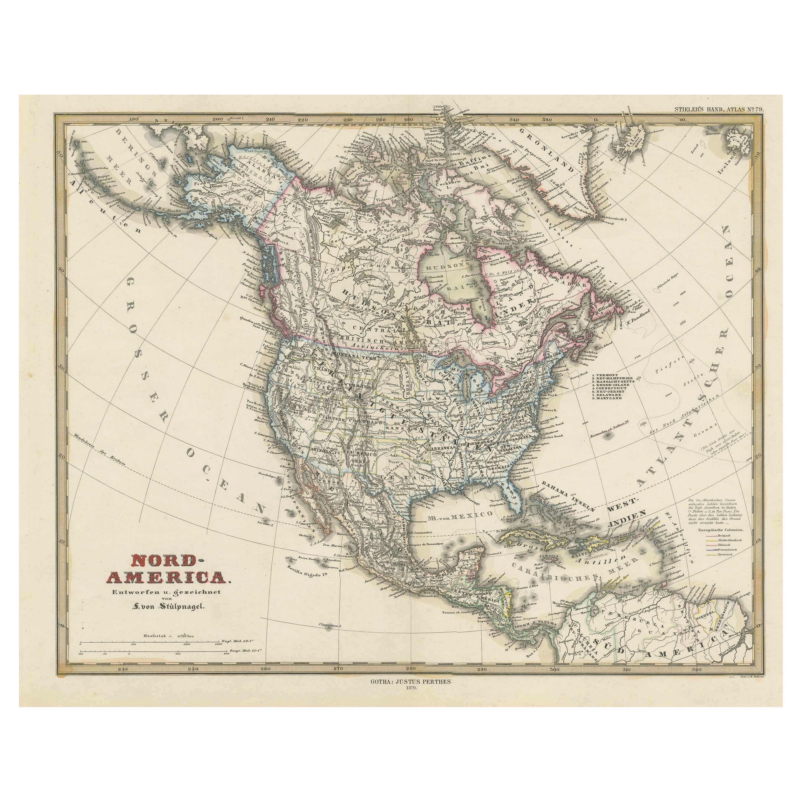
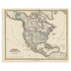
- Antique Map of North America Including the West IndiesLocated in Langweer, NLOriginal antique map titled 'Nord-America'. Old map of North America and the West Indies. Also showing British Overseas Territories and Hudson Bay. This map originates from Stiel...Category
Antique Mid-19th Century Maps
MaterialsPaper
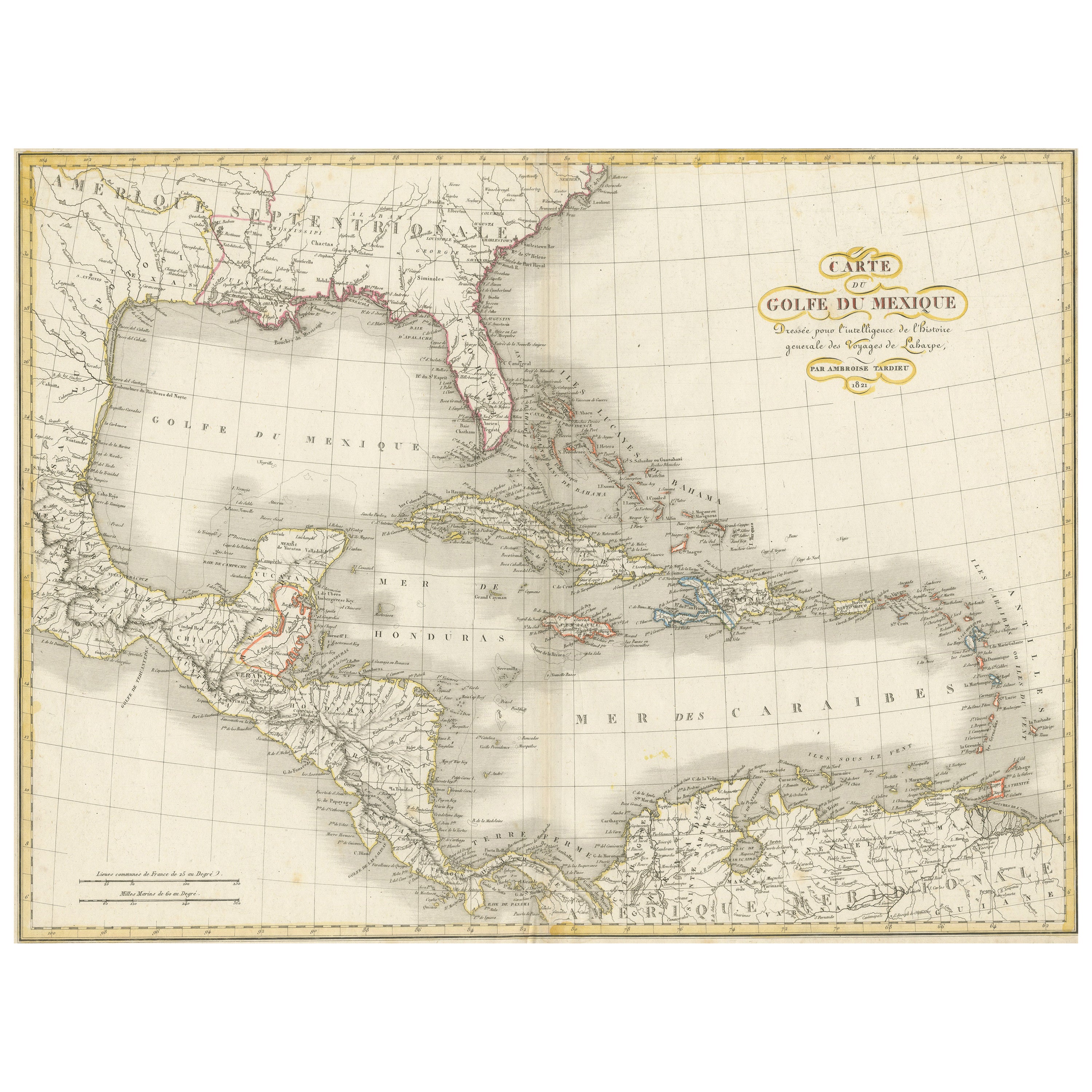
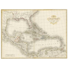
- Antique Map of the Gulf of Mexico and all the islands of the West IndiesLocated in Langweer, NLAntique map titled 'Carte du Golfe du Mexique'. This uncommon map depicts the Gulf of Mexico and all the islands of the West Indies. It also includes ni...Category
Antique Early 19th Century Maps
MaterialsPaper
- Antique Map of the West Indies and Central America by Lowry '1852'Located in Langweer, NLAntique map titled 'West Indies and Central America'. Original map of the West Indies and Central America. This map originates from 'Lowry's Table Atlas constructed and engraved from...Category
Antique Mid-19th Century Maps
MaterialsPaper
- Antique Map of the West Indies and Central America by W. G. Blackie, 1859Located in Langweer, NLAntique map titled 'The West India Island & Central America'. Original antique map of the West Indies and Central America, with inset map of Jamaica. Th...Category
Antique Mid-19th Century Maps
MaterialsPaper
- Antique Map with Hand Coloring of North America and the West IndiesLocated in Langweer, NLOriginal antique map titled 'Nord-America'. Old map of North America and the West Indies. This map originates from Stielers Handatlas, published circa 1879. Stielers Handatlas (a...Category
Antique Late 19th Century Maps
MaterialsPaper


You May Also Like
- Cricket Print, England v. West Indies at the Oval, by Arthur WeaverBy Arthur WeaverLocated in Oxfordshire, GB1990's Arthur Weaver Oval Cricket Ground Print, England v West Indies. A colourful cricket lithograph signed by the artist, Arthur Weaver, of the 'Final Test' at The Oval Cricket Gr...Category
1990s English Sporting Art Sports Equipment and Memorabilia
MaterialsPaper
- Original Antique English County Map - West Yorkshire. J & C Walker. 1851Located in St Annes, LancashireGreat map of The West Riding of Yorkshire Original colour By J & C Walker Published by Longman, Rees, Orme, Brown & Co. 1851 Unframed.Category
Antique 1850s English Other Maps
MaterialsPaper
- Large Original Antique Map of The West Indies by Sidney Hall, 1847Located in St Annes, LancashireGreat map of The West Indies Drawn and engraved by Sidney Hall Steel engraving Original colour outline Published by A & C Black. 1847 Unframed Free shipping.Category
Antique 1840s Scottish Maps
MaterialsPaper
- Germany West of the Rhine: A Hand-colored 18th Century Map by de WitBy Frederick de WitLocated in Alamo, CAThis original 18th century hand-colored map of the county of Moers, Germany entitled "Illustrissimo Celsissmo Principi GUILIELMO HENRICO D.G. Arausionum Principi Domino suo Clementis...Category
Antique Early 18th Century Dutch Maps
MaterialsPaper
- 17th Century Hand-Colored Map of a Region in West Germany by JanssoniusBy Johannes JanssoniusLocated in Alamo, CAThis attractive highly detailed 17th century original hand-colored map is entitled "Archiepiscopatus Maghdeburgensis et Anhaltinus Ducatus cum terris adjacentibus". It was published ...Category
Antique Mid-17th Century Dutch Maps
MaterialsPaper
- Map of the Republic of GenoaLocated in New York, NYFramed antique hand-coloured map of the Republic of Genoa including the duchies of Mantua, Modena, and Parma. Europe, late 18th century. Dimension: 25...Category
Antique Late 18th Century European Maps


Recently Viewed
View AllMore Ways To Browse
1922 Furniture
West Indies
The World Map Vintage
Map Of World Vintage
Map Of The World Vintage
Vintage Map Design
West Indies Furniture
Furniture West Indies
Cuban Antiques
Antique Cuba
Used Furniture Jamaica
Vintage World Atlas
West Indies Antiques
Edinburgh Vintage Furniture
Vintage Folded Map
Puerto Rico Furniture
Used Furniture Puerto Rico
Kingston Used Furniture