Items Similar to Batavia in Bloom: A 1750 Hand-Colored Engraving of a Cartographic Treasure
Want more images or videos?
Request additional images or videos from the seller
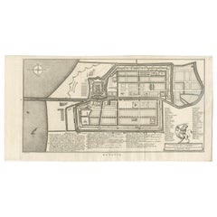
Batavia in Bloom: A 1750 Hand-Colored Engraving of a Cartographic Treasure
About the Item
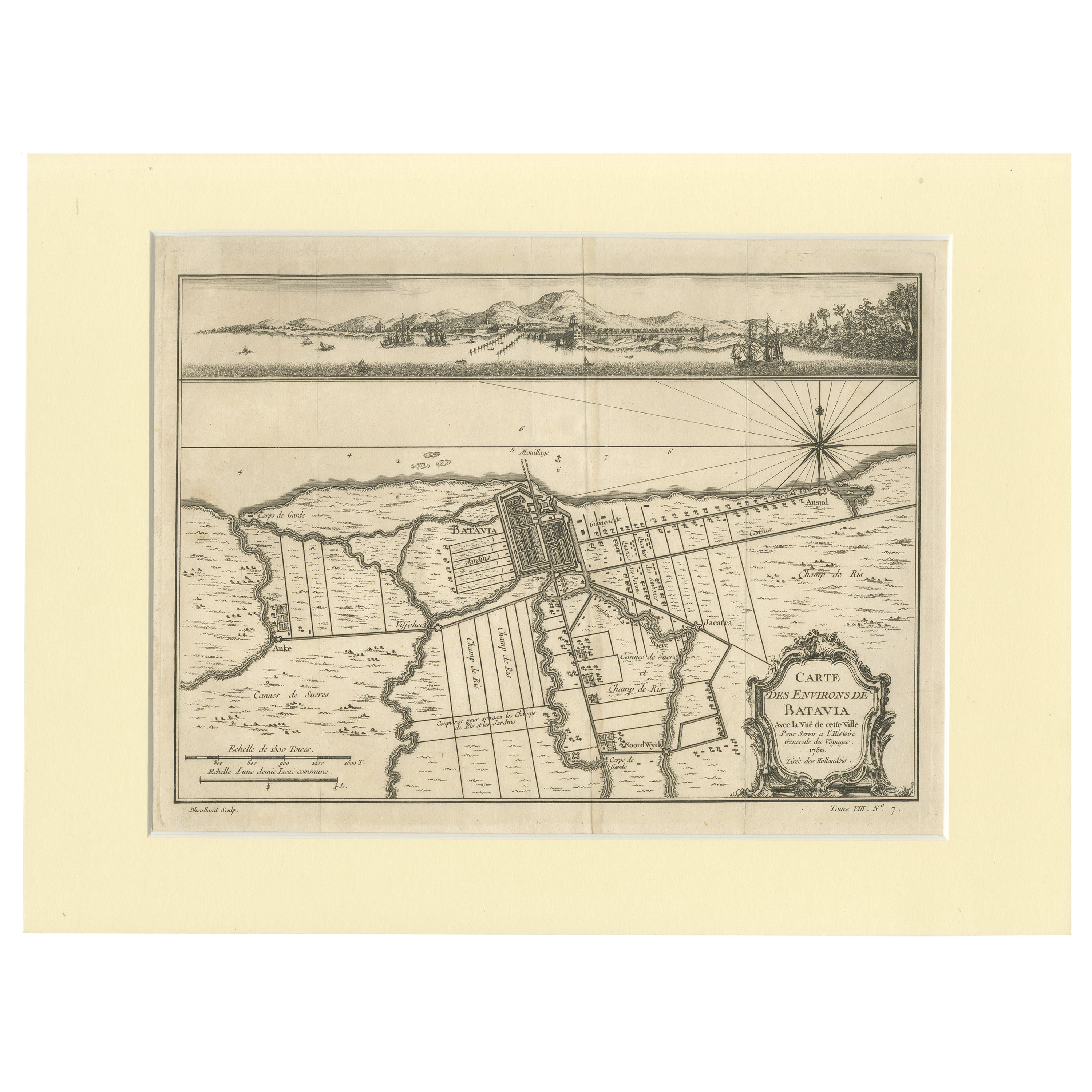
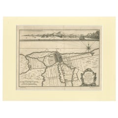
The engraving titled "Carte des Environs de Batavia avec la vue de cette ville" (Map of the Environs of Batavia with a View of This City) is a detailed hand-colored map that was intended to accompany the "Histoire Générale des Voyages" in 1750 by Bellin. It is a remarkable historical document that showcases Batavia, known today as Jakarta, during the Dutch colonial period.
The map depicts the city and its surroundings with meticulous detail, indicating roads, buildings, and natural features such as rivers and the coastline. Above the main map, there's an inset panoramic view that illustrates the profile of the city as seen from the harbor, with European ships at anchor and local boats in the foreground, which adds a vivid and dynamic aspect to the representation.
Notably, the map includes a decorative cartouche, which is artistically embellished with elements that might reflect the cultural and economic significance of Batavia at the time. The precise hand-coloring enhances the map's features, making it not only a navigational tool but also a work of art. Such engravings were crucial in disseminating knowledge about distant lands during the age of exploration and were highly valued by scholars and collectors.
This particular piece serves as a testament to the cartographic and artistic skills of the period, as well as a valuable historical record of Batavia’s urban landscape in the mid-18th century. It likely served as both a practical reference for travelers and a visually striking reminder of the Dutch Republic's expansive reach during its Golden Age.
- Dimensions:Height: 12.21 in (31 cm)Width: 10.24 in (26 cm)Depth: 0 in (0.02 mm)
- Materials and Techniques:Paper,Engraved
- Period:
- Date of Manufacture:1750
- Condition:Good. Folding lines from the original publication. Showing some wear and minor offset. Later handcoloring. Please study image carfully.
- Seller Location:Langweer, NL
- Reference Number:Seller: BG-136231stDibs: LU3054337695262
About the Seller
5.0
Platinum Seller
These expertly vetted sellers are 1stDibs' most experienced sellers and are rated highest by our customers.
Established in 2009
1stDibs seller since 2017
1,953 sales on 1stDibs
Typical response time: <1 hour
- ShippingRetrieving quote...Ships From: Langweer, Netherlands
- Return PolicyA return for this item may be initiated within 14 days of delivery.
More From This SellerView All
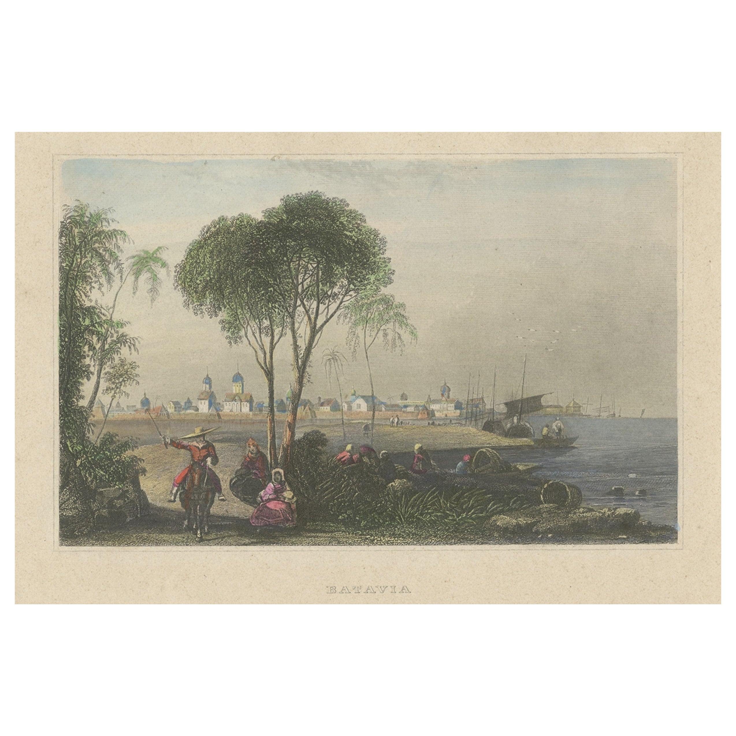
- Hand-Colored Steel Engraving of Batavia 'Jakarta', Indonesia, Ca.1840Located in Langweer, NLAntique print titled 'Batavia'. Steel engraving of Batavia (Jakarta), Indonesia. Originates from 'Meyers Universum'. Artists and Engravers: Jos...Category
Antique 1840s Prints
MaterialsPaper
- Old Engraving of Batavia 'Jakarta, Indonesia' with Map and Harbour View, 1750Located in Langweer, NLAntique map titled 'Carte des environs de Batavia '. French map of the Batavia area (Jakarta) in Indonesia. With cartouche, scale and compass rose. Published circa 1750. The map i...Category
Antique 1750s Maps
MaterialsPaper
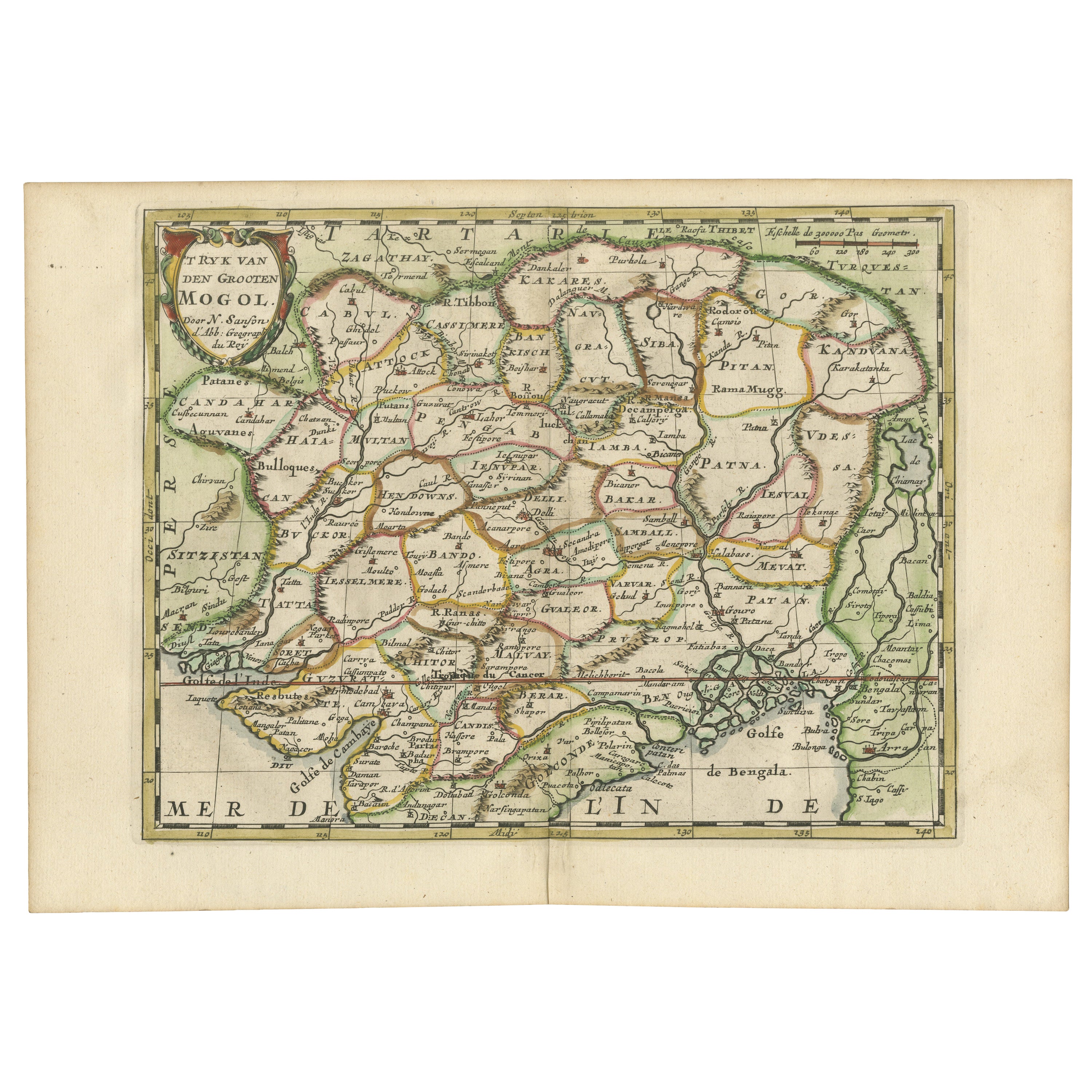
- Cartographic Elegance of the Mughal Dominion in a Hand-Colored Antique Map, 1705Located in Langweer, NLThis original antique map titled “'T Ryk van den Grooten Mogol” by Nicolas Sanson from 1705 is an interesting historical artifact. It depicts the extent of the Mughal Empire in North...Category
Antique Early 1700s Maps
MaterialsPaper
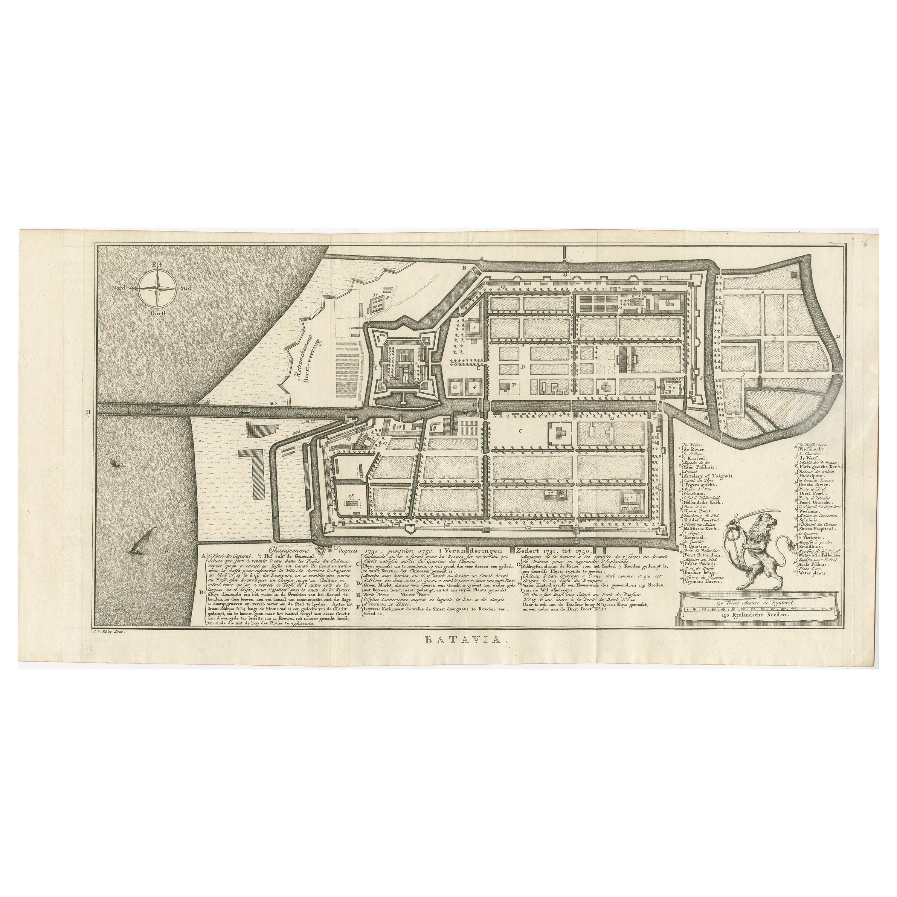
- Antique Map of Batavia by Van Schley 'c.1750'Located in Langweer, NLAntique map titled 'Batavia'. Original antique map of Batavia, Jakarta, Indonesia. This print originates from the Dutch edition of Prevost's 'Histoire Generale des Voyages' (Paris 17...Category
Antique Mid-18th Century Prints
MaterialsPaper
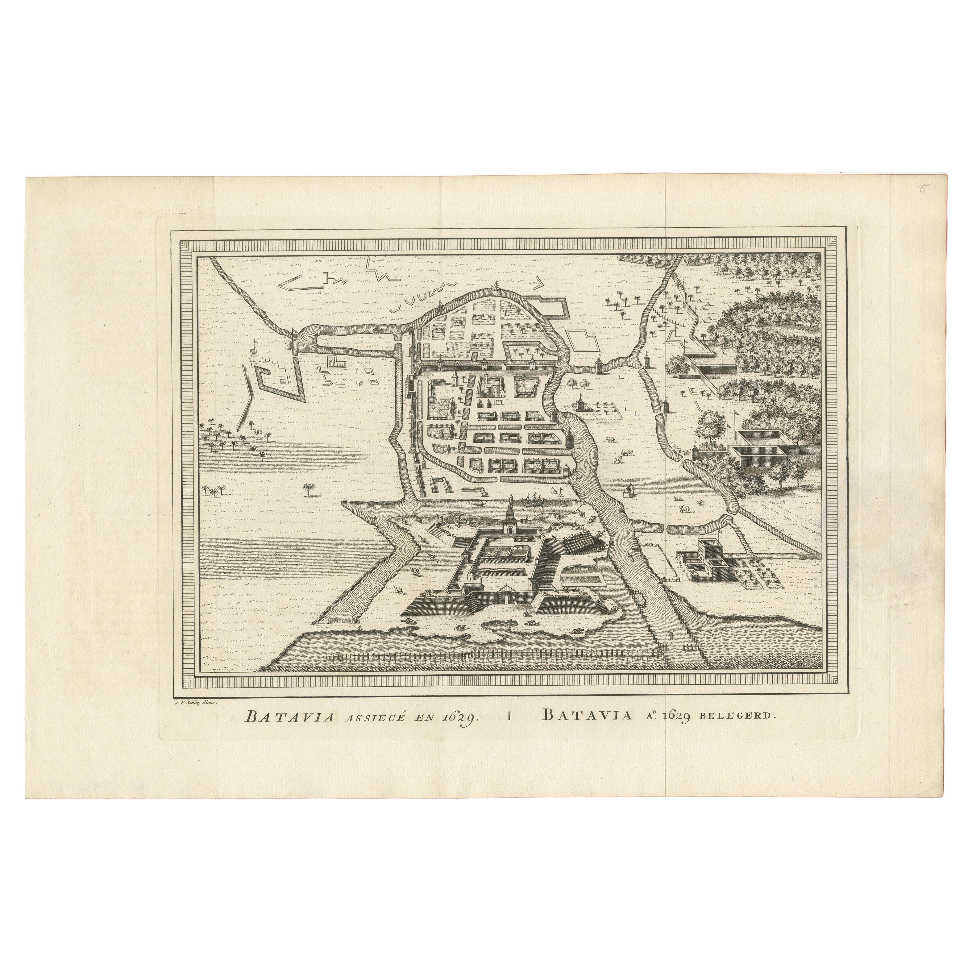
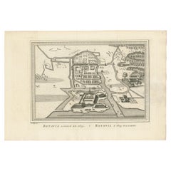
- Antique Map of the Siege of Batavia by Van Schley 'c.1750'Located in Langweer, NLAntique map titled 'Batavia assiecé en 1629 - Batavia 1629 belegerd'. Bird's eye view map of the siege of Batavia in 1629, Jakarta, Indonesia. This print originates from the Dutch ed...Category
Antique Mid-18th Century Prints
MaterialsPaper
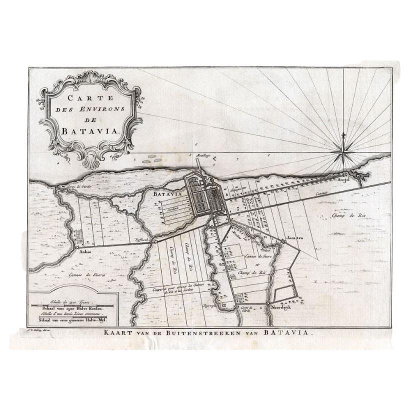
- Antique Map of the Region of Batavia by Van Schley, c.1750Located in Langweer, NLAntique map titled 'Carte des environs de Batavia - Kaart van de Buitenstreken van Batavia'. Map of the Batavia area (Jakarta) in Indonesia. With cartouche, scale and compass rose. P...Category
Antique 18th Century Maps
MaterialsPaper


You May Also Like
- Antique Lithography Map, Isle of Wight, English, Framed, Engraving, CartographyLocated in Hele, Devon, GBThis is an antique lithography map of the Isle of Wight. An English, framed atlas engraving of cartographic interest, dating to the early 19th century and later. Superb lithography ...Category
Antique Early 19th Century British Regency Maps
MaterialsWood
- Antique Lithography Map, Worcestershire, English, Framed Engraving, CartographyLocated in Hele, Devon, GBThis is an antique lithography map of Worcestershire. An English, framed atlas engraving of cartographic interest, dating to the early 19th centur...Category
Antique Early 19th Century British Regency Maps
MaterialsWood
- Antique Lithography Map, Northumberland, English, Framed, Engraving, CartographyLocated in Hele, Devon, GBThis is an antique lithography map of Northumberland. An English, framed atlas engraving of cartographic interest, dating to the mid 19th century a...Category
Antique Mid-19th Century British Victorian Maps
MaterialsWood
- Antique Lithography Map, Gloucestershire, English, Framed Engraving, CartographyLocated in Hele, Devon, GBThis is an antique lithography map of Gloucestershire. An English, framed atlas engraving of cartographic interest, dating to the mid 19th century ...Category
Antique Mid-19th Century British Victorian Maps
MaterialsWood
- Antique Lithography Map, Lincolnshire, English, Framed, Engraving, CartographyLocated in Hele, Devon, GBThis is an antique lithography map of Lincolnshire. An English, framed atlas engraving of cartographic interest, dating to the mid 19th century and...Category
Antique Mid-19th Century British Victorian Maps
MaterialsWood
- Antique Lithography Map, Bedfordshire, English, Framed Engraving, CartographyLocated in Hele, Devon, GBThis is an antique lithography map of Bedfordshire. An English, framed atlas engraving of cartographic interest, dating to the mid 19th century and...Category
Antique Mid-19th Century British Victorian Maps
MaterialsWood


Recently Viewed
View AllMore Ways To Browse
Engraved Cross
Collectors And Curiosities
Minature Map
Anguilla Map
James Calvert Smith
Winkler Prins
A Plan City And Castle Of Batavia
Malacca Strait Map
John Speed Isle Of Wight Maps
Antique Map Of Shanghai
Heinrich Kiepert On Sale
Old Teak Petite Artisan
Antique Maps Of Amsterdam
Antique Map Coats Of Arms
Albania Antique Map
Framed Map India
Maps Balkans
Paraguay Antique Map