Items Similar to Interesting Map of the Atlantic Showing Nelson's and Trade Routes, 1817


Want more images or videos?
Request additional images or videos from the seller
1 of 6
Interesting Map of the Atlantic Showing Nelson's and Trade Routes, 1817
About the Item
Antique map titled 'Chart of the North Atlantic Ocean with Tracks of the Shipping to West Indies, North America, &cc'. Large map of the Atlantic, showing the tracks of the ships trading in North America and the Caribbean, Lord Nelson's pursuit of the French in 1805, and a number of interesting annotations in various parts of the Atlantic.
Artist and Engravers: John Thomson (1777-ca. 1840) was a commercial map publisher active in Edinburgh. He specialized in guide books and atlases and is primarily known for his Atlas of Scotland (1832) and the New General Atlas, first published in 1817 and reissued for the next quarter century.
Condition: Very good, please study image carefully.
We also offer thousands of antique prints covering fields of interest as diverse as architecture, natural history, religion, ethnology and many more. Antique prints have long been appreciated for both their aesthetic and investment value. They were the product of engraved, etched or lithographed plates. These plates were handmade out of wood or metal, which required an incredible level of skill, patience and craftsmanship. Whether you have a house with Victorian furniture or more contemporary decor an old engraving can enhance your living space.
- Creator:John Thomson (Artist)
- Dimensions:Height: 21.26 in (54 cm)Width: 27.76 in (70.5 cm)Depth: 0 in (0.01 mm)
- Materials and Techniques:
- Period:
- Date of Manufacture:1817
- Condition:Condition: Very good, please study image carefully.
- Seller Location:Langweer, NL
- Reference Number:

John Thomson
Thomson lives and paints in California, Mexico and the Caribbean. His paintings, drawings, prints, ceramics, and color photographs have been exhibited by many leading galleries and design firms throughout the United States, and abroad. Over 4000 of his abstract creations are represented in private, and public collections around the world. Thomson earned his BA in Arts, 1964 from Chico State College and MA in Painting, 1970, from Chico State University.
About the Seller
5.0
Platinum Seller
These expertly vetted sellers are 1stDibs' most experienced sellers and are rated highest by our customers.
Established in 2009
1stDibs seller since 2017
1,938 sales on 1stDibs
Typical response time: <1 hour
- ShippingRetrieving quote...Ships From: Langweer, Netherlands
- Return PolicyA return for this item may be initiated within 14 days of delivery.
More From This SellerView All
- Antique Map of the Atlantic Islands, 1817Located in Langweer, NLAntique map titled 'Atlantic Islands'. Large map of the Atlantic Islands include the Cape Verde islands, Canary islands, Azore islands and Madeira islands. Also included a view of th...Category
Antique Early 19th Century Maps
MaterialsPaper
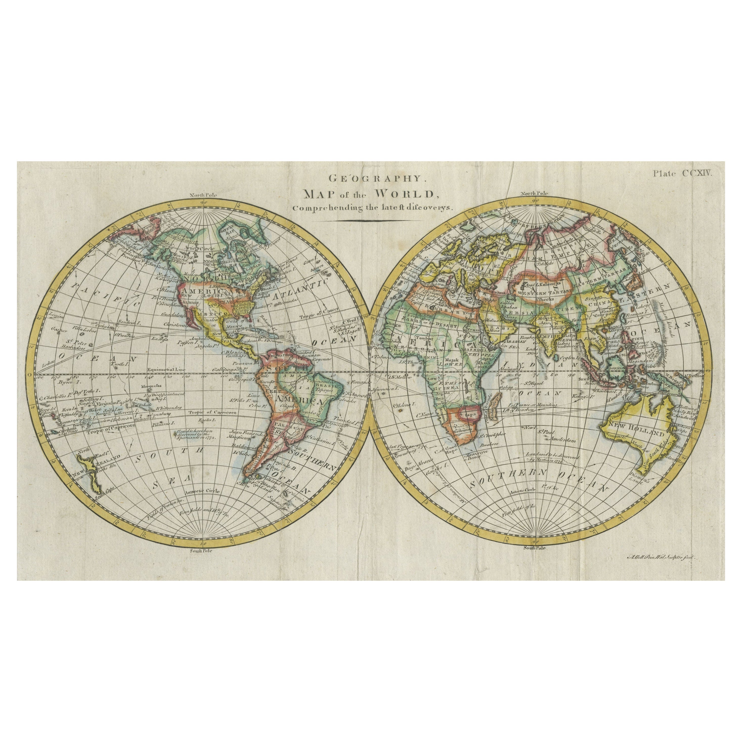
- Interesting Original Antique Hemisphere Map Showing the Latest DiscoveriesLocated in Langweer, NLAntique world map titled 'A Map of the World from the best Authorities'. Detailed map of the World, showing tracks of Captain James Cook in his 3 voyages in great detail. The map is ...Category
Antique Late 18th Century Maps
MaterialsPaper
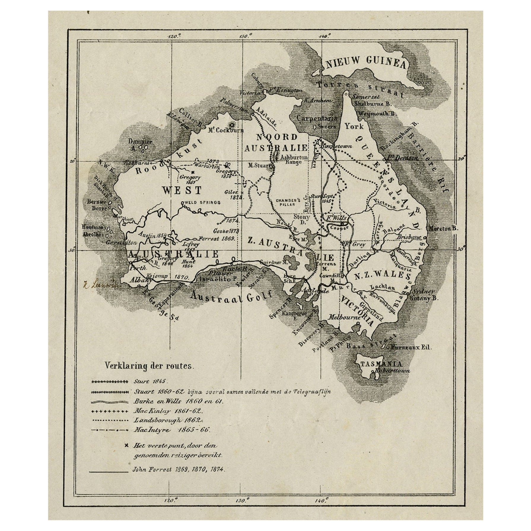
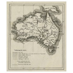
- Old Map of Australia Showing The Routes of the Main Explorers, ca.1900Located in Langweer, NLAntique print, untitled. This map shows Australia with the routes of explorers in the continent and marking the furthest point reached.. Source unknown, to be determined. Artists ...Category
Antique Early 1900s Maps
MaterialsPaper
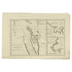
- Detailed Map of New Zealand Showing the Route of Capt. Cook's First Voyage, 1803Located in Langweer, NLAntique map New Zealand titled 'De Rivier de Theems en Mercurius Baai in Nieuw Zeeland'. Detailed map of New Zealand showing the route of Capta...Category
Antique 19th Century Maps
MaterialsPaper
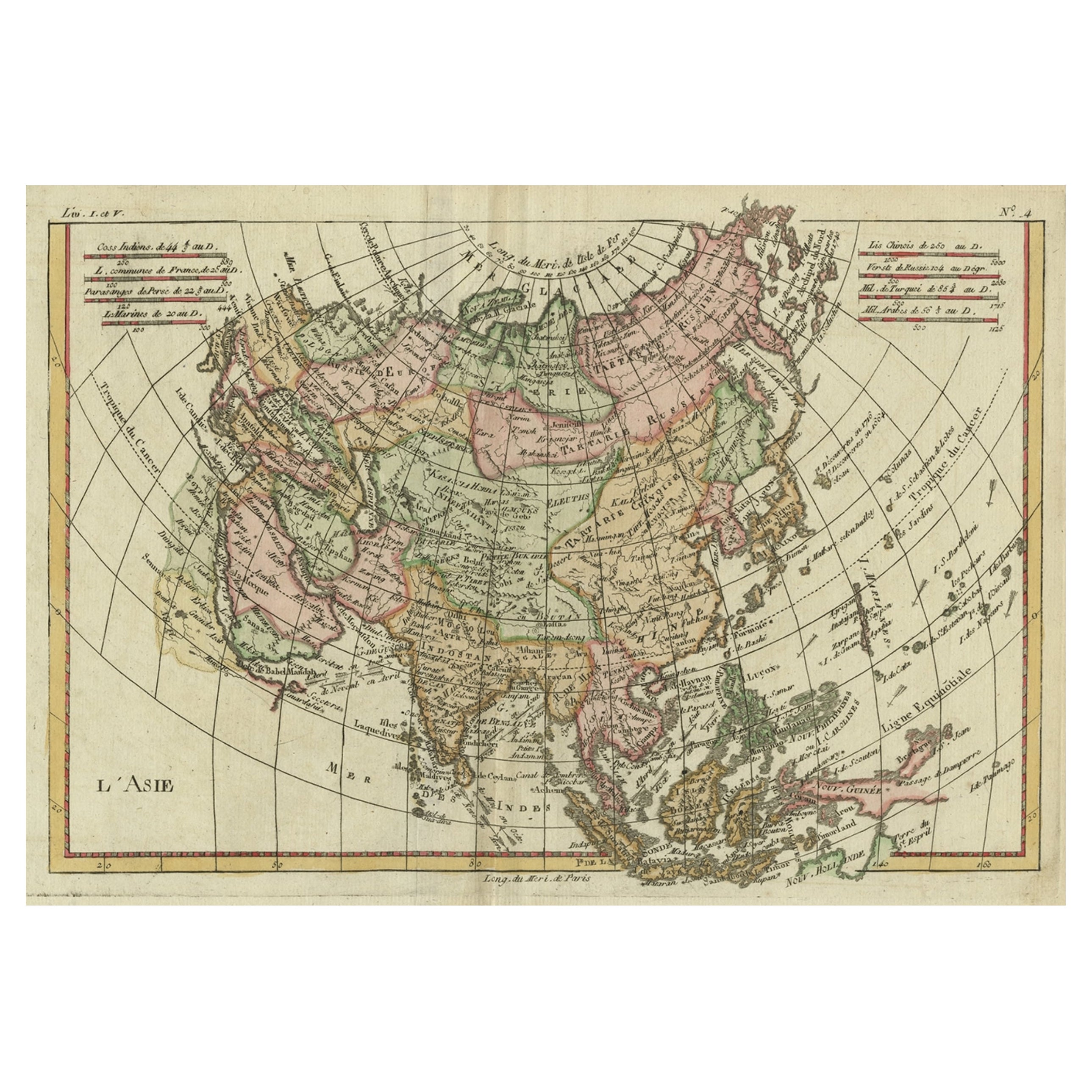
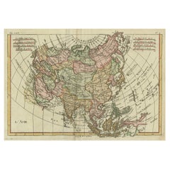
- Antique Map of Asia, Showing Tradewinds, Silke Route Cities Etc, c.1780Located in Langweer, NLAntique map titled 'L'Asie.' Map of Asia. Offers considerable detail considering the size, showing the tradewinds in the Pacific and Indian Oceans as well as numerous Silk Route citi...Category
Antique 18th Century Maps
MaterialsPaper
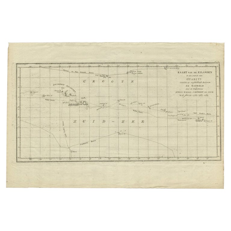
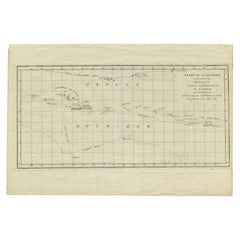
- Antique Map of French Polynesia by Cook Showing His Route, 1803Located in Langweer, NLAntique map Tahiti titled 'Kaart van de Eilanden in den omtrek van Otahiti (..)'. Antique map of French Polynesia with the tracks around the island of Tahiti by Captain Byron, Wallis...Category
Antique 19th Century Maps
MaterialsPaper


You May Also Like
- Original Antique Map of The World by Thomas Clerk, 1817Located in St Annes, LancashireGreat map of The Eastern and Western Hemispheres On 2 sheets Copper-plate engraving Drawn and engraved by Thomas Clerk, Edinburgh. Published by Mackenzie And Dent, 1817 ...Category
Antique 1810s English Maps
MaterialsPaper
- Original Antique Map of Spain and Portugal by Thomas Clerk, 1817Located in St Annes, LancashireGreat map of Spain and Portugal Copper-plate engraving Drawn and engraved by Thomas Clerk, Edinburgh. Published by Mackenzie And Dent, 1817 Unframed.Category
Antique 1810s English Maps
MaterialsPaper
- Original Antique Map of China by Thomas Clerk, 1817Located in St Annes, LancashireGreat map of China Copper-plate engraving Drawn and engraved by Thomas Clerk, Edinburgh. Published by Mackenzie And Dent, 1817 Unframed.Category
Antique 1810s English Maps
MaterialsPaper
- Original Antique Map of South America by Thomas Clerk, 1817Located in St Annes, LancashireGreat map of South America Copper-plate engraving Drawn and engraved by Thomas Clerk, Edinburgh. Published by Mackenzie And Dent, 1817 Unframed.Category
Antique 1810s English Maps
MaterialsPaper
- Original Antique Map of South East Asia by Thomas Clerk, 1817Located in St Annes, LancashireGreat map of South East Asia Copper-plate engraving Drawn and engraved by Thomas Clerk, Edinburgh. Published by Mackenzie And Dent, 1817 Unframed.Category
Antique 1810s English Maps
MaterialsPaper
- Map of the Republic of GenoaLocated in New York, NYFramed antique hand-coloured map of the Republic of Genoa including the duchies of Mantua, Modena, and Parma. Europe, late 18th century. Dimension: 25...Category
Antique Late 18th Century European Maps


